Appendix D LAND DEVELOPMENT AND SUBDIVISION REGULATIONS
ARTICLE I
Authority, Intent and Adoption
§ 101. Authority.
§ 102. Purpose.
§ 103. Construction and Intent.
§ 104. Effective Date.
§ 105. Vested Rights, Continuation of Prior Regulations.
§ 106. Adoption and Amendment of Regulations.
§ 107. Severability.
ARTICLE II
Definitions
§ 201. Definitions.
ARTICLE III
General Requirements
§ 301. General Procedures.
§ 302. Pre-Application and Concept Plan Review.
§ 303. Public Hearing.
§ 304. Land Unsuitable for Development.
§ 403. Flexible Design Residential Development.
ARTICLE V
Administration
§ 501. The Administrative Officer.
| § | 502. The Technical Review Committee. |
| § | 503. Administrative and Professional Review Fees. |
§ 504. Meetings, Votes, Decisions and Records.
§ 505. Board of Appeal.
§ 506. Appeals to Superior Court.
§ 507. Enforcement and Penalties.
ARTICLE VI
Administrative Subdivision
§ 601. Administrative Subdivision.
§ 602. Review Procedure.
§ 603. Planning Board Decision.
ARTICLE VII
Minor Subdivision and Land Development
| § | 305. | Dedication of Land for Public |
| § | 306. | Purposes. Waivers and Modifications. |
| § | 307. | Required Findings. |
§ 308. Precedence of Approvals.
ARTICLE IV
Special Requirements
§ 401. Phasing.
§ 402. Environmental Impact Statement.
ARTICLE VIII
Major Subdivision and Land Development
| § | 701. | Minor Subdivision and Land |
| § | 702. | Development. Review Procedure. |
| § | 703. | Planning Board Decision. |
| § | 801. | Major Subdivision and Land |
| § | 802. | Development. General Review Procedures. |
| | | |
§ 803. Master Plan Review Procedures
§ 804. Planning Board Decision — Master Plan.
§ 805. Preliminary Plan Review Procedures.
§ 806. Planning Board Decision — Preliminary Plan.
§ 807. Final Plan Review Procedures.
§ 808. Planning Board Decision — Final Plan.
ARTICLE IX
Public Improvement Guarantees and Recording of Plans and Plats
§ 901. Guarantees of Public Improvements.
§ 902. Procedures for Completion of Improvements.
§ 903. Improvement Guarantees.
§ 904. Required Forms of Guarantees.
§ 905. Maintenance Guarantees.
| § | 906. | Acceptance of Improvements. |
| § | 907. | Recording of Plans and Plats. |
| § | 908. | Changes to Approved Plans and Plats. |
ARTICLE X
Design, Construction and Improvement Standards
§ 1001. Developer Expense.
§ 1002. General Site Design Standards.
§ 1003. Site Analysis.
§ 1004. Lot Design Standards.
| § | 1005. | Easements. |
| § | 1006. | Street Design Standards. |
§ 1007. Bounds.
§ 1008. Planting and Landscaping.
§ 1009. Utilities.
§ 1010. Stormwater Management.
§ 1011. Water Quality.
| § | 1012. | Erosion and Sediment Control. |
| § | 1013. | Areas of Special Flood Hazard. |
| § | 1014. | Off-Site Improvements. |
| § | 1015. | General Construction Procedures and Inspections. |
| | | Appendix A Administrative Subdivision Checklist |
Appendix B Minor Subdivision and Minor Land Development Plan Checklists
Appendix C Major Subdivision and Major Land Development Plan Checklists
Appendix D New Shoreham Viewshed Map (Reserved)
Appendix E List of Amendments to Land Development and Subdivision Regulations as Amended on June 8, 2011
Editor's Note: Printed herein are the land development and subdivision regulations of the town, as adopted by the town council and effective on November 17, 1994, as amended through June 8, 2011. Subsequent amendments to the ordinance are indicated by parenthetical history notes following amended provisions. The absence of a history note indicates that the provision remains unchanged from the original ordinance as amended through June 8, 2011. Obvious misspellings and punctuation errors have been corrected without notation.
ARTICLE I
Authority, Intent and Adoption
§ 101. Authority.
These Land Development and Subdivision Regulations are adopted pursuant to Title 45, Chapter 23, Sections 25 through 74 of the Rhode Island General Laws of 1956, as amended, known as the "Rhode Island Land Development and Subdivision Review Enabling Act of 1992", and Chapter 16 of the Ordinances of the Town of New Shoreham adopted September 15, 1993 pursuant to Rhode Island General Laws 45-23-21.
§ 102. Purpose.
A. The purpose of these Regulations is to establish procedural and substantive provisions for the subdivision and development of land that will, consistent with New Shoreham's Comprehensive Plan and Zoning Ordinance, accomplish the following:
1. Protect the public health, safety and welfare of the community;
2. Provide for the orderly, thorough and expeditious review and approval of subdivisions and land development projects;
3. Promote high quality, and appropriate design and construction of subdivisions and land development projects;
4. Protect existing natural and built environments and mitigate the significant negative impacts of proposed development on those environments;
5. Promote subdivision and land development designs that are well-integrated into surrounding neighborhoods, and concentrate development in areas that can best support intensive use because of natural characteristics and existing infrastructure;
6. Provide for design and construction standards that are appropriate to the community;
7. Require measures for mitigating the impact of new development on the community that are based on clear documentation of needs and are fairly applied and administered;
8. Direct the development of land consistent with state-of-the-art practices that promote and foster growth in a manner that protects the Town's distinctive character while at the same time accommodating economic growth;
9. Guide land development with an emphasis on siting subdivision improvements so as to allow for the maximum preservation of existing natural features;
10. Insure that proposed designs institute best management practices that acknowledge existing site constraints and the natural setting;
11. Protect the Town's recognized sole source aquifer to insure the quality and quantity of the Town's water supply, and;
12. Protect the Town's unique and important coastal features such as shorelines, dunes, beaches, bluffs, ponds and wetlands.
§ 103. Construction and Intent.
A. These Regulations are not intended to supersede, abrogate or interfere with any provision of any ordinance of the Town of New Shoreham.
B. These Regulations are intended to be interpreted so as to be consistent with, and further the implementation of, the New Shoreham Comprehensive Plan and the Rhode Island Land Development and Subdivision Review Enabling Act of 1992. Consistency with the Comprehensive Plan means in accordance with the goals, policies, procedures, maps and other policy statements in the Plan.
C. In the event of a conflict in these Regulations between any general regulation or provision and one more specific, the specific shall be controlling.
§ 104. Effective Date.
These Regulations shall take effect on November 17, 1994, and shall supersede all other subdivision regulations in effect at the time of such adoption.
§ 105. Vested Rights, Continuation of Prior Regulations.
A. Subdivisions which have been submitted to the Planning Board for approval under the provisions of the Regulations in effect prior to an adoption or amendment may be continued to be reviewed by the Planning Board and approved under those Regulations in effect at the time in accordance with the following:
1. Final Approvals. Any subdivision which, at the time of adoption or amendment of these Regulations, has received a final approval, or final approval with conditions, from the Planning Board, may initiate or construct any part of the development, or record said plans in accordance with the Subdivision Regulations in effect at the time final approval was granted. The Planning Board, may, in its discretion, grant extensions to any such final approval in accordance with the procedure for such extensions as set forth in the Regulations in effect at the time of the final approval.
2. Preliminary Approvals. Any subdivision which, at the time of adoption or amendment of these Regulations, has received a preliminary approval, or preliminary approval with conditions, from the Planning Board, may continue to be reviewed by the Planning Board in accordance with the Subdivisions Regulations in effect at the time preliminary approval was granted provided any one of the following conditions have been met:
a. The final plan, including all the material required in the final plan checklist, is filed with the Planning Department within one year from the date of the preliminary approval; or,
b. The subdivision is located within an area, and is of a nature to be, within the jurisdiction of the Rhode Island Coastal Resources Management Council (CRMC) and the preliminary plan, as approved by the Planning Board, has been filed with CRMC for an assent or approval as required; or,
c. The subdivision is located within an area, and is of a nature to be, within the jurisdiction of the Rhode Island Department of Environmental Management (RIDEM) and the preliminary plan, as approved by the Planning Board, has been filed with RIDEM for a permit or approval as required; or,
d. The applicant has expended significant monies in the preparation of the preliminary plans in an amount that, if preliminary approval were to become void and a new application under the revised subdivision regulations were to be required, a significant economic hardship would result. The Planning Board shall determine what constitutes "significant economic hardship".
3. Other Status. Any subdivision which, at the time of adoption or amendment of these Regulations, has not received a final or preliminary approval; or has been reviewed by the Planning Board for preliminary but no approval therefore has been granted; or has received a preliminary approval more than one year prior to the date of the adoption or amendment of these Regulations; or for which only a pre-application conference or conferences have been conducted, shall be required to be reviewed under the Subdivision Regulations currently in place pursuant to the Rhode Island Land Development and Subdivision Review Enabling Act of 1992.
§ 106. Adoption and Amendment of Regulations.
A. These Land Development and Subdivision Review Regulations, or any part hereof or provision herein, may be adopted, repealed or amended by the Planning Board under the following procedures:
1. Notice of a public hearing on any proposed adoption, repeal or amendment shall be published in a newspaper of general circulation within the Town at least once each week for three successive weeks prior to the date of the hearing, which may include the week in which the hearing is to be held. The newspaper notice shall be published as a display advertisement, using a type size at least as large as the normal type size used by the newspaper in its news articles. The advertisement shall:
a. Specify the date, time and place of the public hearing;
b. Indicate that adoption, amendment or repeal the Town's Land Development and Subdivision Review Regulations is under consideration;
c. Contain a statement of the proposed amendment that may be printed once in its entirety, or may summarize or describe the matter under consideration;
d. Advise those interested where and when a copy of the matter under consideration may be obtained or examined and copied; and
e. State that the proposed amendment may be altered or amended prior to the close of the public hearing without further advertising, as a result of further study or because of the views expressed at the public hearing, provided that any such alteration or amendment must be presented for comment in the course of the public hearing.
2. Notice of the public hearing shall be sent to the following:
a. The Associate Director of the Division of Planning of the Rhode Island Department of Administration. Said notice, which may be a copy of the newspaper advertisement, shall be sent at least two weeks prior to the public hearing.
b. The governing body of any state or municipal water department or agency, special water district, or private water company that has riparian rights to a surface water resource and/or a surface watershed that is used or is suitable for use as a public water source located within the Town, provided that the governing body of the state or municipal water department or agency, special water district, or private water company has filed with the Town Building Official a map survey showing the areas of surface water resources and/or watersheds, and parcels of land within 2,000 feet of the areas of surface water resources and/or watersheds, pursuant to Rhode Island General Laws § 45-24-53(E).
3. The Planning Board shall conduct a public hearing at the date, time and place specified in the newspaper advertisement and notices. At the hearing, opportunity shall be given to all persons interested to be heard upon the action proposed.
B. Printed copies of these Regulations, including all appendices, shall be available to the general public and shall be revised to include all amendments. A reasonable charge may be made for copies. Upon publication of any adoption or amendment, copies shall be sent to the Planning Division of the Rhode Island Department of Administration, and to the State Law Library.
§ 107. Severability.
If any section, subsection, part, portion or provision of these Regulations to be held invalid by any court of competent jurisdiction, such invalidity shall not affect the validity of the remainder of these Regulations.
ARTICLE II
Definitions1
§ 201. Definitions.
The following words and phrases, when used in these Regulations, shall have the following meaning, unless otherwise provided:
ADMINISTRATIVE OFFICER — The town official who shall administer the Land Development and Subdivision Review Regulations and who shall coordinate with local boards and commissions, town staff and state agencies. The Administrative Officer may be a member of, or the chair of, the Planning Board, or an appointed official of the Town.
ADMINISTRATIVE SUBDIVISION — Re-subdivision of existing lots which yields no additional lots for development, and involves no creation or extension of streets. Such re- subdivision shall only involve divisions, mergers, mergers and division, or adjustment of boundaries of existing lots.
BOARD OF APPEAL — The New Shoreham Zoning Board of Review, as designated by ordinance, sitting as the Board of Appeal, shall be the local review authority for appeals of actions of the Administrative Officer and the Planning Board on matters of land development and subdivision.
BOND — A type of improvement guarantee. See "Improvement Guarantee".
BUFFER — Land which is maintained in either a natural or landscaped state, and is used to screen and/or mitigate the impacts of development on surrounding areas, properties or rights- of-way.
BUILDABLE LOT — A lot where construction for the use(s) permitted on the site under the New Shoreham Zoning Ordinance is considered practicable by the Planning Board, considering the physical constraints to development of the site as well as the requirements of the pertinent federal, state and local regulations.
CERTIFICATE OF COMPLETENESS — A notice issued by the Administrative Officer informing an applicant that the application is complete and meets the requirements of the New Shoreham Land Development and Subdivision Review Regulations, and that the applicant may proceed with the approval process.
COASTAL FEATURE — As defined, designated and delineated by the Rhode Island Coastal Resources Management Council, or its successor.
CONCEPT PLAN — A drawing with accompanying information showing the basic elements of a proposed land development plan or subdivision as used for pre-application meetings and early discussion, and classification of the project within the approval process.
CONSISTENCY WITH THE COMPREHENSIVE PLAN — A requirement of all local land use regulations which means that all such regulations and subsequent actions shall be in accordance with the public policies arrived at through detailed study and analysis and adopted by the municipality as the Comprehensive Community Plan as specified in Rhode Island General Laws 45-22.2-3.
1. Note — Underline denotes a town definition, all others are state definitions.
CUL-DE-SAC — The terminus of a street that has only one outlet, laid out to provide a circular or other type of turn-around for vehicles at the closed end.
DEDICATION, FEE-IN-LIEU-OF — Payments of cash which are authorized in these Regulations when requirements for mandatory dedication of land are not met because of physical conditions of the site or other reasons.
DEVELOPABLE LAND — Land which is considered suitable for development, measured for the purposes of determining allowable density. Developable land shall exclude the following:
1. All areas occupied by coastal wetlands (see "Wetland, Coastal"); coastal features including beaches, bluffs and dunes, as determined by the CRMC; and freshwater wetlands and areas of perimeter wetland within 50 feet of the edge of any wetland (see "Wetland, Freshwater").
2. All the land area within easements serving other lots, including but not limited to sewage disposal systems, or wells, but not including scenic and conservation easements, or easements for access.
DEVELOPMENT REGULATION — Zoning, subdivision, land development plan, development plan review, historic district, official map, flood plain regulation, soil erosion control or any other governmental regulation of the use and development of land.
DIVISION OF LAND — A subdivision.
EASEMENT — The right of a party to use all or part of the property of another for a specific purpose.
ENDORSEMENT — The signature of the Planning Board Chair, Vice-Chair or the Administrative Officer on an approved plat, permitting the recording of the plat.
ENVIRONMENTAL CONSTRAINTS — Natural features, resources or land characteristics that are sensitive to change and may require conservation measures or the application of special development techniques to prevent degradation of the site, or may require limited development, or in certain instances, may preclude development. See also, "Physical Constraints to Development".
ENVIRONMENTAL IMPACT STATEMENT — See § 402.
FINAL PLAN — The final stage of land development and subdivision review.
FINAL PLAT — The final drawing(s) of all or a portion of a subdivision or land development project, and any accompanying materials, to be recorded in the Land Evidence Records after approval by the Planning Board.
FLEXIBLE DESIGN RESIDENTIAL DEVELOPMENT — An alternative residential subdivision which makes use of flexible zoning and site sensitive design standards. See
§ 403.
FLOOD MAPS — The Federal Emergency Management Agency Flood Hazard Boundary Maps for the Town of New Shoreham.
FLOOR AREA, GROSS — See RI State Building Code.
GOVERNING BODY — The New Shoreham Town Council.
GREENWAY — A protected open space corridor for pedestrian use linking parks, nature preserves, cultural features, or historic sites with each other and with populated areas.
HAMMERHEAD — The terminus of a street, laid out to provide a turn-around area for vehicles.
IMPROVEMENT — Any natural or built item which becomes part of, or placed upon, or is affixed to, real estate.
IMPROVEMENT GUARANTEE — A security instrument accepted by the Town to ensure that all improvements, facilities, or work required by these Regulations, or as a condition of approval, will be completed in compliance with the approved plans and specifications of a development.
LAND DEVELOPMENT PROJECT — A project in which one or more lots, tracts, or parcels of land are to be developed or redeveloped as a coordinated site for a complex of uses, units, or structures, including but not limited to planned development and/or cluster development for residential, commercial, institutional, recreational, open space, and/or mixed uses as may be provided for in the Zoning Ordinance.
LAND DISTURBING ACTIVITY — Any physical land development activity which includes such actions as clearing of vegetation, moving or filling of land, removal or excavation of soil or mineral resources, or similar activities.
LOT AREA — The total area within the boundaries of a lot, excluding any street right-of- way, usually reported in acres or square feet.
MAINTENANCE GUARANTEE — Any security instrument which may be required and accepted by the Town to ensure that necessary improvements will function as required for a specific period of time. See "Improvement Guarantee."
MAJOR LAND DEVELOPMENT PLAN — Any land development plan not classified as a minor land development plan, and any land development project that includes non-residential development.
MAJOR SUBDIVISION — Any subdivision not classified as either an administrative subdivision or a minor subdivision.
MASTER PLAN — An overall plan for a proposed project site outlining general, rather than detailed, development intentions. It describes the basic parameters of a major development proposal, rather than giving full engineering details. A master plan is required for any major land development or major subdivision.
MINOR LAND DEVELOPMENT PLAN — A development plan for a project of three or fewer residential lots or units, provided such development does not require waivers or modifications as specified in these Regulations. All non-residential land development projects shall be considered major land development plans.
MINOR SUBDIVISION — A plan for the subdivision of land into three or fewer residential lots, provided that the subdivision does not require any waivers or modifications as specified in these Regulations.
MODIFICATION OF REQUIREMENTS — See § 306.
NON-BUILDABLE LOT — A parcel of land recorded in the Land Evidence Records that is created or reserved for a purpose other than present or future construction of buildings or structures.
OPEN SPACE — Land, primarily undeveloped, which may be public, semi-public or private, the purpose of which is to provide for the conservation of land and other natural resources and to provide park, recreational, historic and scenic areas.
PARCEL — A lot, or contiguous group of lots in single ownership or under single control, and usually considered a unit for purposes of development.
PARKING AREA OR LOT — All that portion of a development that is used by vehicles, being the total area used for vehicular access, circulation, parking, loading and unloading.
PHASE — A portion of a subdivision or land development to be developed, or sold as lots, at a particular time, as part of an effort to coordinate population growth with the availability of facilities and services.
PHASED DEVELOPMENT — Development where construction of public and/or private improvements proceeds by sections subsequent to approval of a master plan for the entire site.
PHYSICAL CONSTRAINTS TO DEVELOPMENT — Characteristics of a site or area, either natural or man-made, which present significant difficulties to construction of the uses permitted on that site, or would require extraordinary construction methods. See also "Environmental Constraints."
PLANNING BOARD — The Planning Board of the Town of New Shoreham.
PLAT — A drawing or drawings of a land development project or subdivision plan showing the location, boundaries, and lots lines of individual properties, as well as other necessary information as specified in these Regulations.
PRE-APPLICATION CONFERENCE — An initial meeting between developers and town representatives which affords developers the opportunity to present their proposals informally, and to receive comments and direction from town officials and others.
PRELIMINARY PLAN — The required stage of land development and subdivision review which shall require detailed engineered drawings and all required state and federal permits.
PUBLIC IMPROVEMENTS — Any street or other roadway, sidewalk, pedestrian way, tree, lawn, off-street parking area, drainage feature, or other facility for which the Town or its entities is presently responsible, or will ultimately assume the responsibility for maintenance and operation upon acceptance by the Town.
PUBLIC INFORMATIONAL MEETING — A meeting of the Planning Board, preceded by notice, open to the public and at which the public shall be heard.
RE-SUBDIVISION — Any change of an approved or recorded subdivision plat or in a lot recorded in the Land Evidence Records, or that affects the lot lines of any areas reserved for public use, or that affects any map or plan legally recorded prior to the adoption of these
Regulations. For the purposes of these Regulations any such action will constitute a subdivision.
RIGHT-OF-WAY — An easement for the purpose of passing through, or crossing property belonging to another.
STORM WATER DETENTION — A provision for storage of storm water runoff and the controlled release of such runoff during and after a flood or storm.
STORM WATER RETENTION — A provision for storage of storm water runoff.
STREET — A public or private thoroughfare used, or intended to be used, for passage or travel by motor vehicles. Streets are further classified by the functions they perform. See "Street Classification". As used herein, the term "road" shall be synonymous with street.
STREET CLASSIFICATION — A method of roadway organization which identifies a street hierarchy according to function within a road system, that is, types of vehicles served and anticipated volumes, for the purpose of promoting safety, efficient land use and design character of neighborhoods and districts. Local classifications shall use the following as major categories:
1. ARTERIAL - A major street that serves as an avenue for the circulation of traffic into, out of, or around the Town and carries high volumes of traffic.
2. COLLECTOR - A street whose principal function is to carry traffic between local streets and arterial streets, but that may also provide direct access to abutting properties.
3. LOCAL - Streets whose primary function is to provide access to abutting properties.
STREET, ACCESS TO — An adequate and permanent way of entering a lot. All lots of record shall have access to a public street for all vehicles normally associated with the uses permitted for that lot.
STREET, ALLEY — A public or private thoroughfare primarily designed to serve as secondary access to the side of rear of those properties whose principal frontage is on some other street.
STREET, PRIVATE — A thoroughfare established as a separate tract for the benefit of multiple, adjacent, properties and meeting specific town improvement standards. This definition shall not apply to driveways.
STREET, PUBLIC — All public property reserved or dedicated for street traffic.
STREET, RIGHT-OF-WAY — The entire area to be dedicated for street use, including the pavement or travel surface, and the areas on both sides of the pavement or travel surface that may be reserved for installation of sidewalks, utilities, drainage improvements or other purposes.
STREET, STUB — A portion of a street reserved to provide access to future development, which may provide for utility connections.
SUBDIVIDER — Any person who (1) having an interest in land, causes it, directly or indirectly, to be divided into a subdivision or who (2) directly or indirectly sells, leases, or develops or offers to sell, lease, or develop, any interest, lot, parcel, site, unit or plat in a subdivision, or who (3) engages directly or through an agent in the business of selling, leasing, developing, or offering for sale, lease, or development a subdivision or any interest, lot, parcel, site, unit or plat in a subdivision.
SUBDIVISION — The division, or re-division, or a lot, tract or parcel of land into two or more lots, tracts or parcels. Any adjustment to existing lot lines of a recorded lot by any means shall be considered a subdivision. All re-subdivision activity shall be considered a subdivision. The division of property for purposes of financing constitutes a subdivision.
TECHNICAL REVIEW COMMITTEE — A committee, which may be constituted and appointed by the Planning Board for the purpose of reviewing, commenting, and making recommendations to the Planning Board with respect to approval of land development and subdivision applications.
TEMPORARY IMPROVEMENT — Improvements built and maintained by a developer during construction of a development project and prior to release of the improvement guarantee, but not intended to be permanent.
VESTED RIGHTS — The right to initiate or continue the development of an approved project for a specified period of time, under the regulations that were in effect at the time of approval, even if, after the approval, the regulations change prior to the completion of the project.
WAIVER OF REQUIREMENTS — See § 306.
WETLAND, COASTAL — A salt marsh bordering on the tidal waters of this state and contiguous uplands extending no more than 50 yards inland therefrom, or as defined by Title 2, Chapter 1, § 14 of the Rhode Island General Laws as amended or replaced. (Ref. RIGL 45-22.2-2(28))
WETLAND, FRESHWATER — A marsh, swamp, bog, pond, river, river or stream floodplain or bank, area subject to flooding or storm flowage; emergent or submergent plant community in any body of fresh water; or any area within 50 feet of the edge of a bog, marsh, swamp, or pond, or as defined by Title 2, Chapter 1, § 20 of the Rhode Island General Laws as amended or replaced. (Ref. RIGL 45-22.2-4(29))
ARTICLE III
General Requirements
The following general requirements shall be applicable to all land development and subdivisions submitted for approval, unless otherwise specifically provided. Any inconsistency between these general requirements and other more specific requirements contained in these Regulations shall be resolved in favor of the more specific requirement.
§ 301. General Procedures.
A. Applications. The Planning Board shall consider each application for a subdivision or land development project approval according to the procedures set forth in these Regulations, unless otherwise specifically provided.
B. Checklists of Required Material. Any applicant for project approval who wishes the Planning Board to take some official action on any application shall submit all of the materials required by the applicable checklists provided herein (see Appendices), or available from the Administrative Officer. If the requested action is not applicable under any of the checklists provided herein, or available from the Administrative Officer, such as a request for an extension of an approval, the applicant shall submit a written request to the Administrative Officer describing the requested action to be taken by the Planning Board. The matter will be placed on the next available agenda of the Planning Board only if the Administrative Officer determines that all of the required material has been submitted and only after a Certificate of Completeness has been issued in accordance with these Regulations.
C. Letter of Transmittal. Any submission of materials to the Administrative Officer shall be accompanied by a cover letter or letter of transmittal indicating the date, the materials being submitted, the requested action and the person or persons transmitting the materials. No material shall be accepted by the Administrative Officer without said cover letter. Upon receipt of any materials, the Administrative Officer shall place the date and time of receipt upon them.
D. Signature of Owner Required. If an application for subdivision or land development approval is made by someone other than the owners of the land, which is the subject of the application, the applicant shall submit a written statement from the owners authorizing such application and specifically stating the authority of the person submitting the application. The Administrative Officer may request such supporting legal documentation for the file record as may be deemed appropriate.
E. Certification of a Complete Application. An application shall be complete for purposes of commencing the applicable time period for action when so certified by the Administrative Officer. Certification of a complete application shall be made in writing by the Administrative Officer upon a form provided to the applicant. In the event such certification of the application is not made within the time specified in these Regulations for the type of plan being proposed, the application shall be deemed complete for purposes of commencing the review period unless the application lacks information required for such applications as specified in the checklists, and the Administrative Officer has notified the applicant, in writing, of the deficiencies in the application.
F. Information Required. Notwithstanding the above, the Planning Board may subsequently require the applicant to correct any information found to be in error and/ or to submit additional information specified in the Regulations but not required by the Administrative Officer prior to certification, as is necessary to make an informed decision.
G. Review Periods. Where review is postponed, with the consent of the applicant, pending submission of further information or revision of information, the time period for review shall be stayed and shall resume when the Planning Board determines that the required application information is complete. For purposes of calculating mandatory review periods as provided in these Regulations, all days shall be considered to be calendar days.
H. Subdivision and Court Proceedings. Any subdivision, as the term is defined in these Regulations, which is required because of a court proceeding, such as suit for partition, to quiet title, resolve a boundary line dispute or otherwise, shall receive priority for review so as to complete the Planning Board's action on any such request in as timely a manner as possible to facilitate the court proceedings.
§ 302. Pre-Application and Concept Plan Review.
A. Staff Review Meeting. An applicant wishing to obtain Planning Board approval shall first contact the Administrative Officer to arrange a meeting with the applicable staff. At the staff meeting, the applicant and the staff shall determine if a pre-application meeting with the Planning Board is required by these Regulations, or is desired by either the applicant or the Town. A pre-application meeting with the Planning Board shall be required for all major subdivisions or major land development projects, and may be required or requested for any application to the Planning Board.
B. Pre-Application Submission. If a pre-application meeting is required or requested, the applicant shall submit all the information required by the checklist for pre-application meetings and concept review. The staff will review and comment on the checklist information and, if determined to be complete, will schedule the application to appear before the Planning Board.
C. Advice from Administrative Officer. If no pre-application meeting is required or requested, the applicant will be advised by the Administrative Officer as to the requirements of these Regulations and the procedure to be followed by the applicant.
D. Pre-Application Meetings. One or more pre-application meetings shall be held before the Planning Board for all major land development or major subdivision applications. Pre-application meetings may be held for administrative subdivisions, minor subdivisions or minor land development projects, upon request of either the Town, acting through the Administrative Officer, or the applicant. Pre-application meetings shall allow the applicant to meet with the Planning Board for advice as to the required steps in the approval process and to promote a mutual understanding between the applicant or property owner and the Planning Board so as to eliminate, where possible, costly retracing of steps in the submissions to follow. Where appropriate, town officials, boards, commissions, staff, and state agencies shall be notified of any pre- application meetings, and invited to provide comments on the proposed application.
E. Concept Plan Review. At the pre-application stage of an application, the applicant may request an informal concept plan review with the Planning Board or the Technical Review Committee to review the development proposal. The purpose of the concept plan review is also to provide the applicant with Planning Board or Technical Review Committee input in the formative stages of subdivision and land development concept design.
F. Planning Board. Action at Pre-Application Stage Pre-application meetings shall aim to encourage information sharing and discussion of project concepts among the participants. Pre-application discussions are intended for guidance of the applicant and shall not be considered approval of a project or of any of its elements. No formal action need be taken by the Planning Board at the pre-application meeting. However, the Planning Board may require the applicant to submit an Environmental Impact Statement (EIS) pursuant to § 402 of these Regulations. If an EIS is to be required, the Planning Board shall do so by formal vote and shall advise the applicant as the specific information the EIS must contain. The Board may seek the assistance of the Conservation Commission, town staff or others in deciding the need for, and parameters of, any EIS (See § 402).
§ 303. Public Hearing.
Whenever a public hearing is required for an application submitted to the Planning Board under these Regulations, the following procedures shall be the minimum requirements:
A. Notice Requirements.
1. Newspaper Notice. Public notice of the public hearing shall be given at least 14 days prior to the date of the hearing in a newspaper of general circulation in the Town. Newspaper advertisements shall be printed in the legal section of the classifieds using a type size at least as large as the normal type size used by the newspaper in its news articles, and shall contain the information specified below.
2. Certified Mail. Written notice of the public hearing shall also be sent by the applicant, upon forms to be provided to the applicant by the Town, to each owner of property within the notice area specified below. The notice shall be sent by certified mail, return receipt requested, not less than 14 days prior to the date of the hearing. As proof of such mailing, an affidavit of notice together with the white receipts for certified mail (PS Form 3800), with any returned or unclaimed envelopes, shall be provided to the Planning Board by the applicant prior to the time of the public hearing.
3. Contents. All required mail and newspaper notices shall specify, at a minimum, the following:
a. The date, time and place of the public hearing;
b. The Tax Assessor's plat and lot number of the subject property;
c. The street address of the subject property or, if no street address is available, a description of the location of the property;
d. A description of the nature of the application;
e. Notice as to the place and times where a copy of the plans of the proposed project may be examined; and
f. A statement indicating that the proposed project may be revised by the Planning Board as a result of further study or because of the views expressed at the public hearing.
B. Notice Area. The distance for notice of the public hearing shall be 500 feet from the perimeter of the parcel which is the subject of the application. Notice shall also be sent to the superintendents of the Town's water department and sewer department and to all owners of property with legal rights to the use of any right-of-way or easement which is proposed to service the development. The applicant is responsible for determining the correct names and addresses of all property owners required to be notified, and shall, at a minimum, be as accurate as the most current names and addresses listed in the Tax Assessor's records. The cost of all notices shall be borne by the applicant.
§ 304. Land Unsuitable for Development.
A. When calculating the number of residential building lots or units permitted on any parcel, only developable land (see definition) shall be considered. The following categories are considered unsuitable for development, and shall be deducted from the total acreage of the parcel when making density calculations:
1. All areas occupied by coastal wetlands; coastal features including beaches, bluffs and dunes, as determined by the Coastal Resources Management Council; and freshwater wetlands and areas of perimeter wetland within 50 feet of the edge of any wetland.
2. All the land area within easements serving other lots, including but not limited to sewage disposal systems, or wells, but not including scenic and conservation easements, or easements for access.
B. Land described in Subsections A.1 and A.2 above may be included as part of any lot in any subdivision or land development project; provided, however, that land unsuitable for development shall not be counted toward the minimum lot area required under the Zoning Ordinance.
§ 305. Dedication of Land for Public Purposes.
A. Land Dedication Required. The Planning Board may require land developments and subdivisions, subject to the provisions of these Regulations, to dedicate a portion of the land being subdivided for the purpose of providing open space, conservation, park and/ or recreational facilities to serve present and future residents of the proposed land development or subdivision. The Planning Board may, in its discretion, require the payment of fee in-lieu of land dedication, or a combination of land dedication and payment of an in-lieu fee, as an alternative to the dedication of land.
B. Relationship to Comprehensive Plan. No dedication of land to the public (or payments- in-lieu of such dedications if adopted by the Planning Board) shall be required unless the need for such is documented in plans adopted by the Town including, the Comprehensive Plan, the Recreation, Conservation and Open Space Plan or the Capital Improvement Program. The requirement for dedication of land for open space, conservation, park and/or recreation facilities shall be based upon the policies and standards set forth in those plans or any other relevant town plan, program or study and shall reflect the character defined for the neighborhood or district in which the subdivision or development is located by the Comprehensive Plan. The need for provision of such land as public parks, active public recreational areas, greenway trails, and conservation land shall be considered a priority for all projects.
C. Relationship to Intended Use. The nature of the land dedication must reflect the character of the land being subdivided and must be suitable for intended uses. This shall mean the land set aside for these purposes shall be "buildable" and shall be comparable in terms of its physical characteristics to the land in which is or may eventually be developed.
D. Ownership of Land. Land dedications required by this Section, or land or land rights acquired by use of in-lieu-of fees, shall be held in one or more of the following ownerships, to be accepted and approved by the Planning Board:
1. By the owners of the lots or units in the subdivision or development, appurtenant to their ownership interest, to be assessed according to their ownership interest.
2. By the members of a private homeowner's association created by documents recorded in the Land Evidence Records.
3. A public or private non-profit conservation or recreation group.
4. Town of New Shoreham. Any land dedicated to the Town shall require a surveyed metes and bounds description (of a class to be determined by the Planning Board upon the advice of the Public Works Director), a warranty deed and a title insurance policy running to the Town, together with an environmental assessment (if required by the Town) all at the grantor's expense.
5. State of Rhode Island.
6. United States Government.
E. Fees-in-Lieu of Dedication. If payments in-lieu-of land dedication are required, they must be kept in a restricted account and shall only be spent for the intended purpose of providing open space, conservation, park and recreational facilities.
§ 306. Waivers and Modifications.
A. Waiver or Modification of Regulations.
1. The Planning Board shall have the authority to waive or modify one or more of the requirements for subdivision or land development approval contained in these Regulations if the Planning Board finds that:
a. The waiver or modification is reasonable and within the general purposes and intents of these Regulations; and
b. Literal enforcement of the Regulations is impracticable and will exact undue hardship because of peculiar conditions pertaining to the land in question; or waiver or modification of the Regulations is in the best interest of good planning practice or design as evidenced by consistency with the Comprehensive Plan and the Zoning Ordinance.
2. The Planning Board may modify requirements of lot size for subdivisions of land provided the reduction is necessary to conform the lot to existing stone walls or other natural features (See Article 10). However, such a modification may be approved only after receiving approval of the Zoning Board of Review for a variance as provided in Section 308. Under no circumstances shall such a modification allow an increased density for the development or allow potential future subdivision of any lot for increased density.
B. Decisions on Waivers and Modifications. The Planning Board shall approve, approve with conditions, or deny a request for a waiver or modification by the following procedure:
1. The Planning Board's decision shall be made within 45 days of the date the request for the waiver or modification was first considered by the Planning Board, unless the applicant waives that deadline.
2. The Planning Board's decision shall be in writing, and shall contain specific findings of fact addressing the conditions contained in Subsection A above.
C. Reinstatement of Applications.
1. When an applicant has exceeded a deadline established by these Regulations for submission of material for a subdivision or land development, thereby rendering a previously granted approval invalid, the application may be reinstated by the Planning Board under the following conditions:
a. The subdivision is consistent with the Comprehensive Plan;
b. The Subdivision Regulations are substantially the same as they were at the time of the original approval;
c. The zoning of the subdivision parcel is substantially the same as it was at the time of the original approval;
d. Physical conditions on the subdivision parcel are substantially the same as they were at the time of original approval; and,
e. Any applicable state or federal regulations are substantially the same as they were at the time of the original approval.
2. Application for reinstatement of a previously approved subdivision shall be made to the Planning Board in writing by the applicant. The Planning Board, in approving or denying a request, shall make findings of fact which shall be made part of the record.
§ 307. Required Findings.
A. Prior to approval of any subdivision or land development project, if Planning Board approval is required, the Board shall make positive findings on all of the standards listed below, as part of the proposed project's record:
1. Every land development and subdivision shall be consistent with the requirements of the New Shoreham Comprehensive Plan or shall satisfactorily address the issues where there may be inconsistencies;
2. Each lot in any subdivision shall conform to all standards and provisions of the New Shoreham Zoning Ordinance provided, however, that lots not being created for the purpose of present or future development need not meet the area and other dimensional requirements of the Zoning Ordinance if:
a. A notation is placed on the recorded plan that the lot being created is a non- buildable lot, and
b. A conservation or preservation restriction, acceptable to the Planning Board and in conformity with Title 34, Chapter 39 of the Rhode Island General Laws, is granted prohibiting any present or future development in perpetuity;
3. There will be no significant negative environmental impacts from the proposed development as shown on the final plan, with all required conditions for approval;
4. The project or subdivision, as proposed, will not result in the creation of individual lots which such physical constraints to development that building on those lots according to pertinent regulations or building standards would be impracticable. (See definition of "Buildable Lot"). Lots with such physical constraints to development may be created only if identified as permanent open space or permanently reserved for a public purpose on the approved, recorded plans;
5. All proposed land developments and all subdivision lots shall have adequate and permanent physical access to a public street. Lot frontage on a public street without physical access shall not be considered compliance with this requirement;
6. Every project or subdivision shall provide for the safe circulation of pedestrian and vehicular traffic, adequate provisions for control of surface water runoff, suitable building sites, and the preservation of natural, historical, or cultural features that contribute to the attractiveness of the community; and
7. The design and location of streets, building lots, utilities, drainage improvements or other improvements in each subdivision or project shall not create flooding or soil erosion;
8. All proposals must also show evidence of the fact that the project will not:
a. Unnecessarily impair scenic views;
b. Burden the existing water supply;
c. Result in increased traffic congestion;
d. Create any ground or surface water pollution;
e. Alter or cut through existing stone walls, except as is essential to provide safe and necessary access to the property, and only upon approval of the Planning Board; and
f. Disturb any identified unique and/or significant historical, or archaeological sites.
B. If a negative finding for any of these standards is made, the Planning Board shall have grounds for denial of the project design.
§ 308. Precedence of Approvals.
A. Zoning Board. Where an applicant requires both Planning Board approval and a variance, or special use permit, from the Zoning Board, the applicant shall first obtain an advisory recommendation from the Planning Board, as well as conditional Planning Board approval for the first approval stage for the proposed project (usually the preliminary stage, except for major projects, when master plan is the first approval stage), which may be granted simultaneously. The applicant shall obtain conditional Zoning Board relief, and then return to the Planning Board for all subsequent required approvals.
B. Town Council. Where an applicant requires both Planning Board approval, and Town Council approval for an amendment or change to the Zoning Ordinance or Zoning Map, the applicant shall first obtain an advisory recommendation from the Planning Board, as well as conditional Planning Board approval for the first approval stage for the proposed project (usually the preliminary stage, except for major projects, when master plan is the first approval stage), which may be granted simultaneously. The applicant shall then obtain conditional Town Council approval of the required zoning amendments, and then return to the Planning Board for all subsequent required approvals.
C. Historic District Commission. Where an applicant requires Historic District Commission approval of any proposal or any part of any proposal, or the property subject to any proposed zoning amendment is in the district, the applicant, Zoning Board, Planning Board or the Town Council may request an advisory opinion from the Commission before deciding on the merits of the proposal. This advisory need not be a final approval from the Commission but is intended to guide the Boards and Council in its decision before the applicant is at a stage to submit final plans to the Commission for its approval.
ARTICLE IV
Special Requirements
§ 401. Phasing.
A. General. When a major land development or major subdivision is submitted for master plan approval as provided herein, the Planning Board shall review the adequacy of existing and projected future public improvements, services and facilities which may be impacted by the proposed development in its entirety. If the Planning Board determines that such improvements, services and facilities, (including, but not limited to, water supply, sewerage disposal and treatment, streets and associated drainage facilities, schools, recreational facilities, and fire and police protection) will not be adequate to serve the residents of the subdivision or development at the time of recording of the plan, the Planning Board shall have the authority to establish a rate of development of the entire subdivision by requiring that it be built in phases.
B. Advisory Comments.
1. When an application is submitted for master plan approval, the applicant shall submit a copy of the master plan narrative to all boards, committees, departments, officials and agencies identified by the Administrative Officer, and on the master plan checklist, for their review and comment. Each shall be requested to provide comments on a form to be provided to the applicant by the Administrative Officer. Comments shall be received prior to the date of the informational meeting. If comments are not received by the Administrative Officer by that date, it shall be assumed that there is no comment.
2. If the public information meeting on the master plan and the public hearing on the preliminary plan are combined, all comments shall be received within the timeline prescribed by the Administrative Officer, and prior to the date of the public hearing.
3. Each board, or otherwise, to which such a request for comments is made shall deliver to the Administrative Officer a completed written form, and any supplementary material, which shall describe the following:
a. An estimate of the impact of the subdivision on the facilities and/or services provided by the commentator;
b. Whether existing facilities and/or services are adequate to serve the subdivision's residents;
c. Whether plans for the necessary improvements to the existing facilities and/ or services are included the Town's Capital Improvement Program or are otherwise planned; and
d. An estimate of how long it would take to provide any necessary improvements to existing facilities and services.
C. Review and Disposition.
1. Based on the responses received, the Planning Board shall establish, at the time of master plan approval, a rate of development of the entire subdivision or development that will permit residential construction only when improvements, services and facilities will be adequate to serve the residents of the subdivision or development. As part of such a growth rate plan, the Planning Board may require that improvements be installed, or lots sold, in two or more phases.
2. If phasing is required, the Planning Board shall approve the entire master plan first. Thereafter, the applicant shall be required to submit plans for preliminary and/or final review and/or approval indicating the development of the entire site in two or more phases as required by the Planning Board. During such review and approval, the Board may, in its discretion, impose conditions for determining the physical limits of phases, for allowing progression to additional phases, for allowing two or more phases to proceed in review or construction simultaneously, for interim public improvements or construction conditions, or for changes to master or preliminary plans, and may include other provisions as necessitated by special conditions.
3. The master plan documents may contain information on the physical limits of the phases, the schedule and sequence of public improvement installation, improvement guarantees, and the work and improvement installation, improvement guarantees, and the work and completion schedules for approvals and construction of the phases.
§ 402. Environmental Impact Statement.
A. EIS Required. The Planning Board shall have the authority to require the applicant to prepare an environmental impact statement (EIS) to assess the potential effects of the proposed subdivision or land development project under either of the following conditions:
1. If all or part of the property that is the subject of the application includes land identified in the Comprehensive Plan as having critical natural or cultural resource elements; or
2. If the Planning Board finds that there is a reasonable expectation that the proposed subdivision or land development project will have a significant negative environmental impact on natural systems located on the property that is the subject of the application, or upon nearby properties or natural systems.
B. Timing. If an EIS is required, the applicant shall be so informed at the pre-application stage by a vote of the Planning Board (see § 302F). The applicant shall be advised as to the specific information that the EIS must contain by the conclusion of the pre- application stage.
C. Findings. The Planning Board shall make findings of fact in writing and shall identify the environmental resources it finds to be potentially threatened. The Planning Board's findings shall be made part of the record of the application.
D. Contents. An EIS required under this section shall include research and documentation describing and assessing environmental impacts which may include, but are not limited to, impacts upon the following:
1. Freshwater Wetlands.
2. Coastal Features.
3. Soils.
4. Vegetation.
5. Wildlife.
6. Groundwater.
7. Public drinking water supply.
8. Historic and archaeological sites and areas.
9. Significant views.
10. Noise and air quality.
11. Solid waste generation.
12. Traffic.
E. Professional Expertise. The EIS shall be prepared by a professional with expertise in the subject matter which is the focus of the environmental review. Such expertise may include, but not be limited to, biology, hydrology, botany, landscape architecture, historic preservation, archeology, noise, air quality, engineering and planning. The Planning Board may elect to review the contents and conclusions of the EIS through its own independent professional review, at the applicant's expense (see § 503D).
F. Conditional Approval. For any subdivision or land development project for which an EIS is required, the Board shall have the authority to impose conditions on any approval which, based on the findings and analysis of the EIS, are reasonably necessary to minimize any adverse impact that the development may have on the natural or manmade environment.
§ 403. Flexible Design Residential Development. [Amended October 12, 2011]
A. Purpose. The purpose of Flexible Design Residential Development is to allow greater flexibility and creativity in residential development in order to gain:
1. Permanent preservation of open space, particularly in large contiguous areas within the site or linked to off-site protected areas;
2. Protection of natural or cultural resources, including agricultural land and historic and archeological assets;
3. Protection of the character of Block Island through preservation of open space within view from public roads, preservation of stone walls and other historic landscape features, and siting of dwellings at low-visibility locations;
4. Protection of road appearance and capacity by avoiding development close to or egressing directly onto such roads;
5. Location of development on sites best suited for development, and avoidance of development potentially damaging to environmentally fragile or historically important locations;
6. Low impact development by minimizing roadway length and width, making use of non-structural drainage facilities, and siting dwellings to allow efficient use of alternative energy (solar and wind); and
7. Privacy for residents of individual lots.
B. Applicability. Flexible Design Residential Developments, as authorized under § 402 of the New Shoreham Zoning Ordinance, are alternative residential subdivisions which make use of flexible zoning and site sensitive design standards as compared to conventional subdivisions. Such developments are permitted in the RA and RB Zones, and can be proposed as an alternative design for either a minor or a major subdivision.
C. Procedures. Flexible Design Residential Developments shall be acted upon in accordance with the procedures, set out in these Regulations, for either a minor or major subdivision, as applicable. All subdivisions consisting of three or more lots shall submit a concept plan for a flexible design development, as well as a conventional subdivision concept plan as part of the pre-application stage.
D. Dimensional Requirements. As provided for in § 402 of the New Shoreham Zoning Ordinance, the following dimensional standards shall apply to Flexible Design Residential Developments.
1. Number of Lots. The total number of building lots created from any parcel shall be no greater than the number which could be expected to be built upon that parcel under a conventional subdivision plan. This must take into consideration how much of the land is actually buildable in compliance with all applicable town and state development requirements, based upon review of a concept plan submitted by the applicant showing division in compliance with the dimensional standards of Article 3 of the Zoning Ordinance.
2. Lot Area. While variations in lot size and configuration are encouraged in order to preserve open space and protect important site features, the following minimum lot areas are required:
a. RA Zone: 15,000 square feet.
b. RB Zone: 10,000 square feet.
In approving the creation of lots, the Planning Board shall ensure that sufficient land area is provided to allow an adequate building envelope, meet off-street parking needs, and locate on-site water supply and sewage disposal facilities.
3. Road Frontage. There is no categorical minimum frontage along either a public or private road required. The frontage provided need only be that necessary to meet building envelope location requirements and to provide for adequate access to the building site. Where shared driveways or other circumstances render frontage on a road to be not necessary for physical access to the lot, none is required.
4. Existing Road Protection. Lots having reduced area or frontage shall not have frontage on a road other than one created by the development involved, unless specifically authorized by the Planning Board where justified by peculiar site circumstances.
5. Building Envelope Dimensions. All existing and proposed buildings shall be located within a building envelope to be designated for each lot on the land development plan, approved by the Planning Board, subject to the following dimensional requirements:
a. The envelope shall include no land within any setback required by Article 3 of the Zoning Ordinance at any boundary line at the perimeter of the Flexible Design Residential Development, including the existing street line.
b. The envelope shall comply with any minimum setback required under a provision of the Zoning Ordinance other than Article 3 that applies to the parcel or to the use of the parcel, or any setback required as a specific condition of a previous zoning approval.
c. At a minimum, the envelope shall have a fifteen-foot front, side and rear yard setback for a lot in the RA Zone, and a ten-foot front, side and rear yard setback for a lot in the RB Zone.
6. Building Envelope Standards. In addition to the dimensional requirements above, the designation of a building envelope shall be subject to the following site standards:
a. The envelope shall include no land within any wetland, flood plain, or slope in excess of 25%.
b. The envelope shall avoid areas of critical environmental importance, such as habitats of species listed as endangered, threatened, or of special concern by the Rhode Island Natural Heritage Program.
c. The envelope shall be located so as to avoid damage to areas of visual importance, such as ridge lines, open fields, or dense vegetation buffering development from existing roads.
d. The envelope shall be located so as to avoid damage to agricultural land or historic or archaeological assets.
E. Utilities. In order to meet the purposes of this section and to facilitate innovative and sustainable design, the use of shared on-site wastewater treatment systems and shared wells shall be allowed, and, where practicable, individual electrical meters shall be consolidated in one physical location and screened.
F. Open Space. The land permanently protected from development as part of a Flexible Design Residential Development shall be designated as open space. Identification of the open space land shall meet the purposes of this section, and be approved by the Planning Board as part of the subdivision review and approval process.
1. Minimum Open Space Required. Although the amount of open space land may vary depending upon the characteristics of the parcel proposed for Flexible Design Residential Development, a minimum of 50% of the developable land area (See § 304) must be set aside as protected open space.
2. Open Space Design Standards.
a. Wherever possible, open space within a Flexible Design Residential Development should be integrated with and provide access to Block Island's open space network.
b. All open space not dedicated as conservation land shall be accessible to all dwellings in the development and shall be designed to provide passive recreational benefits to all residents of the development.
c. The site plan shall indicate any portion of open space intended as conservation land, the nature of the restrictions to be imposed, and the entity to which the conservation land is to be dedicated. All open space conservation land shall be so restricted in perpetuity.
d. Existing woods, stone walls, fields and wetlands shall be maintained as part of the open space design and plan.
e. Open space shall be of a size, shape and location suitable for the designated uses and shall be comprised of contiguous parcels whenever possible. Narrow strips of open space shall be allowed only as part of a pathway system open to the public or for residential pedestrian or vehicular access, or as buffer along site perimeters.
3. Allowable Uses in the Open Space. Uses within the open space shall be limited to the following, and must be approved by the Planning Board as part of an open space plan:
a. Conservation, i.e., land in its natural state set aside for wildlife habitat, species preservation or similar purposes, and which has limited access;
b. Passive recreation, i.e., land used for picnicking, or with trails for horse back riding or hiking, or similar non-intrusive uses;
c. Active recreation, i.e. land used as a playground, playing field or gathering spot with temporary facilities, or similar uses, provided such land does not utilize more than 15% of the total open space area;
d. Placement of on-site water supply and sewage disposal facilities, if determined by the Planning Board that such placement is necessary for protection of important site features elsewhere on the parcel or to achieve the best design for the subdivision;
e. On-site drainage facility, provided it meets the standards for Low Impact Design (see Article 10) and does not utilize more than 15% of the total open space area; and
f. Utility, drainage or access easements determined to be necessary to protect a public interest or to provide a clear public benefit.
4. Open Space Ownership and Management Standards. Open space provided for under a Flexible Design Residential Development shall be owned by the owners of the lots or units in the development, appurtenant to their ownership interest, except, however, this shall not preclude ownership by the Town of New Shoreham, the Block Island Land Trust or a non-profit conservation organization in circumstances where such ownership, of all or part of the open space, is desirable due to connectivity with land under the same ownership, or due to the presence of unique ecological, habitat or cultural features that make the land better served through ownership by a conservation organization. Ownership of open space by an entity other than the homeowners or the Town of New Shoreham shall be approved by the Planning Board. In the case of an easement restricting development, such easement may be held by either the Town or non- profit organization approved by the Planning Board.
a. When open space is to be privately owned, the following shall be required:
1. Rights shall be appurtenant to the lots in the development and shall run with the land;
2. A restriction enforceable by the Town shall be recorded providing that development of such open space, except as provided in this section, shall be restricted in perpetuity;
3. A covenant enforceable by the Town shall be recorded providing for maintenance of the open space in perpetuity to standards satisfactory to the Planning Board and further providing that the Town shall have the right to maintain the open space at the cost of the lot owners, payment of which shall be enforceable by liens on the lots.
G. Planning Board Decision. The Planning Board shall approve the Flexible Design Residential Development, or approve it with conditions, provided that it meets all applicable standards of the New Shoreham Zoning Ordinance and Land Development and Subdivision Regulations, and reflects a good faith effort to satisfy the purposes of the Zoning Ordinance (§ 402) and of this section of the Regulations. The Planning Board shall not approve a Flexible Design Residential Development, if in their determination, the plan as proposed does not meet said purposes, is not a suitable design according to the desirable development patterns of the surrounding area, or is otherwise inconsistent with the Comprehensive Plan.
ARTICLE V
Administration
§ 501. The Administrative Officer.
A. General. The administration of these Land Development and Subdivision Regulations shall be under the direction of the Administrative Officer, who shall report to the Planning Board.
B. Qualifications. The Administrative Officer shall be capable of performing the duties and responsibilities described in these Regulations. The Administrative Officer shall be appointed by the Town Manager.
C. Duties and Responsibilities. The duties and responsibilities of the Administrative Officer shall include, but shall not be limited to, the following:
1. The coordination of the review, approval, recording and enforcement provisions of these Regulations;
2. The coordination of the review and approval procedures for subdivisions and land development projects with various federal, state and local agencies and departments as is necessary to be consistent with applicable federal, state, and local laws, and as directed by the Planning Board;
3. The enforcement of these Regulations, as provided in these Regulations; and
4. To serve as the chair of any Technical Review Committee.
§ 502. The Technical Review Committee.
A. Establishment. The Planning Board may establish a subcommittee of the Planning Board, to be known as the Technical Review Committee, to conduct technical reviews of applications for subdivisions and land development projects subject to Planning Board jurisdiction and to consider and recommend advisories to the Zoning Board on variance and special use permit applications referred to the Planning Board under the provisions of the Zoning Ordinance. All such reviews shall be advisory in nature, and in no case shall the recommendations of the Technical Review Committee be binding on the Planning Board in its activities or decisions.
B. Membership. Membership of the Technical Review Committee shall consist of the Administrative Officer, who shall chair the committee, at least one member of the Planning Board and at least one other person as the Board shall appoint. The Committee may include the Building Official, Public Works Director and members from the Conservation Commission and the Historic District Commission and town utilities (water, sewer, electric) personnel. Written procedures shall be adopted by the Planning Board establishing the Committee's members, responsibilities and procedures.
C. Records. Reports of the Technical Review Committee to the Planning Board shall be in writing and shall be kept as part of the permanent documentation on any application.
§ 503. Administrative and Professional Review Fees.
A. Application Fees. Application fees for review and approval of all subdivision and land development projects shall be set by the Town Council, and shall be payable to the Town of New Shoreham upon submission of said application to the Planning Board. The current fees, identified by the type and phase of the subdivision or development, are listed in a separate fee schedule available from the clerk of the Planning Board. The Board shall review the fees on an annual basis and recommend to the Council amendments to the fee schedule, as needed.
B. Recording Fees. Fees for the recording of plats and other documents in the Land Evidence Records shall be in an amount as set by the Town Clerk of New Shoreham.
C. Inspection Fees. An inspection fee, as set by the Town Council, of shall be paid to the Town of New Shoreham for each time an inspection is required and for each person, or town department, required to do inspections of the necessary improvements or conditions of any approved project.
D. Professional Review Fees.
1. In addition to administrative fees, the Planning Board shall impose a project review fee on all subdivisions and land development projects that, in the judgment of the Board, require review by outside professional consultants due to the size, scale or complexity of the project; the project's potential impacts; or because the Town lacks the necessary expertise to perform the review work related to the necessary permit or approval. In hiring outside consultants, the Town may engage the services of engineers, planners, scientists, landscape architects, architects, attorneys or other appropriate professionals able to assist the Planning Board and to ensure compliance with all relevant laws, ordinances and regulations. Such assistance may include, but shall not be limited to:
a. Analysis or design review of an application to determine consistency with the Comprehensive Plan;
b. Review and identification of site features including fresh and saltwater wetlands, significant trees or stands of trees, wildlife habitats, archeological sites and historically significant structures and sites;
c. Soil or water sampling and testing;
d. Assessing the environmental, archeological and/or historic impacts of a proposed development, with recommendations for mitigation;
e. Review of all proposed design elements, including roads and stormwater management systems;
f. Review of landscaping plans and other proposed site amenities;
g. Review of building architecture and design;
h. Inspection of a project during construction or implementation; and
i. Monitoring or inspecting a completed project or site for on-going compliance with the Town's approval.
The fee shall not exceed the cost of the professional review or services required for the project in question.
2. The Planning Board may request such professional project review at any stage of a proposed subdivision or development, although efforts will be made to identity such a need by the time of master plan review for a major subdivision or land development project, or preliminary plan review for a minor subdivision or land development project. As part of the public record, the Planning Board will indicate what outside professional services will be contracted, as well as the specific scope of their review.
3. The professional review fee is to be deposited into a special account as established by the Finance Director for the Town of New Shoreham. Outside consultants retained by the Town to assist in the review of an application shall be paid from this account. When the balance in an applicant's escrow account falls below 25% of the initial professional project review fee, as imposed above, the Planning Board may require a supplemental fee to cover the cost of the remaining project review.
§ 504. Meetings, Votes, Decisions and Records.
A. Public Participation. Participation at a Planning Board meeting, hearing or any other proceeding, by any party, shall not be cause for civil action or liability except for acts not in good faith, intentional misconduct, knowing violation of law, transactions where there is an improper personal benefit, or malicious, wanton or willful misconduct.
B. Votes and Decisions. All voting decisions of the Planning Board shall be made part of the permanent record and shall show the members present and their votes. A decision by the Planning Board to approve any land development or subdivision application shall require a vote for approval by a majority of the current Planning Board total membership. This shall mean that if the Board consists of seven members, the affirmative vote of four members is required, regardless of the number of members who are actually present and/or voting at the time.
C. Records.
1. All records of the Planning Board proceedings and decisions shall be written and kept permanently available for public review. Completed applications for proposed land development and subdivision projects under review by the Planning Board shall also be available for public review.
2. All final written comments to the Planning Board from the Administrative Officer, municipal departments, state and federal agencies, and local boards or commissions, shall be part of the permanent record of the development application.
3. All written decisions of the Planning Board shall be recorded in the Land Evidence Records within 35 days after the Planning Board vote. A copy of the recorded decision shall be mailed within one business day of recording, by any method that provides confirmation of receipt, to the applicant and to any objector who has filed a written request for notice from the Administrative Officer.
§ 505. Board of Appeal.
A. Board of Appeal Appeals of decisions of the Planning Board, or the Administrative Officer, on matters of review and approval of land development and subdivision projects shall be made to the Board of Appeal.
B. Procedure Any party aggrieved by a decision of the Planning Board, or the Administrative Officer, shall have the right to appeal that decision to the Board of Appeal by the following procedure:
1. The appeal must be filed within 20 days after the decision has been recorded and posted in the Town Clerk's office or otherwise documented in written form as may be required by these Regulations.
2. The appeal shall be writing, on a form provided by the clerk of the Planning Board, and shall state clearly and unambiguously the issue or decision which is being appealed, the reason for the appeal, and the relief sought.
3. The appeal shall either be sent by certified mail, with a return receipt requested, or shall be hand delivered, to the office of the clerk of the Board of Appeal.
4. Upon receipt of an appeal, the Board of Appeal shall require the Planning Board, or Administrative Officer, to transmit forthwith to the Board of Appeal all papers, documents, and plans, or a certified copy thereof, constituting the record of the action that is being appealed.
5. An appeal shall stay all proceeding in furtherance of the action being appealed.
C. Public Hearing by the Board of Appeal.
1. Public Hearing. The Board of Appeal shall conduct a public hearing on each appeal within 45 days of receipt of the appeal by the Board of Appeal. The public hearing shall be conducted at a meeting called and advertised especially for that purpose, and shall be conducted separately from any Zoning Board of Review meeting that may be advertised for the same date and place. The Board of Appeal shall maintain a complete record of all of its proceedings, including minutes of meetings and records of votes taken, which shall be separate from the minutes and records of the Zoning Board of Review.
2. Notice of Public Hearing. Notice of public hearing shall be as provided in the Zoning Ordinance for proceedings before the Zoning Board of Review. The party filing an appeal shall bear the costs of advertising and mail notice.
3. Representation at Hearing. At the hearing, any party may appear in person, or may be represented by an agent or attorney.
4. Review and Disposition. The Board of Appeal shall render a decision on the appeal in the following matter:
a. The Board of Appeal shall not substitute its own judgment for that of the Planning Board, or Administrative Officer, but shall consider the issue upon the findings and record of the Planning Board or Administrative Officer. The Board of Appeal shall not reverse a decision of the Planning Board or Administrative Officer except on a finding of prejudicial error, clear error, or lack of support by the weight of the evidence of the record.
b. The concurring votes of three of the five members of the Board of Appeal sitting at the hearing shall be necessary to reverse any decision of the Planning Board or Administrative Officer.
c. In the instance where the Board of Appeal overturns a decision of the Planning Board or Administrative Officer, the proposed project shall be remanded to the Planning Board or Administrative Officer at the stage of processing from which the appeal was taken, for further proceedings before the Planning Board or Administrative Officer and/or for final disposition in a manner consistent with the decision of the Board of Appeal.
d. The Board of Appeal shall render a decision within 10 days of the close of the public hearing. The decision shall be in writing and shall include reasons for the decision.
§ 506. Appeals to Superior Court.
A. Appeals of Decisions of the Board of Appeal.
1. An aggrieved party may appeal a decision by the Board of Appeal to Washington County Superior Court by filing a complaint setting forth the reasons of appeal within 20 days after the decision has been recorded and posted in the Town Clerk's office, as provided in Rhode Island General Laws 45-23-71, as amended.
2. The Board of Appeal shall file the original documents acted upon by it and constituting the record of the case appealed from, or certified copies of the original documents, together with any other facts that may be pertinent, with the clerk of the court within 30 days after being served with a copy of the complaint.
3. The appeal does not stay the proceedings upon the decision appealed from.
B. Appeals of Enactment or Amendment of Regulations.
1. Any legal resident or landowner of New Shoreham, or any association of residents or landowners of New Shoreham, may appeal an enactment or amendment of these Land Development and Subdivision Review Regulations by the Planning Board by filing a complaint in the Washington County Superior Court within 30 days after such enactment or amendment has become effective, as provided in Rhode Island General Laws 45-23-72, as amended.
2. The complaint shall state with specificity the area or areas in which the enactment or amendment is not consistent with state law (the Comprehensive Planning Act, the Land Development and Subdivision Review Enabling Act, the Zoning Enabling Act), the Town of New Shoreham Comprehensive Plan or the Zoning Ordinance.
3. The appeal does not stay the enforcement of the Regulations, as enacted or amended.
§ 507. Enforcement and Penalties.
A. Violations.
1. Any person who fails or refuses to adhere to all of the terms and conditions of any subdivision or development that has been approved by the Planning Board, or the Administrative Officer, shall be in violation of these Regulations.
2. Any owner, or agent of the owner, who transfers, sells, or negotiates to sell any land by reference to, or exhibition of, or by other use, a plat of the subdivision before the plat has been approved by the Planning Board and recorded in the Land Evidence Records shall be in violation of these Regulations.
3. Any person who, having submitted an application for subdivision or development approval, begins construction of the subdivision or development, or constructs any structure or improvement on the parcel, without having first received approval from the Planning Board or the Administrative Officer, shall be in violation of these Regulations.
B. Penalties for Violations. Any person adjudged in violation of these Regulations shall be liable for penalties not to exceed $500 per day, and each day of existence of a violation shall be deemed a separate offense.
C. Injunctive Relief.
1. The Town may bring suit in Washington County Superior Court to restrain the violation of, or compel compliance with, the provisions of these Regulations.
2. An action for injunctive relief brought by the Town in the Superior Court may be consolidated with an action seeking penalties for violations of these Regulations.
ARTICLE VI
Administrative Subdivision
§ 601. Administrative Subdivision.
A. Administrative Subdivision. An administrative subdivision is the re-subdivision of existing lots which yields no additional lots for development, and involves no creation or extension of streets. Such re-subdivision shall only involve divisions, mergers, mergers and division, or adjustment of boundaries of existing lots.
B. Submission Requirements. An applicant requesting approval of a proposed administrative subdivision shall submit to the Administrative Officer the items required in the checklist for an administrative subdivision contained in Appendix A of these Regulations.
Note: Checklist is included as an attachment to this chapter.
§ 602. Review Procedure.
A. Certificate of Completeness. The application shall be certified as complete or incomplete by the Administrative Officer within 15 days from the date of its submission.
B. Review by the Administrative Officer. Within 15 days of the date of the certification of completeness the Administrative Officer shall review the application and approve, deny or refer it to the Planning Board with recommendations. The Administrative Officer shall report its actions to the Planning Board at its next regular meeting.
C. Inaction by Administrative Officer. If no action is taken by the Administrative Officer within the fifteen-day mandatory review period, the application shall be placed on the agenda of the next regular Planning Board meeting.
D. Denial of Application. Denial of an application by the Administrative Officer is not appealable and requires the application to be submitted as a minor subdivision plan.
§ 603. Planning Board Decision.
A. Decision. The Planning Board shall consider the application and the recommendations of the Administrative Officer. Within 65 days of the date the application was certified complete, the Planning Board shall either approve, approve with conditions, or deny the application. Failure of the Planning Board to act within the period specified shall constitute approval of the administrative subdivision plan, in which case a certificate from the Administrative Officer as to the failure of the Planning Board to act within the required time period, and the resulting approval, shall be issued on request of the applicant.
B. Expiration of Approval. Approval of an administrative subdivision shall expire 90 days from the date of approval unless a plat in conformity with such approval, including all fees, documents and conditions attached thereto, is submitted for signature and recording as provided in these Regulations within such time period.
FIGURE 1 ADMINISTRATIVE SUBDIVISION FLOWCHART
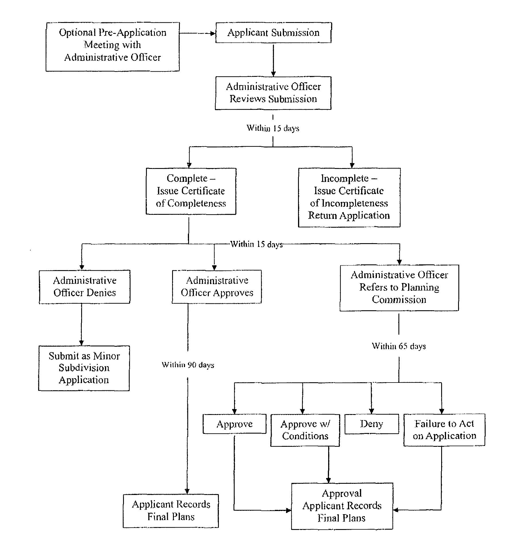
ARTICLE VII
Minor Subdivision and Land Development
§ 701. Minor Subdivision and Land Development.
A. Minor Subdivision. A minor subdivision is a plan for the subdivision of land into three or fewer residential lots, provided that the subdivision does not require any waivers from, or modifications to, these Regulations, and also provided that:
1. No part of the land to be subdivided shall have been subdivided within five years prior to the submission;
2. No part of contiguously commonly owned land shall have been subdivided within five years prior to submission. The term "commonly owned" shall mean owned at the time of submission or at any time within five years prior thereto by the present owner or by any member of the owner's present family or any corporation or partnership in which the owner or the owner's immediate family has or had an interest; and
3. A covenant be executed and recorded with the plat stating that the subdivision and contiguous commonly owned lands will not be further subdivided within five years after final approval of the subdivision.
B. Minor Land Development. A minor land development is a development plan for a project of three or fewer residential lots or units, provided such development does not require waivers or modifications as specified in these Regulations. All non-residential land development projects shall be considered as major land development plans.
C. Submission Requirements. Any applicant requiring approval of a minor subdivision or land development shall submit to the Administrative Officer the plans and supporting materials required for the appropriate stage of review in the checklists contained in Appendix B of these Regulations.
Note: Checklist is included as an attachment to this chapter.
§ 702. Review Procedure.
A. Review Stages. Minor plan review consists of two stages: preliminary, and final. A pre- application meeting may also be held. If a street creation or extension is proposed, a public hearing is required. The Planning Board may vote to combine the approval stages, provided that requirements for all stages so combined have been met by the applicant to the satisfaction of the Planning Board.
B. Certificate of Completeness. The application shall be certified complete or incomplete by the Administrative Officer within 25 days of its receipt, or within 15 days if no street creation or extension is required. The time period will be deemed stopped upon the issuance of a certificate of incompleteness by the Administrative Officer, and will recommence upon the resubmission of a corrected application. However, in no event will the Administrative Officer be required to certify a corrected submission as complete or incomplete less than 14 days after its resubmission.
C. Review by the Administrative Officer. The Administrative Officer shall review the preliminary plan application and shall comment and make recommendations to the Planning Board, or Technical Review Committee if one has been appointed. The application shall be referred to the Planning Board for their decision on the application.
D. Technical Review Committee. The Technical Review Committee, if one has been appointed, may review the preliminary plan application and make recommendations to the Planning Board. When reviewed by the Technical Review Committee:
1. If the subdivision or land development plan is approved by a majority vote of the committee members, the application is forwarded to the Planning Board with a recommendation for preliminary plan approval without further review; or,
2. If the plan is not approved by a majority vote of the committee members, the application is referred to the Planning Board for their decision on the application.
E. Reassignment to Major Review. The Planning Board may re-assign a proposed minor subdivision or land development project to major review when the Planning Board is unable to make the positive findings required by § 307 of these Regulations. In that case, all submittal and review procedures for a major subdivision or major land development project shall be followed.
§ 703. Planning Board Decision.
A. No Street Creation or Extension. If no street extension or creation is required, the Planning Board shall approve, deny, or approve with conditions the preliminary plan within 65 days of the certification of completeness issued by the Administrative Officer. An extension of time, to be made part of the permanent record of the development application, may be agreed to by the applicant and the Board.
B. Street Creation or Extension Required. If a street extension or creation is required, the Planning Board shall hold a public hearing according to the requirements of § 303, and approve, deny, or approve with conditions the preliminary plan within 95 days of the certification of completeness issued by the Administrative Officer. An extension of time, to be made part of the permanent record of the development application, may be agreed to by the applicant and the Board.
C. Inaction by Planning Board. Failure of the Planning Board to act within the period specified shall constitute approval of the preliminary plan, in which case a certificate from the Administrative Officer as to the failure of the Planning Board to act within the required time period, and the resulting approval, shall be issued on request of the applicant.
D. Final Plan. Materials required for final plan review shall include any requirements set forth by the Planning Board during the preliminary plan review, in addition to those required by the appropriate checklist. This phase is intended to be ministerial in nature, to ensure that all necessary changes to plans have been made and required documentation has been submitted. The Planning Board may delegate final plan review and approval to either the Administrative Officer or the Technical Review Committee, who shall report its actions, in writing, to the Planning Board at its next regular meeting, to be made part of the permanent record.
E. Expiration of Approval. Approval of a minor subdivision or land development project shall expire 90 days from the date of final approval unless, within such time period, a plat or plan in conformity with such approval and as required by these Regulations, is submitted for signature and recording. Validity may be extended for a longer period for cause shown, if requested by the applicant in writing no less than 30 days prior to the date of expiration, and if approved by the Planning Board.
FIGURE 1 ADMINISTRATIVE SUBDIVISION FLOWCHART
FIGURE 2
MINOR SUBDIVISION AND LAND DEVELOPMENT FLOWCHART
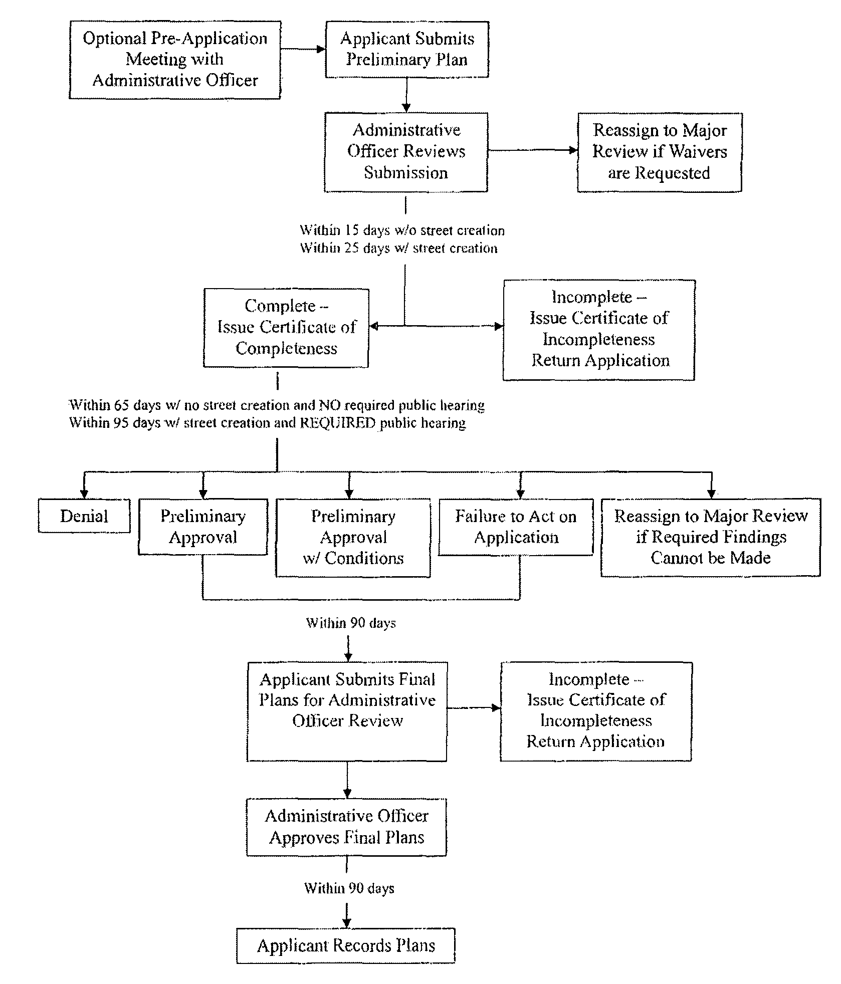
ARTICLE VIII
Major Subdivision and Land Development
§ 801. Major Subdivision and Land Development.
A. Major Subdivision. A major subdivision is any subdivision not classified as either an administrative subdivision or a minor subdivision.
B. Major Land Development. A major land development is any land development plan not classified as a minor land development plan, and any land development project that includes non-residential development.
C. Submission Requirements. Any application requiring approval of a major subdivision or land development project shall submit to the Administrative Officer the plans and supporting materials required for the appropriate stage of review in the checklists contained in Appendix C of these Regulations.
Note: Appendix C is included as an attachment to this chapter.
§ 802. General Review Procedures.
A. Review Stages. Major plan review shall consist of four stages: pre-application, master plan, preliminary plan and final plan. Also required is a public informational meeting (master plan stage), and a public hearing (preliminary plan stage). The Planning Board may vote to combine review stages and to modify and/or waive certain submission requirements. Review stages may be combined only after the Planning Board determines that all necessary requirements (material, fees, notice, etc.) for all stages so combined have been met by the applicant.
B. Pre-Application Procedures. The procedures and criteria for pre-application meetings and concept review, as described in § 302 these Regulations, shall apply. At the conclusion of the pre-application stage, the applicant may proceed to the master plan stage of review.
C. Technical Review Committee. At each stage of the project review, the Technical Review Committee, if one has been appointed, shall review the application and shall comment and make recommendations to the Planning Board.
D. Inaction by Planning Board. Failure of the Planning Board to act within the period specified at any stage of the application shall constitute approval of the plan at that stage, in which case a certificate from the Administrative Officer as to the failure of the Planning Board to act within the required time period, and the resulting approval, shall be issued on request of the applicant.
§ 803. Master Plan Review Procedures.
A. Purpose. The purpose of the master plan stage of review is to provide the applicant with the opportunity to present an overall plan for a proposed project site outlining general, rather than detailed, development intentions. The master plan describes the basic parameters of a major development proposal, rather than giving full engineering details.
B. Initial Written Comments. Initial comments on the master plan shall be solicited from town department and agencies, state agencies, and federal agencies, as required in the master plan checklist (Appendix C). The Administrative Officer shall coordinate review and comments by participating agencies.
C. Certificate of Completeness. The application shall be certified complete or incomplete by the Administrative Officer within 60 days of its receipt. The time period will be deemed stopped upon the issuance of a certificate of incompleteness by the Administrative Officer, and will recommence upon the resubmission of a corrected application. However, in no event will the Administrative Officer be required to certify a corrected submission as complete or incomplete less than 14 days after its resubmission.
D. Informational Meeting. A public informational meeting shall be held prior to the Planning Board decision on the master plan, unless the master plan and preliminary plan approvals are being combined, in which case the public informational meeting shall be optional, based on Planning Board findings and determinations made part of the record.
1. Public Notice for the informational meeting is required, and shall be given at least 14 days prior to the date of the meeting in a newspaper of general circulation within the Town. Postcard notice shall be mailed by the applicant to all property owners requiring notice pursuant to § 303B.
2. At the public informational meeting the applicant, or any representative of the applicant, shall present the proposed development project for the benefit of the Planning Board and the public. The Planning Board shall allow oral and written comment from the general public. All public comments shall be made part of the public record of the application.
§ 804. Planning Board Decision — Master Plan.
E. Decision. The Planning Board shall, within 120 days of certification of completeness of the master plan application, or within such further time as may be consented to by the applicant, approve of the master plan as submitted, approve with changes and/or conditions, or deny the application.
F. Expiration of Master Plan Approval. Approval of a master plan for a major subdivision or land development project shall expire two years from the date of approval. Vesting may be extended for a period of two additional years for good cause shown, if requested by the applicant in writing no less than 30 days prior to the date of expiration, and if approved by the Planning Board. The applicant, or the applicant's representative, shall appear before the Planning Board for the annual review. Master plan vesting shall include any applicable provisions of the Zoning Ordinance that were in place at the time of approval, conceptual layout and all conditions shown on the approved master plan drawings and supporting materials.
§ 805. Preliminary Plan Review Procedures.
A. Final Written Comments. At the preliminary plan stage, the Administrative Officer shall solicit final written comments from all town departments, staff, boards and commissions, and all authorities, as appropriate, as required in the preliminary plan checklist (Appendix C).
B. Certificate of Completeness. The application shall be certified complete or incomplete by the Administrative Officer within 60 days of its receipt according to the provisions of these Regulations.
C. Public Hearing. Prior to a Planning Board decision on the preliminary plan, a public hearing shall be held, as described in § 303 of these Regulations.
D. Public Improvement Guarantees. Proposed arrangements for completion of the required public improvements, including construction schedule and/or financial guarantees, shall be reviewed and approved by the Planning Board at the time of preliminary plan approval.
§ 806. Planning Board Decision — Preliminary Plan.
A. Decision. The Planning Board shall, within 120 days of certification of completeness of the preliminary plan application, or within such further time as may be consented to by the applicant, approve of the preliminary plan as submitted, approve it with changes and/or conditions, or deny the application.
B. Expiration of Preliminary Plan Approval. Approval of a preliminary plan for a major subdivision or land development project shall expire two years from the date of approval. Vesting may be extended for a period of two additional years for good cause shown, if requested in writing no less than 30 days prior to the expiration of the approval, and if approved by the Planning Board. The vesting for the preliminary plan approval shall include all general and specific conditions as shown on the approved preliminary plan drawings and supporting material.
§ 807. Final Plan Review Procedures.
A. Final Plan Submission. Materials required for final plan review shall include any requirements set forth by the Planning Board during the preliminary plan review, in addition to those required by the appropriate checklist (Appendix C).
B. Certificate of Completeness. The application for final plan approval shall be certified complete or incomplete by the Administrative Officer within 25 days of its receipt, according to the provisions of these Regulations. This time period may be extended to 45 days by written notice from the Administrative Officer to the applicant where the final plans contain changes to or elements not included in the preliminary plan approval.
§ 808. Planning Board Decision — Final Plan.
A. Decision. The Planning Board shall, within 45 days of certification of completeness of the final plan application, or within such further time as may be consented to by the applicant, approve or deny the final plan as submitted. The Planning Board may delegate final plan review to the Administrative Officer. If the Administrative Officer determines that the application for final plan approval meets the requirements of these Regulations and those set by the Planning Board as a condition of preliminary approval, and certifies the application as complete, the final plan shall be considered approved.
The Administrative Officer shall report his or her actions, in writing, to the Planning Board at its next regular meeting, to be made part of the permanent record.
B. Expiration of Final Plan Approval. The final plan of a major subdivision or land development project shall expire one year from the date of approval by the Planning Board unless, within that time period, the plat or plan shall have been submitted for signature and recording. The Planning Board may, for good cause shown, extend the period for recording for an additional one year, if requested by the applicant in writing no less than 30 days prior to the expiration of the approval.
FIGURE 3
MAJOR SUBDIVISION AND LAND DEVELOPMENT FLOWCHART
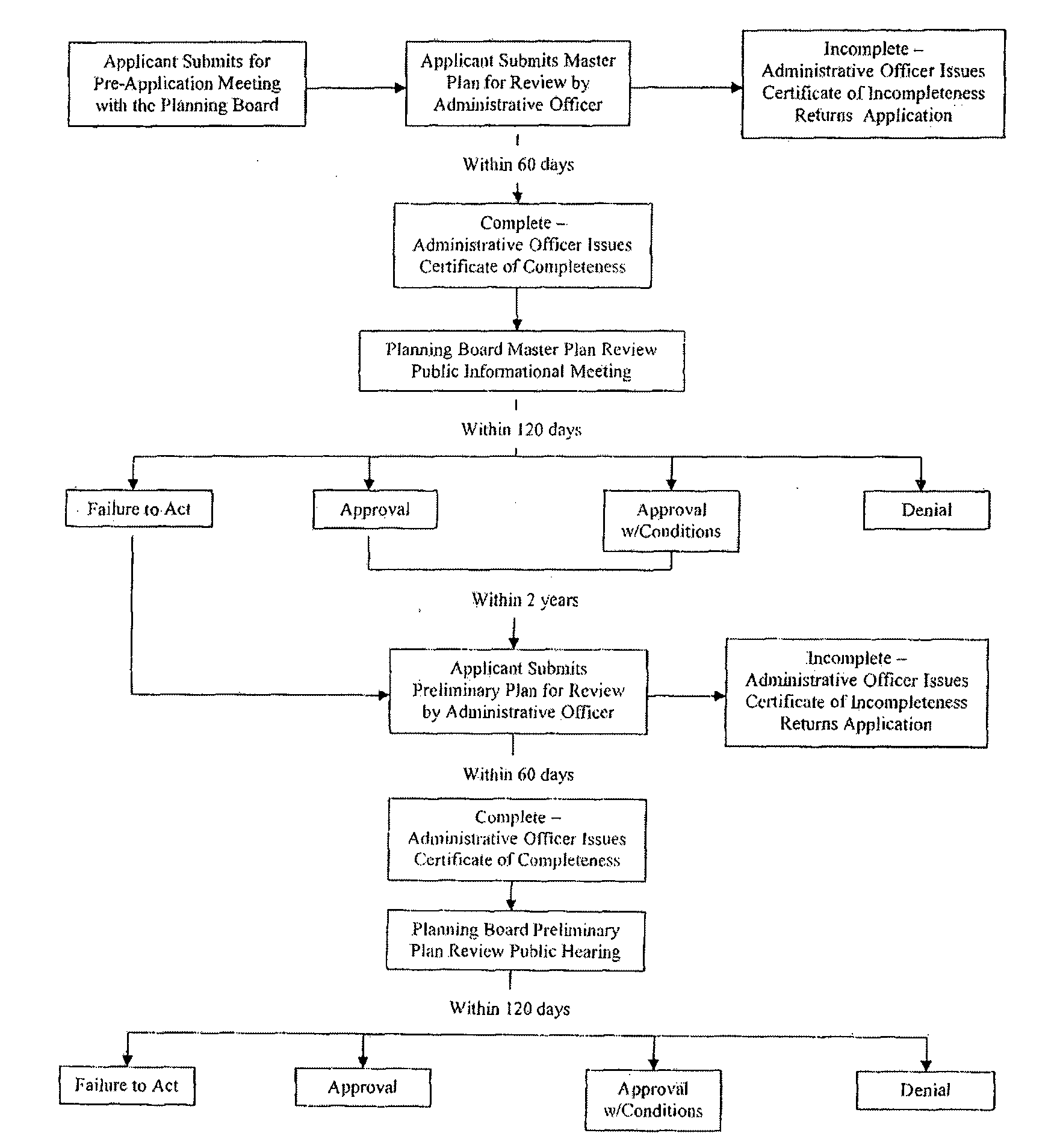
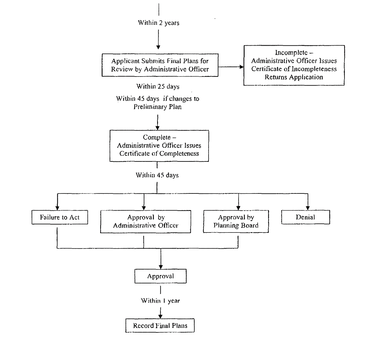
ARTICLE IX
Public Improvement Guarantees and Recording of Plans and Plats
§ 901. Guarantees of Public Improvements.
A. Definition. An improvement guarantee is a security instrument accepted by the Town to ensure that all improvements, facilities or work required by these Regulations or as a condition of approval of a land development or subdivision plan by the Planning Board, will be completed in compliance with the approved plans and specifications.
B. Purpose. Improvement guarantees shall be provided to ensure the proper installation and maintenance of required street, utility and other physical improvements, and to ensure compliance with other nonstructural conditions of final plat approval (if any). The nature and duration of the guarantee shall be structured to achieve this goal without adding unnecessary costs to the developer or subdivider.
§ 902. Procedures for Completion of Improvements.
A. General Procedures. Before any land development or subdivision plan is endorsed by the Planning Board, and before the recording of any subdivision plats, the Planning Board shall be required to approve agreements for the completion of all required improvements. Such agreements may, at the option of the developer or subdivider, take the form of:
1. Completion of actual construction of all improvements;
2. Improvement guarantees; or
3. A combination thereof.
B. Private Improvements. Streets constructed as part of a development or subdivision which are to be privately owned may be covered by an improvement guarantee. However, other improvements which are proposed to be privately owned and maintained, such as but not limited to, utilities and drainage systems, may not be covered by an improvement guarantee, but must be constructed prior to recording.
C. Developer's Intent. At the preliminary review stage, the developer shall submit either of the following:
1. A letter to the Planning Board indicating an intent to complete the required improvements prior to the Planning Board's endorsement of the final plan; or
2. A letter requesting that security sufficient to cover the cost of required improvements be established by the Board.
D. Improvements Constructed Prior to Final Plan Approval. If improvements are to be constructed without a financial guarantee, all work shall be completed prior to endorsement and recording. Inspections shall be made by the designated personnel at all required stages of construction. All construction shall be inspected and approved under the direction of the Administrative Officer and according to any adopted procedures. Upon completion of all required improvements, the Administrative Officer shall certify such completion to the Planning Board in writing. A copy shall be provided to the developer or subdivider upon request. The final plan shall be endorsed by the appropriate Planning Board or town official and the plat shall be recorded as provided herein, at which time the lots within the subdivision may be transferred or sold.
E. Improvements Constructed After Final Plan Approval. If improvements are to be guaranteed, the provisions in § 903 below shall apply.
§ 903. Improvement Guarantees.
A. Amount. Improvement guarantees shall be in an amount and with all necessary conditions to secure for the Town the actual construction and complete installation of all of the required improvements, and the satisfactory completion of all conditions of final approval within the time periods required for completion. The amount shall be based upon actual cost estimates which would be required for the Town to complete all improvements required as a condition of final approval. These estimates shall be initially prepared by the Director of Public Works and submitted to the Administrative Officer, who shall review the estimates, if requested, with the developer. If the developer disagrees with the estimated amount, the developer shall have the opportunity to submit a revised estimate along with supporting justification for the revisions. The Technical Review Committee, if constituted, shall review the Town's amount of the improvement guarantee and the developer's revision, and make a recommendation to the Planning Board. The Planning Board shall review and approve the final amount. The Board may set the guarantee in a reasonable amount in excess of the estimated costs in order to anticipate increases in economic or construction conditions. However, the amount of such increase shall not exceed 120% of the estimated cost of improvements as recommended by the Town.
B. Status of Improvements. If, at the expiration of the final plan approval period, all required improvements are not complete, the Planning Board shall review the status of improvements and may:
1. Require the developer to extend the duration of the entire improvement guarantee;
2. Reduce the amount of the improvement guarantee to cover the estimated costs of remaining improvements; or
3. Authorize the Administrative Officer to take the steps necessary to ensure completion of the remaining work by using improvement guarantee funds.
C. Use of Funds. If at any time during the guarantee period the procedures, implementation measures, methods, materials and/or schedules of construction are determined by the Planning Board not to be in compliance with the approved plans, the Board may, after proper notification to the developer, authorize the use of improvement guarantee funds to insure proper compliance.
D. Releases. At the expiration of the final plan approval period, if all required improvements are complete, any improvement guarantee shall be returned to the developer. Partial releases or reductions in the guarantee amount may also be authorized at any time prior to the expiration of final approval. A written request for release or reduction of any improvement guarantees shall be made to the Administrative Officer, who shall refer such request to the Planning Board. After inspection of all required improvements, the Administrative Officer shall recommend that the Planning Board:
1. Authorize the Town to return all improvement guarantees to the developer;
2. Reduce the amount of the guarantee being held by the Town to cover the estimated cost of remaining improvements; or
3. Take no action until all required improvements are completed according to the approved plans.
E. Phased Developments or Subdivisions. In the case of land development projects or subdivisions which are approved and constructed in phases, the Planning Board shall specify improvement guarantees related to each particular phase. If any off-site improvements or other improvements or conditions which are not directly related to a particular phase are required as a condition of approval, the Board shall, in setting the guarantee amount for each phase, clearly specify when such guarantees are to be provided.
§ 904. Required Forms of Guarantees.
An improvement guarantee shall be in the form of a financial instrument acceptable to the Town Manager and shall be accessible to the Town at such time when use of such funds is authorized. Performance and maintenance guarantees may be provided by a variety of means including, but not limited to, the following:
A. Security Bond. The developer may obtain a security bond from a surety bonding company authorized to do business in the State of Rhode Island.
B. Letter of Credit. The developer may provide an irrevocable letter of credit from a bank or other reputable institution.
C. Escrow Account. The developer may deposit cash, or other instruments readily convertible into cash at face value, either with the Town or in escrow with a bank.
§ 905. Maintenance Guarantees.
A. Maintenance Guarantees — Amount. The Planning Board shall require that a maintenance guarantee be provided by the developer for all improvements which are being dedicated to the Town for public acceptance and maintenance. The amount of the maintenance guarantee shall be 5% of the original performance bond or other original guarantee amount. In the absence of such a guarantee, 5% of the total estimated cost of all required improvements shall be required.
B. Maintenance Guarantees — Period. The initial period for such maintenance guarantee shall be one year. At the end of the one year maintenance period, the Administrative Officer shall inspect all improvements subject to the guarantee and shall certify in writing to the Planning Board as to their condition. If found to be unacceptable, the Administrative Officer shall recommend an extension of the guarantee period to the Planning Board, and the original funds shall not be returned to the developer. If public improvements are in good condition and have not been damaged due to the fault of the developer, or through faulty workmanship or design, the maintenance guarantee shall be returned to the developer. In cases where the Planning Board finds there are extenuating circumstances, the initial maintenance period may be established for a period longer than one year. The reasons for establishing a longer maintenance period and the nature of the extenuating circumstances shall be made a part of the record.
§ 906. Acceptance of Improvements.
A. Conveyance of Improvements. Upon completion of all required improvements, the developer shall convey all public improvements to the Town for ownership and maintenance. Private facilities, such as private roads and open space and privately maintained drainage systems, shall not be conveyed to the Town.
B. Developer Responsibility. The developer shall first request that the Administrative Officer conduct a final inspection. The Administrative Officer shall certify to the Planning Board in writing that all required improvements have been satisfactorily completed. The applicant shall also request in writing, to the Administrative Officer, that public improvements, streets, land, easements or other facilities which were proposed in the plan and approved to be dedicated to the Town, be accepted by the Town. This request shall contain a description of all facilities to be accepted and shall be accompanied by an accurate description of all streets, easements, land or other facilities by metes and bounds and by reference to the final plan, and by a warranty deed transferring ownership to the Town and describing any special conditions or other requirements.
C. Town Acceptance. Upon certification of completion of all required improvements, and upon receipt of all required information from the applicant, the Administrative Officer shall place the request for acceptance upon the next available agenda of the Planning Board. If all requirements of these Regulations have been met by the applicant, the Planning Board shall recommend acceptance by the Town Council of all such improvements and shall transmit such recommendation to the Town Council in writing. In such recommendation for acceptance by the Town Council, the Planning Board shall also recommend an amount for a maintenance bond in accordance with these Regulations and shall recommend to the Town Council that no public improvements or facilities be accepted for ownership and maintenance until such maintenance bond has been submitted as required herein. Upon their acceptance by the Town Council, all improvements shall be permanently owned and maintained by the Town as part of the municipal system and the developer shall be no longer responsible for their care, repair or maintenance.
§ 907. Recording of Plans and Plats.
A. Procedures. Prior to Recording Prior to the recording of any plan or plat in the Land Evidence Records of the Town of New Shoreham, they shall be endorsed as described herein. No endorsement of plans and plats shall be made until one of the following has occurred:
1. The Administrative Officer has certified, in writing, that all of the required improvements have been made; or
2. The Town Manager has certified, in writing, that acceptable improvement guarantees have been received in accordance with these Regulations.
B. Endorsements. A mylar copy, in permanent, indelible, non-erasable ink, of all approved final plans and plats for land development and subdivision projects shall be signed by the appropriate Planning Board official as an indication of final approval. All endorsements shall reflect the authority of the signatory, and include the date of such endorsement.
1. Administrative and Minor Plans. Plans and plats for administrative subdivisions, minor subdivisions and minor land developments shall be signed by the Planning Board Chair or Vice-Chair, or if authority is delegated by a majority vote of the Board at the time final approval is rendered, by the Administrative Officer.
2. Major Plans. Plans and plats for major subdivisions and land developments shall be signed by the Planning Board Chair, or in the absence of the Chair, the Vice- Chair.
C. Recording. Provisions for the recording and permanent record keeping of all approved plans and plats, legal documents, and other materials and plans are as follows:
1. Upon endorsement, all plans and plats shall be submitted to the Administrative Officer prior to recording and filing in the Land Evidence Records of the Town. The material to be recorded shall include all plat drawings, homeowners' association documents, maintenance agreements, easement deeds and other pertinent information as indicated on the appropriate final plat checklist. A copy of the written decision of the Planning Board, signed by the appropriate Planning Board official, including all conditions of approval, shall also be recorded. No plans, plats, or supporting materials shall be recorded until the Administrative Officer has certified, in writing, that all required materials have been properly submitted and that all required fees have been paid.
2. Other parts of the application record for subdivisions and land development projects, including all meeting records, approved master plan and preliminary plan material, site analyses, environmental impact statements, all legal agreements, records of the public hearing and the entire final set of drawings as approved, shall be kept permanently by the town departments responsible for implementation and enforcement. One copy shall be kept on file by the Planning Board.
3. Construction drawings need not be recorded. However, a complete blueline or photocopy set of construction drawings, including street plans and profiles, cross sections, grading plans, drainage plans, landscaping plans, soil erosion and sediment control plans, utility plans and any other construction plans, details and specifications required as a condition of approval shall be filed with the Administrative Officer prior to recording. One copy of all construction drawings shall also be kept by the Building Official.
4. The Administrative Officer shall provide the "911" officials with the information required by those officials.
§ 908. Changes to Approved Plans and Plats.
A. General. For all changes to the approved plans of any land development project or subdivision subject to these Regulations, an amendment of the final development plans shall be required prior to the issuance of any building permits for any construction upon the subject property. Any changes approved to a recorded final plan shall be recorded as amendments to the final plan, in accordance with the procedures for recording of plats and plans as provided in these Regulations.
B. Procedure. Changes to a land development or subdivision plan may be approved as follows:
1. Minor Changes. Minor changes, as defined in these Regulations, to a land development or subdivision plan may be approved administratively, by the Administrative Officer, whereupon a permit may be issued. The changes may be authorized without additional public hearings, at the discretion of the Administrative Officer. All changes shall be made part of the permanent record of the project application. This provision does not prohibit the Administrative Officer from requesting a recommendation from either the Technical Review Committee or the Planning Board. Denial of the proposed change(s) shall be referred to the Planning Board for review as a major change.
2. Major Changes. Major changes, as defined in these Regulations, to a land development or subdivision plan may be approved only by the Planning Board, and must follow the same review and public hearing process required for approval of preliminary plans.
C. Applicability. This procedure shall apply to all changes including, but not limited to, changes in lot lines; changes to utility plans, grading plans or construction plans; modifications required by outside permitting agencies such as RIDEM or CRMC; changes which would have the effect of increasing the potential number of dwelling units or lots; and changes which conflict with uses or activities permitted by the Zoning Ordinance.
ARTICLE X
Design, Construction and Improvement Standards
§ 1001. Developer Expense.
The subdivider, or developer, shall bear all expenses, and shall construct all improvements, where required by the Planning Board in granting approval for any subdivision or land development project subject to these Regulations. Performance and maintenance guarantees shall be required for the construction and on-going maintenance and repair of all public improvements according to the provisions of Article 9.
§ 1002. General Site Design Standards.
A. Subdivision design and construction should maintain the present rural character of the island. It shall minimize ground disturbance, follow existing land contours, preserve large trees and other natural features, preserve stone walls and other cultural features, and protect ponds, wetlands, the island's sole source aquifer and other areas of critical concern as they may be identified in the New Shoreham Comprehensive Plan. Efforts shall be made to incorporate such features into the development, including use of stone walls as lot lines or other boundaries.
B. Subdivision design and siting of structures shall not have an adverse impact on ridge lines and significant public viewsheds, particularly those identified in the New Shoreham Comprehensive Plan, as amended; see Viewshed Map in Appendix D of these Regulations. The Planning Board may require that development be constructed into hillsides rather than on hilltops in order to preserve views and vistas which the Town deems important or significant.
Note: Appendix D is included as an attachment to this chapter.
C. Streets should, except in particularly high traffic areas, be of a permeable surface and all subdivision streets are to be owned and maintained by the private landowners serviced by the street. Public ownership of streets is not encouraged.
D. All utilities, including transmission lines, pipes, and pumping stations, are to be placed underground, unless waived by the Planning Board due to design, installation or maintenance considerations.
E. Bicycle paths, pedestrian walkways and greenways shall be incorporated into the proposed subdivision where appropriate to connect and intersect with similar existing or proposed facilities.
§ 1003. Site Analysis.
A. Site Analysis Required. An analysis of the subdivision site and nearby areas shall be required by the Planning Board for all major subdivisions. The scope and content of this analysis shall be discussed during any pre-application meeting and shall be presented by the subdivider or developer during the master plan stage of review. Similar analysis may be required by the Planning Board for any minor subdivision if the Board finds that the proposed development may have a negative impact on the existing natural and built environment or would be inappropriate for the character of the surrounding neighborhood.
B. Contents of Site Analysis. Site analysis shall identify the following specific areas to be preserved as undeveloped open space to the extent consistent with the reasonable utilization of land in accordance with applicable state and town regulations:
1. Unique or fragile ecological, cultural and visual areas, including fresh and saltwater wetlands, coastal features and significant public viewsheds;
2. Significant trees or stands of trees, or other vegetation that may be of particular horticultural or landscape value;
3. Lands in a floodplain, or subject to flooding, as designated on any federal or state flood maps depicting the property (See § 1013);
4. Steep slopes (15% or greater);
5. Habitats of endangered species, as identified on applicable federal and state listings;
6. Historically and archaeologically significant structures and sites, as listed on applicable federal or state lists; and
7. Agricultural lands.
§ 1004. Lot Design Standards.
A. General Standards. The Planning Board shall have the right to prohibit or require modification to lots which are shaped or configured in such a manner as to conflict with the use of the land for the intended purpose. Unusual shapes, angles and dimensions shall be avoided in lot layout and design. Additionally:
1. All lots shall meet the dimensional standards of the highest zone in which they are located, with Residential A (RA) being the highest and Service Commercial (SC) the lowest.
2. Water bodies, coastal and freshwater wetlands, and other areas not considered developable land (see § 304) shall not be used to fulfill the minimum lot area requirements for the zone in which the subdivision is located.
3. All side lot lines shall be as nearly at right angles to the street right-of-way as practicable or shall be radial in arrangement when the right-of-way is curved.
4. Lots shall, whenever possible, conform to existing field configurations, stone wall defined enclosures, or other pre-existing patterns and topography.
5. No lot shall have a ratio of average lot length to average lot width in excess of three to one.
6. All lots shall have direct access or right-of-way access to an existing public road.
B. Road Improvements. Where such existing public road has not been improved to the standards and specifications as required in these regulations, the Board may require the developer to make improvements to that part of the public road leading to the property being subdivided where necessary for drainage, safety, traffic or other reasons as deemed proper by the Board.
§ 1005. Easements.
Easements may be required by the Planning Board where necessary for the proper location and placement of improvements on private land as described below. The Board may, at its discretion, require the dedication of land to the Town in lieu of easements if such dedication would provide greater control over, and access to, the intended use. In addition to rights-of- way, easements may be required for the following purposes:
A. Water Course. Where a subdivision is traversed by a water course, drainage way or stream, there shall be provided a storm water easement or drainage right-of-way conforming substantially with the lines of such water course, and of such width as will be adequate for the purpose.
B. Sanitary Sewer. Within the sewer district, easements across lots or centered on rear or side lot lines may be provided for sanitary sewers. The nominal width for a sewer easement shall be 30 feet.
C. Drainage. Easements to install and maintain underground drainage facilities on private land may be required by the Planning Board. The nominal width for such a drainage easement shall be 20 feet.
D. Grading. The Planning Board may require the dedication of an easement to the Town in order to grade or to maintain grading on private property where such grading is necessary to establish or maintain adequate drainage, sight distances, or topographic features required as a condition of subdivision approval.
E. Utilities. Easements for water lines, electric and communication lines and other utilities may also be required. Whenever possible, utilities shall be grouped together and located within a right-of-way easement. All utility easements shall be a minimum width of 20 feet and contain, at least one concrete bound at each corner together with bounds at such other points as may be necessary to define the easement.
F. Sight Distance. Where deemed necessary by the Planning Board to establish or maintain adequate sight distances for vehicular traffic, the dedication of an easement to the Town may be required which would prohibit the erection or maintenance of any visual obstruction such as a structure, tree, shrub, wall, earthen embankment, hill or any other obstruction.
G. Bicycle or Pedestrian Access. Bicycle and pedestrian access shall be provided where required by the Planning Board to allow alternative connections to public roads, pathways, trails or other travelways on a separate strip of land dedicated to the Town, or on an easement having a minimum width of 15 feet.
H. Viewsheds. Easements for the protection of significant public viewsheds may be required to be delineated on plans and recorded in appropriate documents.
I. Other Easements. All other required easements, such as those for buffers, or no-cut zones, shall be of sufficient width and area for the intended purpose.
§ 1006. Street Design Standards.
The following design standards shall be applied in the creation, extension or improvement of a street as a result of any subdivision or land development project:
A. Topography and Lay-Out. The arrangement of streets shall be considered in relation to the existing street system, and topographic and natural conditions. The road system shall be designed to permit the safe, efficient and orderly movement of traffic; to meet, but not exceed, the needs of the present and future population; to have a simple and logical circulation pattern; to respect natural features and topography; and to create an attractive streetscape.
B. Access and Connectivity. In residential subdivisions, the road system shall be designed to serve the needs of the neighborhood and to discourage use by through traffic. However, in major subdivisions the Planning Board may require more than one means of vehicle access. Proposed streets within a major subdivision shall provide for their continuation or projection to join with principal streets on the perimeter of the subdivision or with adjacent vacant property in order that the streets may be extended at some future time. The reservation of strips of land preventing such access to adjoining property shall be prohibited. The Planning Board may require the provision of a temporary turn-around until such time as the adjacent tract is developed.
C. Ownership. Streets should be privately owned and maintained by the residents of the subdivision or development. When a road is privately owned and maintained, the owners have the responsibility to repair and maintain such road to the extent necessary to provide for safe vehicular travel by motor vehicles, including public safety and emergency vehicles. Any interpretation of the phrase "to the extent necessary to provide for safe vehicular travel" shall be made by the Planning Board. If the owners fail or refuse to repair and maintain the road, the Town may, in its discretion, undertake such repair and maintenance, following written notice to the property owners that it intends to do so. The Town may charge the owners of the lots with the reasonable costs of such repair and maintenance. Such charge shall be a lien on the lots enforceable and collectable by the Town in the same manner as property taxes.
D. General Design.
1. Street design shall provide adequate access for fire and rescue vehicles.
2. Streets shall be constructed with permeable surfaces to reduce run-off and facilitate natural drainage. Where hard surface paving is necessary by virtue of steep slopes (grade in excess of 10%) and difficult terrain, porous paving shall be used to the practical extent possible, with suitable drainage provided.
3. Street design shall ensure proper stabilization and drainage.
4. A landscape and planting plan may be required by the Planning Board.
5. Pedestrian walkways, greenways, bikeways and sidewalks may be required as part of the street design plan when deemed appropriate by the Planning Board.
6. Rigid geometric street patterns will not be permitted.
E. Dimensional Standards.
1. Street intersection center lines shall coincide precisely or be offset by at least 150 feet).
2. Street center lines shall intersect as nearly at right angles as practicable; no intersection shall contain an angle of less than 60°.
3. Streets of the proposed subdivision connecting to an existing paved street must be paved from the intersection to a distance of not less than 30 feet.
4. Cul-de-sac turnarounds and hammerheads shall, as a minimum, conform to the dimensional requirements and other specifications set forth in the Town of New Shoreham Utilities Standards — Section D.
5. Any easement or right-of-way to be used as a street shall, as a minimum, conform to the dimensional requirements and other specifications set forth in Table 1 below. Right-of-way width, pavement width, and surface material may vary depending on specific site conditions.
F. Lay-bys Required. Due to the width constraints of local roads, lay-by areas, which consist of a travel width of 20 feet for a length of 20 feet, shall be provided every 150 feet, or as determined by the Planning Board with consideration of available sight distances and site features and terrain.
G. Construction Standards. Construction of all streets shall conform to the specifications set forth in the Town of New Shoreham Utilities Standards — Section D.
H. Street Names. Every street shall have a name. An extension of an existing street shall have the same name as the existing street. Names of other proposed streets shall be substantially different from any existing street name in the Town of New Shoreham.
| Table 1 | |||
| Street Right of Way Standards | |||
| | Collector 20 to 50 homes | Local 11 to 20 homes | Local 10 or fewer homes |
| Right-of-Way Width | 30 feet | 30 feet | 20 feet |
| Shoulder Width | 5 feet each side | 6 feet each side | 4 feet each side |
| Travel Width | 20 feet | 18 feet | 10 feet |
| Overhead Clearance | 14 feet | 14 feet | 14 feet |
| Sidewalk | Yes1 | No | No |
| Roadway Construction | paved or gravel2 | gravel2 | gravel2 |
1 Design and construction to be determined by the Board
2 Gravel is not permitted where grades exceed 10%
§ 1007. Bounds.
Bounds (concrete or granite boundary markers) shall be paid for by the subdivider or developer and placed by a registered land surveyor on the street line at the beginning of all horizontal curves on both sides of each subdivision street, and shall not be more than 500 feet apart, at the corners of the subdivided parcel and on at least one corner of each subdivision lot. Monuments will be set four inches above finished grade of the center of the street.
§ 1008. Planting and Landscaping.
A. Landscape Plans. Where natural vegetation is determined by the Planning Board to be insufficient, the Board shall require the developer to design for their approval, and then execute, an appropriate landscape plan using materials which are native to Block Island. The Planning Board may also, where deemed appropriate, require screening in the form of a dense, 10 feet in width, evergreen buffer along the common boundary between residential and commercial developments. Landscaping shall not adversely impact significant views. When requested, landscaping plans shall include provisions for maintenance of any such plan.
B. Landscape Materials. Landscaping includes plant materials such as trees, shrubs, ground covers, grass and flowers, provided such plants are not invasive or potentially invasive species and are included in the Rhode Island Coastal Plant Guide developed by the University of Rhode Island College of the Environment and Life Sciences. The landscape plan may also incorporate other materials such as rocks, wetlands, paving materials, planters, signage and street furniture.
C. Landscape Areas. Areas which may be required to provide landscaping shall include, but are not necessarily limited to:
1. Drainage facilities, such as retention/detention basins or drainage swales;
2. Entrance features;
3. Open space areas;
4. Proposed recreation facilities;
5. Buffer areas;
6. Lot areas disturbed during construction or where extensive grading has removed a significant amount of vegetation;
7. Areas subject to re-grading or stabilization for soil erosion and sediment control purposes; and
8. Above ground utility boxes, pump stations and other such fixtures.
D. Process. If a landscape plan is required, the applicant shall be advised of this at the preliminary review stage of an administrative or minor subdivision and at the master plan stage of a major subdivision. Such landscape plan will be prepared by a registered landscape architect. It shall identify all existing and proposed landscape features, construction details as necessary, and a schedule for planting and completion.
§ 1009. Utilities.
A. Sanitary Sewers. Sanitary sewers shall be required in all subdivisions located within the Sewer District of the Town of New Shoreham and shall conform to the construction standards and specifications set forth in the Town of New Shoreham Utilities Standards Section A.
B. Public Water. Water stops shall be provided for each lot in subdivisions located within the area served by public water supply. Construction of any public water system shall conform to the specifications set forth in the Town of New Shoreham Utilities Standards Section B.
C. Fire Hydrants. Hydrants shall be installed in all subdivisions served by public water supply. Hydrant type, location and spacing shall meet the minimum requirements of the Block Island Water Company. Installation of hydrants shall meet the specifications set forth in the Town of New Shoreham Utilities Standards Section B.
D. Underground Installation. All utilities including wires, boxes, pipes and pump stations shall be placed underground. In cases where underground installation is not feasible for any reason, any alternate plan shall include the reasons installation is unfeasible and plans for mitigation of the effects of above ground installation and require specific approval by the Planning Board.
E. Onsite Wastewater Disposal. Where onsite wastewater treatment systems (OWTS) are proposed, no proposed building lot shall be designed and located in such a manner as to require approval under, or relief from, § 506 of the Zoning Ordinance. In addition, every proposed building lot must be capable of supporting its own water supply and OWTS sited on that lot, except in a Flexible Design Residential Development (See
§ 403).
§ 1010. Stormwater Management.
A. Stormwater Management System. The stormwater management system may be comprised of both structural and non-structural elements. Appropriate structural elements include the Best Management Practices (BMPs) described in the RI Stormwater Design and Installations Manual (RI Stormwater Manual) and the associated conveyance system. Low Impact Design (LID) site planning and design elements (see Subsection D below) that mitigate pollution, reduce sedimentation, provide visual amenities and provide wildlife habitat shall be utilized over structural elements, unless waived by the Planning Board due to the characteristics of the site and/or the proposed development, and based upon evidence submitted to the Planning Board by an appropriate professional (engineer, land surveyor, landscape architect).
B. Stormwater Calculation Methodology. Where a stormwater management plan and run- off calculations are required they shall be prepared by a registered professional engineer or landscape architect, as qualified. The stormwater calculations, runoff rates and system design shall be based upon the methods established in the RI Stormwater Manual.
C. Stormwater Management Requirements. The stormwater management plan shall further indicate how the following specific requirements will be met:
1. That each lot will be adequately drained;
2. That natural drainage patterns will be maintained whenever possible;
3. That all existing watercourses will be left open unless approval to enclose is granted by the Planning Board;
4. That all new open watercourses will be seeded or sodded, depending on grades and soil types;
5. That the water quality of any receiving water, particularly the salt pond, will be protected through use of BMPs;
6. That provisions for continuing future maintenance and repair shall be provided to, and approved by, the Planning Board; and
7. That all necessary easements to off-street watercourses will be obtained by the developer.
D. Design Requirements.
1. LID site planning and design strategies shall be used to the maximum extent practicable in order to reduce the generation of the water run-off volume, as follows:
a. Maximum protection of undisturbed open space in order to maintain pre- development hydrology and allow natural infiltration;
b. Maximum protection of natural drainage areas, streams, surface waters, wetlands and other regulated areas;
c. Minimize land disturbance, including clearing and grading, and avoid areas susceptible to erosion and sediment loss;
d. Minimize soil compaction and restore soils compacted as a result of construction activities;
e. Provide low maintenance, native vegetation that encourages retention and minimizes use of lawns, fertilizers and pesticides;
f. Minimize impervious surfaces;
g. Minimize the decrease in the time it takes run-off to travel from the hydraulically most distant point of the drainage area to the point of interest within a watershed;
h. Infiltrate precipitation as close as possible to the point it reaches the ground using vegetated conveyance and treatment systems;
i. Break-up or disconnect the flow of run-off over impervious surfaces; and
j. Provide source controls to prevent or minimize the use or exposure of pollutants into stormwater run-off at the site in order to prevent or minimize the release of those pollutants into the run-off.
2. Stormwater should be recharged within the same subwatershed to the maximum extent possible.
3. Open drainage and pipe conveyance systems must be designed to provide adequate passage for flows leading to, from and through stormwater management facilities for at least the peak flow from the ten-year twenty-four-hour Type III design storm event.
4. The proposed drainage system shall be designed to accommodate stormwater so that post construction conditions do not result in peak run-off increases in rate or volume from pre-construction conditions.
F. Constructions Standards. Where storm drainage systems are required, their construction and installation shall conform to the specifications set forth in the Town of New Shoreham Utilities Standards Section C.
§ 1011. Water Quality.
A. Stormwater Treatment. When the ultimate destination of stormwater run-off is a permanent natural body of water or wetland, the Planning Board shall require the subdivider or developer to treat the stormwater run-off flows with a variety of Best Management Practices (BMPs) to achieve substantial reduction in pollutant loads to maintain the water quality in the receiving waters. The developer will be required to conform to the current standards delineated in the RI Stormwater Manual.
B. Drinking Water Standards. Stormwater discharges to drinking water reservoirs and their tributaries, degraded water bodies and poorly flushed estuaries will require higher pollutant removal efficiencies to meet the state's anti-degradation policies and water quality regulations for water pollution control. Where required by the Planning Board, the subdivider or developer will be required to construct BMPs that achieve higher pollutant removal rates and mitigate potential detrimental effects to satisfy water quality goals.
C. Buffers. Buffers and setbacks from existing wetlands and water bodies, required or recommended by Rhode Island Department of Environmental Management (RIDEM) and the Rhode Island Coastal Resource Management Council (CRMC), as applicable, and the Town of New Shoreham, shall be incorporated into any plan and shall be strictly adhered to. Areas designated as buffer areas shall be described in terms of composition, use and maintenance.
1. Setback areas shall not be occupied by any structure or use unless specifically indicated on the plans approved by the Planning Board.
2. Where a brook or stream runs through the property there shall be a natural buffer of at least 20 feet on each side.
§ 1012. Erosion and Sediment Control.
A. Soil Erosion and Sediment Control Plan. Major land developments and major subdivisions shall submit a soil erosion and sediment control plan as required by the Town of New Shoreham Soil Erosion and Sediment Control Ordinance, adopted June 3, 1991, as amended. Unless required by the Planning Board, minor land developments, minor subdivisions and administrative subdivisions shall not be required to submit a soil erosion and sediment control plan if the land disturbing activity involved meets all of the following criteria:
1. Construction activity will not take place within 100 feet of any wetland or coastal feature;
2. Slopes at the site do not exceed 10%;
3. The total area of land disturbance does not exceed 2,000 square feet;
4. Proposed grading does not exceed two feet of cut or fill at any point; and
5. The grading does not involve a quantity of fill greater than 50 cubic yards.
B. Plan Preparation. The erosion and sediment control plan shall be prepared by a registered professional engineer or registered landscape architect.
C. Plan Contents. The erosion and sediment control plan shall include sufficient information to form a clear basis for discussion and review and to assure compliance with all applicable requirements of these Regulations. The plan shall be consistent with the data collection, analysis, and plan preparation guidelines in the current "Rhode Island Soil Erosion and Sediment Control Handbook" prepared by the US Department of Agriculture, Soil Conservation Service. At a minimum, the plan shall contain:
1. A narrative description, with supporting documentation and maps, describing the proposed land disturbing activity and the erosion and sediment control measures to be installed;
2. Construction drawings detailing all land disturbing activity including existing and proposed contours, cuts and fills, drainage features, vegetation, limits of clearing and grading, the location of erosion and sediment control and stormwater management measures, with detailed drawings of these measures, location of stockpiles and borrow areas, and the sequence and scheduling of construction; and
3. Any other information deemed necessary and required by the Planning Board.
D. Performance Principles. The erosion and sediment control plan shall clearly-meet the performance principles contained within the current version of the Town of New Shoreham Soil Erosion and Sediment Control Ordinance, except however, when related to the control of stormwater run-off, the stormwater management requirements and standards of these Regulations shall govern.
E. Maintenance of Measures. Maintenance of all erosion sediment control features under these Regulations shall be the responsibility of the developer. Watercourses originating and located completely on private property shall be the responsibility of the developer to their point of open discharge at the property line or at a communal watercourse within the property. If proper maintenance procedures are not followed, the Planning Board may authorize the Director of Public Works to take the steps necessary to ensure proper maintenance by using the guarantee funds as provided for in § 905.
F. Periodic Inspections. The Director of Public Works may require inspections at such intervals as he/she may deem necessary to ensure proper compliance with the approved erosion and sediment control plan. Copies of all inspection reports shall be available to the developer upon request.
§ 1013. Areas of Special Flood Hazard.
The Planning Board shall examine any proposed subdivision or land development to ensure that if any part of the subdivision or development is located within an area of special flood hazard as identified in the Federal Emergency Management Agency Flood Hazard Boundary Maps, adequate protection is provided against flood damage with respect to materials, utilities, design and construction.
§ 1014. Off-Site Improvements.
A. Purpose. This section is intended to ensure that the subdivider or developer provide off- site infrastructure improvements in order to mitigate the impacts which are directly or indirectly attributable to new development. Such improvements may be required by the Planning Board if the Board finds that there is a reasonable relationship between the requested improvement and the proposed new development. Off-site improvements may include, but are not limited to the following:
1. Sewer and water supply improvements (within districts served by public sewer and water);
2. Roadways and sidewalks;
3. Bicycle paths, pedestrian walkways and greenways; and
4. Drainage systems.
B. Definition and Principles. As a condition of any final approval, the Planning Board may require a subdivider or developer to construct reasonable and necessary improvements off of the land being subdivided or developed. Such improvements are those clearly and substantially related to the subdivision or land development being proposed. The Planning Board shall provide in its final approval the rationale for requiring such off- site improvements and must find that a significant negative impact on existing conditions will result if the improvements are not made. All required off-site improvements must reflect the character defined for that neighborhood or district by the New Shoreham Comprehensive Plan.
§ 1015. General Construction Procedures and Inspections.
The following procedures shall be followed in the construction of any subdivision or related improvement:
A. Pre-Construction Meeting. A pre-construction meeting shall be held with the Director of Public Works at least seven days prior to the start of construction. The subdivider or developer, or a duly authorized representative, and the on-site project manager or contractor shall attend.
B. Inspections. Inspections and approvals by the Director of Public Works shall be required as follows:
1. Following installation of all underground drainage structures, systems and utilities prior to back filling;
2. Following the preparations of road sub-grade and shoulders;
3. Following the application and compaction of road surfacing materials and, if required, the completion of sidewalks;
4. Following completion of all improvements and installation of bounds; and
5. At periodic intervals to ensure compliance with the erosion and sediment control plan.
C. Notice and Fees. The developer shall notify the Director of Public Works when the project is ready for each of the above required inspections. Inspection fees shall be paid as established in § 503.
D. As-Built Drawings. Upon completion of construction and all required improvements, and before the performance bond is released and the maintenance bond is accepted, the developer shall furnish one complete mylar set, five complete sets of blue line copies, and one complete set of 11 inches x 17 inches reductions of "as built" drawings of the completed project, as well as a digital file, to the Administrative Officer.
APPENDIX D
D Attachment 1
Town of New Shoreham
APPENDIX A
ADMINISTRATIVE SUBDIVISION CHECKLIST
Materials and information required for application. Specific items may be waived by the Planning Board on the recommendation of the Administrative Officer.
The applicant shall submit for the approval of the Administrative Officer at least 10 blueline or photocopies of the proposed plan of a scale sufficient to show all of the details required, no larger than 24 inches x 36 inches, together with two copies reduced to 11 inches x 17 inches.
At a minimum, the following information shall be provided:
| □ 1. | Name and address of property owner and applicant. |
| □ 2. | Date of plan, with revision dates, if any. |
| □ 3. | Graphic scale, true north arrow, and vicinity locus map. |
| □ 4. | A radius map showing all properties within 500 feet of the land being subdivided and the locations of all structures within 200 feet of the property line. |
| □ 5. | Plat and lot number(s) of the parcel(s) being re-subdivided, with identification of zoning district(s). |
| □ 6. | A separate listing, in or attached to the legend of the plan, of all streets on which the subject property abuts. |
| □ 7. | Perimeter boundary lines, drawn to distinguish them from other property lines. |
| □ 8. | All existing property lines with total acreage and buildable land calculations for each lot. |
| □ 9. | All proposed property lines with total acreage and buildable land calculations for each lot. |
| □ 10. | Location of existing and proposed streets, private lanes, pedestrian paths or walkways, rights-of-way, utilities, easements, stone walls, and other significant features. |
| □ 11. | Plan for relocating any above-ground utilities underground prior to any development. |
| □ 12. | Location of ponds, wetlands, and coastal features (if any), cemeteries, and sites of historic and archaeological importance. |
| □ 13. | Location and size of existing and proposed buildings and other structures. |
| □ 14. | Notation of any existing or proposed deed restrictions, including those related to land being proposed as open space. |
| □ 15. | A certificate from the Tax Collector affirming that all taxes have been paid and that there are no municipal liens on the parcel(s). |
| □ 16. | A certificate from the Building Official that there are no outstanding violations on the parcel(s). |
| □ 17. | Certification (stamp) of a registered land surveyor that the plan is correct. |
| □ 18. | Initial draft copies of all legal documents proposed to implement the plan, including all easements, rights-of-way, dedications, covenants and restrictions, homeowners associations, and maintenance agreements. |
| □ 19. | Filing fee. |
NEW SHOREHAM CODE
Following final approval, the applicant shall provide the following:
1. A permanent, indelible, nonerasable mylar for recording purposes.
2. A digital file indicating all property lines, rights-of-ways and easements as approved on the final plan.
APPENDIX D
D Attachment 2
Town of New Shoreham
APPENDIX B
MINOR SUBDIVISION AND MINOR LAND DEVELOPMENT PLAN CHECKLISTS
Materials and information required for pre-application meeting(s), preliminary and final plan review. Specific items may be waived by the Planning Board on the recommendation of the Administrative Officer.
A. PRE-APPLICATION MEETING(S). (Note: held only if requested by either the applicant or the Planning Board. If not held, proceed to preliminary stage.) The applicant shall submit for the approval of the Administrative Officer at least 10 copies of conceptual plans. These need not be certified (stamped) by a registered land surveyor but shall clearly provide, at a minimum, the following information:
| □ 1. | Name and address of property owner and applicant. |
| □ 2. | Date of plan, with revision dates, if any. |
| □ 3. | Graphic scale, true north arrow, and vicinity locus map. |
| □ 4. | A radius map showing all properties within 500 feet of the land being subdivided and the locations of all structures within 200 feet of the property line. |
| □ 5. | Plat and lot numbers of the parcel being subdivided, with identification of zoning district(s). |
| □ 6. | A separate listing, in or attached to the legend of the plan, of all streets on which the subject property abuts. |
| □ 7. | Perimeter boundary lines, drawn to distinguish them from other property lines. |
| □ 8. | All existing property lines. |
| □ 9. | All proposed property lines, and zoning setback lines (building envelope). |
| □ 10. | Location of existing and proposed streets, private lanes, pedestrian paths or walkways, rights-of-way, utilities, easements, stone walls, and other significant features. |
| □ 11. | Plans for relocating any above-ground utilities underground prior to any development. |
| □ 12. | Location of ponds, wetlands, and coastal features (if any), cemeteries, and sites of historic and archaeological importance. |
| □ 13. | Location and size of existing and proposed buildings and other structures. |
| □ 14. | Notation of any existing or proposed deed restrictions, including those related to land being proposed as open space. |
| □ 15. | Filing Fee. |
NEW SHOREHAM CODE
B. CHECKLIST REQUIREMENTS FOR PRELIMINARY PLAN.
The applicant shall submit for the approval of the Administrative Officer at least 10 blueline or photocopies of preliminary plans of a scale sufficient to show all of the details required, no larger than 24 inches x 36 inches, certified (stamped) by a registered land surveyor, together with two copies reduced to 11 inches x 17 inches. At a minimum, the following information shall be provided:
| □ 1. | All items 1 through 14 required for pre-application meeting (above). |
| □ 2. | Location of flagged wetland boundaries, watercourses and coastal features within the subject parcel and within 200 feet of the perimeter of the parcel, OR an affidavit signed by a qualified professional (wetlands biologist, registered professional engineer, registered professional land surveyor) stating that there are no such wetlands or coastal features. Wetlands, water courses and coastal features outside the parcel may be delineated through use of GIS mapping. |
| □ 3. | Base flood elevation date (where applicable). |
| □ 4. | Existing contours at intervals of five feet. |
| □ 5. | Locations, dimensions and materials of any existing or proposed retaining walls. |
| □ 6. | Total acreage and buildable land calculations for each proposed building lot. |
| □ 7. | Location, dimension and area of any land proposed to be set aside as open space. |
| □ 8. | Locations of existing and proposed permanent bounds. |
| □ 9. | Grading plan in sufficient detail to show proposed contours for all grading proposed for street construction, drainage facilities, and grading upon individual lots. |
| □ 10. | Proposed drainage plan and surface runoff calculations. |
| □ 11. | A landscaping plan, unless waived by the Planning Board. |
| □ 12. | Proposed utilities plan, including sewer, water, electric, phone, cable TV, as applicable. |
| □ 13. | If applicable, written confirmation by the Director of Public Works that adequate public water and sewer service will be available. |
| □ 14. | If onsite wastewater treatment systems are proposed, confirmation from the State Department of Environmental Management that the soils are adequate for the use of OWTS evidenced by water table verification. |
| □ 15. | A preliminary determination from the Coastal Resources Management Council, if applicable. |
| □ 16. | Written comments from the Technical Review Committee (provided by the Administrative Officer). |
| □ 17. | Written comments or advisories from the Historic District Commission and Conservation Commission, if applicable. |
| □ 18. | Either of the following: |
| | a) A letter to the Planning Board stating the subdivider’s intent to complete all required improvements prior to recording; |
| | b) A letter to the Planning Board requesting that security sufficient to cover the costs of required improvements be established by the Board. |
APPENDIX D
| □ 19. | A written request for any required waivers or modifications which shall include: the specific regulations from which relief is being sought; the reasons for the requested waivers or modifications; demonstration that the requests, if granted, are in the best interest of good planning practice and/or design and are consistent with the Comprehensive Plan and Zoning Ordinance. |
| □ 20. | Initial draft copies of all legal documents proposed to implement the plan, including all easements, rights-of-way, dedications, covenants and restrictions, homeowners associations, and maintenance agreements. |
| □ 21. | The names and addresses of all abutting property owners and copies of mail receipts and return receipts for certified mail notices. |
| □ 22. | Filing fee. |
NEW SHOREHAM CODE
C. CHECKLIST REQUIREMENTS FOR FINAL PLAN.
The applicant shall submit for the approval of the Administrative Officer at least 10 blueline or photocopies of final plans for all subdivision elements and improvements, no larger than 24 inches by 36 inches, certified (stamped) by a registered professional engineer, together with two copies reduced to 11 inches x 17 inches. Final plans shall reflect conditions of preliminary plan approval and, at a minimum, provide the following information:
| □ 1. | All items required for preliminary plan also applicable to the final plan. |
| □ 2. | If wetlands exist on the property, written confirmation from RIDEM that plans of the proposed development, including any required off-site construction, have been reviewed and that approval has been granted for the proposed site alteration. |
| □ 3. | If the property contains a coastal feature, written confirmation from CRMC that plans of the proposed development, including any required off-site construction, have been reviewed and that approval has been granted for the proposed site alteration, if wetlands exist on the property. |
| □ 4. | Soil erosion and sediment control plan (if required by the Planning Board). |
| □ 5. | Final drainage plans. |
| □ 6. | Final landscaping plans, if required. |
| □ 7. | Final copies, in recordable form and reviewed by the Town Solicitor, of all legal documents. |
| □ 8. | A certificate from the Tax Collector affirming that all taxes have been paid and that there are no municipal liens on the parcel(s). |
| □ 9. | Filing fee. |
| □ 10. | Payment of other required fees or posting of financial guarantees, if required, prior to final approval by the Planning Board and the recording of final plans: |
| | a) Final plat recording fees. |
| | b) Performance bond or other financial guarantees for construction and maintenance. Final plans shall reflect any additional improvements or changes requested by the Planning Board as conditions of approval. Following final approval, the applicant shall provide the following: |
| | 1. A permanent, indelible, nonerasable mylar for recording purposes. |
| | 2. A digital file indicating all property lines, rights-of-ways and easements as approved on the final plat. |
APPENDIX D
D Attachment 3
Town of New Shoreham
APPENDIX C.
MAJOR SUBDIVISION AND MAJOR LAND DEVELOPMENT PLAN CHECKLISTS
Materials and information required for pre-application meeting(s), master, preliminary and final plan review. Specific items may be waived by the Planning Board on the recommendation of the Administrative Officer.
A. PRE-APPLICATION MEETING(S).
The applicant shall submit for the approval of the Administrative Officer at least 10 copies of conceptual plans of a scale sufficient to clearly show all of the information required, no larger than 24 inches by 36 inches, certified (stamped) by a registered land surveyor. Additionally, the applicant shall submit two copies of all plans reduced to 11 inches by 17 inches. At a minimum, the following information shall be provided:
| □ 1. | Name of the proposed development. |
| □ 2. | Name and address of property owner and applicant. |
| □ 3. | Date of plan, with revision dates, if any |
| □ 4. | Graphic scale, true north arrow and vicinity locus map. |
| □ 5. | A radius map showing all properties within 500 feet of the land being subdivided and the locations of all structures within 200 feet of the property line. |
| □ 6. | Plat and lot numbers of the parcel being subdivided, with identification of zoning district(s). |
| □ 7. | A separate listing, in or attached to the legend of the plan, of all streets on which the subject property abuts. |
| □ 8. | Perimeter boundary lines, drawn to distinguish them from other property lines. |
| □ 9. | An aerial photograph of the proposed subdivision and surrounding area (available through GIS). |
| □ 10. | A soils map of the subdivision parcel and surrounding area (available through GIS) and a general analysis of soil types and suitability for development. |
| □ 11. | All existing property lines. |
| □ 12. | All proposed property lines, and zoning setback lines (building envelope). |
| □ 13. | Location of existing and proposed streets, private lanes, pedestrian paths or walkways, rights-of-way, utilities, easements, stone walls and other significant features. |
| □ 14. | Proposals, if any, for connection with public water and sewer systems. |
| □ 15. | Location of ponds, wetlands and coastal features (if any), cemeteries and sites of historic and archeological importance. |
| □ 16. | Approximately topography. |
| □ 17. | Location and size of existing and proposed buildings and other structures. |
| □ 18. | Notation of any existing or proposed deed restrictions, including those related to land being proposed as open space. |
NEW SHOREHAM CODE
| □ 19. | An estimate of the population of the proposed subdivision, including school age children. |
| □ 20. | A narrative report providing a general description of the existing physical environment and existing uses of the property along with a general description of the uses and type of development proposed by the applicant. |
| □ 21. | Filing Fee. |
B. CHECKLIST REQUIREMENTS FOR MASTER PLAN.
The applicant shall submit to the Administrative Officer at least 10 sets of blueline or photocopies of master plans no larger than 24 inches by 36 inches, certified (stamped) by a registered land surveyor and registered professional engineer, together with two copies reduced to 11 inches by 17 inches. Master plans shall reflect any changes resulting from the pre- application meetings and, at a minimum, provide the following information:
| □ 1. | Items 1 through 20 required for pre-application meeting, above. |
| □ 2. | Location of flagged wetland boundaries, watercourses and coastal features within the subject parcel and within 200 feet of the perimeter of the parcel, OR an affidavit signed by a qualified professional (wetlands biologist, registered professional engineer, registered professional land surveyor) stating that there are no such wetlands or coastal features. Wetlands, water courses and coastal features outside the parcel may be delineated through use of GIS mapping. |
| □ 3. | Base flood elevation date (where applicable). |
| □ 4. | Existing topography with minimum contour intervals of two feet. |
| □ 5. | Locations, dimensions and materials of any existing or proposed retaining walls. |
| □ 6. | Total acreage and buildable land calculations for each proposed building lot. |
| □ 7. | Location, dimension and area of any land proposed to be set aside as open space. |
| □ 8. | Grading plan in sufficient detail to show proposed contours for all grading proposed for street construction, drainage facilities, and grading upon individual lots. |
| □ 9. | Proposed drainage plan and surface runoff calculations. |
| □ 10. | A landscaping plan and open space use plan. |
| □ 11. | If requested by the Planning Board, a clipboard model built at a scale of one inch equals 40 feet and showing all buildings and improvements, together with walls, roadways, vegetation, ponds, wetlands and other natural features. |
| □ 12. | Proposed utilities plan, including sewer, water, electric, phone, cable TV, as applicable. |
| □ 13. | If applicable, written confirmation by the Director of Public Works that adequate public water and sewer service will be available. |
| □ 14. | If onsite wastewater treatment systems are proposed, confirmation from the State Department of Environmental Management that the soils are adequate for the use of OWTS evidenced by water table verification. |
| □ 15. | A preliminary determination from the Coastal Resources Management Council, if applicable. |
| □ 16. | A comprehensive fiscal impact statement estimating tax revenues to the Town |
APPENDIX D
| | together with probable demand for additional local government services (water, sewer, transfer facility, public safety) and other economic factors such as new employment opportunities, when requested by the Planning Board. |
| □ 17. | A comprehensive environmental impact statement detailing the likely impact of the development on groundwater, surface runoff, erosion, viewshed and scenic landscape values, traffic and public safety, when requested by the Planning Board. |
| □ 18. | A comprehensive traffic study prepared by a registered professional engineer, if required by the Planning Board. |
| □ 19. | Written comments from the Technical Review Committee (provided by the Administrative Officer). |
| □ 20. | Initial comments from other local officials and agencies: Town Manager, Public Works Director, Building Official, Block Island Power Company, Conservation Commission, Historic District Commission, Police Department, Fire Department and Town Solicitor. |
| □ 21. | A written request for any required waivers or modifications which shall include: the specific regulations from which relief is being sought; the reasons for the requested waivers or modifications; demonstration that the requests, if granted, are in the best interest of good planning practice and/or design and are consistent with the Comprehensive Plan and Zoning Ordinance. |
| □ 22. | Filing Fee. |
C. CHECKLIST REQUIREMENTS FOR PRELIMINARY PLAN.
The applicant shall submit to the Administrative Officer at least 10 sets of blueline or photocopies of preliminary plans no larger than 24 inches by 36 inches, certified (stamped) by a registered land surveyor and registered professional engineer, together with two copies reduced to 11 inches by 17 inches. Preliminary plans shall reflect conditions of master plan approval following the public informational meeting and, at a minimum, provide the following information:
| □ 1. | All items required for master plan also applicable to the preliminary plan. |
| □ 2. | Locations of existing and proposed permanent bounds. |
| □ 3. | If wetlands exist on the property, written confirmation from RIDEM that plans of the proposed development, including any required off-site construction, have been reviewed and that approval has been granted for the proposed site alteration. |
| □ 4. | If the property contains a coastal feature, written confirmation from CRMC that plans of the proposed development, including any required off-site construction, have been reviewed and that approval has been granted for the proposed site alteration, if wetlands exist on the property. |
| □ 5. | Final comments by the Technical Review Committee and all relevant local, state and federal agencies, boards and commissions. |
| □ 6. | Either of the following: |
| | a) A letter to the Planning Board stating the subdivider’s intent to complete all required improvements prior to recording; |
| | b) A letter to the Planning Board requesting that security sufficient to cover the costs of required improvements be established by the Board. |
NEW SHOREHAM CODE
| □ 7. | Initial draft copies of all legal documents proposed to implement the plan, including all easements, rights-of-way, dedications, covenants and restrictions, homeowners associations, and maintenance agreements. |
| □ 8. | The names and addresses of all abutting property owners, and copies of return receipts for certified mail notices. |
| □ 9. | Filing Fee. |
D. CHECKLIST REQUIREMENTS FOR FINAL PLAN.
The applicant shall submit for the approval of the Administrative Officer at least 10 blueline or photocopies of final plans for all subdivision elements and improvements, no larger than 24 inches by 36 inches, certified (stamped) by a registered professional engineer, together with two copies reduced to 11 inches by 17 inches. Final plans shall reflect conditions of preliminary plan approval following the public hearing and, at a minimum, provide the following information:
| □ 1. | All items required for preliminary plan also applicable to the final plan. |
| □ 2. | Erosion and sediment control plan. |
| □ 3. | Final drainage plans. |
| □ 4. | Final landscaping plans, if required. |
| □ 5. | Deed transferring land proposed for dedication to the Town or other qualified group or agency for open space purposes. |
| □ 6. | Final copies, in recordable form and reviewed by the Town Solicitor, of all legal documents. |
| □ 7. | Certificate from the Tax Collector that all taxes have been paid and there are no municipal liens on the property. |
| □ 8. | Filing Fee. |
| □ 9. | Payment of other required fees or posting of financial guarantees, if required, prior to final approval by the Planning Board and the recording of final plans: |
| | a) Final plat recording fees. |
| | b) Performance bond or other financial guarantees for construction and maintenance. |
Final plans shall reflect any additional improvements or changes requested by the Planning Board as conditions of approval. Following final approval, the applicant shall provide the following:
| □ 1. | A permanent, indelible, nonerasable mylar for recording purposes. |
| □ 2. | A digital file indicating all property lines, rights-of-ways and easements as approved on the final plat. |
APPENDIX D
D Attachment 4
Town of New Shoreham
APPENDIX D.
NEW SHOREHAM VIEWSHED MAP (RESERVED)
APPENDIX D
D Attachment 5
Town of New Shoreham
APPENDIX E
LIST OF AMENDMENTS TO LAND DEVELOPMENT AND SUBDIVISION REGULATIONS AS AMENDED ON JUNE 8, 2011
| October 12, 2011 | Section 403F.4 | Open Space Ownership and Management Standards |