ARTICLE 13 – DESIGN and IMPROVEMENT STANDARDS
13.1 General requirements
13.1.1 The improvements required by the Planning Board pursuant to these regulations shall be constructed at the expense of the applicant.
13.1.2 On any property for which a subdivision or land development application has been filed, no construction or improvement, including but not limited to clearing, grading, and removal of vegetation, shall take place until after final plan approval.
13.1.3 All subdivisions and land development projects shall have physical access to an existing improved public street. If the public street is not adequate to serve the traffic that will be generated by the new development, or if the public street does not provide adequate access for public safety vehicles, the Planning Board has the authority to require an applicant to make the necessary improvements to the public street at the applicant's expense.
13.1.4 If an applicant's property is connected to a public street by a private street or a private right of way:
a) In the master plan application for major subdivisions and land development projects, or in the preliminary plan application for minor subdivisions and land development projects, the applicant shall identify the owner or owners of the street or right of way and shall submit evidence that the owner or owners consent to the use of the street or right of way for the proposed development; and
b) If the street or right of way is not adequate to serve the traffic that will be generated by the new development, or if the street or right of way does not provide adequate access for public safety vehicles, the Planning Board has the authority to require an applicant to make the necessary improvements to the private street or right of way at his or her own expense.
13.1.5 A public or private street shall be created as a separate lot.
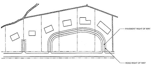
13.1.6 A common driveway that provides access to more than one property:
a) shall not be created as a separate lot,
b) shall not provide frontage for the property abutting it, and
c) shall be built according to the construction standards provided in these regulations.
13.1.7 Whenever these regulations require work to be done by a registered professional engineer, a registered land surveyor, or a registered landscape architect, the work shall be performed according to the standards established by the R.I. Board of Registration for Professional Engineers, the R.I. Board of Registration for Land Surveyors, and the R.I. Board of Registration for Landscape Architects.
13.1.8. An applicant who proposes the installation of public water shall provide written documentation as part of master plan application, or as part of the preliminary plan application for minor subdivision or land developments projects, that the public system is able to accommodate the additional demand.
13.2 Residential site design
The goal of these regulations is to promote functional and attractive development that minimizes environmental impacts and maintains the rural character of Richmond.
Low impact design principles, including maintaining natural drainage flow patterns, minimizing land clearance, clustering buildings, and minimizing impervious surfaces, shall be used to the greatest extent practicable. Developments shall be designed to avoid adversely affecting ground water and aquifer recharge, to reduce cut and fill, to avoid unnecessary impervious surfaces, to prevent flooding, to provide adequate access to lots and sites, and to mitigate adverse effects of shadow, traffic, drainage, and utilities on neighboring properties. To the greatest extent practicable, developments shall be designed to maintain or replicate the existing hydrology on the site through use of small-scale controls integrated throughout the site to manage runoff as near as possible to its source.
To assist the Planning Board in evaluating the features of the site and the applicant's proposed development of the site, the applicant shall submit the following site plans.
13.2.1 Site context plan
The applicant shall submit a Site Context Plan that shows the parcel to be developed and the property surrounding it, illustrating the relationship of the proposed development to nearby streams or wetlands; nearby streets, bicycle networks, and other transportation connections; nearby cultural features such as recreational facilities or open space; and land uses within one-half mile of the site.
13.2.2 Existing conditions and resources plan
The applicant shall submit an Existing Conditions and Resources Plan that shows, in detail, existing site conditions and existing natural, scenic and cultural features to show how the conditions and features relate to each other and how they can be protected. For major subdivisions and land developments, the plan shall show the site and all property within 500 feet of the site, and for minor subdivisions and land developments, the plan shall show the site and all property within 100 feet of the site. Conditions beyond the boundaries of the site may be described using data available from government agencies and aerial photographs.
The plan shall include the following:
a) Topography at two-foot intervals on the site and ten-foot intervals off the site. If the area is exceptionally steep or flat, the Administrative Officer may require the plan to show greater intervals or allow the plan to show lesser intervals. Places where the natural gradient is exceptionally steep shall be noted and the gradient shall be indicated. Ridge lines of existing hills shall be noted. The Administrative Officer may require the plan to show the boundaries of watersheds.
A professional land surveyor or registered professional engineer shall prepare the topography using a field survey or a stereoscopic aerial photography. The topography shall be coordinated with U.S.G.S. benchmarks.
b) The location of ponds, streams, ditches, drains, special aquatic sites, vernal pools, natural drainage swales, 100-year floodplains, freshwater wetlands, and wetland buffers required by State regulations. The edges of wetlands under the jurisdiction of the R.I. Department of Environmental Management must be verified by a professional wetland scientist.
c) The general types of vegetation present, including agricultural production, grassland or pasture, woodland, and swamp. Types of vegetation shall be described by plant community and condition. State Natural Heritage Program areas shall be noted.
d) Soil series as mapped by the U.S. Department of Agriculture, Natural Resources Conservation Service in the latest published soil survey for the State, and accompanying data published for each soil relating to its suitability for construction and its septic suitability.
e) Geologic formations including rock outcroppings, cliffs, kettle holes, and eskers as identified by published data or observation in the field.
f) Man-made features including streets, private roads, driveways, buildings, foundations, walls, wells, drainage fields, dumps, excavated areas, utilities, storm and sanitary sewers, and pedestrian, bicycle, or equestrian trails used by the public.
g) Sites or structures with historical significance including cemeteries, stone walls, cellar holes and foundations, and known archeological resources.
h) Easements and other relevant property encumbrances recorded in the land evidence records.
i) If requested by the Planning Board or the Administrative Officer, the location of viewsheds within the proposed development site, looking from the proposed development site toward adjacent property, or looking from adjacent property toward the proposed development site.
13.2.3 Development overlay plan
The applicant shall submit a Development Overlay Plan that shows the proposed development as an overlay to the Existing Conditions and Resources Plan. The Development Overlay Plan shall show the proposed location of open space, buildings, streets, and lot lines based on the following considerations:
13.2.3.1 Open space designation
The plan shall identify any open space to be preserved on the site. The most sensitive and noteworthy resources on the site should be located in the open space. Where feasible, the open space areas should connect to open spaces on surrounding property identified in the Comprehensive Community Plan. To the extent consistent with reasonable use of the land, the following areas shall be preserved as undeveloped open space:
a) Unique or fragile areas, including freshwater wetlands and vernal pools.
b) Significant trees or stands of trees, or other vegetative species that are rare or unusual or of particular botanical, horticultural or landscape value.
c) Floodplains.
d) Areas where the natural gradient exceeds 20% over ten feet.
e) Habitats of threatened or endangered wildlife, as identified on applicable federal or state lists, and other significant wildlife habitat such as vernal pools,
f) Historically or archeologically significant structures and sites, including any listed on the Federal or State list register of historic places, and
g) Prime farm land, as defined by the U.S. Department of Agriculture, Natural Resources Conservation Service.
13.2.4 Location of buildings
Building sites shall be chosen by using the Existing Conditions and Resources Plan, taking into account the potential negative impacts of residential development on nearby conservation areas, as well as the potential benefits of such locations to provide attractive views and visual settings for residences. The placement of dwelling units in residential developments shall take into consideration topography, privacy, building height, solar orientation, drainage, scenic values, and views of conservation lands and open space.
13.2.5 Location of streets, walkways, trails, and driveways
Streets and trails should complement the site's natural topography. The street layout shall provide frontage for every lot and enable emergency vehicles to gain access to every lot. Scenic vistas and parks should be preserved or created where possible. Street design and layout shall encourage the reduction of traffic speed and promote pedestrian safety. Walkways shall provide access to adjacent neighborhoods, open space, and recreational facilities. Walkways need not be located next to streets.
13.2.6 Location of lot lines
In land developments or subdivisions with individual lots, residential lots shall front on local streets rather than collector or arterial streets wherever possible.
13.3 Commercial and industrial site design
In addition to the procedural and substantive requirements in Sec. 13.2, the following requirements shall apply to commercial and industrial site design:
13.3.1 Building location
a) Buildings shall be located according to topography and hydrology, with environmentally sensitive areas avoided to the maximum extent practicable.
b) Noise, odor, and other potentially adverse impacts on surrounding land uses shall be considered in the siting of buildings, and buffers shall be provided wherever appropriate.
c) Each building shall have sufficient access. Site design shall provide for a safe and efficient traffic pattern. The Planning Board shall have the authority to require connections between lots to minimize the number of curb cuts.
13.3.2 Streets
Streets serving commercial and industrial developments shall conform to the requirements for arterial roads unless the Planning Board determines that another standard is appropriate to the site and nature of development.
The Planning Board shall determine whether streets in a commercial, industrial, or mixed use land development project will be public or private.
13.4 Street classification
13.4.1 Street design for land development projects and subdivisions must conform to the following street classification system. Requirements for right-of-way and pavement width, parking, drainage, utilities, sidewalks, and bicycle paths shall be consistent with the street function.
a) Arterial street - A public street on which traffic circulates into, out of, or across the Town. Arterial streets carry high volumes of traffic and provide high levels of mobility. Access is limited.
b) Collector street - A public street that carries traffic between local streets and arterial streets. Collector streets may also provide direct access or frontage to properties they abut.
c) Local street - A street whose primary function is to provide access to abutting properties.
d) Rural local street - A street primarily intended to provide access to abutting properties in a rural area. Access to rural local streets may be restricted.
13.4.2 The Planning Board may use the following references to make determinations as to the classification of streets:
a) Technical Paper Number 155, Highway Functional Classification 2005-2015 (Adopted June 12, 2003) State of Rhode Island and Providence Plantations, Statewide Planning Program.
b) A Policy on Geometric Design of Highways and Streets (1990, American Association of State Highway and Transportation Officials).
c) Trip Generation (1987 ed., Washington, DC. Institute of Transportation Engineers).
d) Residential Streets (3rd ed., American Society of Civil Engineers).
13.5 Street dimensions and design
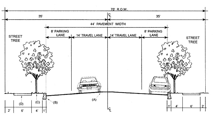
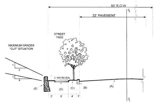
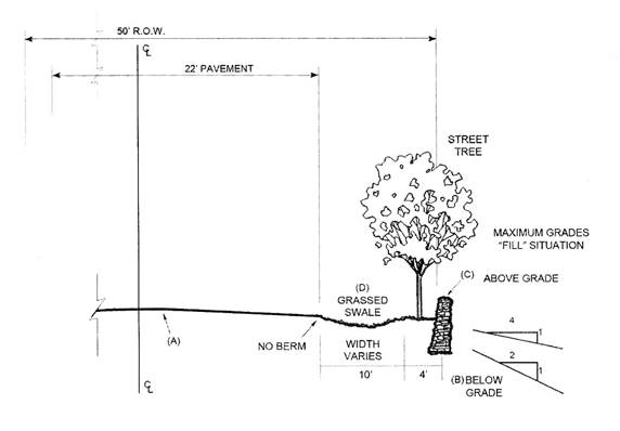
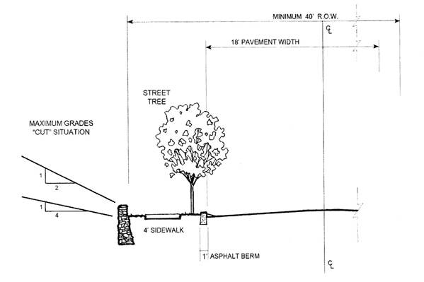
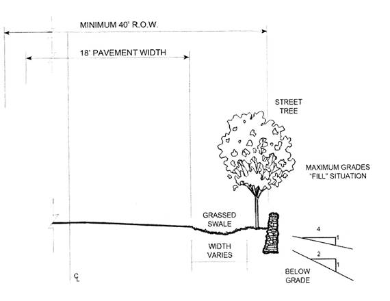
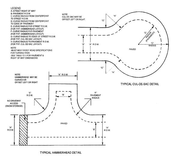
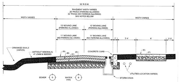
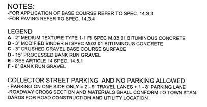
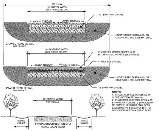
Street dimensions and design shall conform to Tables 13.1 and Table 13.2 and to the following Illustrations. The Planning Board shall have the discretion to vary the dimensions shown in Tables 13.1 and 13.2 at specific locations in consideration of public safety protection. The alternative rights-of-way construction shown in Figures 13-B and 13-C are subject to Planning Board approval.
TABLE 13.1 – MINIMUM STREET DIMENSIONS
| Street classification | ROW width | Pavement width excluding curbs and berms | Hammerhead ROW radius | Hammerhead pavement radius | Intersection fillet radius at ROW | Intersection fillet radius at pavement |
| Arterial | 70 ft | two 22-ft lanes | n/a | n/a | 25 ft | 35 ft |
| Collector | 50 ft | 22 ft | n/a | n/a | 25 ft | 35 ft |
| Local | 40 ft | 18 ft | 35 ft | 42 to 45 ft | 25 ft | 35 ft |
| Rural Local | 30 ft | 16 ft | 30 ft | 36 ft | 15 ft | 25 ft |
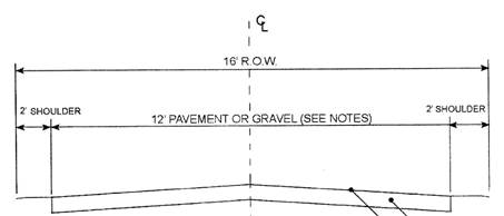
| Common Driveway | 16 ft | 12 ft | n/a | n/a | n/a | n/a |
TABLE 13.2 – GEOMETRIC DATA
| Street classification | Maximum grade at centerline | Maximum grade within 200 ft. of centerline intersection | Minimum grade at centerline | Minimum length for vertical curves* |
| Arterial | 8% | 2.5% | 1% | 35 x A |
| Collector | 8% | 2.5% | 1% | 30 x A |
| Local | 10% | 2.5% | 1% | 15 x A |
| Rural local | 10% | 2.5% | 1% | 10 x A |
| Street classification | Min.radius of centerline curve | Minimum design speed | Cul de sac & hammerhead max. grade | Cul de sac & hammerhead min. grade | Pavement crown (cross-slope) |
| Arterial | 500 ft.** | 40 mph | n/a | n/a | 2% |
| Collector | 350 ft.** | 35 mph | n/a | n/a | 2% |
| Local | 150 ft. | 25 mph | 2.5% | 2.5% | 2% |
| Rural local | 50 ft. | 15 mph | 2.5% | 2.5% | n/a |
*A = Algebraic difference in grades
** Smaller radii are permitted with increased roadway superelevation.
13.6 Street layout
13.6.1 General requirements
a) Street layout shall conform to the existing topography and follow the natural terrain wherever practicable.
b) The Planning Board may require the construction of pedestrian walkways and bicycle paths to provide access within a development or between a development and an adjoining property or nearby facility.
c) Local streets shall be located and designed to discourage use by through traffic wherever practicable.
d) Streets shall be continuous and in alignment with existing streets, as far as practicable, and connections shall be adequate to insure free circulation of traffic.
e) No street or path shall be constructed over any drainage system or over any part of an onsite wastewater treatment system other than a forced main or transport pipe.
13.6.2 Dead end streets
To promote efficient flow of traffic and to protect the public health and safety in emergencies, major subdivisions and major land development projects shall have two separate connections to a public street or streets outside the subdivision or land development project. Streets inside major subdivisions and major land development projects shall be looped, meaning that they are connected to another street at both ends. Cul de sacs and dead-end streets are prohibited in major subdivisions and major land development projects.
13.6.3 Private streets
Private streets are permitted only in minor subdivisions and residential compounds. The Planning Board shall determine whether streets in a land development project will be public or private. Private streets and associated drainage facilities shall be subject to the same approval process as public streets.
If a private street is not constructed at a minimum to the standards for a Local Street, the applicant shall record a document in the land evidence records at the time the plat is recorded certifying that neither the applicant nor his successors in title shall ask the Town of Richmond to accept for ownership any street in the development that is not constructed to Local Street standards.
13.6.4 Street alignment
a) Streets entering opposite sides of a local or collector street shall be laid out either directly opposite one another or at least two hundred (200) feet apart at their centerlines. Streets entering opposite sides of an arterial street shall be laid out either directly opposite one another or at least two hundred fifty (250) feet apart at their centerlines.
b) Streets entering on the same side of a local or arterial street shall be a minimum of two hundred fifty (250) feet apart at their centerlines.
c) Streets shall be laid out so as to intersect as nearly as possible at right angles. No street shall intersect any other street at an angle smaller than sixty (60) degrees.
d) All reverse curves on local streets shall be separated by a tangent at least one hundred (100) feet long. All reverse curves on arterial and collector streets shall be separated by a tangent at least two hundred (200) feet long.
13.6.5 Sight distance
a) The minimum sight distance at street intersections shall be the stopping sight distance recommended by AASHTO's A Policy on Geometric Design of Highways and Streets, latest edition, based on the 85th-percentile vehicle speed for existing roads and the design speed for proposed roads. If this sight distance cannot be achieved without offsite improvements, the Planning Board shall determine whether the improvements are practicable and reasonable based on the scope of the project.
b) Sight distance shall be provided within street lines. Easements shall not be used to provide sight distance unless no alternative is possible.
c) For any location where the Planning Board determines it is necessary to ensure continued adequate sight distances for vehicles, an easement to the Town shall be recorded that prohibits construction or erection of any structure, tree, wall, or any other visual obstruction.
13.6.6 Street names
All street names, including those of private streets, shall meet the following requirements:
a) An extension of a street shall have the same name as the street being extended.
b) The name of a new street shall not be the same as, or a homophone of, the name of any existing street in the Town and in the fire district.
c) The name shall be easy to spell and pronounce, and shall not exceed fifteen (15) letters, excluding the classifier (e.g., "Road," Drive").
d) Applicants are encouraged to propose street names that reflect Richmond's history, natural features, and noteworthy residents.
The Richmond Police Chief, the chief of the fire district in which the street is located, and the Director of Public Works shall approve street names before Final Approval.
13.6.7 Access to adjoining property
The Planning Board shall have the authority to require the applicant to provide access to adjoining property. In residential developments, the access may be obtained by continuing a street, a pedestrian path, or bicycle path to the property line, or by dedication of a parcel of land to the Town to provide a future connection. Reserve strips that prevent access to adjoining property shall not be permitted except where the Planning Board determines that they are necessary for the public health, safety and welfare or where they promote good planning practice or design.
13.7 Streetscape features
13.7.1 Street signs
At least one sign identifying the name of the street shall be erected on every new public and private street. Street name signs and traffic signs shall be approved by the Department of Public Works and shall be installed by the developer or by the Department of Public Works at the developer’s expense.
(Amended 4/25/17)
13.7.2 Street lighting
In all new residential developments, provision shall be made for street lighting connections only where the Director of Public Works determines that street lights are necessary for public safety. Street lights shall have full-cutoff luminaire heads with maximum 100 watt bulbs. The location of all street lights shall be shown on "as built" plans.
13.7.3 Pedestrian walkways
Pedestrian walkways adjacent to streets are not required, but the Planning Board shall have the authority to require pedestrian walkways where the proximity of the development to neighborhood businesses, schools, or other community facilities indicates that such pedestrian walkways will be needed, or if walkways are necessary to protect pedestrians from heavy traffic. The Planning Board shall have the authority to require the construction of pedestrian walkways as an off-site improvement.
As part of the Master Plan submission, an applicant shall submit an analysis of the pedestrian circulation anticipated in and near the proposed development. At Master Plan approval, the Planning Board shall specify the location and type of walkways and other pedestrian facilities, including walking paths or bicycle paths, to be included in the development.
13.7.4 Street trees
Street trees are required for all major residential subdivisions and land development projects that do not have adequate existing vegetation on site. The Planning Board shall have the authority to require street trees in non-residential major subdivisions and land development projects. Street trees shall satisfy the following standards:
a) Trees shall be deciduous shade trees appropriate for the landscape, terrain, soil and climatic conditions of the property and hardy to USDA Zone 6. Tree selection shall consider mature height and growth habit to ensure they do not interfere with road maintenance or overhead power lines. Species shall be chosen from the R.I. Native Plant Guide maintained by the University of Rhode Island Outreach Center and R.I. Natural History Survey Invasive species, as defined by the R.I. Invasive Species List maintained by the R.I. Invasive Species Council (R.I. Natural History Survey, R.I. Agricultural Experiment Station and the URI Cooperative Extension), or the Connecticut Invasive Plant List maintained by the Connecticut Invasive Plants Council, shall not be planted.
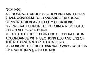
b) Trees shall be sited as shown in Figures 13-A, 13-B-1, 13-B-2, 13-C-1, and 13-C-2. Trees may be located on a building lot within ten (10) feet of the street right-of-way line if the developer can insure that the trees will not be disturbed by construction. Trees shall be located at least eight feet away from the paved surface of the street and shall be sited so that at maturity they do not interfere with overhead or underground utility lines. Trees shall be spaced thirty (30) to forty (40) feet on center, depending on the size at maturity. The location and type of trees shall be shown on Preliminary and Final plans.
c) At the time of planting, trees shall be at least two (2) inches in diameter at breast height and at least six (6) feet high from grade.
d) Trees shall be balled and burlapped with good root development and branching characteristics. Bare root, dormant trees may be planted only during the spring. Trees shall be of licensed nursery stock, or, if they are native-grown trees, shall be inspected and approved by the Tree Warden before planting.
e) Trees shall be planted in holes at least twice as wide as the root ball. Larger planting holes may be necessary in gravel or sand areas. Trees shall be planted at their previous depth in good quality topsoil or soil conditioned to that quality with organic matter such as peat moss and a balanced fertilizer. Trees shall be securely staked with at least three (3) sturdy stakes a minimum of two (2) inches by four (4) inches by eight (8) feet driven three (3) feet into the ground. Stakes shall be removed after six (6) months.
(f) Trees shall not be planted on the constructed banks of detention ponds.
(Amended 3/28/17)
13.7.5 Mailboxes
Mailboxes shall not be placed in a public street right-of-way. The use of common mailbox locations is required on both public and private streets.
13.7.6 School bus waiting zone parking bump-outs
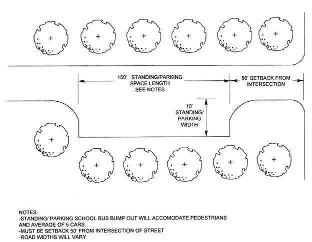
In residential developments, the Planning Board may require the construction of one or more street bump-outs near school bus waiting zones but at least 50 feet from street intersections. A school bus waiting zone parking bump-out is an area in the street right of way of sufficient width and length to accommodate at least five parked vehicles whose drivers are waiting for a school bus to arrive. The purpose is to prevent congestion of the street travel lanes.
13.8 Landscaping
13.8.1 When landscaping is required
Landscaping shall be included in all residential and non-residential major subdivisions and major land development projects at locations in the subdivision or development where the Planning Board determines it is necessary or appropriate to enhance the appearance of the development, provide a buffer between the development and adjacent property, replace vegetation removed during construction, or control soil erosion and sedimentation.
A dense evergreen buffer at least ten (10) feet deep shall be provided between a residential development and any abutting property that is zoned for commercial or industrial development. Other areas that may require landscaping include, but are not limited to:
a) Drainage facilities, such as retention or detention basins or drainage swales,
b) The entrances to a subdivision or development,
c) Open space,
d) Recreation facilities,
e) Buffer areas,
f) Areas that will be disturbed during construction,
g) Areas where a significant amount of natural vegetation will be removed by substantial grading, and
h) Areas that will require stabilization to prevent soil erosion and to control sedimentation.
Landscaping may consist of trees, shrubbery, ground cover, grass, or flowers, and may also include rocks, wetlands, stone walls, paving materials, lighting, planters, signage, and street furniture.
13.8.2 Landscape plan
When the Planning Board determines that landscaping is required, the applicant shall submit as part of the Preliminary Plan submission a landscape plan prepared by a registered landscape architect and conforming to the standards established by the R.I. Board of Registration for Landscape Architects. The plan shall include:
a) the location of existing and proposed trees, shrubs and ground covers; natural features such as stone walls and rock outcroppings, and man-made elements such as retaining walls, fences, signs, or planters,
b) proposed grading at two-foot contour intervals,
c) lighting,
d) specifications for loaming, fertilizing and seeding,
e) any necessary construction details,
f) a planting schedule that includes proposed species, size at time of planting and maintenance requirements;
g) proposed methods of protecting existing vegetation during construction.
Invasive plants identified in the R.I. Invasive Species List maintained by the Rhode Island Invasive Species Council (R.I. Natural History Survey, (R.I. Agricultural Experiment Station and the URI Cooperative Extension) or in the Connecticut Invasive Plant List maintained by the Connecticut Invasive Plants Council shall not be planted.
Lighting shall be designed and installed to be fully shielded (full cutoff) and shall have a maximum lamp wattage of 250 watts for commercial lighting, 100 watts incandescent, and 26 watts compact fluorescent for residential lighting. In residential areas, lights shall be shielded so that the lamp itself or the lamp image is not directly visible outside the property perimeter. Lighting fixtures shall have the International Dark-Sky Association (IDA) Fixture Seal of Approval.
13.9 Monuments
Monuments shall not be set until the completion of all construction that could disturb the monument. The surveyor who set the bounds shall certify in writing to the Director of Public Works that the bounds have been correctly set.
The Planning Board may require boundary markers or corner markers at locations in addition to those required by these regulations where they are necessary to delineate a boundary between public property and private property.
13.9.1 Boundary markers on streets and open space lots
Reinforced concrete boundary markers shall be placed by a registered land surveyor:
a) on the street line at the beginning and end of all horizontal curves on both sides of each public street, no more than five hundred (500) feet apart, and
b) along lot lines where they abut an Open Space lot.
Markers shall not be less than four (4) inches in diameter or square, and not less than forty-two (42) inches long. Bounds shall have a ?-inch drill hole or a marked metal disk at the center to allow for recovery. The markers shall be set two (2) inches above the finished grade.
13.9.2 Markers on lot corners
Rebar, steel pin markers, or equivalent corner markers shall be placed by a registered land surveyor at every point where the corner of a lot meets a right of way. Corner markers shall have a ½-inch outside diameter or larger and shall be placed flush with the surface of the ground.
13.10 Bicycle paths
The Planning Board may require an applicant to construct bicycle paths in major residential or non-residential subdivisions and developments to extend an existing bicycle path, to intersect with an existing or proposed State bicycle facility, to provide a connection to an adjacent subdivision where a vehicular connection would be impractical, or when nearby public or private facilities would be likely to generate significant bicycle traffic.
13.11 Easements
Easements shall be marked with concrete monuments or steel pin markers. The Planning Board may require easements to be marked with concrete monuments. Easements shall be recorded for the following purposes:
13.11.1 Water courses
An easement to the Town preventing interference with the natural flow of water shall be recorded for every water course, including drainage ways, channels, and streams. The easement area shall conform to the area occupied by the water course.
(Amended 4/25/17)
13.11.2 Drainage facilities
Easements to the Town at least twenty-five (25) feet wide shall be recorded to provide construction and maintenance access to underground or above-ground drainage facilities on private property. Where above-ground drainage is directed over private property that does not have a natural watercourse or wetland, or where publicly owned and maintained drainage systems outfall on private property, a drainage easement shall be recorded over the area where the flow or outfall occurs. When stormwater from public streets or other public improvements is to be directed to an above-ground drainage facility such as a detention pond, an easement to the drainage facility at least twenty-five (25) feet wide shall be recorded.
(Amended 4/25/17)
13.11.3 Grading
A grading easement to the Town shall be recorded to permit maintenance of grading on private property where such grading is necessary to establish or maintain adequate drainage, sight distances, or topographic features that are required as a condition of subdivision approval.
(Amended 4/25/17)
13.11.4 Sight distance
See 13.6.5.
13.11.5 Bicycle or pedestrian access
If a bicycle trail or pedestrian walkway is not granted to the Town in fee simple, an easement to the Town at least fifteen (15) feet wide shall be recorded.
13.11.6 Cisterns
When an underground cistern is installed on private property to provide water for firefighting, an easement shall be recorded providing the local fire district with access to the cistern for maintenance and for emergency purposes. See 13.13.
(Adopted 4/25/17)
13.12 Stormwater management systems
13.12.1 General requirements
a) The Town shall own and maintain all permanent stormwater management systems in residential and non-residential major subdivisions and major land development projects. Easements to the Town over private property shall be recorded to provide Town employees with access to the system.
b) Until the streets in a subdivision or land development project are accepted by the Town Council, the applicant shall maintain the stormwater management system.
c) Stormwater management systems may consist of natural and man made elements, including grass swales, surface or subsurface retention and detention basins, curbs, catch basins, culverts, and stormwater pipes.
d) Stormwater management systems shall be of adequate size and design to allow unimpeded flow of all natural waterways, to provide adequate drainage of all portions of the street system, and to prevent storm water runoff from reaching adjacent lots.
e) To the greatest extent practicable, stormwater management systems shall incorporate low impact design principles found in the Rhode Island Low Impact Development Site Planning and Design Guidance Manual published March 2011 by the Rhode Island Department of Environmental Management and the Coastal Resources Management Council. Stormwater management systems shall be designed to minimize the volume and rate of runoff and promote recharge as close as possible to the runoff source. Open drainage systems that provide a high level of infiltration, require little maintenance, and result in a minimum of clearing and grading, such as grassed swales or undisturbed natural areas suitable to absorb stormwater, are preferred over closed drainage systems. Stormwater management systems that include natural elements are preferred over systems that include man-made elements, because natural elements also mitigate pollution, reduce sedimentation, provide visual amenities and provide wildlife habitat. Several smaller stormwater management systems are preferred over one large stormwater management system.
f) Stormwater management systems may be located on open space lots. Surface elements shall be landscaped and integrated into the landscaping design of the development.
g) At full build-out of a development, peak stormwater flow and volume at the boundaries of the parcel shall not exceed peak flow and volume before development, measured at the same locations and based on the two-year, ten-year, twenty five-year, and one hundred year frequency storm designs.
h) All development shall comply with the Rhode Island Stormwater Design and Installation Standards Manual adopted December 2010 by the R.I. Department of Environmental Management and the Coastal Resources Management Council.
13.12.2 System design criteria
Stormwater management systems shall be designed by registered professional engineers. The system design, including stormwater drainage calculations and runoff rates and volumes, shall comply with the following:
a) Calculation of pre-development and post-development peak flows and volumes at the parcel boundaries, and calculation for design of detention and retention facilities, shall be made using the U.S. Department of Agriculture Natural Resources Conservation Service (NRCS) TR-20 or TR-55 methodology, unless the Planning Board approves the use of another method.
b) Calculation of peak flow rates for pipe sizing shall be developed using the Rational Method. All culverts or storm sewers shall be designed to accommodate, at minimum, a 10-year 24 hour Type III storm event as required by Section 3.2.4 of the Rhode Island Stormwater Design and Installation Standards Manual. Where the collection system conveys water to a detention or retention system designed to control a one hundred year frequency storm, the designer shall document how flows in excess of collection system capacity will be safely directed to the control devices. Culverts and storm sewers shall be designed with a minimum pipe size of twelve (12) inches. The minimum design velocity shall be three (3) feet per second and the maximum design velocity shall be ten (10) feet per second.
(Amended 3/28/17)
c) Where necessary for control of streams or other natural waterways, cross culverts shall be designed to accommodate a 100-year frequency storm.
d) The development of runoff coefficients for the rational method and runoff curve numbers for TR-55 and TR-20 methodology for post-development conditions in a development shall be based on the assumption that the parcel will be fully developed according to the plan to be approved by the Planning Board.
e) All stormwater system components shall be designed to account for hydraulic losses through the system, including inlet losses, outlet losses, and losses through hydraulic structures. Stormwater management system design shall account for anticipated tailwater conditions.
f) Existing wetlands shall not be used for stormwater treatment. However, where groundwater and surface water hydrology permit, and conditions favor creation of functional wildlife habitat, creation of wetland stormwater systems is encouraged.
g) Where detention basins are proposed to hold water for longer than forty-eight (48) hours, the applicant shall demonstrate how insects will be controlled.
h) Natural drainage patterns shall be maintained and existing watercourses shall be left open wherever practicable.
i) Where surface water volume or velocity will be high, the flow shall be controlled by rip rap, sediment basins, flow spreaders, or other devices or techniques recommended by the R. I. Soil Erosion and Sediment Control Handbook, as revised August 2014.
j) Drainage facilities for gravel or other pervious streets shall be designed to accommodate stormwater runoff for a paved street. Where a paved street meets an unpaved street, an impervious surface shall be constructed on the first fifty (50) feet of the unpaved street.
(Amended 4/25/17)
13.12.3 Design criteria for structures and appurtenances
a) Catch basins shall be located in pairs, one on each side of the street, at all low points or sag curves in the street, at intervals of not more than three hundred (300) feet on continuous grades of the street, and at or near the corners of the street on the up-gradient side of intersecting streets. Additional catch basins may be required based on the capacity of inlet grates to pass anticipated design flows.
b) Detention and retention facilities, including but not limited to detention basins or ponds, retention basins or ponds, swales, infiltration devices, and any device that can change the rate of flow through the use of storage in the device, shall be designed in accordance with latest edition of the R.I. Stormwater Design and Installation Standards Manual.
i. The top of any bank shall be at least five (5) feet wide to facilitate mowing and other maintenance.
ii. All detention devices and associated outlet structures shall be designed based on hydrologic/hydraulic analysis using the following methodology:
A. Runoff hydrographs shall be developed using the U.S. Department of Agriculture, Natural Resources Conservation Service Type III rainfall distribution, NRCS Runoff Curve Number Method of Abstractions or comparable methodology, and NRCS Unit Hydrograph or comparable methodology.
B. Runoff hydrographs shall be routed through the detention structure using the Storage-Indication method or comparable method, and shall include routing of the full runoff hydrograph through the structure and calculations deriving the stage/storage/discharge rating curve for the outlet structure, accounting for tailwater conditions Hydrologic parameters (Runoff Curve Number, time of concentration), shall be estimated using NRCS TR-55 or a comparable methodology. Examples of models that meet these criteria include: NRCS TR-20, US Army Corps of Engineers HEC-1 or HEC-RMS, US EPA Storm Water Management Model (SWMM).
iii. Retention facilities that are expected to contain water, or have an interior slope steeper than 3:1, shall be surrounded by a fence for safety. The Planning Board may permit the construction of a retention facility without fencing if the applicant can demonstrate that public safety and emergency access have been satisfactorily addressed by an alternative design. The location and details of the type of fencing shall be shown on the plans. Provision shall be made that enable wildlife to pass under any fencing.
iv. Detention and retention basins or ponds shall have a natural appearance. A rounded footprint is preferred over a rectilinear one.
c) The Planning Board may require subdrains where the finished grade of the street is less than four (4) feet above the water table or in other areas where the subgrade must be drained. The subdrain shall consist of a minimum of one longitudinal drain located so as to intercept water draining into the subgrade. In addition, laterals shall be required where water might accumulate in the subgrade. The system of subdrains shall be discharged into the stormwater management system through a catch basin or in another manner approved by the Planning Board. Subdrains shall be constructed according to the requirements of the most recent edition of Standard Specifications for Road and Bridge Construction (2004), published by the R.I. Department of Public Works, Division of Roads and Bridges.
d) Outfalls shall be designed to prevent soil erosion and located wherever necessary to prevent damage to natural resources or abutting properties. Outfalls shall extend to a point where they can drain along natural drainage paths. Where an outfall discharges to an abutting property or is set back from a natural drainage way or wetland, the applicant shall demonstrate the discharge will be safely conveyed without erosion, sedimentation or other adverse impact. Outlet protection shall consist of a properly designed rip rap apron, plunge pool or other energy dissipation structure, or level spreader. Stone for rip rap and plunge pools shall be sized according to the R.I. Soil Erosion and Sediment Control Handbook, as revised August 2014.
13.12.4 Contents of plans and supporting documentation
Stormwater management plans shall contain:
a) An estimate of the quantity of stormwater surface runoff presently flowing onto or from the property to appropriate on-site or off-site points of analysis, and an estimate of the stormwater surface run-off that will be generated by the proposed development, calculated on the basis of a two (2) year, ten (10) year, twenty-five (25) year, and one hundred (100) year, twenty-four (24) hour rainfall events. Adequate documentation must be provided including, but not limited to, a drainage narrative, peak flow rate and volume summaries, subwatershed maps, hydrologic/hydraulic computations, and water quality computations.
b) An analysis of the capability of existing and proposed depression storage, watercourses, storm sewers, culverts and other drainage facilities to handle the present and estimated run off, and how the increase will be managed.
c) Proposals for disposal of surface runoff downstream from the development without damage to land, to improvements, or to the receiving water body.
d) How the following specific requirements will be met:
i. Each lot shall be adequately drained.
ii. Natural drainage patterns shall be maintained whenever practicable.
iii. Existing watercourses shall be left open unless the Planning Board specifically determines otherwise.
iv. New open watercourses shall have appropriate surface cover (e.g. seed, sod, rip rap, pavement, or channel reinforcement) depending on grades, soil types, and estimated flow velocities.
v. A continuous drainage system shall be installed and connected to a natural or manmade water course or to an existing piped stormwater management system that will deliver the water to a permanent natural water body or wetland or a retention area that can accommodate a 100-year frequency rainfall.
13.13 Cisterns
Underground cisterns provide water for firefighting in areas where public water is not available. The Planning Board has the authority to require the installation of one or more cisterns in a subdivision or land development project if the Board finds that the cistern is necessary to protect the public health, safety and welfare.
13.13.1 a) When the Administrative Officer forwards a copy of the Master Plan application for a major subdivision or land development project to the appropriate fire district, the Administrative Officer shall ask the fire district for a written recommendation on whether a cistern should be required, addressing the criteria in 13.13.2 and stating the reasons for the recommendation.
b) After the Pre-Application conference for a minor subdivision or land development project, the developer shall consult with the local fire district concerning whether a cistern should be installed. The developer shall ask the fire district to provide a written recommendation to the Planning Board that addresses the criteria in 13.13.2 and states the reasons for the recommendation. The written recommendation shall be included in the Preliminary Plan application.
13.13.2 The Planning Board shall consider the following factors when deciding whether to require one or more cisterns in a development:
a) The number of proposed buildings in the development and whether the buildings are intended for residential use.
b) The number and storage capacity of the fire district’s pumper trucks.
c) The distance to the nearest water body that could provide water for firefighting.
d) The recommendation of the local fire district.
13.13.3 If a cistern is required, it shall have a capacity of at least 10,000 gallons and shall be in a location accessible to fire trucks. The developer shall convey an access easement to the fire district. The fire district shall be responsible for filling and maintaining the cistern.
(Adopted 4/25/17)
13.14 Utilities
All new utility lines in or adjacent to major subdivisions and major land development projects shall be installed underground. Equipment associated with the underground utilities that ordinarily is located above ground may be installed above ground.
13.14.1 Water lines
When public water is available, water lines shall be installed and water stops shall be provided for each lot in compliance with applicable ordinances and with regulations promulgated by Richmond Water Supply Board. Water lines shall be installed on the south or west side of the street. The applicant shall submit written confirmation from the Richmond Water Supply Board that public water is available to the development and that the water supply is adequate to serve the development.
13.14.2 Gas lines
Natural gas lines may be installed in any development. Gas lines shall be installed on the north or east side of the street.
13.14.3 Electric, telephone, and cable lines
Electric, telephone, cable, and similar lines shall be installed underground except in residential compounds, in minor subdivisions where no street creation is required, or where underground installation is not practicable. All underground utility installation shall be completed before streets are paved.
13.14.4 Fire hydrants or storage tanks
Fire hydrants shall be installed in all developments where public water is installed. Hydrant type and location shall satisfy the minimum requirements of the National Fire Protection Association (NFPA) and shall be approved by the chief of the fire district. Where public water is not available, in-ground dry hydrants, storage tanks, or cisterns shall be installed in sizes and locations determined by the chief of the fire district according to NFPA standards. The applicant shall grant an easement to the fire district for maintenance access to any such in-ground storage facility.
13.15 Soil erosion and sediment control
To prevent soil erosion and sedimentation during construction, all major subdivisions and major land development projects are required to submit a soil erosion and sediment control plan prepared by a registered professional engineer, a registered landscape architect, a Certified Erosion, Sediment and Storm Water Inspector or a Certified Professional in Storm Water Quality certified by Certified Professional in Erosion and Sediment Control, Inc. The Planning Board may require minor subdivisions and minor land development projects to submit a soil erosion and sediment control plan if the Board determines that the proposed land disturbance warrants such a plan.
13.15.1 Contents of plan
The erosion and sediment control plan shall include sufficient information about the property and the proposed development to provide a basis for discussion and review and to assure compliance with all applicable requirements of these Regulations. The plan shall be consistent with the data collection, data analysis, and plan preparation guidelines of the R. I. Soil Erosion and Sediment Control Handbook, published jointly by the R.I. Department of Environmental Management and the U. S. Department of Agriculture, Natural Resources Conservation Service (NRCS).
The plan shall contain, at minimum:
a) A description of the proposed land disturbing activity and the soil erosion and sediment control measures and stormwater management measures to be installed to control erosion that could result from the proposed activity. Supporting documentation, such as a drainage area, existing site conditions, and soil maps, shall be provided.
b) Construction drawings illustrating in detail all land disturbing activity, including existing and proposed contours, cuts and fills, drainage features, and vegetation; limits of clearing and grading; location and detail drawing of soil erosion and sediment control and stormwater management measures; location of stock piles and borrow areas; sequence and staging of land disturbing activities; and any other information needed for construction.
c) Illustrations or narratives describing how construction waste will be managed. Detail drawings of measures, stock piles and borrow areas, waste collection and burial areas, and concrete truck wash out sites shall be included. Storage, disposal, or use as fill of material containing asphalt, concrete, construction debris or stumps is prohibited.
d) It shall include a description of the sequence and staging of land disturbing activities, and a schedule of the sequence of construction, inspection, and maintenance of erosion and sediment control measures. The plan shall show areas to be sodded, seeded, or otherwise restored, and areas where soil infiltration must be restored by use of soil amendments because of soil compaction expected to occur during construction.
13.15.2 Measures required during construction
a) The applicant shall be responsible for maintenance of all erosion and sediment control features during construction. If those features are not adequately maintained, the Administrative Officer is authorized to use improvement guarantees posted by the applicant to pay for maintenance.
b) Temporary vegetation or mulch shall be used to protect bare areas and stockpiles from erosion during construction. The smallest areas feasible shall be exposed at any one time.
c) Disturbed areas shall be protected during the nongrowing months of November through March.
d) Permanent vegetation shall be placed immediately after fine grading.
e) The area within the drip line of trees to be retained shall be fenced or roped off to protect the trees from damage by construction equipment.
f) All areas damaged during construction shall be resodded, reseeded, or otherwise restored.
13.16 Off-site improvements
13.16.1 When the proposed development will have a significant negative impact on public health and safety in the surrounding area, the Planning Board shall have the authority to require the developer to construct or install infrastructure improvements at a site not located on the parcel being developed, or contribute funds toward infrastructure improvements, provided that:
a) The significant negative impact the development will have on existing conditions must be clearly documented by a qualified professional.
b) As part of the Preliminary Plan approval, the Planning Board shall make findings of fact describing the direct and significant effects the development is expected to have on existing conditions and how the required infrastructure improvements will directly mitigate those effects.
c) The required improvements must reflect the character of the surrounding area as it is described in the Comprehensive Community Plan.
d) If the developer will construct the infrastructure improvements during or after construction of the development, the Planning Board shall have the authority to require the developer to post a bond at the time the Final Plan is recorded to insure that the infrastructure improvements will be constructed.
e) If the developer contributes funds toward the cost of infrastructure improvements, the funds shall be placed in a restricted account and shall be used only to mitigate the identified impacts. If the funds are not spent within five years after construction of the development is complete, the town must return the funds to the developer.
(Amended 4/25/17)
13.17 Flood hazard areas
If any part of a proposed development is located in an area designated by the Federal Emergency Management Agency as a floodplain or special flood hazard area, the proposed materials, design, and methods of construction shall provide for adequate protection from flood damage, all public utilities and facilities such as sewers, gas, electrical and water systems shall be elevated and constructed to minimize or eliminate damage from flooding, and adequate drainage shall be provided to reduce exposure to flood hazards. As a condition of Final Approval, a registered professional engineer shall certify that the development is designed to minimize danger from flooding.
(Adopted 9/3/09; amended 1/13/09 without illustrations; amended 8/11/09 with illustrations; amended 10/27/15; amended 4/25/17)
ILLUSTRATIONS
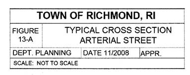
13-A Typical cross-section for arterial street.
13-B-1 Typical cross-section for a rural collector street, above-grade and pedestrian walkway alternatives.
13-B-2 Typical cross-section for a rural collector street, below-grade and grassed swale alternatives.
13-C-1 Typical cross-section for a local street, above-grade and pedestrian walkway. alternatives.
13-C-2 Typical cross-section for a local street, below-grade and grassed swale alternatives.
13-D Typical cross-section for a shared (common) driveway.
13-E Shared (common) driveway for a minor subdivision involving no street creation or extension.
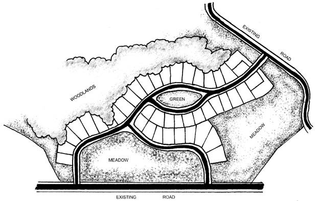
13-F Typical cul de sac and hammerhead details.
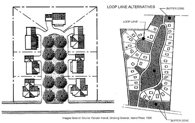
13-G Typical buffer along street.
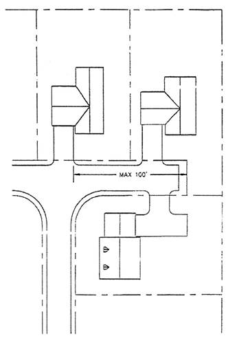
13-H Cul de sac loop lane.
13-I Short dead-end street (minor subdivision).
13-J School bus waiting zone parking bump-out.
13-K Typical cross-section for collector street.
13-L Typical cross-section for rural local street.
