APPENDIX B LAND DEVELOPMENT AND SUBDIVISION REGULATIONS[1]
ARTICLE I. GENERAL PROVISIONS
Sec. 23-1. Title and applicability.
This chapter shall be known as the "Tiverton Land Development and Subdivision Regulations," or chapter 23 [appendix B] of the Code of the Town of Tiverton. It shall be applicable in all cases of the subdivision of land, including resubdivision; in all cases of land development projects as provided for in section 45-24-47 of the Zoning Enabling Act of 1991 (G.L. 1956, § 45-24-47); and in all cases of development plan review, as provided for in section 45-24-49 of the Zoning Enabling Act of 1991 (G.L. 1956, § 45-24-49).
Sec. 23-2. Enabling authority.
In accordance with the provisions of the Land Development and Subdivision Review Enabling Act of 1992, G.L. 1956, ch. 45-23, the planning board of the Town of Tiverton hereby adopts the following regulations governing land development and the subdivision of land. All prior regulations governing such subdivision of land and all prior amendments thereto are hereby repealed.
Sec. 23-3. Consistency requirements.
a. The land development and subdivision regulations set forth in this chapter have been made in accordance with the Tiverton comprehensive plan, adopted or amended pursuant to G.L. 1956, § 45-22.2-1 et seq., with the Tiverton zoning ordinance, appendix I [appendix A] of the Code of the Town of Tiverton, adopted or amended pursuant to G.L. 1956, § 45-24-1 et seq., and with all other duly adopted local development regulations.
b. In the instance of uncertainty in the construction or application of any section of these regulations, the regulations shall be construed in a manner that will further the implementation of, and not be contrary to, the goals and policies and applicable elements of the Tiverton comprehensive plan. Furthermore, these regulations shall be construed in a manner which is consistent with the legislative findings, intents and purposes of sections 45-23-25 through 45-23-74 of the Land Development and Subdivision Review Enabling Act of 1992 (G.L. 1956, §§ 45-23-25—45-23-74).
Sec. 23-4. Statement of purposes.
These regulations address the following purposes, as contained in section 45-23-30 of the Land Development and Subdivision Review Enabling Act of 1992 (G.L. 1956, § 45-23-30):
a. Provide for the orderly, thorough and expeditious review and approval of land developments and subdivisions;
b. Promote high quality and appropriate design and construction of land developments and subdivisions;
c. Promote the protection of the existing natural and built environment and the mitigation of all significant negative impacts of any proposed development on the existing environment;
d. Promote design of land developments and subdivisions which are well-integrated with the surrounding neighborhoods with regard to natural and built features, and which concentrate development in areas which can best support intensive use by reason of natural characteristics and existing infrastructure;
e. Provide guidelines for local design and improvement standards that reflect the intent of the Tiverton comprehensive plan with regard to the physical character of the various neighborhoods and districts of the Town of Tiverton;
f. Promote thorough technical review of all proposed land developments and subdivisions by appropriate local officials;
g. Provide guidelines for dedications of public land, impact mitigation and payment-in-lieu thereof, that are based on clear documentation of needs and are fairly applied and administered; and
h. Provide procedures for local recordkeeping on all matters of land development and subdivision review, approval and construction.
ARTICLE II. DEFINITIONS
Sec. 23-5. Terms defined.
For the purposes of this chapter, the following words and phrases shall have the meanings respectively ascribed to them in this article. Definitions contained in G.L. § 45-23-32 of the Land Development and Subdivision Review Enabling Act of 1992 (G.L. 1956, § 45-23-32), as amended, which shall be controlling, are denoted by italics. In addition, where words or phrases used in these regulations are defined in G.L. § 45-22.2-4 of the Rhode Island Comprehensive Planning and Land Use Regulation Act (G.L. 1956, § 45-22.2-4), as amended, or G.L. § 45-24-31 of the Zoning Enabling Act of 1991 (G.L. 1956, § 45-24-31), as amended, they shall have the meanings stated therein.
(1) Administrative officer. The municipal official(s) designated by the local regulations to administer the land development and subdivision regulations and to review and approve qualified applications and/or coordinate with local boards and commissions, municipal staff and state agencies as set forth herein. The administrative officer may be a member of, or the chair, of the planning board, an employee of the municipal planning or zoning departments, or an appointed official of the municipality (see G.L. § 45-23-55).
(2) Administrative subdivision. Subdivision of existing lots which yields no additional lots for development and involves no creation or extension of streets as allowed under appendix B, Land Development and Subdivision Regulations and the General Laws of the State of Rhode Island. This subdivision only involves division, mergers, mergers and division, or adjustments of boundaries of existing lots.
(3) Board of appeals. The local review authority for appeals of actions of the administrative officer, which shall be the local zoning board of review convened as the board of appeal (see G.L. § 45-23-57).
(4) Bond. See Improvement guarantee.
(5) Buildable lot. A lot where construction for the use(s) permitted on the site under the Tiverton zoning ordinance is considered practicable by the planning board, considering the physical constraints to development of the site as well as the requirements of the pertinent federal, state and local regulations.
(6) Certificate of completeness. A notice issued by the administrative officer informing an applicant that the application is complete and meets the requirements of the municipality's regulations, and that the applicant may proceed with the review process.
(7) Concept plan. A drawing with accompanying information showing the basic elements of a proposed land development plan or subdivision as used for preapplication meetings and early discussions, and classification of the project within the approval process.
(8) Consistency with the comprehensive plan. A requirement of all local land use regulations, which means that all such regulations and subsequent actions shall be in accordance with the public policies arrived at through detailed study and analysis and adopted by the town as the Tiverton comprehensive plan.
(9) Dedication, fee-in-lieu-of. Payments of cash that are authorized in these regulations when requirements for mandatory dedication of land are not met because of physical conditions of the site or other reasons.
(9.5) Development plan review. Design or site plan review of a development of a permitted use. A municipality may utilize development plan review under limited circumstances to encourage development to comply with design and/or performance standards of the community under specific and objective guidelines, for developments including, but not limited to:
(a) A change in use at the property where no extensive construction of improvements is sought;
(b) An adaptive reuse project located in a commercial zone where no extensive exterior construction of improvements is sought;
(c) An adaptive reuse project located in a residential zone which results in less than nine residential units;
(d) Development in a designated urban or growth center;
(e) Institutional development design review for educational or hospital facilities; or
(f) Development in a historic district.
See appendix B, Land Development and Subdivision Regulations, article XVI, as well as G.L. §§ 45-23-32 and 45-23-50.
(10) Development regulation. Zoning, subdivision, land development plan, development plan review, historic district, official map, floodplain regulation, soil erosion control or any other governmental regulation of the use and development of land.
(11) Division of land. A subdivision.
(12) Easement. A grant for an indefinite period of the right of use of land for drainage or utility purposes.
(13) Environmental constraints. Natural features, resources or land characteristics that are sensitive to change and may require conservation measures or the application of special development techniques to prevent degradation of the site, or may require limited development, or in certain instances, may preclude development. See also Physical constraints to development.
(14) Final plan. The final stage of land development and subdivision review.
(15) Final plat. The final drawing(s) of all or a portion of a subdivision to be recorded after approval by the planning board and any accompanying material as described in these regulations and/or required by the planning board.
(15.5) Flexible zoning. As defined in article II of the town zoning ordinance.
(16) Floor area, gross. See R.I. State Building Code.
(17) Governing body. The body of the local government, generally the town council, having the power to adopt ordinances, accept public dedications, release public improvement guarantees and collect fees.
(18) Improvement. Any natural or built item which becomes part of, is placed upon or is affixed to real estate.
(19) Improvement guarantee. A security instrument accepted by the town to ensure that all improvements, facilities or work required by these land development and subdivision regulations, or required by the town as a condition of approval, will be completed in compliance with the approved plans and specifications of a development.
(19.5) Land-development project. A project in which one or more lots, tracts, or parcels of land or a portion thereof are developed or redeveloped as a coordinated site for one or more uses, units, or structures, including, but not limited to, planned development or cluster development for residential commercial, institutional, recreational, open space, or mixed uses.
(20) Local regulations. The land development and subdivision review regulations for the Town of Tiverton (these regulations), adopted under the provisions of the Land Development and Subdivision Review Enabling Act of 1992, and all related ordinances and rules.
(21) Maintenance guarantee. Any security instrument that may be required and accepted by the town to ensure that necessary improvements will function as required for a specific period of time. See "Improvement guarantee."
(22) Major land development plan. A land development project which exceeds the thresholds for a minor land development project as set forth in this section and appendix B, Land Development and Subdivision Regulations, article VI, Minor Land Development or Subdivision, and which is allowed under appendix B, Land Development and Subdivision Regulations, article VII, Major Land Development or Subdivision, and the General Laws of the State of Rhode Island.
(23) Major subdivision. A subdivision creating ten or more buildable lots as allowed under appendix B, Land Development and Subdivision Regulations, article VII, Major Land Development or Subdivision, and the General Laws of the State of Rhode Island.
(24) Master plan. An overall plan for a proposed project site outlining general, rather than detailed, development intentions. It describes the basic parameters of a major development proposal, rather than giving full engineering details. Required in major land development or major subdivision review only. It is the first formal review step of the major land development or major subdivision process and the step in the process in which the public hearing is held (see G.L. § 45-23-39).
(25) Minor land development plan. A land development project involving any one of the following as allowed under appendix B, Land Development and Subdivision Regulations, article VI, Minor Land Development or Subdivision, and the General Laws of the State of Rhode Island:
• Seven thousand five hundred gross square feet of floor area of new commercial, manufacturing or industrial development; or less.
• An expansion of up to 50 percent of existing floor area or up to 10,000 square feet for commercial, manufacturing, or industrial structures.
• Mixed-use development consisting of up to six dwelling units and 2,500 gross square feet of commercial space or less.
• Multi-family residential or residential condominium development of nine units or less.
• Change in use at the property where no extensive construction of improvements are sought.
• An adaptive reuse project of up to 25,000 square feet of gross floor area located in a commercial zone where no extensive exterior construction of improvements is sought.
• An adaptive reuse project located in a residential zone which results in less than nine residential units.
(26) Minor subdivision. A subdivision of land creating nine or fewer buildable lots as allowed under appendix B, Land Development and Subdivision Regulations, article VI, Minor Land Development or Subdivision, and the General Laws of the State of Rhode Island.
(27) Modification of requirements. See section 23-47 of these regulations.
(28) Parcel. A lot, or contiguous group of lots in single ownership or under single control, and usually considered a unit for purposes of development. A parcel is also referred to as a tract.
(29) Parking area or lot. All that portion of a development that is used by vehicles, the total area used for vehicular access, circulation, parking, loading and unloading.
(30) Permitting authority. The local agency of government, meaning any board, commission or administrative officer specifically empowered by state enabling law and local regulation or ordinance to hear and decide specific matters pertaining to local land use.
(31) Phased development. Development, usually for large-scale projects, where construction of public and/or private improvements proceeds by section(s) subsequent to approval of a master plan for the entire site.
(32) Physical constraints to development. Characteristics of a site or area, either natural or manmade, which present significant difficulties to construction of the uses permitted on that site, or would require extraordinary construction methods. See also Environmental constraints.
(33) Planning board. The official planning agency of the Town of Tiverton, designated as the Tiverton Planning Board.
(34) Plat. A drawing or drawings of a land development or subdivision plan showing the location, boundaries and lot lines of individual properties, as well as other necessary information as specified in these regulations.
(35) Preapplication conference. An initial meeting between developers and town representatives that affords developers the opportunity to present their proposals informally and to receive comments and directions from the town officials and others.
(36) Preliminary plan. A required stage of land development and subdivision which generally requires engineered drawings.
(37) Public hearing. A meeting of the planning board preceded by appropriate public notice, at which either the adoption or amendment of these regulations is under consideration, or testimony on behalf of proposed development or subdivision projects is heard and public comment is taken. The decision of the planning board at a public hearing shall be appealable.
(38) Public improvement. Any street or other roadway, sidewalk, pedestrian way, tree, lawn, off-street parking area, drainage feature or other facility for which the local government or other governmental entity either is presently responsible, or will ultimately assume the responsibility for maintenance and operation upon acceptance by the town.
(39) Reserved.
(40) Reserved.
(40b) Scenic viewshed. The attractive, distinctive and pleasing landscape or water view within the prospect, vista or field of vision of motorists, cyclists and pedestrians traveling along roads, streets, lanes or other public rights-of-way.
(40c) Stone wall. A vertical structure of aligned natural stone, originally constructed in the 17th, 18th, 19th or 20th centuries to designate a property boundary between farmsteads or to segregate agricultural activities within a single farmstead or to designate property lines.
(41) Stormwater management plan. A plan detailing a system of vegetative, structural and/or other measures to control the volume and rate of stormwater runoff, and minimize the flooding and water quality degradation which can result from land disturbing activity.
(42) Stormwater detention. A provision for storage of stormwater runoff and the controlled release of such runoff during and after a flood or storm.
(43) Stormwater retention. A provision for storage of stormwater runoff.
(44) Street. A public or private thoroughfare used, or intended to be used, for passage or travel by motor vehicles. Streets are further classified by the functions they perform. See Street classification.
(45) Street, access to. An adequate and permanent way of entering a lot. All lots of record shall have access to a public street for all vehicles normally associated with the uses permitted for that lot.
(46) Street, alley. A public or private thoroughfare primarily designed to serve as secondary access to the side or rear of those properties whose principal frontage is on some other street.
(47) Street, cul-de-sac. A local street with only one outlet and having an appropriate vehicular turnaround, either temporary or permanent, at the closed end.
(48) Street, limited access highway. A freeway or expressway providing for through traffic. Owners or occupants of abutting property on lands and other persons have no legal right to access, except at such points and in such manner as may be determined by the public authority having jurisdiction over the highway.
(49) Street, paper. A public street that has been platted but not improved.
(50) Street, private. A thoroughfare established as a separate tract for the benefit of multiple adjacent properties and meeting specific municipal improvement standards. This definition shall not apply to driveways.
(51) Street, public. All public property reserved or dedicated for street traffic.
(52) Street, stub. A portion of a street reserved to provide access to future development that may provide for utility connections.
(53) Street classification. A method of roadway organization that identifies a street hierarchy according to function within a road system, that is, types of vehicles served and anticipated volumes, for the purposes of promoting safety, efficient land use and the design character of neighborhoods and districts. Local classifications shall use the following as major categories:
(a) Arterial. A major street that serves as an avenue for the circulation of traffic into, out of or around a municipality and carries high volumes of traffic.
(b) Collector. A street whose principal function is to carry traffic between local streets and arterial streets but that may also provide direct access to abutting properties.
(c) Local. A street whose primary function is to provide access to abutting properties.
(54) Structural best management practices. Structural devices that temporarily detain and treat stormwater in order to control peak discharge rates and reduce pollutant loadings. The mechanisms for pollutant removal are based on gravity settling, infiltration and biological uptake. Typical best management practices (BMPs) include wet ponds, infiltration trenches, created wetlands and grassed swales.
(55) Subdivider. Any person who: (1) having an interest in land, causes it, directly or indirectly, to be divided into a subdivision or who; (2) directly or indirectly sells, leases or develops, or offers to sell, lease or develop, or advertises to sell, lease or develop, any interest, lot, parcel, site, unit or plat in a subdivision, or who; (3) engages directly or through an agent in the business of selling, leasing, developing or offering for sale, lease or development a subdivision or any interest, lot, parcel, site, unit or plat in a subdivision.
(56) Subdivision. The division of a lot, tract or parcel of land into two or more lots, tracts, or parcels or any adjustment to existing lot lines is considered a subdivision.
(57) Technical review committee. A committee appointed by the planning board for the purpose of reviewing, commenting and making recommendations to the planning board with respect to approval of land development and subdivision applications.
(58) Temporary improvement. Improvements built and maintained by a developer during construction of a development project and prior to release of the improvement guarantee, but not intended to be permanent.
(59) Town engineer. A registered professional engineer who provides engineering services to the Town of Tiverton, either on a contractual basis or as a town employee.
(60) Vested rights. The right to initiate or continue the development of an approved project for a specified period of time, under the regulations that were in effect at the time of approval, even if, after the approval, the regulations change prior to the completion of the project.
(61) Waiver of requirements. See section 23-47 of these regulations.
(62) Yield plan. A plan of development demonstrating the maximum density (number of lots or units) on a given parcel or parcels of land based on the zoning designation, meeting all applicable environmental and dimensional requirements. A yield plan shall take into account all environmental, natural, and man-made physical constraints to development, including, but not limited to, wetlands, topography, groundwater characteristics, view sheds and existing improvements. The submission requirements for a yield plan are provided in Article XVII of these regulations.
(Ord. of 6-26-03; Ord. of 9-13-11; Ord. No. 11-30-23(16); Reg. No. 2024-1, 8-7-24)
ARTICLE III. ADMINISTRATION AND ENFORCEMENT
Sec. 23-6. Administrative officer.
a. Appointment and removal. Local administration of these regulations shall be under the direction of the administrative officer, who shall report to the planning board. The administrative officer shall be appointed in accordance with the town Charter, with a recommendation by the planning board. The initial appointment of an administrative officer may be for a one-year probationary period, or less, with subsequent appointments for up to two years.
b. Qualifications. The administrative officer may be a member of the planning board, including the chair of the planning board, but may not be any member of the zoning board of review. The administrative officer must be thoroughly familiar with land use planning and with local, state and federal land use regulations, including zoning regulations, the subdivision review process and R.I. Department of Environmental Management requirements and procedures. Experience may include, but is not limited to, current and satisfactory service as a member of a municipal planning board; employment as a municipal planner or as a building official or inspector; employment with a consulting firm dealing with land use planning; or one who is a registered professional architect, engineer, surveyor or soil scientist.
c. Duties. The administrative officer shall be responsible for the following:
(1) Overseeing and coordinating the review, approval, recording and enforcement provisions of these regulations, and serving as the chair of the technical review committee, where established.
(2) Coordinating reviews of proposed land development projects and subdivisions with adjacent municipalities as is necessary to be consistent with applicable federal, state and local laws, and as directed by the planning board.
(3) Enforcement of these regulations, including coordinating the enforcement efforts of the zoning officer, planning board staff, the town engineer should one be appointed, the department of public works and other local officials responsible for the enforcement or carrying out of discrete elements of these regulations.
(4) Representation of the planning board before other bodies and agencies of the town and state, with the consent of the board, and any other functions or duties as agreed to and requested by the board.
Sec. 23-7. Technical review committee.
a. There is hereby established a technical review committee ("TRC") the members of which are appointed by the planning board in accord with the policies and procedures the board adopts. The TRC is responsible for conducting advisory technical reviews in accord with subsections d. and e., herein.
b. Membership.
1. The TRC may include:
i. Administrative officer;
ii. Zoning official or his/her designee;
iii. Fire marshal or his/her designee;
iv. Department of public works or his/her designee;
v. Police chief or his/her designee;
vi. A member of the conservation commission;
vii. The planning board consulting engineer;
viii. At least one and no more than three members of the planning board.
2. The administrative officer shall serve as chair of the TRC.
3. The administrative officer may invite others to sit as full members for specific projects where there is a specialized knowledge, skill, or expertise required for review.
c. Upon the establishment of a technical review committee, the planning board shall adopt written procedures establishing the committee's policies, procedures and responsibilities.
d. Reports of the technical review committee to the planning board shall be in writing, and shall be kept as part of the permanent documentation on any development or subdivision application. In no case shall the recommendations of the technical review committee be binding on the planning board in its activities or decisions. The recommendation of the TRC shall be made available to the applicant prior to a decision by the permitting authority.
e. Review of applications in an advisory capacity.
1. The TRC shall review the following types of applications in an advisory capacity and shall provide an affirmative or negative recommendation in the form of a vote to the administrative officer:
i. Minor land development projects and subdivisions at all stages;
ii. Major land development projects and subdivisions, provided that the TRC reviews the application prior to the planning board's first meeting on the application;
iii. Administrative subdivisions at the request of the administrative officer;
iv. Comprehensive permit applications;
v. Minor modifications or changes to land development and subdivision applications, at any stage of the application process and after a final plan has been recorded, at the request of the administrative officer;
vi. Major modifications or changes to land development and subdivision applications, at any stage of the application process and after a final plan has been recorded, at the request of the administrative officer or planning board;
vii. Administrative development plan review applications;
viii. Formal development plan review applications;
ix. Other matters referred to the TRC by the town council, planning board, zoning board, administrative officer or zoning officer.
(Ord. of 11-30-23(13))
Sec. 23-8. Fees.
Application fees for development and subdivision projects shall be set by the Tiverton Town Council, and shall be payable to the Town of Tiverton upon submission of said applications to offset the costs of review and hearing of applications, issuance of permits and recording of decisions. The current fees are contained in the submission requirement checklists attached to these regulations. The planning board shall review the fees on an annual basis, and make recommendations to the town council regarding any appropriate changes.
Sec. 23-9. Violations and penalties.
a. Any violation of these regulations, or of any terms or conditions of any action imposed by the planning board or of any other agency or officer charged in these regulations with enforcement of any of the provisions, shall be subject to a penalty.
b. Violation of these regulations shall include any action related to the transfer, sale, or leasing of land in unapproved subdivisions or land developments. Such action shall include signage and media advertising. Any owner, or agent of the owner, who transfers, sells, leases, or advertises or negotiates to sell or lease any land by reference to or exhibition of, or by other use of, a plat of the subdivision or land development before the plat has been approved by the planning board and recorded in the town land evidence records, shall be in violation of these regulations and subject to the penalties described herein.
c. Any sale of land subdivided or developed in violation of the provisions of these regulations shall be voidable at the option of the purchaser thereof, and shall subject the seller thereof to forfeiture of any and all consideration received or pledged therefor together with any damages sustained by such purchaser, who may maintain an action on the case to recover any amounts due him under the provisions of this section.
d. The penalty for violation shall reasonably relate to the seriousness of the offense, and shall not exceed $500.00 for each violation, and each day of existence of any violation shall be deemed to be a separate offense. Any such fine shall inure to the Town of Tiverton.
e. The town may also cause suit to be brought in the supreme or superior court, or any municipal court, including a municipal housing court having jurisdiction in the name of the town, to restrain the violation of, or to compel compliance with, the provisions of these regulations. The town may consolidate an action for injunctive relief and/or fines under these regulations in the superior court.
(Ord. of 6-26-03)
Sec. 23-10. Publication and availability of regulations.
a. Printed copies of these regulations, and any amendments thereto, shall be available to the general public at a reasonable charge. Any appendices shall also be available.
b. Upon publication of these regulations and any amendments thereto, the town shall send a copy to the Rhode Island Department of Administration, Division of Planning, and to the state law library.
ARTICLE IV. APPLICATION PROCEDURES
Sec. 23-11. Classification of applications.
Any applicant intending to undertake a land development or subdivision project in the Town of Tiverton shall file an appropriate application with the planning board.
The administrative officer shall advise the applicant as to which category of approval is required for a project. An applicant shall not be required to obtain both land development review and development plan review for the same project. The following categories of applications may be filed:
1. Subdivisions. Administrative subdivisions, minor subdivisions, or major subdivisions;
2. Land development projects. Minor land development or major land development; and
3. Development plan review.
All subdivisions and/or land development projects that result in the creation of four or more units or lots are subject to the provisions of Article XVII, Conservation Development, of these regulations and shall further comply with the requirements set forth therein.
(Ord. of 11-30-23(10); Reg. No. 2024-1, 8-7-24)
Sec. 23-12. Certification of completeness.
a. An application shall be complete for purposes of commencing the applicable time period for action when so certified by the administrative officer. Every certification of completeness required by this chapter shall be in writing. In the event the certification of the application is not made within the time specified in this chapter for the type of plan, the application is deemed complete for purposes of commencing the review period unless the application lacks information required for these applications as specified in the local regulations and the administrative officer has notified the applicant, in writing, of the deficiencies in the application. See Administrative Subdivision, article V; Minor Subdivision, article VI; Major Subdivision, article VII; Unified Development Review, article XV; Development Plan Review, article XVI; and appendix A, Zoning, Low and Moderate Income Housing, article XXI.
b. Notwithstanding subsection (a) above, the planning board may subsequently require correction of any information found to be in error and submission of additional information specified in the regulations but not required by the administrative officer prior to certification of completeness, as is necessary to make an informed decision.
c. Where the review is postponed with the consent of the applicant, pending further information or revision of information, the time period for review shall be stayed and shall resume when the planning board determines that the required application information is complete.
(Ord. of 11-30-23(10))
Sec. 23-13. Preapplication conference and informal concept plan review.
a. A pre-application conference may be one or a series of informal meetings at which an informal concept plan review is conducted. Its purpose is to facilitate the subsequent review of a proposed development or subdivision. The meetings provide early planning board involvement and serve as a forum for sharing project information and discussing site opportunities, constraints and various design concepts. At least one pre-application conference/informal concept plan review shall be held for all major land development or subdivision projects. An applicant may request an informal concept plan review for those projects where it is not required.
b. Pre-application meetings will allow the applicant to meet with relevant town officials, boards, commissions, and staff and, where appropriate, officials from other towns and state agencies. The applicant will receive advice as to the required steps in the approval process, and the pertinent local plans, ordinances, regulations, procedures, and standards that may be applicable to the proposed development. At the discretion of the planning board, the pre-application conference may be combined with a site visit.
c. A rural residential development alternative plan (see article VIII of these regulations) must be submitted as part of the informal concept plan review for all major subdivisions. Rural residential developments are required for residential subdivisions in the watershed protection overlay district (see article VIII of the town zoning ordinance).
d. Requirements for an informal concept plan review are detailed in attachment 2 of these regulations. Concept plan alternatives showing proposed lots, roads and areas of open space may be submitted at the initial meeting. These concept plans must be at the same scale as the site analysis map detailed in attachment 3, and designed to maximize protection of the character-defining features identified as part of the site analysis.
e. A summary of the discussion occurring at the pre-application conference will be included in the planning board minutes and, along with any materials received, made part of the record. The results of the pre-application conference shall not be considered approval of a project or its elements.
(Ord. of 6-26-03)
Sec. 23-14. Public hearing and notice requirements.
a. A public hearing shall be required for any major land development or subdivision project, or for any minor land development or subdivision project involving the extension or creation of a street. A public hearing shall also be required for a unified review, formal development plan review, to review major changes to recorded plans, to review major changes to plans approved at any stage, and as otherwise may be required by appendix B, Land Development and Subdivision Regulations.
b. Public notice of the hearing shall be given at least 14 days prior to the date of the hearing in a newspaper of local circulation within the Town of Tiverton following the municipality's usual and customary practices for this kind of advertising.
c. The same notice as that published in a newspaper of local circulation shall be posted in the Town of Tiverton's clerk's office and one other municipal building in the municipality and the notice shall be made accessible on the Town of Tiverton's home page of its website at least 14 days prior to the hearing.
d. Notice of the hearing shall be sent by first class mail, at least 14 days prior to the hearing, to any individual or entity holding a recorded conservation or preservation restriction on the property that is the subject of the application.
e. Notice of the hearing shall be sent by first class mail, not less than ten days prior to the date of the hearing, to the following:
1. The applicant and to each owner within 200 feet of the perimeter of the real property proposed for development or subdivision.
2. The city or town planning board of any municipality where there is a public or quasi-public water source, or private water source that is used or is suitable for use as a public water source, located within 2,000 feet of the real property that is the subject of the proposed land development or subdivision project.
3. The governing body of any state or municipal water department or agency, special water district, or private water company that has riparian rights to a surface water resource and/or surface watershed that is used or is suitable for use as a public water source, located within 2,000 feet of any real property that is the subject of the proposed land development or subdivision project, provided, however, that a map survey has been filed with the building official as specified in article XIX, section 4.d, of the Tiverton Zoning Ordinance.
4. The administrative officer of an adjacent municipality: (1) if the 200 feet radius of the perimeter of the real property proposed for development or subdivision area extends into the adjacent municipality; (2) if the development site extends into the adjacent municipality; or (3) if there is a potential for significant negative impact on the adjacent municipality.
f. The notice shall provide at a minimum the time, date and place of the hearing as well as the street address of the subject property, or if no street address is available, the distance from the nearest existing intersection in tenths of a mile.
g. Notice cost. The cost of all newspaper and mailing notices shall be borne by the applicant.
(Ord. of 11-30-23(10))
Sec. 23-15. Precedence of approvals.
a. Where an applicant requires both planning board approval under the provisions of these regulations, and either a special use permit or a variance under the applicable provisions of the Tiverton zoning ordinance, the applicant shall first obtain an advisory recommendation from the planning board, as well as conditional planning board approval for the first approval stage for the proposed project, which may be simultaneous, then obtain conditional relief from the zoning board of review, and then return to the planning board for subsequent required approval(s).
b. Where an applicant requires both planning board approval under the provisions of these regulations, and approval from the Tiverton Town Council for a zoning ordinance or zoning map change, the applicant shall first obtain an advisory recommendation on the zoning change from the planning board, as well as conditional planning board approval for the first approval stage for the proposed project, which may be simultaneous, then obtain a conditional zoning change from the town council, and then return to the planning board for subsequent required approval(s).
ARTICLE V. ADMINISTRATIVE SUBDIVISION
Sec. 23-16. Submission requirements.
Any applicant requesting approval of a proposed administrative subdivision shall submit to the administrative officer those items as required in attachment 1 of these regulations. However, in those cases where a property owner is voluntarily merging two existing lots of record, all application fees may be waived and the proposed plat map submitted based upon existing land evidence information and without contour information.
(Ord. of 6-26-03)
Sec. 23-17. Review procedure.
a. The application shall be certified as complete or incomplete by the administrative officer within a 15-day period from the date of its submission.
b. Within 15 days of the certification of completeness, the administrative officer, or the technical review committee, if established, shall review the application and approve, deny or refer it to the planning board with recommendations. The administrative officer, or technical review committee, shall report its actions to the planning board at its next regular meeting, to be made part of the record.
c. Denial of an application by the administrative officer and/or the technical review committee shall not be appealable, and shall require the plan to be submitted as a minor subdivision application.
d. If no action is taken by the administrative officer within the 15 days, the application shall automatically be placed on the agenda of the next regular planning board meeting.
(Ord. of 6-26-03)
Sec. 23-18. Decision of the board.
a. The planning board shall consider the application and the recommendations of the administrative officer, and shall either approve, approve with conditions, or deny the application within 65 days of the certification of completeness.
b. Failure of the planning board to act within the 65-day period shall constitute approval of the administrative subdivision plan, and a certificate of the administrative officer as to the failure of the planning board to act within the required time, and the resulting approval, shall be issued on request of the applicant.
c. Any approval of an administrative subdivision shall be evidenced by a written decision which shall be filed and posted in the office of the town clerk.
(Ord. of 6-26-03)
Sec. 23-19. Expiration of approval.
Approval of an administrative subdivision shall expire 90 days from the date of approval, unless within such period a plat in conformity with such approval is submitted for signature and recording as specified in section 23-47 of these regulations.
(Ord. of 6-26-03)
ARTICLE VI. MINOR LAND DEVELOPMENT OR SUBDIVISION
Sec. 23-20. General requirements and review procedure.
a. Minor plan review consists of two stages, preliminary and final; provided, that unless otherwise set forth in this article, if a street creation or extension is involved, or a request for variances and/or special-use permits are submitted pursuant to a unified development application, a public hearing is required by the planning board. The applicant may file a pre-application for review pursuant to appendix B, Land Development and Subdivision Regulations, article IV.
b. Application types.
1. Applications requesting relief from the zoning ordinance.
i. Applications under this article which require relief that qualifies only as a modification pursuant to appendix A, Zoning, article VI, section 3, shall proceed by filing an application under this article and a request for a modification to the zoning enforcement officer. If such modification is granted the application shall then proceed to be reviewed by the administrative officer pursuant to the applicable requirements of this article. If the modification is denied or an objection is received, such application shall proceed under unified development plan review, appendix B, Land Development and Subdivision Regulations, article XV.
A. An application under this article concurrently seeking a modification pursuant to appendix A, Zoning, article VI, section 3, shall not be deemed complete without the modification request first being granted, or denied, as the case may be.
ii. Applications under this article which require relief from the literal provisions of the zoning ordinance in the form of a variance or special use permit, shall be reviewed by the planning board under unified development plan review, appendix B, Land Development and Subdivision Regulations, article XV, and a request for review shall accompany the preliminary plan application.
iii. Any application involving a street creation or extension shall be reviewed by the planning board and require a public hearing.
2. Other applications. The administrative officer shall review and grant, grant with conditions or deny all other applications under this article and may grant waivers of design standards as set forth in the local regulations and zoning ordinance. The administrative officer may utilize the technical review committee for initial review and recommendation. The administrative officer may not grant any waivers of design standards.
c. Changes to plans during the minor plan review process.
1. Minor changes to the plans approved at any stage of the minor plan review process may be approved administratively, by the administrative officer. The changes may be authorized without an additional planning board meeting, to the extent applicable, at the discretion of the administrative officer. All changes shall be made part of the permanent record of the project application. This provision does not prohibit the administrative officer from requesting recommendation from either the technical review committee or the planning board. Denial of the proposed change(s) shall be referred to the planning board for review as a major change. Minor changes include the following:
i. Amendments to utility plans which are acceptable to the public works director, planning board consulting engineer and to the appropriate utility company;
ii. Lot line revisions which can be reviewed and approved as an administrative subdivision;
iii. Amendments to grading plans or drainage plans which are acceptable to the public works director and planning board consulting engineer which do not require approval of any state or federal reviewing authorities;
iv. Amendments to construction plans which are required because of unforeseen physical conditions on the parcel being subdivided;
v. Modifications to any construction plans for off-site improvements which are acceptable to the public works director; or
vi. Modifications which are required by outside permitting agencies such as, but not limited to, the state department of environment management, the coastal resources management council, and the state department of transportation.
2. Major changes to the plans approved at any stage may be approved only by the planning board and must include a public hearing with notice to abutters within 200 feet of the perimeter of the property at least 14 days prior to the hearing. The administrative officer shall notify the applicant in writing within 14 days of submission of the plan application if the administrative officer determines the change to be a major change of the approved plans. Major changes include all those which are not deemed minor as well as the following:
i. Changes which would have the effect of creating additional lots or dwelling units for development;
ii. Changes which would be contrary to any applicable provision of the zoning ordinance or which require a variance or special use permit from the zoning board of review; or
iii. Changes which may have significant negative impacts on abutting property or property in the vicinity of the proposed subdivision or land development project.
d. Appeal. Decisions under this article shall be considered an appealable decision pursuant to appendix B, Land Development and Subdivision Regulations, article XIII (see G.L. § 45-23-71).
(Ord. of 6-26-03; Ord. of 11-30-23(5))
Sec. 23-21. Preliminary plan submission requirements.
Any applicant requesting approval of a proposed minor subdivision or minor land development preliminary plan application shall submit to the administrative officer those items required by the checklist for minor subdivision or land development.
(Ord. of 6-26-03; Ord. of 11-30-23(5))
Sec. 23-22. Preliminary plan review and approval procedure.
a. Certification. The application shall be certified, in writing, complete or incomplete by the administrative officer within 25 days of the submission so long as a completed checklist of the requirements for submission are provided as part of the submission. If no street creation or extension is required, and/or unified development review is not requested, and a completed checklist of the requirements for submission are provided as part of the submission, such application shall be certified, in writing, complete or incomplete by the administrative officer within 15 days. The running of the time period set forth in this section will be deemed stopped upon the issuance of a certificate of incompleteness of the application by the administrative officer and will recommence upon the resubmission of a corrected application by the applicant. However, in no event will the administrative officer be required to certify a corrected submission as complete or incomplete less than ten days after its resubmission.
b. Decision on preliminary plan.
i. If no street creation or extension, or unified development review is required, the administrative officer will approve, deny, or approve with conditions, the preliminary plan within 65 days of certification of completeness, or within any further time that is agreed to by the applicant and the administrative officer.
ii. If a street extension or creation is required, and/or the application is reviewed under the unified development plan review, the planning board will hold a public hearing prior to approval according to the requirements in appendix B, Land Development and Subdivision Regulations, article IV, section 23-14, and will approve, deny, or approve with conditions, the preliminary plan within 95 days of certification of completeness, or within any specified time that is agreed to by the applicant and the board, according to the requirements of appendix B, Land Development and Subdivision Regulations, article IX, sections 23-45 and 23-46 (G.L. §§ 45-23-60 and 45-23-63).
c. Failure to act. Failure of the planning board or administrative officer to act within the period prescribed constitutes approval of the preliminary plan and a certificate of the administrative officer as to the failure to act within the required time and the resulting approval will be issued on request of the applicant.
d. Re-assignment to major review. The planning board may re-assign a proposed minor project to major review only when the planning board is unable to make the positive findings required in appendix B, Land Development and Subdivision Regulations, article IX, section 23-45 (See G.L. § 45-23-60).
(Ord. of 6-26-03; Ord. of 11-30-23(5))
Sec. 23-23. Final plan submission requirements.
Any applicant requesting approval of a proposed minor subdivision or minor land development final plan application shall submit to the administrative officer those items required by the checklist for minor subdivision or land development.
(Ord. of 6-26-03; Ord. of 11-30-23(5))
Sec. 23-24. Final plan review and approval procedure.
a. Certification. The application shall be certified, in writing, complete or incomplete by the administrative officer within 25 days of the submission so long as a completed checklist of the requirements for submission are provided as part of the submission. If no street creation or extension is required, and/or unified development review is not requested, and a completed checklist of the requirements for submission are provided as part of the submission, such application shall be certified, in writing, complete or incomplete by the administrative officer within 15 days. The running of the time period set forth in this section will be deemed stopped upon the issuance of a certificate of incompleteness of the application by the administrative officer and will recommence upon the resubmission of a corrected application by the applicant. However, in no event will the administrative officer be required to certify a corrected submission as complete or incomplete less than ten days after its resubmission.
b. Final plans shall be reviewed and approved by the administrative officer based on a vote from the technical review committee. The officer will report its actions, in writing to the planning board at its next regular meeting, to be made part of the record. The administrative officer shall approve, deny, approve with conditions, or refer the application to the planning board based upon a finding that there is a major change within 25 days of the certificate of completeness.
(Ord. of 11-30-23(5))
Sec. 23-25. Expiration of approval.
a. Approval of a minor land development or subdivision preliminary plan shall expire one year from the date of approval unless within such period a final plat or plan is submitted in conformity with appendix B, Land Development and Subdivision Regulations, article VI, section 23-23 and receives a certification of completeness. The validity of said approval may be extended for a longer period, for cause shown, if requested by the applicant in writing, prior to the expiration of the approval, and is approved by the planning board.
b. Approval of a minor land development or subdivision final plan shall expire one year from the date of approval unless within such period a plat or plan, in conformity with such approval, is submitted for signature and recording as specified in appendix B, Land Development and Subdivision Regulations, article IX, section 23-49 of these regulations. The validity of said approval may be extended for a longer period, for cause shown, if requested by the applicant in writing, prior to the expiration of the approval, and is approved by the planning board.
(Ord. of 6-26-03; Ord. of 11-30-23(5))
ARTICLE VII. MAJOR LAND DEVELOPMENT OR SUBDIVISION
Sec. 23-26. General requirements and review procedure.
a. Major plan review shall be required of all applications for land development and subdivision approval subject to these regulations, unless classified as an administrative subdivision or as a minor land development or a minor subdivision.
b. Stages of review. Major land development and major subdivision review consists of three stages of review, master plan, preliminary plan and final plan, following the article IV, section 23-13, pre-application meeting(s). If at least one preapplication meeting has been held, or if 60 days have elapsed from the filing of the preapplication and no preapplication meeting has been scheduled to occur within those 60 days, the application may proceed under the provisions of this article. Also required is a public hearing at the master plan stage of review or, if combined, at the first stage of review.
c. The administrative officer may combine review stages and to modify, but only the planning board may waive submission requirements as specified in appendix B, Land Development and Subdivision Regulations, article IX, sections 23-47 and 23-48 (see also G.L. § 45-23-62). Review stages may be combined only after the administrative officer determines that all necessary requirements have been met by the applicant or that the planning board has waived any submission requirements not included by the applicant.
d. Changes to plans during the major plan review process.
1. Minor changes to the plans approved at any stage of the major plan review process may be approved administratively, by the administrative officer. The changes may be authorized without an additional planning board meeting, to the extent applicable, at the discretion of the administrative officer. All changes shall be made part of the permanent record of the project application. This provision does not prohibit the administrative officer from requesting recommendations from either the technical review committee or the planning board. Denial of the proposed change(s) shall be referred to the planning board for review as a major change. Minor changes include the following:
a. Amendments to utility plans which are acceptable to the public works director, planning board consulting engineer and to the appropriate utility company;
b. Lot line revisions which can be reviewed and approved as an administrative subdivision;
c. Amendments to grading plans or drainage plans which are acceptable to the public works director and planning board consulting engineer which do not require approval of any state or federal reviewing authorities;
d. Amendments to construction plans which are required because of unforeseen physical conditions on the parcel being subdivided;
e. Modifications to any construction plans for off-site improvements which are acceptable to the public works director; or
f. Modifications which are required by outside permitting agencies such as, but not limited to, the state department of environment management, the coastal resources management council, and the state department of transportation.
2. Major changes to the plans approved at any stage may be approved only by the planning board and must include a public hearing with notice to abutters within 200 feet of the perimeter of the property at least 14 days prior to the hearing. The administrative officer shall notify the applicant in writing within 14 days of submission of the plan application if the administrative officer determines the change to be a major change of the approved plans. Major changes include all those which are not deemed minor as well as the following:
a. Changes which would have the effect of creating additional lots or dwelling units for development;
b. Changes which would be contrary to any applicable provision of the zoning ordinance or which require a variance or special use permit from the zoning board of review; or
c. Changes which may have significant negative impacts on abutting property or property in the vicinity of the proposed subdivision or land development project.
e. Appeal. Decisions under this article shall be considered an appealable decision pursuant to appendix B, Land Development and Subdivision Regulations, article XIII (see G.L. § 45-23-71).
(Ord. of 6-26-03; Ord. of 11-30-23(11))
Sec. 23-27. Master plan submission requirements.
a. The applicant shall first submit to the administrative officer the items required by the checklist for master plans.
b. Requirements for the master plan and supporting material for this phase of review include, but are not limited to: information on the natural and built features of the surrounding neighborhood, existing natural and man-made conditions of the development site, including topographic features, the freshwater wetland and coastal zone boundaries, the floodplains, as well as the proposed design concept, proposed public improvements and dedications, tentative construction phasing; and potential neighborhood impacts, as required by the checklist.
(Ord. of 6-26-03; Ord. of 11-30-23(11))
Sec. 23-28. Master plan review procedure.
a. The application must be certified, in writing, complete or incomplete by the administrative officer within 25 days of the submission, according to the provisions of G.L. § 45-23-36(b), so long as a completed checklist of requirements are provided with the submission. The running of the time period set forth herein will be deemed stopped upon the issuance of a certificate of incompleteness of the application by the administrative officer and will recommence upon the resubmission of a corrected application by the applicant. However, in no event will the administrative officer be required to certify a corrected submission as complete or incomplete less than ten days after its resubmission.
b. Initial comments will be solicited from:
1. Local agencies including, but not limited to, the planning department, the building and zoning officer, the department of public works, fire and police departments, the conservation and recreation commissions;
2. Adjacent communities;
3. State agencies, as appropriate, including the departments of environmental management and transportation and the coastal resources management council; and
4. Federal agencies, as appropriate.
The administrative officer shall coordinate review and comments by local officials, adjacent communities, and state and federal agencies.
c. Applications requesting relief from the zoning ordinance.
1. Applications under this article which require zoning relief that qualifies only as a modification under appendix A, Zoning, article VI, section 3 (see § G.L. 45-24-46) shall proceed by filing a master plan application under this section and a request for a modification to the zoning enforcement officer. If such modification is granted, the application shall then proceed to be reviewed by the planning board pursuant to the applicable requirements of this article. If the modification is denied or an objection is received as set forth in appendix A, Zoning, article VI, section 3 (see G.L. § 45-24-46), such application shall proceed under unified development plan review pursuant to appendix B, Land Development and Subdivision Regulations, article XV (see G.L. § 45-23-50.1).
a. An application under this article concurrently seeking a modification pursuant to appendix A, Zoning, article VI, section 3, shall not be deemed complete without the modification request first being granted, or denied, as the case may be.
2. Applications under this section which require relief from the literal provisions of the zoning ordinance in the form of a variance or special use permit, shall be reviewed by the planning board under unified development plan review pursuant to appendix B, Land Development and Subdivision Regulations, article XV (see G.L. § 45-23-50.1).
d. Technical review committee. The technical review committee shall review the application prior to the first planning board meeting and shall comment and make recommendations to the planning board.
e. Public hearing.
1. A public hearing shall be held prior to the planning board decision on the master plan. If the master plan and preliminary plan review stages are being combined, a public hearing shall be held during the combined stage of review.
2. Notice of the public hearing is required in accordance with appendix B, Land Development and Subdivision Regulations, article IV, section 23-14.
3. At the public hearing, the applicant will present the proposed development project. The planning board must allow oral and written comments from the general public. All public comments are to be made part of the public record of the project application.
(Ord. of 6-26-03; Ord. of 11-30-23(11))
Sec. 23-29. Decision of the board—Master plan.
a. Decision. The planning board shall, within 90 days of certification of completeness, or within a further amount of time that may be consented to by the applicant through the submission of a written waiver, approve of the master plan as submitted, approve with changes and/or conditions, or deny the application, according to the requirements of appendix B, Land Development and Subdivision Regulations, article IX, sections 23-45 and 23-46 (See G.L. §§ 45-23-60 and 45-23-63).
b. Failure to act. Failure of the planning board to act within the prescribed period constitutes approval of the master plan, and a certificate of the administrative officer as to the failure of the planning board to act within the required time and the resulting approval will be issued on request of the applicant.
c. Vesting.
1. The approved master plan is vested for a period of two years, with the right to extend for two, one-year extensions upon written request by the applicant, who must appear before the planning board for the annual review. Thereafter, vesting may be extended for a longer period, for good cause shown, if requested by the applicant, in writing prior to expiration of the vesting period, and approved by the planning board. Master plan vesting includes the zoning requirements, conceptual layout, and all conditions shown on the approved master plan drawings and supporting materials.
2. The initial four year vesting for the approved master plan constitutes the vested rights for the development as required in G.L. § 45-24-44.
(Ord. of 11-30-23(11))
Sec. 23-30. Preliminary plan submission requirements.
a. The applicant shall first submit to the administrative officer the items required by the checklist for preliminary plans.
b. Requirements for the preliminary plan and supporting materials for this phase of the review include, but are not limited to: engineering plans depicting the existing site conditions, engineering plans depicting the proposed development project, and a perimeter survey, as included on the checklist.
(Ord. of 6-26-03; Ord. No. 11-30-23(11))
Sec. 23-31. Preliminary plan review procedure.
a. Certification of completeness. The application will be certified as complete or incomplete by the administrative officer within 25 days so long as a completed checklist of requirements are provided with the submission. The running of the time period set forth herein will be deemed stopped upon the issuance of a certificate of incompleteness of the application by the administrative officer and will recommence upon the resubmission of a corrected application by the applicant. However, in no event shall the administrative officer be required to certify a corrected submission as complete or incomplete less than ten days after its resubmission.
b. Comments and permits.
1. At the preliminary plan review phase, the administrative officer shall solicit final, written comments and/or approvals of the department of public works, the Tiverton engineer, the Tiverton solicitor, and other local government departments, board and commissions, or authorities as appropriate.
2. Prior to approval of the preliminary plan, copies of all legal documents describing the property, proposed easements, and rights-of-way shall be received by the planning board.
3. Prior to approval of the preliminary plan, an applicant must submit all permits required by state or federal agencies, including permits related to freshwater wetlands, the coastal zone, floodplains, preliminary suitability for individual septic disposal systems, public water systems, and connections to state roads.
i. For a state permit from the Rhode Island Department of Transportation, a letter evidencing the issuance of such a permit upon the submission of a bond and insurance is sufficient, but such actual permit shall be required prior to the issuance of a building permit.
c. Variance and/or special use. If the applicant is requesting alteration of any variances and/or special-use permits granted by the planning board at the master plan stage of review pursuant to adopted unified development review provisions, and/or any new variances and/or special-use permits, such requests and all supporting documentation shall be included as part of the preliminary plan application materials, pursuant to appendix B, Land Development and Subdivision Regulations, article XV (see G.L. § 45-23-50.1).
d. Technical review committee. The technical review committee shall review the application prior to the first planning board meeting and shall comment and make recommendations to the planning board.
e. Public notice. Prior to the first planning board meeting on the preliminary plan, public notice shall be sent to abutters within 200 feet of the perimeter of the property, only, at least 14 days before the hearing.
1. In the case of a combined master plan and preliminary plan hearing, notice shall be in accord with the public notice requirements for master plan approval.
f. Public improvement guarantees. Proposed arrangements for completion of the required public improvements, including construction schedule and/or financial guarantees, shall be reviewed and approved by the planning board at preliminary plan approval.
(Ord. of 6-26-03; Ord. of 11-30-23(11))
Sec. 23-32. Decision of the board—Preliminary plan.
a. Decision. A complete application for a major subdivision or development plan shall be approved, approved with conditions, or denied, in accordance with the requirements of appendix B, Land Development and Subdivision Regulations, article IX, sections 23-45 and 23-46 (see G.L. §§ 45-23-60 and 45-23-63), within 90 days of the date when it is certified complete, or within a further amount of time that may be consented to by the developer through the submission of a written waiver. Provided that, the timeframe for decision is automatically extended if evidence of state permits has not been provided, or otherwise waived in accordance with this section.
b. Failure to act. Failure of the planning board to act within the prescribed period constitutes approval of the preliminary plan and a certificate of the administrative officer as to the failure of the planning board to act within the required time and the resulting approval shall be issued on request of the applicant.
c. Vesting. The approved preliminary plan is vested for a period of two years with the right to extend for two, one-year extensions upon written request by the applicant, who must appear before the planning board for each annual review and provide proof of valid state or federal permits as applicable. Thereafter, vesting may be extended for a longer period, for good cause shown, if requested, in writing by the applicant prior to expiration of the vesting period, and approved by the planning board. The vesting for the preliminary plan approval includes all general and specific conditions shown on the approved preliminary plan drawings and supporting material.
(Ord. of 11-30-23(11))
Sec. 23-33. Final plan submission requirements.
a. Submission requirements.
1. The applicant shall submit to the administrative officer the items required by the checklist for the final plan, as well as all material required by the planning board when the application was given preliminary approval.
2. Arrangements for completion of the required public improvements, including construction schedule and/or financial guarantees.
3. Certification by the tax collector that all property taxes are current.
4. For phased projects, the final plan for phases following the first phase, shall be accompanied by copies of as-built drawings not previously submitted of all existing public improvements for prior phases.
(Ord. of 6-26-03; Ord. of 11-30-23(11))
Sec. 23-34. Final plan review and approval procedure.
a. Certification. The application for final plan approval shall be certified complete or incomplete by the administrative officer in writing, within 15 days, so long as a completed checklist of requirements are provided with the submission. This time period may be extended to 25 days by written notice from the administrative officer to the applicant where the final plans contain changes to or elements not included in the preliminary plan approval. The running of the time period set forth herein shall be deemed stopped upon the issuance of a certificate of incompleteness of the application by the administrative officer and shall recommence upon the resubmission of a corrected application by the applicant. However, in no event shall the administrative officer be required to certify a corrected submission as complete or incomplete less than ten days after its resubmission. If the administrative officer certifies the application as complete and does not require submission to the planning board, the final plan shall be considered approved.
b. Decision. The administrative officer, or if referred to the planning board, shall review, grant, grant with conditions or deny final plan approval. A decision shall be issued within 45 days after the certification of completeness, or within a further amount of time that may be consented to by the applicant. If referred to the planning board, notice shall be sent to abutters within 200 feet of the property at least 14 days prior to the hearing.
c. Failure to act. Failure of the administrative officer or, if referred to it the planning board, to act within the prescribed period constitutes approval of the final plan and a certificate of the administrative officer as to the failure to act within the required time and the resulting approval shall be issued on request of the applicant.
d. Expiration of approval. The final approval of a major subdivision or land development project expires one year from the date of approval with the right to extend for one year upon written request by the applicant, who must appear before the planning board for the annual review, unless, within that period, the plat or plan has been submitted for signature and recording, Thereafter, the planning board may, for good cause shown, extend the period for recording. The request to extend the expiration period must be made prior to expiration of the approval.
e. Acceptance of public improvements. Signature and recording constitute the acceptance by the municipality of any street or other public improvement or other land intended for dedication. Final plan approval shall not impose any duty upon the municipality to maintain or improve those dedicated areas until the Tiverton Town Council accepts the completed public improvements as constructed in compliance with the final plans. See also, appendix B, Land Development and Subdivision Regulations, articles X and XI.
f. Validity of recorded plans. The approved final plan, once recorded, remains valid as the approved plan for the site unless and until an amendment to the plan is approved in accordance with appendix B, Land Development and Subdivision Regulations, article IX, section 23-50, or a new plan is approved by the planning board.
(Ord. of 6-26-03; Ord. of 11-30-23(11))
Sec. 23-35. Reserved.
Editor's note(s)—Ord. of 11-30-23(8) deleted § 23-35 entitled "Vesting of approvals and validity of recorded plans," which derived from Ord. of June 26, 2003.
ARTICLE VIII. RURAL RESIDENTIAL DEVELOPMENTS
Sec. 23-36. Introduction.
a. Rural residential developments are alternative residential subdivisions designed to protect rural character through the use of flexible zoning, different engineering and design standards and/or decreased site density as compared to conventional subdivisions. Design flexibility is allowed so that the character defining features of a site may be preserved. These features include forests, farmland, historic and archeological sites, scenic vistas and ecologically sensitive resources. Rural residential developments also result in less storm water runoff than conventional subdivisions by reducing the amount of impervious surfaces. At a maximum, overall site density is limited to what would be allowed for a conventional subdivision on the same site. To maximize design flexibility, planning board input is encouraged during the early stages of project planning.
b. There are three types of rural residential developments:
(1) Rural compounds are minor subdivisions (five or fewer lots) that may use flexible zoning and where the maximum density is half that allowed for a conventional subdivision. Common driveways and frontage on unpaved, privately maintained roads constructed to modified town design standards are allowed. No common open space is required, but may be provided.
(2) Rural subdivisions are subdivisions that use flexible zoning. New lots must have frontage on paved roads constructed to town design standards. A minimum of 50 percent of the total land available for development (land area remaining after the exclusion of unsuitable land as defined in article II of the town zoning ordinance) must be permanently protected as open space.
(3) Rural frontage subdivisions are minor subdivisions that are located along existing public roads and may use flexible zoning and/or common driveways to preserve scenic character by minimizing curb cuts and creating roadside buffers. No common open space is required, but may be provided.
(Ord. of 6-26-03)
Sec. 23-37. Purposes.
Rural residential developments are intended to achieve the following purposes:
a. Encourage creative and flexible site design that is sensitive to the land's natural features.
b. Protect environmentally sensitive areas of the development site and permanently preserve open space, prime agricultural land, unique habitat, and areas of cultural, historical, wildlife, archeological or scenic significance.
c. Promote interconnected greenway development and encourage quality recreational facilities.
d. Minimize non-point source pollution impacts by reducing the amount of impervious surfaces in the development.
e. Promoting variety and quality in housing type and site design.
f. Reduce public expenditures for infrastructure maintenance by reducing utility and road lengths.
(Ord. of 6-26-03)
Sec. 23-38. General provisions.
a. Rural residential developments are reviewed as either major or minor subdivisions in accordance with these regulations, and article IX of the town zoning ordinance.
b. Per article IX of the town zoning ordinance, rural residential developments are required in the watershed protection overlay district. Where rural residential developments are required, the planning board may permit a conventional subdivision when the applicant can demonstrate, to the satisfaction of the board, that a rural residential development is inappropriate due to environmental conditions or the configuration of the land.
c. Alternative road and design standards described herein shall apply.
d. The planning board may approve a project that contains a combination of the three types of rural residential developments defined herein, if the individual design elements are consistent with their respective requirements and the overall plan achieves the purposes of this article.
e. The planning board shall not approve a rural residential development project if, in their determination, the plan as proposed will have a detrimental effect on the neighboring properties or the town in general, or is otherwise inconsistent with the town comprehensive community plan, the purposes of this article, and/or the design requirements of these regulations.
(Ord. of 6-26-03)
Sec. 23-39. Density.
a. As required by the town zoning ordinance, the density for rural residential developments shall not exceed that which would be allowed for a conventional subdivision on the same site.
b. The density for a rural compound shall be restricted to 50 percent of the density allowed for a conventional subdivision.
c. The density for a rural subdivision which is also a major subdivision shall be based on the planning board's evaluation of an informal concept plan for a conventional subdivision on the same site. The planning board will evaluate the conventional plan for suitability in all of its design aspects including septic systems, wells, wetlands, traffic circulation and potential satisfaction of findings required by these regulations. Preliminary review of the conventional plan by the town engineer to determine the adequacy of any design aspect of the plan may also be done. Such review will be conducted at the applicant's expense.
d. All rural residential developments must include a restriction on all impacted property deeds that prevents further subdivision of the land. This restriction must also be noted on the recorded plan.
(Ord. of 6-26-03)
Sec. 23-40. Design standards.
a. The planning board shall evaluate all design aspects of a rural residential development, including lot configuration, building envelope location, circulation, roadway design and pavement width, stormwater management, erosion and sedimentation control, utilities, and landscaping. Except as otherwise described herein, this evaluation shall be based upon the design criteria contained in the current edition of Rural Design Manual published by the RI Department of Environmental Management and available for viewing in the office of the planning board. The design criteria detailed in the Rural Design Manual is adopted by the planning board as an addendum and integral portion to these regulations. Design aspects not addressed in the Rural Design Manual shall be governed by those contained in article X, design requirements and public improvement standards.
b. Performance guarantees and inspection requirements specified in the following articles of these regulations, and as modified in this article, shall apply to rural residential developments.
(Ord. of 6-26-03)
Sec. 23-41. Open space design standards, management plan and performance guarantees.
I. Open space design standards.
a. A rural residential development that achieves the stated purposes of this article is contingent upon a design that protects the character defining and environmentally important features of the land. For rural subdivisions this is achieved by the permanent dedication of these features as common open space. The design process for open space must begin at the informal concept plan review stage. Central to the design is the site analysis map produced for this review and described in attachment 3. This map identifies those site features most worthy of preservation through their inclusion in the common open space portion of the development or subdivision.
b. At each step in the approval process, the planning board will evaluate the proposed development to determine whether or not it meets the purposes of a rural residential development and the required open space design standards.
c. The following general standards shall be applied in defining the locations of and allowable uses in the proposed common open space:
(1) Wherever possible, open space within a rural residential development should be integrated with and provide access to the town's open space network.
(2) The open space may be one or more parcels separate from house lots and street rights-of-way, but it should be reasonably contiguous, readily accessible by residents of the development and well integrated into the overall design in a way that preserves the land's character defining features.
(3) The number of lots with direct access to recreation and open space lots should be maximized. Strips of common land shall be permitted only as drainage areas, buffers or as usable access paths between residences and open space.
(4) Open space left in its natural state or used for active recreation shall be accessible to at least all owners of the lots in the development. Open space preserved for agricultural use may have access restrictions, if approved as part of the open space management plan.
(5) The intended use of the open space shall be compatible with and designed in accordance with the natural characteristics of the land.
(6) Up to 20 percent of the required open space may be used for active recreation.
II. Open space management plan.
a. No later than the master plan stage, the applicant must submit an open space management plan for all rural residential developments with common open space. The plan, which must be approved by the planning board, shall identify the location, design, uses and maintenance provisions for all open space within the development. At a minimum, the plan must contain the following:
(1) Features of environmental, agricultural, historic, cultural, or scenic importance identified in the site analysis map (see attachment 3) that have been designated for preservation.
(2) Description of any planned alteration to topography, vegetation, soils or existing structures within the proposed open space.
(3) Description of any planned improvements or construction within the proposed open space.
(4) Designation of any area to be reserved for agricultural use and its ownership/management concept.
(5) Concept for ownership and long-term maintenance, as specified in article IX of the town zoning ordinance.
b. At the time of preliminary review and where applicable, the open space management plan shall contain specific re-vegetation and landscaping plans, construction drawings and legal agreements for the ownership and long-term maintenance of the open space.
c. After final approval of the development, any proposed change to the open space management plan shall require planning board approval following a public hearing. Approved changes shall be recorded by deed and plan in the land evidence records. All hearing fees, advertising costs and recording fees shall be paid by the owner/applicant.
III. Open space performance guarantees. Prior to planning board approval of a rural residential development, any landscaping, construction or improvement called for in the open space management plan shall be included in the overall surety agreement that covers roads and other improvements in the development. In addition to the performance guarantee and inspection requirements specified in the following articles of these regulations, final release of the surety is contingent upon the following:
a. Recording of the open space deed that establishes ownership, use and maintenance responsibilities for the common open space.
b. Restoration of any environmental degradation in the open space area from the construction process such as soil removal, fill, refuse disposal and harvesting of trees.
c. Final inspection and approval by the director of public works, or the town engineer, of any required improvements in the common open space.
(Ord. of 6-26-03)
Sec. 23-42. Road design standards and performance guarantees.
I. Road design standards. The following describes the alternative road standards allowed in rural residential developments. For any proposed alternative road the planning board may require additional design specifications based upon a recommendation from the director of public works or town engineer.
a. Common driveway. A common driveway is a private accessway shared by no more than three homes, and is allowed within all three types of rural residential developments, although it would be more commonly used within rural compounds and rural frontage subdivisions. In no case shall a common driveway be used to satisfy frontage requirements under zoning. Each landowner served by a common driveway shall be liable and responsible for maintenance and repair, in whole of that portion which they have exclusive use, and in part of that portion which they have joint use.
(1) Minimum right-of-way width (private): 30 feet;
(2) Minimum travel width: one 15-foot lane;
(3) Minimum curvature (centerline radius): 50 feet;
(4) Construction standards: 3 inches of compacted processed permeable material with an aggregate no greater than ¾ inch that is suitable for road travel, maintenance, plowing etc. over 15 inches of compacted bank run or processed gravel per appendix A construction specifications.
b. Rural compound lane. A rural compound lane is a private road serving no more than five house lots within a rural compound, and which provides frontage for the individual lots. Each landowner served by a rural compound lane shall be equally liable and responsible for maintenance and repair of the road.
(1) Minimum right-of-way width (private): 40 feet;
(2) Minimum travel width: two 10 foot lanes, 20 feet total;
(3) Minimum curvature (centerline radius): 90 feet;
(4) Construction standards: 3 inches of compacted processed permeable material with an aggregate no greater than ¾ inch that is suitable for road travel, maintenance, plowing etc. over 15 inches of compacted bank run or processed gravel per appendix A construction specifications.
c. Rural residential lane. A rural residential lane is a public road within a rural subdivision. It shall comply with the design requirements for a local street as contained in section 23-57 of these regulations.
II. Private road performance guarantees.
a. An acceptable surety must be posted for all private roads. The planning board shall determine the amount of the surety based upon a recommendation from the director of public works or town engineer.
b. In addition to the performance guarantee and inspection requirements specified in article XI guarantee of performance and inspection of improvements, final release of the surety is contingent upon the following:
(1) A restriction on the deed for each lot fronting on the private road or driveway that the town is not liable for maintenance, and that the owners of the road cannot petition the town to make it a public road. The restriction must also be noted on the recorded plan.
(2) An easement on the deed for each lot fronting on the private road or driveway that permits the town to either maintain, or contract to be maintained, the roadway in the event the responsible owners have not done so and the condition of the roadway would hinder the passage of emergency vehicles. The town shall either assess the homeowners association for the full cost of the work or may proportionately assess each individual owner. Unpaid assessments shall result in property liens.
(3) Final inspection and approval of road construction, drainage and all other improvements by the director of public works or town engineer.
(Ord. of 6-26-03)
Sec. 23-43. Alternative utility design.
a. Community septic disposal systems and wells, when approved under applicable state regulatory procedures, will be permitted where they are found to enhance the purposes of rural residential developments, and where ownership and maintenance are clearly and legally delineated to the satisfaction of state and local authorities. A maintenance contract must be submitted and approval as part of the final plan.
b. Underground utilities are preferred and may be required by the planning board.
(Ord. of 6-26-03)
Sec. 23-44. Development standards.
In reviewing proposed rural residential developments, the planning board shall apply the following site standards where appropriate:
a. All floodplains, wetlands and steep slopes should be protected from clearing, grading, filling and building, except as may be approved for essential infrastructure or site amenities such as trail crossings.
b. A minimum 100-foot undisturbed upland buffer is required from all wetlands, as defined by state law.
c. Soil constraints should be considered in the design and layout of the roads and dwellings.
d. Wildlife habitat areas of species listed as endangered, threatened or of special concern by either the Environmental Protection Agency, or state department of environmental management should be protected.
e. Impact to fields, pastures and agricultural areas should be minimized. If development must be located on open fields and pastures because of greater constraints in other parts of the site, dwellings should be sited on the least prime agricultural soils, or in locations at the far edge of a field as seen from the road.
f. Historic, archeological or cultural sites and their environs, such as stone walls, spring holes, burial grounds, cellar holes and foundations, should be incorporated into the design of the development insofar as needed to safeguard the character of the feature.
g. Common areas such as community greens, cul-de-sacs and both sides of new streets should be landscaped with native species of sustainable shade trees and flowering shrubs with high wildlife conservation value.
h. A pedestrian circulation system should be designed to ensure that pedestrians can walk safely and easily on the site and between properties, activities or special features within the common open space system.
i. Active recreation areas should be provided in suitable locations that offer convenient access by residents and adequate screening from adjacent house lots.
(Ord. of 6-26-03)
ARTICLE IX. GENERAL PROCEDURES[2]
Sec. 23-45. Required findings.
a. For all administrative, minor and major development or subdivision applications, the planning board shall address each of the general purposes stated in section 23-4, and shall make positive findings on the following standard provisions, as part of the record of the proposed project prior to its approval:
(1) The proposed development is consistent with the town comprehensive plan and/or has satisfactorily addressed the issues where there may be inconsistencies;
(2) The proposed development is in compliance with the standards and provisions of the town zoning ordinance;
(3) There will be no significant negative environmental impacts from the proposed development as shown on the final plan, with all required conditions for approval;
(4) The proposed development, will not result in the creation of individual lots/areas/parcels with such physical constraints to development that building on those lots/areas/parcels in accordance with pertinent regulations and building standards would be impracticable, unless such lots/areas/parcels are identified as permanent open-space or are to be permanently reserved for a public purpose on the approved recorded plans; and
(5) All proposed land developments and all subdivision lots have adequate and permanent physical access to a public street. Physical access by means of an easement across adjoining property or lot frontage on a public street without physical access from required street frontage shall not be considered in compliance with this requirement unless specifically provided for under these regulations (see article VIII, Rural Residential Developments).
b. Except for administrative subdivisions, findings of fact must be supported by legally competent evidence on the record which discloses the nature and character of the observations upon which the fact finders acted.
(Ord. of 6-26-03)
Note(s)—Former § 23-36.
Sec. 23-46. Planning board records and proceedings.
a. All records of the planning board proceedings and decisions shall be written and kept permanently available for public review. Completed applications for proposed land development and subdivision projects under review by the planning board shall be available for public review.
b. All final written comments to the planning board from the administrative officer, the technical review committee if established, municipal departments and local boards and commissions, and state and federal agencies, shall be part of the permanent record of the development application.
c. All votes of the planning board shall be made part of the permanent record and shall show the members present and their votes. A decision by the planning board to approve any land development or subdivision application requires a vote for approval by a majority of planning board members present at the time of the vote. A decision by the planning board to approve a variance or special use permit pursuant to any adopted unified development review regulations requires a vote for approval by a majority of the planning board members that were present at the public hearing at which the request was heard.
d. Participation in a planning board meeting or other proceedings by any party shall not be a cause for civil action or liability except for acts not in good faith, intentional misconduct, knowing violation of law, transactions where there is an improper personal benefit, or malicious, wanton or willful misconduct.
e. Where a property owner is not representing his or herself, either a notarized letter from the property owner to the planning board stating that the applicant has been given the specific authority to represent the owner in the matter before the board, or a notarized copy of a purchase and sales agreement between the owner and the applicant, shall be submitted to the board.
(Ord. of 6-26-03; Ord. of 11-30-23(7))
Note(s)—Former § 23-37.
Sec. 23-47. Waivers and modifications.
a. The planning board shall have the power to grant such waivers and/or modifications from the requirements for land development and subdivision approval as may be reasonable and within the general purposes and intents of these regulations. Such waivers and/or modifications shall be granted only when the planning board determines that:
(1) The literal enforcement of one or more provisions of these regulations is impracticable and will exact undue hardship because of peculiar conditions pertaining to the land in question; or
(2) Where such waiver and/or modification is in the best interest of good planning practice and/or design as evidenced by consistency with the comprehensive plan and the Tiverton zoning ordinance.
b. The planning board may waive certain applicable requirements for approval of a subdivision involving only the creation of a lot or lots which are to be used for permanent open space or conservation purposes. The requirements to be waived are lot dimension and frontage as required by the town zoning ordinance, and/or application, review and approval procedures otherwise required by these regulations. The waivers may be granted by the planning board, subject to the following conditions:
(1) The plan prepared shall meet the submission requirements of an administrative subdivision (see attachment 1).
(2) A restriction against further development and any other conditions related to use and maintenance of the property shall be noted on the plan and included on the property deed.
(3) There shall be some means of providing physical access to the property.
c. The planning board may waive requirements for development plan approval, should such regulations be enacted as part of the Tiverton zoning ordinance under the provisions of section 45-24-49 of the Rhode Island Zoning Enabling Act of 1991 (G.L. 1956, § 45-24-49), where there is a change in use or occupancy and no extensive construction of improvements is sought. The application for a waiver of development plan approval review shall include documentation, as required by the planning board, on prior use of the site, the proposed use and its impact. The waiver may be granted only by a decision by the planning board finding that:
(1) The use will not affect existing drainage, circulation, relationship of buildings to each other, landscaping, buffering, lighting and other considerations of development plan approval; and
(2) The existing facilities do not require upgraded or additional site improvements.
d. The planning board shall approve, approve with conditions or deny the request for either a waiver or modification as described in the subsections above, according to the requirements of section 23-46.
(Ord. of 6-26-03)
Note(s)—Former § 23-38.
Sec. 23-48. Reinstatement of applications.
a. When an applicant has exceeded a deadline established by these regulations for submission of material at any stage of review for a land development or subdivision project, or for signature and recording of plans and plats following final approval under the provisions of section 23-49 below, thereby rendering an application or any previous approval invalid, the application may be reinstated by the planning board under the following conditions:
(1) The content of these regulations, and of all other local, state or federal regulations or guidelines applicable to the project, are substantially the same as at the time of the previous approval;
(2) The zoning designation of the proposed development parcel has remained the same;
(3) The physical conditions of the proposed development parcel are substantially the same as at the time of the previous approval;
(4) The proposed development is consistent with the Tiverton comprehensive plan, including all amendments thereto; and
(5) All permits from applicable state and/or federal agencies remain valid.
b. Any applicant or developer seeking reinstatement of a previously approved development project for which the approval has expired shall make such a request in writing to the planning board. A reinstatement of an application may be allowed by the board within the following time periods:
(1) One year from the expiration date of the approval of an administrative subdivision, as defined in section 23-19.
(2) One year from the expiration date of the last approval of a minor or a major land development or subdivision project, as defined in section 23-25 and section 23-35, respectively; such reinstatement shall be at the stage of the review process where said last approval was received.
c. If an application is approved for reinstatement by the planning board, the applicant shall submit payment of an additional application fee.
(Ord. of 6-26-03)
Note(s)—Former § 23-39.
Sec. 23-49. Recording and filing of approved plans and plats.
a. All approved final plans and plats for land development and subdivision projects shall be signed by the planning board chairman, attesting to the approval by the planning board with the date of said approval.
b. One copy of the final plan or plat, printed on mylar sheets no larger than 18 inches by 24 inches, shall be recorded in the land evidence records by the town clerk, unless advised in writing to the contrary by the applicant. The material to be recorded for all plans and plats shall include all pertinent plans with notes thereon concerning all the essential aspects of the approved project design, the implementation schedule, special conditions placed on the development by the town, permits and agreements with state and federal reviewing agencies, and other information as required by the planning board. The town clerk shall not accept for recording any subdivision plat which is not endorsed and signed by the planning board chairman.
c. Additional paper copies of the approved final plan or plat shall be distributed as follows:
(1) One copy of the endorsed plan or plat shall be forwarded to the applicant.
(2) One copy each shall be forwarded to the tax assessor's office and the fire chief.
(3) Two copies of the entire approved set of drawings shall be submitted to the director of public works.
(4) One copy of the entire final approved set of drawings, each sheet endorsed and signed by the planning board chairman, shall be kept in the permanent records of the planning board.
d. Additional electronic copies of the approved final plan or plat marked "for reference only" shall be provided by the applicant and distributed as follows:
(1) One copy in a portable document format (PDF) shall be forwarded to the town planner, tax assessor, and the statewide "911" emergency authority.
(2) One copy in a computer aided design format such a AutoCAD shall be forwarded to the town planner and tax assessor.
e. All final plans, as well as other parts of the application record for subdivisions and land development projects, including all meeting records, approved master and preliminary plans, site analyses, impact analyses, all legal agreements and records of the public hearing, shall be kept permanently in the records of the planning board.
f. The administrative officer shall notify the statewide "911" emergency authority and the local police and fire authorities servicing any new development or plat, with the information required by each of the authorities.
(Ord. of 6-26-03; Ord. of 9-13-11)
Note(s)—Former § 23-40.
Sec. 23-50. Changes to recorded plans and plats.
a. For all changes to the approved plans of land development or subdivision projects subject to these regulations, an amendment of the final development plans is required prior to the issuance of any building permits. Any changes approved in the final plan shall be recorded as amendments to the final plan, in accordance with the procedure established for recording of plats in section 23-49.
b. Minor changes to a recorded land development or subdivision plan may be approved administratively, by the administrative officer. The changes may be authorized without an additional planning board meeting, to the extent applicable, at the discretion of the administrative officer. All changes shall be made part of the permanent record of the project application. This provision does not prohibit the administrative officer from requesting recommendations from either the technical review committee or the planning board. Denial of the proposed change(s) shall be referred to the planning board for review as a major change. Minor changes include the following:
1. Amendments to utility plans which are acceptable to the public works director, planning board consulting engineer and to the appropriate utility company;
2. Lot line revisions which can be reviewed and approved as an administrative subdivision;
3. Amendments to grading plans or drainage plans which are acceptable to the public works director and planning board consulting engineer which do not require approval of any state or federal reviewing authorities;
4. Amendments to construction plans which are required because of unforeseen physical conditions on the parcel being subdivided;
5. Modifications to any construction plans for off-site improvements which are acceptable to the public works director; or
6. Modifications which are required by outside permitting agencies such as, but not limited to, the state department of environment management, the coastal resources management council, and the state department of transportation.
c. Major changes to a recorded land development or subdivision plan may be approved only by the planning board and must include a public hearing, which shall follow the same process required for approval of preliminary plans as described in appendix B, Land Development and Subdivision Regulations, article IV, section 23-14 and article VII, sections 23-31 and 23-32. The administrative officer shall notify the applicant in writing within 14 days of submission if the administrative officer determines the change to be a major change of the approved, recorded plans. For the purpose of these regulations, the term "major changes" shall mean changes which, in the opinion of the administrative officer, are clearly contrary to the intent of the original approval. Such major changes shall include, but are not necessarily limited to, the following:
1. Changes which would have the effect of creating additional lots or dwelling units for development;
2. Changes which would be contrary to any applicable provision of the zoning ordinance or which require a variance or special use permit from the zoning commission of review; or
3. Changes which may have significant negative impacts on abutting property or property in the vicinity of the proposed subdivision or land development project.
d. Rescission procedure. The planning board, only upon application by all landowners of the plat to be affected, may determine that an application for plat rescission is not consistent with the comprehensive plan and is not in compliance with the standards and provisions of the town zoning ordinance and/or these regulations, and shall hold a public hearing which adheres to the requirements of section 23-14. The planning board shall approve, approve with conditions or modifications, or deny the application for rescission of the plat according to the requirements of section 23-46. If it is necessary to abandon any street, the planning board shall submit to the town council the documents necessary for the abandonment process. Once the required process for rescission, or for rescission and street abandonment, has been completed, the revised plat shall be signed and recorded in accordance with section 23-49.
(Ord. of 6-26-03; Ord. of 11-30-23(8))
Note(s)—Former § 23-41.
Sec. 23-51. Phasing of projects.
a. The planning board may provide for the review of preliminary and final plans, and the construction of major land developments and subdivisions, in phases. When development phasing occurs under these regulations, the following is required:
(1) Approval of the entire site design first as a master plan; thereafter the development plans may be submitted for preliminary and/or final review and/or approval by phase(s).
(2) General standards and regulations for determining physical limits of phases, completion schedules, and guarantees; for allowing progression to additional phases; for interim public improvements or construction conditions; and for changes to master or preliminary plans.
(3) Other provisions as necessitated by local conditions.
b. The master plan documents shall contain information on the physical limits of the phases, the schedule and sequence of public improvement installation, improvement guarantees, and the work and completion schedules for approvals and construction of the phases.
c. The master plan shall remain vested as long as it can be proved, to the satisfaction of the planning board, that work is proceeding on either the approval stages or on the construction of the development as shown in the approved master plan documents. Vesting shall extend to all information shown on the approved master plan documents.
d. Progression to additional phases during construction shall only be allowed following the completion of all public improvements for the prior and/or initial phase with the exception of the top coat for all roads. In no case shall the surety (see article X, Guarantee of Performance and Inspection of Improvements) for one phase be exchanged for a successive phase.
e. Application fees for phased projects may be assigned at the master plan or at each phase of the project, based upon the number of lots or units, as defined in the current fee schedule adopted by the town council, for which approval is currently being sought.
(Ord. of 6-26-03)
Note(s)—Former § 23-42.
Sec. 23-52. Issuance of building permits.
A building permit may be issued only for construction on a lot or parcel of land, which is shown on a recorded plat or deed. No building permit shall be issued for a new structure on any lot/assigned area/parcel in a land development or subdivision until all drainage, utilities, including public or private potable water, and a roadway binder course for the required frontage of the lot/assigned area/parcel have been installed and inspected pursuant to articles X and XI.
(Ord. of 5-29-96; Ord. of 6-26-03)
Note(s)—Former § 23-42A.
ARTICLE X. DESIGN REQUIREMENTS AND PUBLIC IMPROVEMENT STANDARDS[3]
Sec. 23-53. General development design.
The purpose of good development site design is to create a functional and attractive development, to minimize adverse impacts and to ensure that a project will be an asset to the town. To promote this purpose, land development projects and subdivisions shall conform to the standards contained in this section, which are designed to result in a well-planned community without adding unnecessarily to development costs.
I. Site analysis.
a. Site analysis. An analysis of the development site and nearby areas, containing the information specified in attachment 3 of these regulations, shall be required by the planning board for all major land developments and subdivisions. The scope and content of the site analysis shall be discussed during the preapplication meeting and shall be presented by the developer during the master plan stage of review. Such an analysis may be required by the planning board for minor developments and subdivisions if the board finds that the proposed development may have a negative impact on the existing natural and built environment, or would be inappropriate for the character of the surrounding neighborhood.
b. Contents of site analysis. Such a site analysis shall include written and/or graphic analysis of the following characteristics of the development site: soils; agricultural lands; wetlands; coastal features; topography; ecology; existing vegetation, structures and road networks; visual features; past and present use of the site; historical and archaeological burial sites; and a preliminary assessment describing the potential effects of the proposed project on the natural resources of the site.
II. General standards.
a. Development of the site shall be based on the characteristics of the site and upon the site analysis. To the maximum extent practicable, development shall be located to preserve the natural features of the site, to avoid areas of environmental sensitivity, and to minimize negative impacts and alteration of natural features, historic and cultural resources, historical and archaeological burial sites, and areas of scenic value which contribute to the character of the town.
b. Where possible, the developer should consider the following specific areas for undeveloped open space or lot areas in the design of the development:
(1) Unique and/or fragile environmental areas;
(2) Significant trees or stands of trees, or other vegetative species that are rare to the area or are of particular horticultural or landscape value;
(3) Agricultural lands;
(4) Historically significant structures and sites, as listed on federal or state lists of historic places;
(5) Historical and archaeological burial sites, as defined in G.L. ch. 23-18 and chapter 50, section 50-8 of the Tiverton Town Code;
(6) Habitats of endangered wildlife, as identified on applicable federal and/or state lists;
(7) Lands within the 100-year flood zone, or wave velocity zone; and
(8) Steep slopes in excess of 21 percent as measured over a ten-foot interval unless appropriate engineering measures concerning slope stability, erosion and resident safety are taken.
c. The development shall be laid out to avoid adversely affecting groundwater and aquifer recharge; to reduce cut and fill; to avoid unnecessary impervious cover; to prevent flooding; to provide adequate access to lots and sites; and to mitigate adverse effects of traffic, drainage and utilities on neighboring properties. In addition, no ground disturbance or excavation shall occur within 25 feet of the outer boundary of a known historical and archaeological burial site.
d. Design of the development shall take into consideration all existing town and regional plans for the surrounding communities.
e. Applicability of general standards. General design standards are delineated above to ensure that developers consider certain qualitative values in the design of their developments. The goal of stating such standards is to have developers take reasonable measures to preserve the environment, the natural resources and the scenic beauty of the town, so that Tiverton remains a desirable place to live and work. Because some standards as stated are subjective, however, common sense must prevail in their application. The obligation of the developer is to consider the standards and use them to the degree practical in the design of the development. The obligation of the planning board is to be reasonable in judging whether there has been sufficient consideration of the standards. If it is determined by the planning board that insufficient consideration has been given to the standards, the burden shall be on the planning board to provide objective evidence to support their finding. Applications subject to Conservation Development shall comply with the additional standards provided in Article XVII.
III. Commercial and industrial development design. Any applicant undergoing site plan review or design review of a proposed commercial or industrial development shall submit the information required in attachment 9 of these regulations. Commercial and industrial developments shall be designed according to the same principles governing the design of residential developments: buildings shall be located according to topography, with environmentally sensitive areas avoided to the maximum extent practicable; factors such as drainage, noise, odor, lighting and surrounding land uses considered in siting buildings; sufficient and safe access shall be provided; and adverse impacts buffered. In addition, the planning board shall apply the following standards in reviewing proposed new, expanded or redeveloped commercial and industrial uses.
a. The site and landscaping requirements for off-street parking contained in section 1, article X, special provisions of the town zoning ordinance.
b. All applicable site, circulation, parking and landscaping standards contained in article XX, development plan review of the town zoning ordinance, including the following:
(1) Visual screening of refuse areas, service and storage yards and exterior work areas shall be accomplished by use of walls, appropriate fencing, plantings or a combination of these.
(2) Mechanical equipment and utility hardware on the roof or ground adjacent to the building shall be screened from public view with materials harmonious to the building, or with landscaping.
(3) The design and size of exterior lighting, when used, shall be compatible with the building and the adjacent areas, and shall not adversely affect neighboring residential properties.
c. For those applications involving the physical alteration, expansion or new construction of a commercial, industrial or mixed-use building, the following building location and design standards:
(1) A new building in a currently built environment should be placed as close as feasible to the street on which it fronts, with the amount of parking between the building and street minimized. Building placement shall be planned so that a consistent setback is achieved notwithstanding pre-existing setbacks.
(2) Large scale developments should take the form of village-like groupings of small scale buildings rather than large individual or box-like structures associated with chain retail stores or food establishments.
(3) Traditional roof forms such as gable, hipped or gambrel, as opposed to mansard style, are preferred.
(4) Facades should blend with other buildings in the surrounding area, with compatible facade proportions, fenestration and general architectural style, or otherwise be compatible with the historic character of the town. Building sides without windows are discouraged and if done, corrected with architectural details.
(5) Architectural elements which create variety, interest and texture are encouraged. Elements which are out of portion to the overall building, such as exaggerated dormers, should be avoided.
(6) Buildings should have the same materials, or those that are architecturally harmonious, used for all walls and other exterior building components. Traditional building materials such as shingles, clapboard, brick and stone should be used.
(7) Additions or alterations to existing buildings should be complementary in scale to the original structure, and architectural details, including materials, colors and textures shall be treated so as to be compatible with the original architectural style of the building, provided that such details preserve and enhance the character of the surrounding area.
IV. Landscape design.
a. Reasonable landscaping shall be provided at site entrances, in public areas, in parking lots and adjacent to buildings. The type and amount of landscaping required shall be allowed to vary with the type of development.
b. The plant or other landscaping material that best serves the intended function shall be selected. Landscaping materials shall be appropriate for the local environment, soil conditions and availability of water. The use of grasses that require minimal watering and fertilization is encouraged, particularly in areas that are ecologically sensitive.
c. Vegetated buffer areas may be required where necessary to avoid adverse impacts from adjacent uses.
d. Existing stone walls are to be retained unless the developer can show that they impede the traffic flow or otherwise pose a public safety hazard. If the developer must relocate or disturb existing wall(s), the planning board may require replacement or rebuilding of said wall(s).
V. Development density.
a. Constraints to development. When calculating the maximum number of allowed lots or units on any parcel, constraints to development as defined in these regulations, shall be deducted from the total acreage of the parcel, and from the minimum area of each lot required under zoning. Such land may be included in any lot in a development, provided, however, that such land shall not be counted toward the minimum lot size. See Article V Section 3 of the zoning ordinance.
b. Yield plan. When a rural residential development, Conservation Development, comprehensive permit development, or any other non-conventional development is proposed, the number of developable units or lots shall be the number of lots which would be permitted under a conventional application determined by the submittal of a yield plan, as defined in these regulations, and accepted and approved by the Planning Board.
c. Yield plan standards. Yield plans shall be prepared at each phase of the development and shall conform to the following:
1. Yield plans shall show all areas with constraints to development, proposed streets and drainage facilities, easements and rights-of-way, and house lots designed according to the dimensional standards required by the zoning ordinance and specifically Article V of the Tiverton Zoning Ordinance, and including minimum lot areas free of land with constraints to development.
2. All streets and all house lots shall meet the general design standards contained in this Article, including minimum contiguous areas of land suitable for development, as defined in these regulations.
3. The location of the well and on-site wastewater disposal system shall be shown on each lot.
4. The yield plan must be drawn to scale and be a realistic layout reflecting a development pattern that could reasonably be expected to be implemented, taking into account all site characteristics, including soil suitability for on-site wastewater disposal, and all applicable state regulations and local development standards. In addition to meeting all dimensional requirements, the yield plan shall not assume that any waivers or other relief from the zoning and subdivision regulations will be granted, including waivers or variances from RIDEM with respect to OWTS requirements. The applicant shall have the burden of proof with regard to the reasonableness and feasibility of the design and of the engineering specifications for such yield plan, provided, however, that the Planning Board's determination of the basic maximum number of viable lots shall be conclusive.
(Ord. of 6-26-03; Reg. No. 2024-1, 8-7-24)
Note(s)—Former § 23-43.
Sec. 23-54. Land unsuitable for development.
Unsuitable land is defined in article II of the Tiverton zoning ordinance and is to be excluded when calculating the allowable density of a subdivision or other land development project. Land deemed unhealthful for residential purposes in the judgment of the planning board, following consultation with the Rhode Island department of health and/or the department of environmental management, will not be approved for subdivision. For the purposes of these regulations, unsuitable land shall also include land upon which building is prohibited or impractical, such as utility easements, historical sites, historical and archaeological burial sites, habitats of species of state concern, and stormwater drainage components (detention/retention ponds, swales).
(Ord. of 6-26-03)
Note(s)—Former § 23-44.
Sec. 23-55. Dedication of land for public purposes.
a. Approval and/or recording of all final plans and plats shall be deemed that the street or other public areas are dedicated to the public. It shall not, however, impose any duty upon the town to maintain or improve such dedicated area until the town council shall have authorized maintenance or improvement of the same by a majority vote to accept such dedicated area.
b. Land which is required for streets and other public areas shall be conveyed to the town by a deed of conveyance, concurrently with the recording of the final plan/plat, or otherwise following final approval of the development plan, and prior to acceptance of any such street or other public improvement for maintenance by the town council.
c. Where it is in the best interest of the town, and with the concurrence of the town council, a developer may dedicate land for open space, recreational or other such purposes. Responsibility for the future maintenance of such land shall be approved by the town council prior to the final approval of the development or subdivision plan by the planning board. Such areas shall be delineated in the deed of conveyance and recorded concurrent with the final plat.
(Ord. of 6-26-03)
Note(s)—Former § 23-36.
Sec. 23-56. Easements.
The planning board will require the dedication of easements required for the present or future installation and maintenance of utilities, sanitary sewers, surface drainage structures, streams and public accessways. Such easements shall generally be required to have a minimum width of 20 feet, but may be greater or lesser as required by the planning board.
(Ord. of 6-26-03)
Note(s)—Former § 23-46.
Sec. 23-57. Streets.
a. Road systems shall be designed to permit the safe, efficient and orderly movement of traffic; to meet, but not exceed the needs of the present and future population served; to have a simple and logical pattern; to respect natural features and topography; and to present an attractive streetscape.
b. Street layout shall be considered in relation to the existing street system, and shall conform to the applicable provisions of the Tiverton comprehensive plan.
c. Names of proposed streets shall be substantially different from any existing street name in the town. Proposed streets may, where appropriate, be named in a manner to reflect the town's rural, natural, maritime, historic, ethnic and/or cultural heritage. An extension of an existing street may have the same name as the existing street. The names of all proposed streets and street extensions, however, shall be approved in writing by the fire chief.
d. Reservation of strips of land controlling access to a street will not be permitted.
e. Where existing or future traffic patterns, safety considerations or physical conditions dictate, street intersections shall coincide precisely with, or be offset by at least 150 feet on centerlines.
f. Streets shall intersect as nearly as practicable at right angles; no intersection shall have an angle of less than 70 degrees.
g. The following major categories of street classification are established as defined in section 23-5 of these regulations: arterial, collector and local.
h. Geometric design requirements. Geometric design standards according to street type are as follows:
| | Local | Collector | Arterial |
| Minimum grade | 1% | 1% | 1% |
| Maximum grade | 12%* | 10% | 7% |
| Maximum grade of turnaround | 4% | 4% | 4% |
| Right-of-way width | 40 feet | 50 feet | 60 feet** |
| Pavement width | 22 feet | 25 feet | 32 feet** |
| ROW intersection radii | 20 feet | 30 feet | 35 feet |
| Centerline radii | 150 feet | 150 feet | 200 feet |
| Reverse curves/intermediate tangent | 50 feet | 50 feet | 75 feet |
| Curve to intersection/intermediate tangent | 100 feet | 100 feet | 125 feet |
| Pavement radii | 37.5 feet | 37.5 feet | 39 feet |
*The planning board may allow steeper grades on a case-by-case basis, if the developer can justify design constraints.
**The planning board may require greater widths, due to concerns with traffic density and safety.
i. Notwithstanding the standards in [subsection] (h) above, when a local street intersects with a collector or arterial street, the maximum grade of the local street may not exceed one percent for a distance of 50 feet from the center of the intersection with such collector or arterial street.
j. Dead-end streets shall have at their closed end a turnaround with a minimum outside curb radius of 40 feet and a right-of-way radius of 50 feet.
k. Street access to adjoining property (stub streets).
(1) The planning board may require a stub street, i.e., an extension of a street right-of-way to the property line of an adjacent parcel to provide for future development. Unless required for lot frontage, street stubs will not be improved. In applying this regulation, no lot shall be denied full frontage pavement on at least one side, and any street portion to be left unimproved shall be clearly delineated on the plan.
(2) Where an improved stub street is required, the board may require a temporary turnaround or "tee" until such time as the adjacent tract is developed and the street is extended. The minimum dimensions for a tee turnaround shall be 20 feet by sixty (62) [sic] feet.
(3) The future developer of adjacent property shall make all required improvements according to design standards in effect [at] the time the adjacent property is developed.
l. Streets shall be constructed in accordance with the specifications contained in the appendix. A typical street cross section is shown in figure 1. Unless otherwise authorized by the planning board, pavement shall be centered within the right-of-way and shown accordingly on all plans.
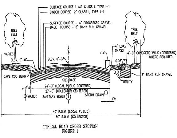
(Ord. of 6-26-03)
Note(s)—Former § 23-47.
Sec. 23-58. Street signs and streetlights.
a. Street signs. Street signs, with the approved street name, and any other signs as required by the planning board (directional or informational), shall be installed by the developer immediately after grading and preparation of the subbase for the street (see appendix). Street signs shall be of the size, type and number specified by the director of public works.
b. Streetlights. The planning board, acting with a recommendation from the chief of police and the director of public works, shall determine if a proposed development or subdivision requires streetlights. When required, the applicant shall present a plan for their installation, following consultation with the chief of police and the director of public works. The planning board shall review the plan and make a determination as to the number and placement of streetlights. Until the town council accepts all streets in the development, the costs to install, maintain and operate the streetlights shall be the responsibility of the developer. The developer shall prepay the town an amount comprised of these expenses, including an estimated utility bill for 18 months, or longer, to be deposited by the town clerk in an escrow account. The planning board may also make recommendations to the town council for the installation of streetlights in existing developments and along town-accepted streets.
(Ord. of 6-26-03)
Note(s)—Former § 23-48.
Sec. 23-59. Sidewalks, pedestrian ways, bicycle paths and driveways.
a. Generally. Sidewalks and pedestrian ways shall be located as required for safety. Where required, walks shall be placed parallel to the street, with exceptions permitted to preserve natural features or to provide visual interest. In rural residential developments and land development projects, walks may be placed away from the road system with the permission of the planning board. Sidewalks and pedestrian ways shall be constructed in accordance with the specifications contained in appendix A, construction specifications.
b. Sidewalks. Sidewalks shall be provided as required by the planning board. When required, they shall be installed on one side of the road only, be a minimum of four feet in width and separated from the roadway by a vegetated strip as detailed in figure 1 [following section 23-57]. The criteria used by the planning board in determining the need for sidewalks includes the following:
(1) The subdivision is located within an area within one mile of a public or private school;
(2) The subdivision is located in reasonable proximity to major public or private facilities such as churches, shopping areas, playgrounds, etc., where there is a reasonable likelihood that pedestrian traffic would result; or
(3) The subdivision is located within an area with high vehicular traffic volumes and/or high density residential development where there would be a likelihood of significant danger to pedestrians.
c. Pedestrian rights-of-way. The planning board may also require provisions for pedestrian rights-of-way, where it is deemed appropriate to the design of a development. All such rights-of-way shall be ten feet in width and the board may require that such pedestrian ways be paved where it is deemed to be in the public interest.
d. Bicycle paths. Bicycle paths shall be incorporated into the proposed development or subdivision where necessary to extend an existing bicycle path; to intersect with proposed state bicycle facilities; to connect adjacent developments where vehicular connections would be impractical; or where adjacent or nearby schools, recreation areas or other similar facilities would be likely to generate significant bicycle traffic.
e. Driveways. Driveways which access development streets and/or which are to become town accepted streets, shall be constructed and paved in accordance with the specifications for street construction in Appendix A for either a minimum length of eight feet or for that portion within the town street right-of-way. Prior to the start of any such construction, approval of the design shall be obtained from the director of public works.
(Ord. of 6-26-03)
Note(s)—Former § 23-49.
Sec. 23-60. Blocks and lots.
a. In residential subdivisions with substantially parallel streets, blocks shall not be greater than one-fourth mile in length nor consist of more than eight lots in length.
b. In general, the side lines of lots should be perpendicular to the street.
c. All lots shall front on an accepted street, or street approved by the planning board.
d. All lots shall be designed so as to contain the minimum land area required by the town zoning ordinance exclusive of land unsuitable for development as defined in section 23-54. The suitable land area of each lot must be at least 65 percent contiguous, and of a configuration so as to meet all setback requirements of the zoning ordinance.
(Ord. of 6-26-03)
Note(s)—Former § 23-50.
Sec. 23-61. Control of stormwater runoff.
Stormwater runoff is responsible for transporting eroded sediments, nutrients, petroleum hydrocarbons, heavy metals, pesticides, road salts, pathogens and other pollutants to receiving waters. To reduce the impact of these pollutants and to control the flooding impact of stormwater runoff, the requirements of this section for drainage system design shall be met. Drainage systems shall be constructed in accordance with the specifications contained in the appendix.
I. General standards.
a. Impervious surfaces and site disturbance should be reduced to the greatest extent possible, and as much natural undisturbed vegetation as possible shall be retained.
b. Natural drainage patterns shall be maintained whenever possible.
c. The developer is encouraged to incorporate natural elements into the drainage design whenever possible. These elements (grass swales, wet basins) collect and transport stormwater, but also mitigate pollution, reduce sedimentation and provide visual amenities and potential wildlife habitat.
d. Storm drains, culverts, catchbasins and related facilities shall be designed to ensure adequate drainage at all low points along streets, to prevent additional water from flowing onto adjacent properties and to intercept stormwater runoff along streets at intervals reasonably related to the extent and grade of the area being drained.
e. A proposed drainage system shall be designed to accommodate stormwater such that post-construction conditions do not result in peak runoff increases in rate or volume from pre-construction conditions.
f. Lots/assigned areas/parcels shall be prepared and graded consistent with drainage within the development and in such a manner that development of the lots shall not cause detrimental drainage on another lot, adjacent parcels or areas outside the development.
g. Where any part of a drainage system is proposed for location outside the public street right-of-way, provisions shall be made for future maintenance and approved by the planning board.
h. All necessary easements to off-street watercourses shall be obtained by the developer.
i. Adequate physical access for maintenance purposes shall be provided in and around all drainage facilities. When determined to be necessary by the planning board, a detention pond shall be provided with a suitable means of protection around its perimeter, such as fencing or vegetation.
II. Stormwater management plans.
a. A stormwater management plan must be submitted for all proposed land development projects and subdivisions as required by the appropriate submittal requirements. The principal emphasis of stormwater management shall be the reduction of land disturbance and impervious surfaces, the preservation of vegetated buffers, and the use of proven techniques to control peak discharge rates, reduce runoff volumes and improve water quality.
b. The design of a stormwater management plan and drainage system shall be undertaken by a professional engineer. The stormwater drainage calculations, runoff rates and system design shall be based on the application of the appropriate method as follows:
(1) Rational method. This method is the preferred method for small systems of one acre or less, where no wetlands, ponds or other storage depressions are present and where drainage is towards the point of analysis. It is also the preferred technique for pavement drainage calculations needed to size drainage components in highway, industrial and commercial applications.
(2) TR-55. This is the preferred method for calculating runoff volumes, peak discharge rates and flood storage requirements for site developments between one acre and 2,000 acres.
(3) TR-20. This method is used for large complex watersheds, multiple watershed projects and systems beyond the scope of the TR-55 method.
(4) [Other methods.] Other methods may be accepted by the planning board, provided the applicant submits all necessary information for the review process.
c. A stormwater management plan shall be based upon the Rhode Island Stormwater Design and Installation Standards Manual (except as modified by these regulations) and must contain the following:
(1) A description of best management practices (BMPs) for the proposed development. These BMPs must be illustrated on detailed site plans and described within the written plan. Structural BMPs shall be designed as amenities for the development which add open space, recreation, wildlife habitat and screening between different land uses, while also providing peak discharge rate control and pollutant reduction.
(2) A maintenance schedule for each BMP.
(3) A written narrative that describes the proposed measures to reduce peak discharge rates, maintain sheet flow (where possible) and improve water quality. This narrative must demonstrate that all flood control and water quality performance will be met.
(4) An assessment of the structural integrity of the proposed stormwater system to withstand discharge from a two- to 100-year storm.
d. Where deemed appropriate, the planning board may require land disturbance envelopes for each lot as part of the stormwater management plan.
III. Stormwater performance standards and requirements.
a. Section 2 of the State of Rhode Island Stormwater Design and Installation Standards Manual is incorporated by reference into these performance standards.
b. A continuous drainage system will be installed and connected to a natural or manmade watercourse or to an existing piped storm drainage system. The ultimate destination of such continuous drainage is a permanent natural body of water or wetland. Where the planning board determines that such ultimate destination is impractical, the board shall require the construction of a retention area capable of accommodating proposed stormwater volumes based on a 100-year frequency rainfall.
c. The discharge from any stormwater facility must be conveyed through properly constructed watercourses to provide for nonerosive flows during all storm events. The proposed stormwater conveyance system, consisting of open channels, catchbasins, pipes, etc., shall, at a minimum, accommodate runoff from a 25-year frequency storm.
d. Proposed projects must control and maintain post-development peak discharge rates from the two-, ten- and 25-year storm events at predevelopment levels.
e. When deemed necessary by the planning board, downstream analysis of the 100-year storm event shall be required. Where warranted, control of the peak discharge rate for the 100-year storm shall be required to mitigate downstream impacts.
f. Where detention, retention and infiltration systems are required, their design shall provide that, under a 50-year frequency storm, peak runoff and stream flows at the boundaries of the development will be no higher following development than prior to development.
g. At a minimum, 80 percent of total suspended solids (TSS), as calculated on an average annual basis, must be removed from the development's stormwater. A volume calculated by multiplying one inch by the impervious surface area contained within the contributing drainage area, and incorporated into a properly designed, installed and maintained BMP will result in the above reduction in TSS. Additional volumes must be incorporated into the BMP to store expected sediment loads. The additional sediment volume must be consistent with the individual BMP maintenance schedule.
h. Wet ponds must have a permanent pool volume equal to the water quality volume described in [subsection] III.g above.
i. Extended detention dry ponds must detain the water quality volume over a 36-hour period (brim drawdown time).
j. Infiltration methods must be designed to retain and exfiltrate the water quality volume over a maximum 72-hour period.
k. Where site conditions restrict the construction of BMPs that will meet these design criteria, the applicant must explain within the stormwater plan narrative how the 80 percent TSS removal rate will be obtained.
(Ord. of 6-26-03)
Note(s)—Former § 23-51.
Sec. 23-62. Water service.
a. Where water is available either at the property line or across the street from a development, water mains, with hydrants, valves and other fittings, shall be constructed and installed within the development as necessary to provide all lots/areas therein with adequate water supply for domestic and fire protection uses, according to the construction standards and specifications of the applicable water/fire district.
b. Where the development adjoins undeveloped property, provisions shall be made for the proper projections of the system by continuing appropriate water mains to the exterior boundaries of the development, at such size and grade as will allow for these projections, except, however, that the extension of water mains will not be required where the distance of such extension would be ten feet or greater outside of any proposed paved area.
c. Service connections shall be provided to each lot/area shown on the approved final plan, unless there is specific approval from the appropriate water/fire district to deviate from this requirement due to unusual topographic or technical difficulties.
d. The water system shall be laid out to the satisfaction of the planning board and the respective water/fire district. In general, water lines shall be installed within the northerly and easterly shoulders of the proposed street, unless the developer can justify otherwise due to conflict with other utilities. In residential areas, hydrants shall be installed at a spacing not to exceed 500 feet of vehicular travel distance and as close to a dividing lot line (if a subdivision) as possible. In commercial and industrial areas, hydrants shall be at a spacing not to exceed 300 feet of vehicular travel distance. In addition, no residential structure shall be more than 500 feet, and no commercial or industrial structure shall be more than 300 feet, from at least one hydrant. The proposed locations of fire hydrants and available fire flows shall be submitted to the fire chief for approval. The adequacy of the installed water system for domestic and firefighting needs shall be confirmed by hydrant pressure and flow tests under demand conditions.
e. Cisterns. In the event the planning board, after careful deliberation and considering all relevant factors before it, resolves that a proposed subdivision or land development cannot connect to a public water supply, then the proposed subdivision or land development shall provide underground water cisterns for fire protection purposes to be approved in writing by the Tiverton Fire Chief or his/her designee, in conformance with the following minimum requirement.
| Number of Lots/Units | Number of Cisterns |
| Less than three | 0 |
| Three to five | 1 |
| Six to ten | 2 |
| Eleven or more | To be determined by the fire chief |
The size and location of the cistern(s) shall be determined by the fire chief or his/her designee prior to preliminary plan approval of the subdivision or land development. Cisterns shall not be located within the public right of way.
Repairs to and maintenance of approved tanks will not be the responsibility of the Tiverton Fire Department or the Town of Tiverton. All repairs shall be the responsibility of the homeowners association of that subdivision or land development, or other legal entity as described in the final plan decision and/or other recorded legal documents.
(Ord. of 6-26-03; Ord. of 9-13-11)
Note(s)—Former § 23-52.
Sec. 23-63. Utilities service.
All electrical, gas, telephone and other utility mains, including service connections, shall be constructed and installed within the development as necessary to provide all lots or development sites therein adequate supply for domestic or other use. Each utility system shall be laid out to the satisfaction of the planning board and the respective utility. The planning board may require underground utilities. The installation of these systems, including the method of construction and the material used, shall conform to the current standard specifications of the respective utility and those contained in applicable state codes or laws.
(Ord. of 6-26-03)
Note(s)—Former § 23-63.
Sec. 23-64. Landscaping/tree preservation.
Landscape/tree preservation plan. The planning board shall require that a landscape plan be submitted to the board when it determines that existing landscaping is insufficient; where the site of the proposed development has been disturbed so as to require significant new vegetation; or where additional landscaping is necessary to protect, preserve or enhance significant visual characteristics of the site. If a landscape/tree preservation plan is required by the board, the applicant shall be advised of this requirement at the preliminary plan stage of a minor land development or subdivision, and at the master plan stage of a major land development or subdivision. If said plan is required, it shall be stamped by a registered landscape architect.
(Ord. of 6-26-03)
Note(s)—Former § 23-54.
Sec. 23-65. Viewshed protection.
Preliminary and final plans must evaluate the impact of the proposed development on scenic viewsheds. To the extent practicable, and consistent with the intended function of the proposed development, any impairment of viewshed quality must be avoided or minimized. New developments should maintain existing viewsheds by avoiding the destruction of existing wooded/vegetative buffers along arterial and limited-access streets. In addition, visual buffers between new structures and such streets shall be provided. Visual buffers between residential and commercial/industrial areas shall be provided as well.
(Ord. of 6-26-03)
Sec. 23-66. Soil erosion and sediment control.
Soil erosion and sediment control plan. A plan to control erosion and sedimentation during construction, consistent with the requirements of the current town soil erosion and sediment control ordinance, chapter 65 of the Town Code, shall be submitted.
(Ord. of 6-26-03)
Note(s)—Former § 23-55.
Sec. 23-67. Off-site improvements.
a. As a condition of final approval, the planning board may require a developer to construct reasonable and necessary improvements located off of the proposed land being developed or subdivided. Such improvements are those clearly and substantially related to the land development or subdivision being proposed, and are necessary to mitigate the impacts which are attributable to the proposed development.
b. Off-site improvements may include, but are not limited to, the following:
(1) Sanitary sewers;
(2) Water supply systems;
(3) Drainage systems;
(4) Roadways; and
(5) Sidewalks.
c. The planning board shall provide in its resolution of final approval the basis for requiring such off-site improvements. The mitigation required as a condition of approval must be related to the significance of the identified impact. All required off-site improvements must reflect the character defined for the neighborhood or district by the Tiverton comprehensive plan.
(Ord. of 6-26-03)
Note(s)—Former § 23-56.
Sec. 23-68. Additional requirements.
The developer shall, at his own expense, construct the following improvements as required by the planning board and according to the specifications of the director of public works or town engineer.
a. Curbs. Curbs shall be provided as required by the planning board. As a general rule curbing will be discouraged in low density areas as it tends to concentrate stormwater runoff. When required, curbing in residential areas shall be Cape Cod berm. Curbing in commercial or industrial areas shall be either granite, precast concrete or Cape Cod berm. The type and minimum height of the curbing shall be as directed by the planning board, with a recommendation by the director of public works or town engineer.
b. Guardrails. Guardrails may be required by the planning board where there are hazards such as a dropoff with a slope greater then 50 percent, water bodies adjacent to the shoulder, or other hazardous conditions. Wooden guardrails meeting the current construction and safety standards are preferred, particularly in low density developments.
c. Monuments. Monuments meeting the specifications of the Rhode Island Society of Professional Land Surveyors Procedural and Technical Standards shall be placed where angles are turned in the survey, at street line intersections, at bearings and distances of chords where curves are involved, and at such other locations as the planning board may designate. All monuments shall be set flush with the finished grade. Granite or concrete monuments may be required by the planning board.
(Ord. of 6-26-03)
Note(s)—Former § 23-57.
ARTICLE XI. GUARANTEE OF PERFORMANCE AND INSPECTION AND MAINTENANCE OF IMPROVEMENTS
Sec. 23-69. Definition and purpose.
a. An improvement guarantee is a security instrument accepted by the town to ensure that all improvements, facilities or work required under these regulations, or as a condition of approval of a land development or subdivision plan by the planning board, will be completed in compliance with the approved plans and specifications. The term "improvements" as used herein may be public improvements, as well as private or other improvements required under these regulations. Only those improvements designated as public will the town ultimately accept for ownership and maintenance responsibility.
b. An improvement guarantee shall consist of three parts, the legal agreement binding the developer to perform the required improvements, the construction surety, which is money or security the developer puts up to guarantee the agreement, and the maintenance surety, which is funding provided to the town for use in performing maintenance of storm water control facilities that may or may not be ultimately accepted by the town for ownership.
(Ord. of 6-26-03)
Note(s)—Former § 23-58.
Sec. 23-70. Improvement guarantee requirements.
a. Prior to the approval of any land development or subdivision plan by the planning board, and prior to the recording of any subdivision plats, the planning board shall approve agreements with the developer for the completion of all required improvements. Such agreements shall take the form of one of the following:
(1) Completion of actual construction of all improvements without improvement guarantees;
(2) Improvement guarantees; or
(3) A combination thereof.
b. Where improvements are constructed without a financial guarantee, the work is to be completed prior to final approval of the development or subdivision plan. All construction shall be inspected and approved according to the procedures contained in section 23-72 and shall follow the time periods specified in section 23-74. Following certification in writing of the final completion of all improvements by the director of public works, or the town engineer, and the receipt of letters from the appropriate water/fire district and other relevant utility companies stating that all constructed improvements are satisfactory, the final plat shall be approved by the planning board. The board shall then recommend to the Tiverton town council that all public improvements be accepted by the town. Upon such acceptance by the town council, the final plat may be recorded as provided in section 23-49, at which time the lots within the development may be transferred or sold.
c. In the cases of developments which are being approved and constructed in phases, the planning board shall specify improvement guarantee requirements related to each phase.
(Ord. of 6-26-03)
Note(s)—Former § 23-59.
Sec. 23-71. Procedure for setting and use of improvement guarantees.
a. Construction improvement guarantees shall be in an amount and with all necessary conditions to secure for the town the actual construction and complete installation of all required improvements within three years. The amount shall be based on cost estimates for the required public improvements, as provided in writing from the director of public works, or the town engineer, to the planning board. The board may fix the guarantee in a reasonable amount in excess of the estimated costs to anticipate future economic or construction conditions.
b. The construction surety shall be in the form of a certified check, bank book or letter of credit payable to the Town of Tiverton. Said check, bank book or letter of credit will be availed of by the town in the event of default by the developer, and shall be held by the town until release by the planning board.
c. The administrative officer, in coordination with the director of public works or town engineer, shall be responsible for monitoring the status of all ongoing development with regard to their construction, inspection and performance guarantee status, and will advise the planning board appropriately.
d. The Town of Tiverton shall hold the developer and construction surety in default of guarantee should one or more of the following occur:
(1) Failure to meet all specifications for construction of required improvements to the land;
(2) Failure to properly notify the director of public works or town engineer of the initiation and completion of all phases of construction of required improvements to the land, or to obtain the necessary inspections of these improvements as required in section 23-72;
(3) Failure to protect existing improvements and/or properly repair such improvements should damage occur during construction;
(4) Failure to clean debris from the site and adjacent areas upon completion of the construction; or
(5) Failure to complete required improvements to the land within the time prescribed, or within any extension granted by the planning board.
e. Upon notification of default by the director of public works or town engineer, the planning board shall take appropriate action against that portion of the construction surety necessary to correct the deficiencies for which the developer is deemed to be in default, and shall cause the required improvements to be completed in a satisfactory manner.
f. The maintenance surety shall be in an amount sufficient to perform inspection and maintenance consistent with the procedures contained in section 23-72, for a period of time as deemed appropriate by the planning board, but not to exceed five years. The maintenance surety shall be in the form of a certified check, bank book or letter of credit payable to the town. The town shall have sole control over the funds thereafter for use in executing the maintenance of stormwater control facilities.
(Ord. of 6-26-03)
Note(s)—Former § 23-60.
Sec. 23-72. Inspection of improvements.
a. One complete set of all construction plans, profiles, cross sections or other working drawings of required improvements to the land shall be submitted to the director of public works or town engineer prior to the start of any construction; these plans shall consist of either the final plans approved by the planning board or plans approved by the board for construction.
b. Within 48 hours of the commencement of the construction of required improvements, the director of public works, or the town engineer, shall be so notified by certified mail. A copy of the letter shall also be sent to the planning board. The director of public works or the town engineer shall be further notified verbally at the following construction phases:
(1) Upon completion of clearing, grubbing, and excavation, but prior to placement of any suitable fill to reach subgrade;
(2) Upon completion of the installation of the underground utilities and drainage, but prior to backfilling;
(3) Prior to the installation of gravel on the subgrade for streets and sidewalks;
(4) Upon completion of the gravel base for streets and sidewalks at two stages: the placement of the bank run gravel, and the placement of the crushed gravel;
(5) Prior to the initiation of each application of bituminous concrete, [and] the pouring of concrete in sidewalks;
(6) Prior to placement of curbing; and
(7) At such time as materials and other items of work are ready for inspection such as the installation of bounds, loam and seeding, general cleanup or other items pertaining to the development.
c. Upon completion of the required improvements, the developer shall notify the director of public works, or the town engineer, who shall conduct a detailed inspection of the completed work. Upon determining that the improvements have been completed in a satisfactory manner, the director or town engineer shall prepare a written report to be transmitted to the planning board stating that such improvements have been constructed or installed.
d. Improvements initiated prior to planning board approval shall be at the risk of the applicant/developer.
(Ord. of 6-26-03)
Note(s)—Former § 23-61.
Sec. 23-73. Submission of as-built drawings.
Upon the completion of construction and the installation of all required improvements to the land, with the exception of the top coat for all roads, the developer shall furnish two complete sets of as-built drawings of such improvements, one to the director of public works and one to the planning board. All as-built drawings shall contain the information specified in attachment 10 and shall be signed by a registered land surveyor and a registered professional engineer. Upon the final completion of all construction, the developer shall ensure that the as-built drawings are current and on file at the offices of the planning board and the director of public works.
(Ord. of 6-26-03)
Note(s)—Former § 23-62.
Sec. 23-74. Acceptance of improvements and release of surety.
a. Upon the completion of all required improvements with the exception of the top coat for all roads, and the submittal of the written report by the director of public works or town engineer to the planning board, the developer shall be eligible for a portion of the surety. The amount to be released shall be based upon a cost estimate of the remaining work prepared by the director of public works or town engineer; said estimate shall be doubled in value and this amount of the original surety retained. After a minimum period of one year, which shall include one continuous winter season, the developer shall install the top coat under the proper notification and inspection procedures described herein.
b. Upon inspection and approval of the construction of the top coat and all other improvements by the director of public works or town engineer, and receipt of the written report by the planning board, the board shall notify the developer that he will be eligible for the release of the remaining surety after a minimum period of one year, which shall include one continuous winter season.
c. Upon final inspection and approval of the roads by the director of public works or town engineer, in writing to the planning board, the board will recommend to the Tiverton town council that all public improvements be accepted by the town. Upon acceptance of the improvements by the town council, the remaining surety shall be released. The full release of the surety shall be conditioned upon the following:
(1) The faithful completion of all required improvements within a three-year period, as well as the expiration of all required waiting periods as described below;
(2) Payment of all invoices issued by the planning board to cover the cost of the required inspections;
(3) Receipt by the planning board of copies of any department of environmental management and/or coastal resources management council final inspection reports or approvals;
(4) Receipt by the planning board of letters from the appropriate water district and other relevant utility companies stating that all constructed improvements related to the respective water district or utility are satisfactory;
(5) Submittal of accurate as-built drawings; and
(6) Acceptance of all public improvements by the Town of Tiverton.
d. If, due to circumstances beyond the control of the developer, the required improvements are not completed within the prescribed three-year period, the planning board may grant a time extension. During such time extension, the guarantee shall remain in full force.
e. The release of a maintenance surety, minus any allocated funds, shall occur when the director of public works or town engineer determines that the storm water control facility has been operating in a satisfactory manner for a minimum period of one year, or at such time when the town accepts responsibility for the facility. However, such remaining surety may not be held for a period of longer than five years from the date at which it was issued. If it is determined by the planning board, based upon the report of the director of public works or town engineer, that a stormwater control facility cannot be properly maintained without the town making use of the funds available from the maintenance surety, the board shall require that responsibility of the facility be transferred to the town with the costs of maintenance assigned to the property owners.
(Ord. of 6-26-03)
Note(s)—Former § 23-63.
ARTICLE XII. AMENDMENT OF REGULATIONS
Sec. 23-75. Procedure for amendment.
a. These land development and subdivision review regulations may be amended by the Tiverton Planning Board, following a public hearing before the board. At this hearing, opportunity shall be given to all persons interested to be heard upon the matter of the proposed regulations.
b. All amendments shall be consistent with all provisions of the Land Development and Subdivision Review Enabling Act of 1992, and with the Tiverton comprehensive plan and the Tiverton zoning ordinance.
(Ord. of 6-26-03)
Note(s)—Former § 23-64.
Sec. 23-76. Public hearing and notice requirements.
The planning board shall first give notice of the public hearing by publication of notice in a newspaper of general circulation within the Town of Tiverton at least once each week for three successive weeks prior to the date of the hearing, which may include the week in which the hearing is to be held. The newspaper notice shall be published as a display advertisement, using a type size at least as large as the normal type size used by the newspaper in its news articles, and shall include the following:
a. The date, time and place of the hearing;
b. A statement that amendment of the land development and subdivision review regulations is under consideration;
c. A statement of the proposed amendment in its entirety, or a summary of the matter under consideration;
d. The location(s) where and the times when a copy of the proposed amendment may be obtained or examined and copied; and
e. A statement that the proposed amendment may be altered or amended prior to the close of the public hearing without further advertising, as a result of further study or because of the views expressed at the public hearing, and that any such alteration or amendment must be presented for comment in the course of the public hearing.
(Ord. of 6-26-03)
Note(s)—Former § 23-65.
Sec. 23-77. Written notice requirements.
Written notice, which may be a copy of the newspaper notice, shall be mailed by first class mail at least two weeks prior to the hearing, to the following:
a. The Associate Director of the Division of Planning of the Rhode Island Department of Administration.
b. The city or town planning board of any municipality where there is a public or quasipublic water source, or private water source that is used or is suitable for use as a public water source, located within 2,000 feet of the town boundaries.
c. The governing body of any state or municipal water department or agency, special water district, or private water company that has riparian rights to a surface water resource and/or surface watershed, or groundwater resource, that is used or is suitable for use as a public water source located within either the town or 2,000 feet of the town boundaries, provided, however, that a map survey has been filed with the building official as specified in article XIX, section 4.d, of the Tiverton zoning ordinance.
(Ord. of 6-26-03)
Note(s)—Former § 23-66.
ARTICLE XIII. APPEALS[4]
Sec. 23-78. Right of appeal.
Any party aggrieved by any decision of the planning board, technical review committee, administrative officer, or board of appeal, may appeal such decision in accord with the provisions of this article.
(Ord. of 11-30-23(9))
Sec. 23-79. Appeals from decisions of the administrative officer.
a. Other than as specified in appendix B, Land Development and Subdivision Regulations, article XIII, section 23-79(b), all decisions and actions of the administrative officer shall be appealed to the board of appeal in the manner directed by this section.
b. Decisions by the administrative officer approving or denying projects under appendix B, Land Development and Subdivision Regulations, article VI and article XVI shall not be subject to this section but rather shall proceed directly to superior court as set forth in appendix B, Land Development and Subdivision Regulations, article XIII, section 23-80 (see G.L. § 45-23-71).
c. Process of appeal.
1. An appeal to the board of appeal from a decision or action of the administrative officer may be taken by an aggrieved party to the extent provided in G.L. § 45-23-67. The appeal must be taken within 20 days after the decision has been recorded in the Tiverton land evidence records and posted in the office of the Tiverton Town Clerk.
2. The appeal shall be in writing and state clearly and unambiguously the issue or decision that is being appealed, the reason for the appeal, and the relief sought. The appeal shall either be sent by certified mail, with a return receipt requested, or be hand-delivered to the board of appeal. The clerk for the board of appeal shall accept delivery of an appeal on behalf of the board of appeal.
3. Upon receipt of an appeal, the board of appeal shall require the administrative officer to immediately transmit to the board of appeal, all papers, documents and plans, or a certified copy thereof, constituting the record of the action which is being appealed.
d. Stay. An appeal stays all proceedings in furtherance of the action being appealed.
e. Hearing.
1. The board of appeal shall hold a hearing on the appeal within 45 days of the receipt of the appeal, give public notice in accord with appendix B, Land Development and Subdivision Regulations, article IV, section 23-14, of the hearing, as well as due notice to the parties of interest. At the hearing the parties may appear in person, or be represented by an agent or attorney. The board shall render a decision within ten days of the close of the public hearing. The cost of any notice required for the hearing shall be borne by the applicant.
2. The board of appeal shall only hear appeals of the actions of an administrative officer at a meeting called especially for the purpose of hearing the appeals and which has been so advertised.
3. The hearing, which may be held on the same date and at the same place as a meeting of the zoning board of review, must be held as a separate meeting from any zoning board of review meeting. Separate minutes and records of votes as required by G.L. § 45-23-70(d) shall be maintained by the board of appeal.
f. Standards of review.
1. The board of appeal shall not substitute its own judgment for that of the administrative officer but must consider the issue upon the findings and record of the administrative officer. The board of appeal shall not reverse a decision of the administrative officer except on a finding of prejudicial procedural error, clear error, or lack of support by the weight of the evidence in the record.
2. The concurring vote of three of the five members of the board of appeal sitting at a hearing, is necessary to reverse any decision of the administrative officer.
3. In the instance where the board of appeal overturns a decision of the administrative officer, the proposed project application is remanded to the administrative officer, at the stage of processing from which the appeal was taken, for further proceedings before the administrative officer and/or for the final disposition, which shall be consistent with the board of appeal's decision.
4. The board of appeal shall keep complete records of all proceedings including a record of all votes taken, and shall put all decisions on appeals in writing. The board of appeal shall include in the written record the reasons for each decision.
(Ord. of 11-30-23(9))
Sec. 23-80. Appeals to the Superior Court—Decisions of permitting authorities.
a. An aggrieved party may appeal to the Superior Court with jurisdiction over the matter:
1. A decision of the board of appeal;
2. A decision of an administrative officer made pursuant to appendix B, Land Development and Subdivision Regulations, article VI and article XVI where authorized to approve or deny an application;
3. A decision of the technical review committee, where authorized to approve or deny an application; or
4. A decision of the planning board, (collectively "permitting authority") by filing a complaint stating the reasons for the appeal within 20 days after the decision has been recorded and posted in the office of the Tiverton Town Clerk. Recommendations by any permitting authority, public body or officer under this chapter are not appealable under this section.
b. The permitting authority shall file the original documents acted upon by it and constituting the record of the case appealed from, or certified copies of the original documents, together with any other facts that may be pertinent, with the clerk of the court within 30 days after being served with a copy of the complaint.
c. When the complaint is filed by someone other than the original applicant or appellant, the original applicant or appellant and the permitting authority shall be made parties to the proceedings.
d. The appeal does not stay proceedings upon the decision appealed from, but the court may, in its discretion, grant a stay on appropriate terms and make any other orders that it deems necessary for an equitable disposition of the appeal.
(Ord. of 11-30-23(9))
Sec. 23-81. Appeals to the superior court—Amendment of these regulations.
a. An appeal of an amendment of these regulations may be taken to the superior court by filing a complaint within 30 days after such amendment has become effective. The appeal may be taken by any legal resident or landowner of the town, or by any association of residents or landowners of the town.
b. The appeal shall not stay the enforcement of these regulations, as amended, but the court may, in its discretion, grant a stay on appropriate terms, which may include the filing of a bond, and make such other orders as it deems necessary for an equitable disposition of the appeal.
c. The complaint shall set forth with specificity the area or areas in which the amendment is not consistent with the Comprehensive Planning Act, G.L. 1956, § 45-22.2-1 et seq.; the Zoning Enabling Act of 1991, G.L. 1956, § 45-45-1 et seq.; the Tiverton Comprehensive Plan or the Tiverton Zoning Ordinance.
(Ord. of 11-30-23(9))
Secs. 23-82, 23-83. Reserved.
ARTICLE XIV. LEGAL STATUS
Sec. 23-84. Severability.
If any provision of this chapter or of any rule, regulation or determination made thereunder, or the application thereof to any person, agency or circumstances, is held invalid by a court of competent jurisdiction, the remainder of the chapter, rule, regulation or determination and the application of such provisions to other persons, agencies, or circumstances shall not be affected thereby. The invalidity of any section or sections of this chapter shall not affect the validity of the remainder of the chapter.
(Ord. of 6-26-03)
Note(s)—Former § 23-72.
Sec. 23-85. Effective date.
These regulations shall take effect on December 31, 1995, and on said date all prior regulations and amendments thereto are hereby repealed.
(Ord. of 6-26-03)
Note(s)—Former § 23-73.
Sec. 23-86. Vested rights.
Under the provisions of this article, any application considered by the town shall be reviewed according to the regulations in force at the time the application received preliminary approval from the planning board. If an application is so vested, action shall be taken by the applicant or owner within six months from the date of its last review or approval by the planning board, and diligently pursued until final approval and/or recording of plans. Any proposed development or subdivision plan for which either preliminary or final approval has been granted, and for which no further action has been taken, including the recording of plats if relevant, within said six-month period, shall require the submission of an application subject to the provisions of this chapter.
(Ord. of 6-26-03)
Note(s)—Former § 23-74.
ARTICLE XV. UNIFIED DEVELOPMENT REVIEW
Sec. 23-87. Unified development review.
a. Review of projects submitted under this section shall adhere to the procedures, timeframes and standards of the underlying category of the project as listed in appendix B, Land Development and Subdivision Regulations, articles V, VI, VII, and XVI, but shall also include the following procedures:
1. Minor subdivisions and land-development projects. Except for dimensional relief granted by modification, requests for variances and/or for the issuance of special use permits related to minor subdivisions and land-development projects shall be submitted as part of the application materials for the preliminary plan stage of review or if combined, for the first stage of reviews. A public hearing on the application, including any variance and special use permit requests that meets the requirements of subsection a.4 of this section shall be held prior to consideration of the preliminary plan by the planning board. The planning board shall conditionally approve or deny the request(s) for the variance(s) and/or special use permit(s) before considering the preliminary plan application for the minor subdivision or land-development project. Approval of the variance(s) and/or special use permit(s) shall be conditioned on approval of the final plan of the minor subdivision or land development project.
2. Development plan review. Except for dimensional relief granted by modification, requests for relief from the literal requirements of the zoning ordinance and/or for the issuance of special use permits related to development plan review projects shall be submitted as part of the application materials for the first stage of review. A public hearing on the application, including any variance and special use permit requests that meets the requirements of subsection a.4 of this section shall be held prior to consideration of the preliminary plan by the planning board (see G.L. § 45-23-50(d)(1)(ii)). The planning board shall conditionally approve or deny the request(s) for the variance(s) and/or special use permit(s) before considering the preliminary plan application for the development plan review project. Approval of the variance(s) and/or special use permit(s) shall be conditioned on approval of the final stage of review of the development plan review project.
3. Major subdivisions and land-development projects.
i. Master plan. Except for dimensional relief granted by modification, requests for variances for relief from the literal requirements of the zoning ordinance and/or for the issuance of a special use permit related to major subdivisions and land-development projects shall be submitted as part of the application materials for the master plan stage of review, or if combined, the first stage of review. A public hearing on the application, including any variance and special use permit requests that meets the requirements of this section, shall be held prior to consideration of the master plan by the planning board. The planning board shall conditionally approve or deny the requests for the variance(s) and/or special use permit(s) before considering the master plan application for the major subdivision or land development project. Approval of the variance(s) and/or special use permit(s) shall be conditioned on approval of the final plan of the major subdivision or land-development project.
ii. Preliminary plan. During the preliminary plan stage of review, applicants shall have the ability to request alteration of any variance(s) and/or special use permit(s) granted by the planning board during the master plan stage of review, and/or to request new variance(s) and/or special use permit(s), based on the outcomes of the more detailed planning and design necessary for the preliminary plan. If necessary, the applicant shall submit such requests and all supporting documentation along with the preliminary plan application materials. If the applicant requests new or additional zoning relief at this stage, a public hearing on the application, that meets the requirements of subsection a.4 of this section, shall be held prior to consideration of the preliminary plan by the planning board. The planning board shall conditionally approve, amend, or deny the requests for alteration(s), new variance(s) and/or new special use permit(s), before considering the preliminary plan application for the major subdivision or land-development project. Approval of the alteration(s), new variance(s), and/or new special use permit(s) shall be conditioned on approval of the final plan of the major subdivision or land-development project. If the planning board denies the request for alteration(s), new variance(s), and/or new special use permit(s), the planning board shall have the option of remanding the application back to the master plan stage of review. Alternatively, if the planning board denies the request for alteration(s), new variance(s), and/or new special use permit(s), the applicant may consent to an extension of the decision period mandated by appendix B, Land Development and Subdivision Regulations, article VII, section 23-32 so that additional information can be provided and reviewed by the planning board.
4. Unless otherwise provided in this chapter all applications under this section shall require a single public hearing, held pursuant to subsection a.1 of this section. The public hearing must meet the following requirements:
i. Public hearing notice shall adhere to the requirements found in appendix B, Land Development and Subdivision Regulations, article IV, section 23-14 and G.L. § 45-23-42(b).
ii. The notice area for notice of the public hearing shall be to each owner within 200 feet of the perimeter of the real property proposed for development or subdivision, and notice of the public hearing shall be sent by the administrative officer to the administrative officer of an adjacent municipality if: (1) the notice area extends into the adjacent municipality; or (2) the development site extends into the adjacent municipality; or (3) there is a potential for significant negative impact on the adjacent municipality. Additional notice within watersheds shall also be sent as required in G.L. §§ 45-23-53(b) and (c).
iii. Public notice shall indicate that dimensional variance(s), use variance(s) and/or special use permit(s) are to be considered for the subdivision and/or land-development project.
iv. The cost of all public notice is to be borne by the applicant.
5. Decision. The time periods by which the permitting authority must approve, approve with conditions or deny requests for variances and special use permits under the unified development review provisions of a zoning ordinance shall be the same as the time periods by which the planning board must make a decision on the applicable review stage of the underlying type of project under review.
6. The expirations period of an approval of a variance or special use permit granted under this section shall be the same as those set forth for the underlying review phase of the type of project under review.
7. Decisions under this section, including requests for the variance(s) and/or special use permits that are denied by the planning board may be appealed pursuant to appendix B, Land Development and Subdivision Regulations, article XIII and G.L. § 45-23-71.
(Ord. of 11-30-23(14))
ARTICLE XVI. DEVELOPMENT PLAN REVIEW
Sec. 23-88. Applicability.
a. The following categories of projects shall be subject to the provisions of this chapter unless the project would be reviewed as a minor or major land development or subdivision. If there is a conflict as to which type of application should be filed, the application shall be reviewed as a minor or major land development or subdivision, as the case may be:
1. Industrial and commercial development.
2. Residential development, which includes, elderly housing facilities, such as a nursing home, retirement residence or assisted living facility, a manufactured home elderly community, an age restricted mixed use community development, or a multi-family structure or structures.
3. A change in use at the property where no extensive construction of improvements is sought.
4. An adaptive reuse project located in a commercial zone where no extensive exterior construction of improvements is sought.
5. An adaptive reuse project located in a residential zone which results in less than nine residential units.
6. Development in a designated urban or growth center.
7. Institutional development design review for educational or hospital facilities.
8. Development in a historic district.
b. Permitting authority. The administrative officer shall decide whether to approve an administrative development plan review project. The planning board shall decide whether to approve a Formal development plan review project.
c. Development plan review consists of two review processes: administrative and formal.
1. Administrative development plan review consists of one stage of review and the authorized permitting authority is the administrative officer. The following activities are subject to administrative development plan review:
i. A change in use at the property where there is neither a change in the footprint of the existing structure(s) nor an increase in the parking provided, and where the project does not require a waiver under appendix B, Land Development and Subdivision Regulations, article XVI, aection 23-89.
2. Formal development plan review consists of the preliminary stage and final stage of review. The authorized permitting authority is the planning board. All projects identified in appendix B, Land Development of and Subdivision Regulations, article XVI, section 23-88 that are not classified for administrative development plan review shall be subject to formal development plan review.
(Ord. of 11-30-23(4))
Sec. 23-89. Waivers.
a. Requirements for development plan review approval may be waived where there is a change in use or occupancy and no extensive construction or improvements are sought. The waiver may be granted only by a decision by the planning board, finding that the use will not affect existing drainage, circulation, relationship of buildings to each other, landscaping, buffering, lighting and other considerations of development plan approval, and that the existing facilities do not require upgraded or additional site improvements.
1. The application for a waiver of development plan approval review shall be in writing and include documentation on prior use of the site, the proposed use, and its impact. The application for a waiver shall be filed with the project application.
b. The planning board may grant waivers of design standards.
1. Application for waiver of a design standard shall be in writing and shall specifically identify the standard(s) which the applicant seeks to have waived along with a specifically stated rationale to support the request. The application for a waiver shall be filed with the project application.
(Ord. of 11-30-23(4))
Sec. 23-90. Application requesting relief from the zoning ordinance.
a. Applications under this article which require relief that qualifies only as a modification shall first proceed by filing an application and a request for a modification to the zoning enforcement officer pursuant to appendix A, Zoning, article VI, section 3. If such modification is granted the application shall then proceed to be reviewed by the designated permitting authority as determined in this article.
1. An application under this article concurrently seeking a modification pursuant to appendix A, Zoning, article VI, section 3, shall not be deemed complete without the modification request first being granted, or denied, as the case may be.
2. If the modification is denied or an objection is received as set forth in appendix A, Zoning, article VI, section 3, such application shall proceed under unified development review and be reviewed by the planning board pursuant to the provisions of appendix B, Land Development and Subdivision Regulations, article XV.
b. Applications under this article which require relief from the literal provisions of the zoning ordinance in the form of a variance or special use permit, shall be reviewed by the planning board under unified development review pursuant to the provisions of appendix B, Land Development and Subdivision Regulations, article XV, and a request for review shall accompany the preliminary plan application.
(Ord. of 11-30-23(4))
Sec. 23-91. Submission requirements.
a. Any applicant requesting approval of a proposed development under this article, shall submit to the administrative officer the items required by the checklist.
b. Requests for relief from the literal requirements of the zoning ordinance and/or for the issuance of special use permits or use variances related to projects qualifying for development plan review shall be submitted and reviewed under unified development review.
(Ord. of 11-30-23(4))
Sec. 23-92. Certification.
a. All applications under this article shall be certified, in writing, complete or incomplete by the administrative officer within 25 days. If no street creation or extension is required, and/or unified development review is not required, the application shall be certified complete or incomplete by the administrative officer within 15 days.
b. The running of the time period set forth in this section will be deemed stopped upon the issuance of a written certificate of incompleteness of the application by the administrative officer and will recommence upon the resubmission of a corrected application by the applicant. However, in no event will the administrative officer be required to certify a corrected submission as complete or incomplete less than ten days after its resubmission.
c. If the administrative officer certifies the application as incomplete, the officer shall set forth in writing with specificity the missing or incomplete items.
(Ord. of 11-30-23(4))
Sec. 23-93. Application review and decision.
a. Administrative development plan review. An application shall be approved, denied, or approved with conditions within 25 days of the certificate of completeness or within any further time that is agreed to in writing by the applicant and administrative officer.
b. Formal development plan review.
1. Preliminary plan. The planning board will hold a public hearing in accord with the requirements of appendix B, Land Development and Subdivision Regulations, article IV, section 23-14. The planning board will approve, deny, or approve with conditions, the preliminary plan within 65 days of certification of completeness, or within any further time that is agreed to by the applicant and the permitting authority.
2. Final plan. For formal development plan approval, the planning board shall delegate final plan review and approval to the administrative officer. The officer will report its actions in writing to the planning board at its next regular meeting, to be made part of the record. Final plan shall be approved or denied within 45 days after the certification of completeness, or within a further amount of time that may be consented to by the applicant, in writing.
3. The administrative officer may combine the stages of review for formal development plan review, providing that the submission requirements of both stages of review are met by the applicant to the satisfaction of the administrative officer.
c. Failure to act. Failure of the permitting authority to act within the period prescribed constitutes approval of the preliminary plan and a certificate of the administrative officer as to the failure to act within the required time and the resulting approval shall be issued on request of the application.
d. Vested rights. Approval of development plan review shall expire two years from the date of approval unless, within that period, a plat or plan, in conformity with approval, and as defined in this act, is submitted for signature and recording. Validity may be extended for an additional period upon application to the administrative officer or permitting authority, whichever entity approved the application, prior to the approval expiring, upon a showing of good cause.
e. Modifications and changes to plans.
1. Minor changes to the plans approved at any stage of the development plan review process may be approved administratively, by the administrative officer, whereupon final plan approval may be issued. The changes may be authorized without an additional planning board meeting, at the discretion of the administrative officer. All changes shall be made part of the permanent record of the project application. This provision does not prohibit the administrative officer from requesting recommendations from either the technical review committee or the permitting authority. Denial of the proposed change(s) shall be referred to the permitting authority for review as a major change. Minor changes shall include:
i. Amendments to utility plans which are acceptable to the public works director, planning board consulting engineer and to the appropriate utility company;
ii. Lot line revisions which can be reviewed and approved as an administrative subdivision;
iii. Amendments to grading plans or drainage plans which are acceptable to the public works director and planning board consulting engineer which do not require approval of any state or federal reviewing authorities;
iv. Amendments to construction plans which are required because of unforeseen physical conditions on the parcel being subdivided;
v. Modifications to any construction plans for off-site improvements which are acceptable to the public works director; or
vi. Modifications which are required by outside permitting agencies such as, but not limited to, the state department of environment management, the coastal resources management council, and the state department of transportation.
2. Major changes to the plans approved at any stage may be approved only by the planning board and must include a public hearing with notice to abutters within 200 feet of the perimeter of the property at least 14 days prior to the hearing. The administrative officer shall notify the applicant in writing within 14 days of submission of the plan application if the administrative officer determines the change to be a major change of the approved plans. Major changes include all those which are not deemed minor as well as the following:
i. Changes which would have the effect of creating additional lots or dwelling units for development;
ii. Changes which would be contrary to any applicable provision of the zoning ordinance or which require a variance or special use permit from the zoning board of review; or
iii. Changes which may have significant negative impacts on abutting property or property in the vicinity of the proposed subdivision or land development project.
f. Appeal. A decision under this section shall be considered an appealable decision. See, appendix B, Land Development and Subdivision Regulations as well as G.L. § 45-23-71.
(Ord. of 11-30-23(4))
Sec. 23-94. Design standards.
a. The design standards include both site and building design standards as described below.
b. Site design standards: The permitting authority shall apply the improvement standards contained in appendix B, Land Development and Subdivision Regulations, article X, with particular consideration given to section 23-61, Control of stormwater runoff, and section 23-66, Soil erosion and sediment control, where applicable, to projects located in all zoning districts.
In addition, the permitting authority shall apply the following standards:
1. General site standards:
i. Buildings and site improvements should be done so as to minimize changes to existing topography and the loss of existing mature vegetation.
ii. Wetlands and significant natural features should be maintained in an undisturbed form, the potential for flooding shall not be increased, and stormwater entry and discharge points should be designed so as to minimize erosion.
2. Circulation, parking and traffic control standards:
i. The layout and design of all means of vehicular and pedestrian circulation, including interior drives, parking areas and walkways, shall provide for safe interior circulation and separation of pedestrian, vehicular and service traffic.
ii. The number of site entrances should be the minimum necessary for effective traffic control, and sharing of access driveways and parking areas by adjoining properties should be considered where possible.
iii. Provisions for pedestrian movement, in the form of sidewalks or walkways, shall allow for safe access between parking areas and retail establishments.
3. Landscaping standards:
i. Buffering in the form of walls, fencing, shrubs, trees or other appropriate screening techniques may be required to shield neighboring properties, particularly residential areas, from adverse effects.
ii. Parking lots shall conform to all applicable site and landscaping requirements contained in paragraph (d) of article X, Special Provisions, section 1, Parking regulations.
iii. Visual screening of refuse areas, service and storage yards and exterior work areas shall be accomplished by use of walls, appropriate fencing, plantings, visually compatible outbuildings or a combination of these.
iv. Mechanical equipment and utility hardware on the roof or ground adjacent to the building, shall be screened from public view with materials harmonious to the building, or with landscaping.
v. The design and size of exterior lighting, when used, should be compatible and enhance the building, landscaping and the adjacent areas, and shall not adversely affect neighboring residential properties.
c. Building design standards:
1. The permitting authority shall apply the following building design standards to projects located within the industrial, waterfront, general commercial or highway commercial districts:
i. A new building in a currently built environment should be placed as close as feasible to the street on which it fronts, with the amount of parking between the building and street minimized. Building placement shall be planned so that a consistent setback is achieved notwithstanding pre-existing setbacks.
ii. Large scale developments should take the form of village-like groupings of small-scale buildings rather than large individual or box-like structures associated with chain retail stores or food establishments.
iii. Traditional roof forms such as gable, hipped gambrel or others with a strong cornice line, as opposed to flat roof with no cornice are preferred.
iv. Facades should complement other buildings in the surrounding area with compatible facade proportions, fenestration and general architectural style, or otherwise be compatible with the historic character of the Town of Tiverton. Building sides without windows are discouraged and if done, corrected with architectural details.
v. Architectural elements which create variety, interest and texture are encouraged. Elements which are out of proportion to the overall building, such as exaggerated dormers, should be avoided.
vi. Buildings should have the same materials, or those that are architecturally harmonious, used for all walls and other exterior building components. Traditional building materials such as shingles, clapboard, brick and stone should be used.
vii. Additions or alterations to existing buildings should be complementary in scale to the original structure, and architectural details, including materials, colors and textures shall be treated so as to be compatible with the original architectural style of the building, provided that such details preserve and enhance the character of the surrounding area.
2. The permitting authority shall apply the following design standards to projects located either partially or fully within the village commercial district:
i. The original characteristics and materials of an historic building should be retained.
ii. Facade proportions, including window and door placement, and the original roof shape, pitch and detail, should be maintained.
iii. Exterior details such as siding, corner boards, cornice, brackets, lintels and window and door styles should be retained, repaired or replaced in kind.
iv. Additions or alterations to existing buildings should be complementary in scale to the original structure, and architectural details including materials, colors and textures shall be treated so as to be compatible with the original architectural style of the building.
v. The style, scale, height, facade and materials of new buildings should be compatible with those of the existing buildings within the Tiverton Four Corners area.
vi. The setback pattern, building orientation and spacing patterns of new buildings should match those of the existing buildings within the Tiverton Four Corners area.
vii. Any business sign should be limited to 25 square feet in area, and a freestanding sign of any type shall be limited to five feet in height. There shall be no internally illuminated signs.
3. The permitting authority shall apply the Form Based Code design standards to projects located either fully or partially within the Traditional Main Street, Pedestrian Friendly Destination or Neighborhood Business zone.
(Ord. of 11-30-23(4))
Sec. 23-95. Fees.
Application fees for development plan review under this article shall be set by the town council, with a recommendation from the planning board. There are no application fees associated with the pre-application/informal concept review.
(Ord. of 11-30-23(4))
Sec. 23-96. Enforcement.
The provisions of this article shall be enforced by the zoning officer.
(Ord. of 11-30-23(4))
ARTICLE XVII. CONSERVATION DEVELOPMENT
Sec. 23-97. Purpose.
a. The purpose of Conservation Development subdivision or land development projects is to allow the flexibility to design residential development to achieve the following objectives, not listed in any order of priority, pursuant to the Tiverton Comprehensive Community Plan as it relates to resource protection, land use and community services:
1. To conserve and link sensitive natural resources, including, but not limited to, forests, waterbodies, riparian areas, groundwater resources, reservoirs and habitat areas;
2. To protect the quality and quantity of the town's groundwater drinking water sources and surface waters for public health and environmental quality;
3. To develop a greenway system of connected areas of protected open space to be used for natural habitat and wildlife corridors;
4. To protect historical and archaeological resources, and to conserve and create scenic views and preserve the rural character of the town;
5. To more effectively apply low impact development site design and stormwater management practices as the required standard to avoid, reduce and manage runoff to the maximum extent practicable;
6. To provide greater design flexibility and efficiency in the siting of services and infrastructure, including the opportunity to reduce length of roads, utility runs and the amount of impervious surfaces required for residential development;
7. To allow for and encourage a diversity of lot sizes and housing choices to accommodate a variety of age and income groups, and residential preferences, so that the population diversity of the community may be maintained;
8. To encourage more sustainable and resilient development;
9. To create neighborhoods with direct visual and/or physical access to open space land; and
10. To provide for the appropriate management of protected open space.
(Reg. No. 2024-1, 8-7-24)
Sec. 23-98. Applicability.
a. Conservation Development applications are authorized by Article XXVI of the Tiverton Zoning Ordinance and subject to the provisions of this section. Conservation Development is required for any subdivision or land development project that results in the creation of four units and/or lots for development. The application shall be processed as a minor or major land development or subdivision as determined by these regulations.
b. The Planning Board may permit a conventional development where Conservation Development would otherwise be required if the applicant can prove to the satisfaction of the Planning Board the following:
1. That a conventional subdivision will serve the best interests of the town, and where such conventional subdivision is found to be consistent with the intent and purposes of these regulations, is not based on economic considerations, and will provide the best site layout and design.
2. In addition, for single-family developments lacking public water and/or sewer, the applicant must prove that conformance with Rhode Island Department of Environmental Management ("RIDEM") On-site Wastewater Treatment System ("OWTS") standard setbacks would yield less units than a conventional subdivision.
c. Conservation Developments that are under the authority of the Administrative Officer, as determined by these regulations, shall only be permitted to proceed as a conventional development if the Planning Board has expressly authorized such an application as follows:
1. The applicant shall submit to the Planning Board a written explanation for why the project should proceed as a conventional development. At its next scheduled meeting after receipt of the written explanation, the Planning Board shall hold a public meeting to determine whether the project may proceed as a conventional development.
2. The Planning Board shall determine the suitability of the parcel to be developed as a conventional subdivision based on the soils information provided by the applicant, upon observations made during a site visit to the property, and/or upon other evidence available to the Planning Board at any time during the development review process.
(Reg. No. 2024-1, 8-7-24)
Sec. 23-99. Uses and dimensional regulations.
a. The permitted uses and dimensional regulations applicable to a Conservation Development shall be a provided in the Tiverton Zoning Ordinance under the provisions of Article V and Article XXVI.
(Reg. No. 2024-1, 8-7-24)
Sec. 23-100. Lot dimensions and modifications of lot requirements.
a. The minimum lot size for a Conservation Development shall be as contained in Article V and Article XXVI of the Tiverton Zoning Ordinance.
b. At the request of the applicant, lot area, shape, and other dimensions permitted for a lot under a Conservation Development can be modified from those required for a conventional lot, however, the minimum lot dimensions are contained in Article XXVI of the Tiverton Zoning Ordinance.
(Reg. No. 2024-1, 8-7-24)
Sec. 23-101. Maximum density.
a. The maximum number of lots or units permitted in a Conservation Development shall be the number of lots or units which would be allowed under a conventional development application.
b. The number of lots or units permitted in a Conservation Development shall be determined by the submittal of a yield plan, as defined in these regulations under Article X, Section 23-53 II(V) and accepted by the Planning Board. The yield plan shall be informed by evaluating the number of dwelling units or other uses that could be supported by conformance with RIDEM OWTS standards. Lots or dwelling units shown on a yield plan shall not include lots or dwelling units proposed to be serviced by an OWTS that requires the granting of a variance or other deviation from published OWTS standards by RIDEM.
c. The permitting authority shall complete their initial review of a yield plan and maximum number of lots and/or units at the first stage of review for all applications. The applicant shall use this initial determination as the basis for submission of more detailed information during subsequent phases of review.
d. Upon further investigation and review of more detailed information as may be provided in subsequent phases, the number of lots may be increased or be reduced based on an updated yield plan submitted by the applicant.
e. An accurate yield plan, as determined under Article X, Section 23-53 II(V) of these regulations, shall be submitted at each phase of the subdivision unless otherwise determined by the appropriate permitting authority.
(Reg. No. 2024-1, 8-7-24)
Sec. 23-102. Conservation development design process.
a. Pre-Application Meeting. The Administrative Officer will schedule a pre-application meeting at which the applicant and the permitting authority may informally discuss the proposed subdivision. During the pre-application conference, a site walk with the applicant may be scheduled so the Planning Board members and other applicable municipal officials can become more familiar with the property. For pre-application meetings, the applicant shall submit the information required by the pre-application checklist.
b. Site Walk. Prior to the submission of a formal application, a site walk with the Planning Board may be undertaken at the determination of the permitting authority to reach a consensus on the sensitive noteworthy natural, cultural and potential recreational resources on the parcel, and to determine the best options for development which include identifying areas to be preserved or incorporated into the common open space. The site walk shall be held and noticed as a public meeting, permitting public attendance.
c. Ten Step Process. The design of a Conservation Development shall follow the design process specified in the following steps. Some steps can be done simultaneously, and all are integrated into the review process for a major or minor subdivision. The applicant can use existing RI Geographic Information System data for conceptual designs to be supplemented with site specific field verification of wetlands, other constraints to development and other natural, cultural and recreational site features that may be located on the parcel. As a guide in designing conservation developments, applicants are encouraged to review the provisions of the Rhode Island Conservation Development Manual, RIDEM, June 2003 in the preparation of plans. The maps illustrated in this manual will provide graphic examples of what is required of applicants. When the application is submitted for the first stage of review, the applicant shall demonstrate to the permitting authority that this design process was considered in determining the layout of proposed streets, building locations, and open space.
Step 1 - Analyze the site. The first step is to identify and map all the constraints to development as defined herein. Next is to inventory existing noteworthy natural, cultural and recreational site features, and determine the connection of these important features to each other, adjacent parcels and priority for protection. For the master plan phase, this information shall be submitted in the form of an existing resources and site analysis map, as specified in subsection 23-103 below.
Step 2 - Evaluate site context. The second step is to evaluate the parcel in its larger context of the neighborhood and town by identifying natural, cultural and recreational resources that may be impacted by the development of the parcel. This information shall be submitted in the form of a site context map, as specified in subsection 23-103 below.
Step 3 - Determine maximum number of house lots. At the master plan phase for a major subdivision, or at the preliminary plan phase for a minor subdivision, the applicant and permitting authority shall agree upon a number of house lots that will be permitted in the conservation development, using the yield plan approach as described in Article X, Section 23-53 II(V) of these regulations. This number shall not be greater than what would be permitted under a conventional subdivision.
Step 4 - Designate potential conservation areas. The fourth step is to identify the areas on the site to be preserved as open space. The open space shall at a minimum include portions of the site that have constraints to development and which constitute the most sensitive and noteworthy natural, cultural and recreational resources of the site. Where appropriate, areas that serve to extend neighborhood open space networks to/from surrounding property shall be identified. The designation of open space shall reflect consistency with the town comprehensive community plan.
Step 5 - Locate development areas and explore conceptual alternatives. As part of the pre-application submission, the applicant shall show a minimum of two alternative proposed development layouts in the form of a concept plan overlain on appropriate site mapping, as described in subsection 23-103 below. These alternative plans shall be substantially different and avoid or minimize development impacts, to the extent possible, to the potential conservation areas identified in step 4. The permitting authority shall review how each alternative impacts the viability of the development plan, versus the benefits to the town of each approach. This concept plan shall be further refined for re-submission and discussion between the permitting authority and applicant during subsequent phases of review, as an overlay to the existing resources and site analysis map.
Step 6 - Locate the house sites. The sixth step is to locate the most suitable location(s) for house sites, using the proposed open space as a base map as well as other relevant data on the existing resources and site analysis map. The design shall take into account the potential negative impacts of residential development on nearby conservation areas as well as the potential positive benefits of such locations to provide attractive views and visual settings for residences, with emphasis on consistency with the town's rural character.
Step 7 - Lay out streets, trails and other infrastructure. Upon designation of the house sites, a street plan shall be designed to provide vehicular access to each house, complying with the standards herein and bearing a logical relationship to topographic conditions. Detailed information regarding low impact development stormwater management, water supply and wastewater treatment, trails, sidewalks and other infrastructure are also provided during this step.
Step 8 - Draw in the lot lines. Upon completion of the preceding seven steps, the next step is simply to draw in the lot lines to delineate the boundaries of individual residential lots.
Step 9 - Design and program open space. Details regarding the use, design, ownership and management of proposed open spaces shall be developed throughout the review process. Starting with conceptual proposals at the early stages of review, the function of open space areas shall be developed and refined. Based on review by the permitting authority and input from other interested and relevant parties, these concepts shall be clarified during the approval process to establish as clear an approach to the use and maintenance of open space as it does for development areas.
Step 10 - Establish ownership and management of open space and other community elements. At the preliminary plan phase for a major subdivision, or at the final plan phase for a minor subdivision, a more detailed open space use and management plan as described in subsection 23-105 below shall be submitted.
(Reg. No. 2024-1, 8-7-24)
Sec. 23-103. Mapping requirements.
a. Concept plans. The design process described above shall be documented by the applicant and presented to the permitting authority. To expedite this process, conceptual plans for development shall be presented as overlays superimposed on top of more detailed site surveys and environmental data (at the same scale).
1. The concept plan should not be an engineered site plan.
2. The concept plan shall be submitted both electronically and in hard copy as determined by the Planning Department.
3. At the pre-application phase of review, the initial concept plans may be presented as overlays to survey plans, topographic maps or aerial photographs of the parcel(s) proposed for development.
4. At the first stage of review, the concept plan of the development shall be presented as an overlay to the existing resources and site analysis map.
b. Site context map. A map showing the location of the proposed development within its neighborhood context shall be submitted. The site context map, which may be superimposed on an aerial photograph shall meet the following requirements:
1. Drawn to a scale of 1 inch = 400 feet, or as necessary to show the area within two miles of the subdivision parcel;
2. Location of all streets, existing lot lines, and zoning district boundaries;
3. Existing developed areas, open spaces, conservation areas, parks, wetlands, rivers and streams, agricultural areas, RI conservation opportunity areas, floodplains or flood hazard areas, aquifers, and significant public facilities; and
4. Topography at two-foot contour intervals.
c. Existing resources and site analysis map. All Conservation Development applications shall be required to prepare an existing resources and site analysis map. The purpose of this map is to provide the Planning Board with a comprehensive analysis of existing conditions, both on the proposed development site and within 500 feet of the site. Conditions beyond the parcel boundaries may be described on the basis of existing published data available from governmental agencies, and from aerial photographs.
d. The Planning Board shall review the map to assess its accuracy, conformance with local regulations, and likely impact upon the natural and cultural, and recreational resources on the property. Unless otherwise specified by the Planning Board, such plans shall generally be prepared at the scale of 1 inch = 100 feet or 1 inch = 200 feet, whichever would fit best on a single standard size sheet (24″ × 36″). Where necessary for clarity, the map may be submitted as a series of more than one map. Upon review and approval by the Planning Board, a composite map of all resources may be requested. The following information shall be included in this mapping:
1. Topography and slopes. Topographic mapping determined by photogrammetry or on-site survey prepared by a professional land surveyor, showing contours at two-foot intervals. Slopes between fifteen percent (15%) and twenty-five percent (25%) and exceeding 25% shall be clearly indicated by distinct shading on the map, and the area in acres indicated within each category of slope.
2. Natural Resources Inventory.
i. Sensitive natural resources as identified on the site analysis map that will need a buffer from development such as cold-water streams, vernal pools, bogs and special aquatic sites, as well as sensitive or endangered plant and animal habitats.
ii. Conservation opportunity areas, existing agricultural uses, prime farmland soils and soils of statewide importance, ground water reservoirs and recharge areas, well head protection areas, drinking water supply watersheds and floodplains.
iii. Vegetative cover conditions on or adjacent to the property, according to general cover type including cultivated land, agricultural land, grassland, meadow, pasture, old-field, unfragmented forest of 100 acres or greater and dominant forest type such as mixed oak, oak/pine, red maple etc.
iv. Soils as classified by the hydrologic soil group, depth to seasonal high-water table, and presence of restrictive layers such as hardpan and bedrock. RIGIS soil maps or other current digital soil surveys should be used (in place of the outdated 1981 Soil Survey of Rhode Island). Where on-site soil evaluation is required for OWTS suitability determination or where soil permeability and infiltration is required for stormwater treatment systems, results for seasonal high-water table, depth to restrictive layer, and hydrologic soil group shall be compared with the digital soil survey. Where the soil survey is inconsistent with the field data, the applicant shall be required to obtain a field verification of the site-specific soils by a professional soil scientist.
v. Other unique natural resources as may be determined by the Planning Board during the site visit.
3. Cultural Resources Inventory.
i. Location of all historically significant sites or structures on the parcel, including, but not limited to, cemeteries, stone walls, cellar holes, foundations and known archaeological resources.
ii. A viewshed analysis showing the location and extent of views both from and within the proposed development parcel, as well as views into the property from adjacent public or private streets and properties.
iii. All existing man-made features including, but not limited to, driveways, farm roads, logging roads, buildings, foundations, walls, wells, dumps and excavated areas.
4. Recreational Resources Inventory.
i. Location of trails that have been in public use, as well as historic trails (pedestrian, equestrian, bicycle, etc.).
ii. Boat launches, stream access locations and water trails.
iii. Existing play fields and recreation areas.
5. Utilities and Infrastructure.
i. Location of all easements and other encumbrances of property, which are or have been filed on record with the land evidence records of the town.
ii. Location of all streets and utilities.
6. Other Resources.
i. Other unique resources that may be identified by the Planning Board.
(Reg. No. 2024-1, 8-7-24)
Sec. 23-104. Open space requirements.
a. Open space protection space required. Every conservation development subdivision shall provide protected open space in accordance with Article XVII of the Tiverton Zoning Ordinance.
1. Land permanently protected from development as part of the conservation development subdivision shall be designated as open space. Protected open space, within an approved conservation development, may have zero-frontage on a street, as long as the Planning Board approves access to the open space by easement or other means, which access shall remain in perpetuity.
2. The minimum requirement for the open space set aside in a Conservation Development shall be fifty (50) percent of the total developable land area as identified through the development and approval of a yield plan as required in Appendix B, Land Development and Subdivision Regulation. The fifty (50) percent open space required may not be varied by either dimensional or use variance.
3. For multi-family conservation development projects and conservation development projects with a combination of dwelling types, the 75-foot no-cut buffer, and up to 25% of any pervious area set aside for recreation, community garden or park, may count towards the required open space. Yard areas, setbacks, drainage areas and/or any other buffer areas shall not be included in any calculation for open space regardless of public access.
4. Ownership of the open space within a Conservation Development shall be vested in one or more legally constituted organizations that shall be responsible for the use and maintenance of the open space. Ownership is to be determined by the applicant, with written approval of the receiving entity presented prior to Final Plan approval, and conveyed as follows with no preference given as to order presented:
i. For a single-family Conservation Development subdivision or land development project:
A. To the Town of Tiverton, if accepted by majority vote of the Town Council, for open space, uses;
B. To a nonprofit organization, as approved by the Tiverton Planning Board, the principal purpose of which is the conservation of open space or resource protection.
ii. For a multi-family (greater that 4 lots or units) Conservation Development subdivision or land development project:
A. To a homeowner's association created and registered with the Rhode Island Secretary of State's Office.
B. To the property owner as recorded in the Tiverton Land Evidence Records.
5. Documents specifying ownership shall be submitted to the Planning Board along with the application for Final Plan approval. The Planning Board may request, but not require, that specific areas of open space contribute to a connecting greenway system or provide public access to open space, as provided in the Tiverton Comprehensive Community Plan.
6. A conservation easement or restriction enforceable by the town shall be recorded by the applicant providing that the land shall be kept in open space. A copy of the proposed conservation easement or restriction shall be submitted with the Final Plan application. Any portion of the open space not designated as a recreation field, garden or park at the time of Planning Board approval shall not altered, cleared or built upon. The Rhode Island Conservation Easement Guidance Manual (RIDEM 2009 ed.) shall be used to meet the requirements for preparing a conservation easement for the protected open space. No building permit(s) shall be issued until the conservation easement has been recorded in the Town of Tiverton Land Evidence Records.
b. Open Space Design Standards.
1. Resources to be Conserved. The design of open space lands in any conservation development shall reflect the standards set forth in this subsection and, to the fullest extent possible, incorporate any of the resources listed below if they occur on the parcel (not listed in order of significance). The applicant, at a minimum, should be consulting the maps for natural, cultural and recreational resources as identified in the Tiverton Comprehensive Plan.
i. Stream channels, floodplains, hydric soils, swales, springs, and other freshwater or coastal wetland areas, including adjacent buffer areas that may be required to ensure their protection;
ii. Wellhead protection areas;
iii. Moderate to steep slopes, particularly those adjoining watercourses and ponds, where disturbance and resulting soil erosion and sedimentation could be detrimental to water quality;
iv. Conservation opportunity areas as defined and mapped in the RIDEM Wildlife Action Plan;
v. Areas where precipitation is most likely to recharge local groundwater resources because of topographic and soil conditions affording high rates of infiltration and percolation;
vi. Hedgerows, groups of trees, location and species of large individual trees of botanic significance, specimen vegetation and other vegetation features representing the site's rural past;
vii. Active agricultural uses, pastures, croplands;
viii. Prime farmland soils and farmland soils of statewide importance;
ix. Historic structures and archaeological sites;
x. Visually prominent topographic features such as knolls, hilltops and ridges;
xi. Geologic features such as eskers or kettle holes;
xii. Scenic view sheds as seen from public roads (particularly those with historic features);
xiii. Existing or potential trails connecting the parcel to other locations in the town; and
xiv. Any other natural, cultural or recreational resources determined by the Planning Board.
2. Design Considerations. The configuration of proposed open space lands set aside for common use in a conservation development shall comply with the following standards:
i. They shall be free of all structures except historic buildings or structures, stonewalls, and structures related to open space uses. The Planning Board may grant approval of structures and improvements required for storm drainage within the open space provided that such facilities would not be detrimental to the purpose for which the open space is proposed.
ii. They shall be large and contiguous, with meaningful value(s). Narrow, disconnected or islands of open space are discouraged.
iii. Viewsheds to the open space shall be provided to the largest practicable number of lots or dwellings within the development.
iv. They shall be interconnected wherever possible to provide a continuous network of greenway lands within and adjoining the subdivision.
v. They shall provide buffers to adjoining parks, preserves or other protected lands;
vi. Whenever possible, they shall be undivided by public or private streets, except where necessary for proper traffic circulation.
vii. They shall be consistent with the comprehensive plan.
3. Vegetated Buffer. As part of the protected open space, the Planning Board may require a vegetated buffer of open space, which may include wetlands, around the entire perimeter, or a portion of the perimeter, of the conservation development subdivision. The intent is to provide a visual and audio screen between adjacent land uses, with consideration given to the presence of natural resources on an adjacent parcel that would be protected by a buffer. Perimeter buffers which comprise the majority of the required protected open space and minimize the protection of the most important site features are to be discouraged. No structure may be built in the buffer, with the exception of waterfront structures, such as docks, piers or boathouses, if approved by the Planning Board. The width of the buffer shall be as determined by the Planning Board, with consideration of the ameliorative effects of the following:
i. Land adjacent to the conservation development subdivision which is already designated as open space, with evidence provided of its permanent protection;
ii. The existence of any substantial natural barrier on either the conservation development subdivision parcel or adjoining parcel that will serve as a permanent buffer; and/or
iii. The presence of sensitive interior lands that would be better protected by perimeter development of the conservation development subdivision, determined by a site analysis, as required in Section 23-53(I) of these regulations.
4. Limits on Site Disturbance. Clearing and excavation of open space areas may be permitted only for the installation of stormwater management facilities, other necessary utilities, or for permitted open space or forest management uses in accordance with a plan approved by the Planning Board. Such uses shall not degrade the soil or make use of noxious chemicals.
5. A conservation easement or restriction enforceable by the town shall be recorded by the applicant providing that the land designated as open space and/or as a vegetated buffer shall be kept as such. A copy of the proposed conservation easement or restriction shall be submitted with the Final Plan application. No building permit(s) shall be issued until the conservation easement has been recorded in the Town of Tiverton Land Evidence Records.
(Reg. No. 2024-1, 8-7-24)
APPENDIX. CONSTRUCTION SPECIFICATIONS
I. Safety requirements.
The developer shall provide safe and convenient access to all parts of the development that require inspection. The developer shall comply with the rules and regulations promulgated by U.S. Occupational Safety and Health Administration (OSHA), Dig Safe and all other relevant federal and state agencies. All work related to the development shall be done so as to avoid hazard, damage or inconvenience to adjoining property owners and to the public.
II. Street construction and utility extension.
a. Clearing and grubbing. The area within 6.5 feet from the edge of the curbing or Cape Cod berm, as shown on the plan or plat, shall be cleared and grubbed. All trees not intended for preservation, and all root systems, stumps, bushes and other objectionable material, shall be removed and disposed of, followed by removal of all loam and other yielding material prior to excavation and grading. Additional clearing may be required under special circumstances. Compliance with the approved soil erosion and sediment control plan for the development is required.
b. Subgrade.
(1) Where objectionable materials are encountered to a greater depth than anticipated, the developer shall remove said materials.
(2) The subgrade shall be thoroughly compacted prior to grading or placement of any fill material.
(3) The developer shall provide and maintain grade stakes at a minimum of one foot off of the edge of pavement at all 50-foot stations, prior to the placement of any fill on the subgrade or placement of the gravel base.
(4) The director of public works will require a minimum of two compaction tests per street, or one test every 300 feet, whichever is greater. Test locations shall be determined and witnessed by the director of public works, town engineer or their designee. Compaction must be at 95 percent. The costs for undertaking the tests shall be borne by the developer.
(5) When a pipe is to be laid in unstable material, as determined by the director of public works or town engineer, the unsuitable material shall be removed and replaced with a bedding of gravel or crushed stone to the specifications of the director or town engineer.
(6) In locations where high groundwater is encountered, or where in the opinion of the director of public works or town engineer it may be encountered, or in wet spongy areas, subdrains shall be required. The director or town engineer may, upon visual inspection of field conditions, require that additional subdrains be installed during construction.
c. Backfill of trenches.
(1) The backfill of trenches within the pavement areas and sidewalk areas, where applicable, shall be done in layers not exceeding 12 inches in thickness, and shall be thoroughly moistened. Each layer shall be tamped with a mechanical tamper to the satisfaction of the director of public works or town engineer.
(2) All material used for the backfilling of the street subbase shall be subject to the inspection and approval of the director of public works or town engineer; under no circumstances shall frozen material be used for backfilling.
(3) Bedding materials and methods for utility extension shall be as determined by the appropriate utility. A minimum of 12 inches of select material, with stones no larger than 1½ inches, shall be placed over and on the sides of each utility line.
(4) All utility trenches shall be backfilled a minimum of 30 days prior to the placement of the gravel base, unless waived by the director of public works or the town engineer.
d. Gravel.
(1) Bank run gravel, processed gravel or recycled road base material of a quality acceptable to the director of public works or town engineer shall be placed within the street pavement area to a total depth of 12 inches.
(2) After the subbase has been properly prepared and the curbs and shoulders set, the base course of bank run gravel shall be spread for the full width and in such volume as to provide an eight-inch cross section after compaction with a ten-ton roller or equivalent.
(3) Where bank run gravel or recycled road base material is used, processed gravel conforming to the requirements of subsection M.01.09, table I, column II, of the Rhode Island Department of Transportation (R.I. DOT) Standard Specifications for Road and Bridge Construction shall be placed within the street pavement area to an average depth of four inches and thoroughly compacted.
(4) The director of public works will require a minimum of two tests per street, or one test every 300 feet, whichever is greater, for gradation and compaction of the gravel to ensure compliance with the R.I. DOT standard specifications. Test locations shall be approved by the director or town engineer. The costs for undertaking the tests shall be borne by the developer.
e. Bituminous concrete.
(1) Seasonal limits. Bituminous concrete shall be placed between the dates of April 1 and November 15, as weather conditions permit, unless waived by the director of public works or town engineer and approved by the planning board. Air and ground temperatures must be at least 35 degrees Fahrenheit and rising for bituminous concrete placement. Paving shall never be permitted on frozen or water-soaked services [surfaces].
(2) Binder course. The binder course shall consist of bituminous concrete pavement (hot mix) class I, type I-1, conforming to the requirements of subsection M.03.06 of the R.I. DOT standard specifications. The binder course shall be applied at a temperature between 250 and 350 degrees Fahrenheit by means of an approved paving spreader. Such material shall be placed in sufficient quantity to provide a minimum compacted cross section of two inches. The binder course shall be compacted as specified in section 401.03.11 of the R.I. DOT standard specifications.
(3) Surface course. The surface course shall consist of an application of bituminous concrete pavement (hot mix) class I, type I-1. The binder course shall first be swept clean of all sand and debris. Ripples or unevenness in the surface shall be brought back to true line and cross section by the spot application and proper compaction of class I mix. The surface course shall be applied at a temperature between 250 and 350 degrees Fahrenheit by means of an approved paving spreader. Such material shall be placed in sufficient quantity to provide a minimum compacted cross section of 1½ inches. The surface course shall be compacted as specified in section 401.03.11 of the R.I. DOT standard specifications. Upon completion of the application and compaction of the surface course, the street shall be allowed to stand for a minimum of eight hours without traffic.
(4) Manholes and catchbasins. If the surface course will not be applied within 90 days following placement of the binder course, sanitary and storm sewer manholes shall be installed so that the tops are at the binder course grade level.
(5) [Core borings.] The director of public works, or town engineer, may require a core boring every 300 feet of the pavement, if in the opinion of the director or town engineer, respectively, the integrity of the bituminous pavement is less than desired. The cost of this process, and pavement repair, shall be borne by the developer.
(6) [Proof of delivery of concrete.] A delivery ticket from an automatic printer system shall be supplied to the director of public works or his designated inspector for each load of bituminous concrete, or portion thereof, delivered to the development and placed.
f. Sidewalks and pedestrian ways. Sidewalks shall be constructed of 4,000 pounds per square inch concrete with three-quarter-inch aggregate, 610 pounds per cubic yard cement, and seven percent air entrained content. The depth of the concrete shall be four inches minimum, except at driveways, where it shall be a minimum of six inches. Gravel under sidewalk shall be eight inches compacted. Where pedestrian ways are required to be paved, they shall be constructed of two-inch bituminous material over a six-inch gravel base.
g. Water service. The water shutoff shall be marked at the property line for every lot. Marker posts shall be oak or pressure treated wood a minimum of two inches by four inches, placed a minimum of 12 inches into the ground and exposed a minimum of 24 inches above the ground. Marker posts shall be painted blue and shall be in place for final inspection.
III. Storm drainage facilities.
a. The State of Rhode Island Stormwater Design and Installation Standards Manual covering the design and construction and maintenance of structural BMPs such as wet ponds, extended detention ponds, infiltration practices, pretreatment devices, infiltration basins, infiltration trenches, dry wells and vegetated filter strips are incorporated by reference into these construction standards.
b. All storm drainage structures and facilities, including culverts and storm drains, manholes, inlets and catchbasins, underdrains and paved waterways, shall conform to the drainage section of the R.I. DOT standard specifications.
c. All catchbasins shall be designed as vertical drains. Catchbasins shall be built on both sides of the street on continuous grades such that surface water will not run along the edge of the pavement for a distance of more than 300 feet, at low points and sags in the street, and at intersections.
d. Drain pipes shall be located when possible approximately one foot from the nearer edge of the pavement, and shall be laid in straight segments. Manholes shall be required at all changes in direction or grade, and at all pipe connections from catchbasins or other drains.
e. Drain pipes shall be laid at a slope of not less than one percent nor greater than ten percent, and there shall be a minimum of 24 inches of fill between any reinforced concrete pipe and the finish grade. Storm drain pipes shall have a minimum diameter of 12 inches, and subsurface drainage system pipes shall have a minimum diameter of six inches.
f. When vertical drains or other systems are designed to introduce stormwater into the ground, the leaching system shall be wrapped with a nonwoven filter fabric to prevent fine materials from being carried between the washed crushed stone and surrounding materials.
g. All detention and filtration systems shall be designed so that the bottom of any such facility is elevated at least one foot above the elevation of the highest groundwater table. Groundwater elevation tests, as conducted by the director of public works or town engineer, will be undertaken in any detention basin and in critical areas of road construction, to determine the highest groundwater elevation.
h. Water collected from an on-site drainage system will be detained and filtered through manmade detention and filtration systems before discharging into the town drainage system, unless waived by the director of public works or town engineer and approved by the planning board.
i. All manmade embankments shall be completely cleared of organic matter and shall consist of clean inorganic fill. Detention area embankments shall be properly compacted with maximum side slopes of three feet horizontal to one foot vertical. The interior side of the embankment shall not exceed six feet in height from the bottom of the detention area to the top. The embankment shall be covered with a minimum of four inches of loam and seeded. The engineer is encouraged to design basins and embankments that make use of existing topographic features.
j. All new open watercourses will be seeded, sodded or paved, or riprapped, depending on grades and soil types.
k. Where volume velocity of the surface runoff is high, the flow thereof shall be controlled by riprap, sediment basins, flow spreaders or other applicable devices and/or techniques recommended in the Rhode Island Soil Erosion and Sediment Control Handbook and the State of Rhode Island Stormwater Design and Installation Standards Manual.
ATTACHMENT 1. CHECKLIST FOR ADMINISTRATIVE SUBDIVISION[5]
Ten (10) copies of all items
A proposed plat, stamped and signed by a professional surveyor registered in the State of Rhode Island, showing the following information ("N/A" if not applicable):
1. _____ ;hg;A general location map showing the relationship of the parcel to the area within a half-mile radius
2. _____ ;hg;Names and addresses of the property owner and applicant
3. _____ ;hg;Date of plan preparation, with revision date(s)
4. _____ ;hg;True north arrow, and graphic scale (minimum of 1 inch = 100 feet, or as otherwise required) on an 18-inch by 24-inch sheet (for recording purposes)
5. _____ ;hg;Assessors Map/Plat, Block, and Card/Lot numbers of the parcel being resubdivided, modified and/or recorded
6. _____ ;hg;Existing property lines, easements and rights of way
7. _____ ;hg;Zoning district(s) of the parcel being re-subdivided, modified and/or recorded with zoning boundary lines shown if there is more than one district
8. _____ ;hg;Location, width and names of existing public, private or paper streets within or immediately adjacent to the parcel being re-subdivided, modified and/or recorded
9. _____ ;hg;Names of abutting property owners and property owners immediately across any streets adjacent to the subject parcel
10. _____ ;hg;Location and size of existing buildings, structures and improvements
11. _____ ;hg;Approximate location of wetlands and coastal features
12. _____ ;hg;Proposed property lines, drawn so as to distinguish them from existing property lines
13. _____ ;hg;Locations of existing and proposed permanent bounds (concrete or granite where possible)
14. _____ ;hg;Existing and proposed areas of the parcel being re-subdivided and/or modified
15. _____ ;hg;Dimensions and total area of the subject parcel, and location and dimensions of existing property lines, easements and rights-of-way within or appurtenant to the subject parcel, with a certification (stamp) of a registered land surveyor, and class of survey
16. _____ ;hg;Existing contours at intervals of two feet (interpolation to 5' from U.S. Geodetic 10' data may be acceptable)
17. _____ ;hg;Explanatory note summarizing the purpose of the plan, i.e., the change being proposed, with appropriate references to deeds and recorded plats
Supplementary information:
1. _____ ;hg;If applicable, a notarized letter from the property owner(s) to the Planning Board stating that the applicant has been given the specific authority to represent the owner in the matter before the Board
2. _____ ;hg;Location of species of state concern and their habitats if within the Sin & Flesh Brook Natural Heritage area as mapped by RIDEM's Natural Heritage Program. Professional documentation required. See "Attachment 12: Guidance on Locating Species of State Concern and their Habitats".
3. _____ ;hg;Current filing fees: ;hg;$________ for Administrative Subdivision
$________ for Recording (per sheet)
(Separate checks payable to the Town of Tiverton)
|
| _______ | _____ |
| Signature of Professional Land Surveyor | Registration No. | Date |
ATTACHMENT 2. CHECKLIST FOR PRE-APPLICATION/INFORMAL CONCEPT PLANS
Fifteen (15) copies of all items
A concept plan of the subject parcel showing the following information:
1. _____ ;hg;A general location map showing the relationship of the parcel to the area within a half-mile radius
2. _____ ;hg;Name of the proposed development or subdivision, with "Concept Plan" indicated
3. _____ ;hg;Name and address of property owner and applicant
4. _____ ;hg;Date of plan preparation, with revision date(s)
5. _____ ;hg;True north arrow, and graphic scale (minimum of 1 inch = 100 feet, or as otherwise required) on 22-inch by 32-inch sheet(s)
6. _____ ;hg;Assessors Map/Plat, Block, and Card/Lot number(s) of the land being developed or subdivided
7. _____ ;hg;Dimensions and total area of the subject parcel, and location and dimensions of existing property lines, easements and rights-of-way within or appurtenant to the subject parcel
8. _____ ;hg;Zoning district(s) of the land being developed or subdivided, with zoning boundary lines shown if there is more than one district
9. _____ ;hg;Location, width and names of existing public, private and paper streets within and immediately adjacent to the subject parcel
10. _____ ;hg;Names of abutting property owners and property within 200' of the subject parcel
11. _____ ;hg;Location and approximate size of existing buildings or significant above-ground structures on the subject parcel
12. _____ ;hg;Proposed buildings and other site improvements for a commercial or industrial development; proposed building lots with approximate lot areas and dimensions, with proposed lot lines drawn so as to distinguish them from existing property lines, for a residential development or subdivision
13. _____ ;hg;Proposed streets or street extensions and dimensions
14. _____ ;hg;A natural and cultural features map of the subject parcel showing the following:
a) Location of wetlands, watercourses or coastal features within and immediately adjacent to the subject parcel
b) Existing contours at intervals of ten feet
c) Base flood elevation data
d) Location of wooded areas and areas of agricultural use, and approximate location of stone walls
e) Location of any other significant natural or cultural features, including stone walls and historic cemeteries, within or immediately adjacent to the subject parcel
Supplementary information:
1. _____ ;hg;Calculations determining allowable density based upon the exclusion of unsuitable land from the total land area of the subject parcel, including the total acreage, the acreage of unsuitable land and the resulting total number of units
2. _____ ;hg;Determination if the proposed development or subdivision lies within the Watershed Protection Overlay District(s), or any other area designated by the Town or the State for purposes of environmental protection or natural or cultural resource protection
3. _____ ;hg;Soil types from the USDA Soil Survey of Rhode Island and the existence of any ledge or rock outcroppings
4. _____ ;hg;Availability of utilities, including water and sanitary sewers
5. _____ ;hg;Proposals for connection with existing water supply and sanitary sewer systems, if available, and/or concept for on-site sewage disposal
6. _____ ;hg;Concept for collecting and discharging stormwater
|
| _______ | |
| Signature of Applicant | DATE | |
| | | |
|
| _______ | _____ |
| Signature of Professional Land Surveyor | Registration No. | DATE |
ATTACHMENT 3. SITE ANALYSIS MAP
Twelve (12) copies of a graphic analysis of the site showing the following:
Areas of severe environmental constraint
1. Wetlands and buffers
2. Floodways and floodplains
3. Steep slopes (21% or greater)
Areas of significant resources
4. River and stream corridors
5. Moderate slopes (15 - 20%)
6. Woodlands and hedgerows
7. Notable or significant trees (20 inch caliper or greater)
8. Agricultural land
9. Groundwater resource and recharge areas
10. Wildlife habitats
11. Scenic viewsheds
12. Historic sites and buildings
13. Greenways and trails
Existing protected areas
14. Publicly owned land or land owned by conservation organizations
15. Land under conservation easement or development restrictions
* See the current edition of the Rural Design Manual published by the RI Department of Environmental Management for an explanation of the required site analysis.
ATTACHMENT 4. CHECKLIST FOR MINOR SUBDIVISION PRELIMINARY PLAN
This checklist is furnished by the Planning Board to assist in the application for Preliminary Approval of Minor Subdivisions. It does not relieve the applicant of the responsibility to review and comply with all applicable regulations in the Tiverton Town Code.
Twenty (20) copies of all items
Preliminary plans, stamped and signed by a professional surveyor registered in the State of Rhode Island, of the subject parcel showing the following information:
1. _____ ;hg;A general location map showing the relationship of the parcel to the area within a half mile radius
2. _____ ;hg;Name of the proposed subdivision
3. _____ ;hg;Name and address of property owner and applicant
4. _____ ;hg;Name, address and telephone number of engineer and/or land surveyor
5. _____ ;hg;Date of plan preparation, with revision date(s)
6. _____ ;hg;True north arrow, and graphic scale (minimum of 1 inch = 100 feet, or as otherwise required) on 22-inch by 32-inch sheet(s)
7. _____ ;hg;Assessors Map/Plat, Block, and Card/Lot number(s) of the land being subdivided
8. _____ ;hg;Dimensions and total area of the subject parcel, and location and dimensions of existing property lines, easements and rights-of-way within or appurtenant to the subject parcel, with a certification (stamp) of a registered land surveyor, and class of survey
9. _____ ;hg;Zoning district(s) of the land being subdivided, with zoning boundary lines shown if there is more than one district
10. _____ ;hg;Location, width and names of existing public, private and paper streets within and immediately adjacent to the subject parcel
11. _____ ;hg;Names of abutting property owners and property owners within 200' of the subject parcel
12. _____ ;hg;Location and approximate size of existing buildings or significant above-ground structures on the subject parcel
13. _____ ;hg;Location and dimensions of all existing utilities within or immediately adjacent to the subject parcel, including gas, electric, water, sewer and stormwater drainage facilities
14. _____ ;hg;Location of flagged wetland boundaries, watercourses or coastal features within the subject parcel or within 200 feet of the perimeter of the parcel; if there are no such wetlands or coastal features, an affidavit signed by a qualified professional (wetlands biologist, registered professional engineer or professional land surveyor) stating this
15. _____ ;hg;Existing contours at intervals of two feet (interpolation to 5' from U.S. Geodetic 10' data may be acceptable)
16. _____ ;hg;Base flood elevation data
17. _____ ;hg;Location of wooded areas and areas of agricultural use
18. _____ ;hg;Location of any unique and/or historic features, including stone walls and historic cemeteries, within or immediately adjacent to the subject parcel
19. _____ ;hg;Proposed building lots, and areas, building setback lines and dimensions of proposed lots, with proposed lot lines drawn so as to distinguish them from existing property lines
20. _____ ;hg;Location, dimensions and area of any land proposed to be set aside as open space or to be conveyed to the Town of Tiverton for public purposes
21. _____ ;hg;Locations of existing and proposed permanent bounds (concrete or granite where possible)
22. _____ ;hg;Location and dimensions of proposed easements and rights-of-way within the subject parcel
23. _____ ;hg;Proposed streets or street extensions and dimensions
24. _____ ;hg;Proposed landscaping treatment
25. _____ ;hg;Grading plan in sufficient detail to show proposed contours for all grading proposed for on and off-site street construction, drainage facilities and individual house lots
26. _____ ;hg;Proposed soil erosion and sediment control plan, if required
27. _____ ;hg;Proposed drainage plan, including a profile, and the extension of existing stormwater lines and addition of on-site drainage facilities
28. _____ ;hg;Proposed utilities plan, including the extension and location of gas, electric, street lights, water and sewer, or other proposed utilities as applicable, and/or the location of on-site sewage disposal systems
Note: Developer will be required to prepay to the Town Clerk all costs for streetlight acquisition and installation as well as the estimated electrical bill for 36 months of usage prior to street acceptance by the Town
Supplementary information:
1. _____ ;hg;The names and addresses of all property owners, adjoining communities or agencies requiring notification under these regulations
2. _____ ;hg;If applicable, a notarized letter from the property owner to the Planning Board stating that the applicant has been given the specific authority to represent the owner in the matter before the Board
3. _____ ;hg;Calculations determining allowable density based upon the exclusion of unsuitable land from the total land area of the subject parcel, including the total acreage, the acreage of unsuitable land and the resulting total number of units
4. _____ ;hg;Determination if the proposed development or subdivision lies within the Watershed Protection Overlay Districts, or any other area designated by the town or the state for purposes of environmental protection or natural or cultural resource protection
5. _____ ;hg;Soils map of the area, with the locations of any prime agricultural and/or hydric soils within the subject parcel indicated on the soils map
6. _____ ;hg;Drainage calculations supplementing the proposed drainage plan prepared by a registered professional engineer
7. _____ ;hg;Written confirmation from the Director of Public Works that he or his designee has reviewed the proposed sewer plan and design, if applicable, and the preliminary plans for proposed stormwater control and street design
8. _____ ;hg;Written confirmation from the applicable water authority that it is able to provide water service connection to the subject parcel
9. _____ ;hg;Written comments from the Technical Review Committee (provided by the Administrative Officer)
10. _____ ;hg;Proposed deed restrictions or protective covenants
11. _____ ;hg;A copy of the request for preliminary determination from RIDEM Wetlands Section, if wetlands exist on the subject property
12. _____ ;hg;A copy of the application for a preliminary subdivision soil suitability report from RIDEM Individual Sewage Disposal Systems (ISDS) Section
13. _____ ;hg;An Environmental Review Statement, in accordance with Article VIII Section 5 of the Tiverton Zoning Ordinance, if the proposed development or subdivision lies within the Watershed Protection Overlay Districts
14. _____ ;hg;Location of species of state concern and their habitats if within the Sin & Flesh Brook Natural Heritage area as mapped by RIDEM's Natural Heritage Program. Professional documentation required. See "Attachment 12: Guidance on Locating Species of State Concern and their Habitats".
15. _____ ;hg;A proposed stormwater management plan according to the provisions of Sec. 23-61 of the regulations, if required by the Planning Board
16. _____ ;hg;Either of the following:
_____A letter to the Planning Board indicating the developer's intent to complete the required improvements prior to endorsement and recording; or,
_____A letter to the Planning Board requesting that security sufficient to cover the cost of required improvements be established by the Board
17. _____ ;hg;Current filing fee
This application is being filed for the purpose of being placed on the Planning Board agenda for review. All information in this application is complete and accurate to the best of my knowledge. I hereby authorize duly appointed members of the Tiverton Planning Board and Tiverton Conservation Commission to enter and inspect the property at reasonable times during the review and approval process for the purpose of ensuring compliance with the Land Development and Subdivision Review Regulations and with other applicable portions of the Town Code.
|
| _______ | |
| Signature of Applicant | DATE | |
| | | |
|
| _______ | _____ |
| Signature of Professional Land Surveyor | Registration No. | DATE |
ATTACHMENT 5. CHECKLIST FOR MINOR SUBDIVISION FINAL PLAN
This checklist is furnished by the Planning Board to assist in the application for final approval of Minor Subdivisions. It does not relieve the applicant of the responsibility to review and comply with all applicable regulations in the Tiverton Town Code.
Twenty (20) copies of all items
Final plans, stamped and signed by a professional surveyor registered in the State of Rhode Island, of the subject parcel showing the following information:
1. _____ ;hg;A general location map showing the relationship of the parcel to the area within a half mile radius
2. _____ ;hg;Name of the proposed subdivision
3. _____ ;hg;Name and address of property owner and applicant
4. _____ ;hg;Name, address and telephone number of engineer and/or land surveyor
5. _____ ;hg;Date of plan preparation, with revision date(s)
6. _____ ;hg;True north arrow, and graphic scale (minimum of 1 inch = 100 feet, or as otherwise required) on 22-inch by 32-inch sheets; 18-inch by 24-inch sheet(s) for recording
7. _____ ;hg;Assessors Map/Plat, Block, and Card/Lot number(s) of the land being subdivided
8. _____ ;hg;Dimensions and total area of the subject parcel, and location and dimensions of existing property lines, easements and rights-of-way within or appurtenant to the subject parcel, with a certification (stamp) of a registered land surveyor, and class of survey
9. _____ ;hg;Zoning district(s) of the land being subdivided, with zoning boundary lines shown if there is more than one district
10. _____ ;hg;Location, width and names of existing public, private and paper streets within and immediately adjacent to the subject parcel
11. _____ ;hg;Names of abutting property owners and property owners within 200' of the subject parcel
12. _____ ;hg;Location and approximate size of existing buildings or significant above-ground structures on the subject parcel
13. _____ ;hg;Locations and dimensions of all existing utilities within or immediately adjacent to the subject parcel, including gas, electric, water, sewer and stormwater drainage facilities
Note: Developer will be required to prepay to the Town Clerk all costs for streetlight acquisition and installation as well as the estimated electrical bill for 36 months of usage prior to street acceptance by the Town
14. _____ ;hg;Location of verified wetland boundaries, watercourses or coastal features within the subject parcel or within 200 feet of the perimeter of the parcel
15. _____ ;hg;Existing contours at intervals of two feet (interpolation to 5' from U.S. Geodetic 10' data may be acceptable)
16. _____ ;hg;Base flood elevation data
17. _____ ;hg;Locations of existing land uses, historic features, including stone walls and historic cemeteries, and other site conditions as required by the Planning Board as a condition of preliminary approval
18. _____ ;hg;Proposed lots with areas indicated, and all interior lot lines, building setback lines and street lines with dimensions indicated
19. _____ ;hg;Location of any land proposed to be set aside as open space or to be conveyed to the Town of Tiverton for public purposes, with areas and dimensions indicated
20. _____ ;hg;Location and notation of type of existing or proposed easements and rights-of-way, with areas and dimensions indicated
21. _____ ;hg;Locations of existing and proposed permanent bounds (concrete or granite, where possible)
22. _____ ;hg;Final plans, profiles and cross section of each street or street extension, at a scale of 1 inch = 40 feet horizontal, and 1 inch = 4 feet vertical, including typical cross sections and paved areas delineated on the appropriate plans
23. _____ ;hg;Final grading plan stamped by a registered professional engineer
24. _____ ;hg;Final soil erosion and sediment control plan
25. _____ ;hg;Final drainage plan stamped by a registered professional engineer
26. _____ ;hg;Final utilities plan stamped by a registered professional engineer
27. _____ ;hg;Final landscaping/tree preservation plan stamped by a registered landscape architect
Supplementary information (as applicable):
1. _____ ;hg;Notation of special conditions of approval imposed by the Planning Board
2. _____ ;hg;Written confirmation from the Director of Public Works that he or his designee has approved the final plans for proposed sewage disposal, stormwater control and street design
3. _____ ;hg;Written confirmation from the RIDEM Wetlands Section that plans of the proposed development, including any required off-site construction, have been reviewed and that approval has been granted for the proposed site alteration, if wetlands exist on the subject property
4. _____ ;hg;Written approval from the RI Coastal Resources Management Council of the proposed development, including any required off-site construction, in the form of an assent as provided under the Rhode Island Coastal Resources Management Program, if the subject property has coastal shoreline
5. _____ ;hg;A copy of the subdivision suitability report from the RIDEM ISDS Section for the subject parcel, or approved ISDS applications for individual lots
6. _____ ;hg;A Physical Alteration Permit (PAP) issued by the RI Department of Transportation for any connection to or construction work within a state highway or other right-of-way
7. _____ ;hg;Two original signed copies of all legal documents describing proposed easements and rights-of-way, conveyances, restrictions or other required legal documents
Specify:
8. _____ ;hg;Two signed copies of an irrevocable offer to convey to the Town of Tiverton all public streets and/or other public improvements, accompanied by a metes and bounds description
9. _____ ;hg;Deed(s) transferring land proposed for conveyance to the Town of Tiverton or other group or agency for open space purposes
10. _____ ;hg;"PB Tax Certificate" from the Tax Collector of Tiverton showing that all taxes due on the parcel being developed have been paid through the fourth quarter for the current calendar year, for a period of five years prior to filing of the final plat, and there are no outstanding municipal liens on the parcel
11. _____ ;hg;Certificate from the Chief of the Fire Department of Tiverton showing consent to the names of all proposed streets
12. _____ ;hg;Certificate from the Town Clerk that all costs for streetlight acquisition and installation as well as the estimated electrical bill for 36 months of usage prior to street acceptance by the Town have been prepaid
13. _____ ;hg;Current filing fee, if any
This application is being filed for the purpose of being placed on the Planning Board agenda for review. All information in this application is complete and accurate to the best of my knowledge. I hereby authorize duly appointed members of the Tiverton Planning Board and the Tiverton Conservation Commission to enter and inspect the property at reasonable times during the review and approval process for the purpose of ensuring compliance with the Land Development and Subdivision Review Regulations and with other applicable portions of the Town Code.
|
| _______ | |
| Signature of Applicant | DATE | |
| | | |
|
| _______ | _____ |
| Signature of PLS | Registration No. | DATE |
ATTACHMENT 6. CHECKLIST FOR MAJOR LAND DEVELOPMENT/MAJOR SUBDIVISION MASTER PLAN
This checklist is furnished by the Planning Board to assist in the application for Master Plan Approval of Major Land Developments and Subdivisions. It does not relieve the applicant of the responsibility to review and comply with all applicable regulations in the Tiverton Town Code.
Twenty (20) copies of all items, except as noted
Plans, stamped and signed by a professional surveyor registered in the State of Rhode Island, of the subject parcel showing the following information:
1. _____ ;hg;A general location map showing the relationship of the parcel to the area within a half mile radius
2. _____ ;hg;Name of the proposed development or subdivision
3. _____ ;hg;Name and address of property owner and applicant
4. _____ ;hg;Name, address and telephone number of engineer and/or land surveyor
5. _____ ;hg;Date of plan preparation, with revision date(s)
6. _____ ;hg;True north arrow, and graphic scale (minimum of 1 inch = 100 feet, or as otherwise required) on 22-inch by 32-inch sheet(s)
7. _____ ;hg;Assessors Map/Plat, Block, and Card/Lot number(s) of the land being developed or subdivided
8. _____ ;hg;Dimensions and total area of subject parcel, and location and dimensions of existing property lines, easements and rights-of-way within or appurtenant to the subject parcel, with a certification (stamp) of a registered land surveyor, and class of survey
9. _____ ;hg;Zoning district(s) of the land being developed or subdivided, with zoning boundary lines shown if there is more than one district
10. _____ ;hg;Location, width and names of existing public, private and paper streets within and immediately adjacent to the subject parcel
11. _____ ;hg;Names of abutting property owners and property owners within 200' of the subject parcel
12. _____ ;hg;Location and approximate size of existing buildings or significant above-ground structures on the subject parcel
13. _____ ;hg;Location and dimensions of all existing utilities within or immediately adjacent to the subject parcel, including gas, electric, water, sewer and storm drainage facilities
14. _____ ;hg;Location of flagged wetland boundaries, watercourses or coastal features within the subject parcel or within 200 feet of the perimeter of the parcel; if there are no such wetlands or coastal features, an affidavit signed by a qualified professional (wetlands biologist, registered professional engineer or registered land surveyor) stating this
15. _____ ;hg;Existing contours at intervals of two feet (interpolation to 5' from U.S. Geodetic 10' data may be acceptable)
16. _____ ;hg;Base flood elevation data
17. _____ ;hg;Location of wooded areas and areas of agricultural use
18. _____ ;hg;Location of any unique and/or historic features, including stone walls and historic cemeteries, within or immediately adjacent to the subject parcel
19. _____ ;hg;Proposed buildings, building setback lines and other site improvements for a commercial or industrial development; proposed building lots, and areas, building setback lines and dimensions of proposed lots, with proposed lot lines drawn so as to distinguish them from existing property lines, for a residential development or subdivision
20. _____ ;hg;Location, dimensions and area of any land to be set aside as open space or to be conveyed to the Town of Tiverton for public purposes
21. _____ ;hg;Locations of existing and proposed permanent bounds (concrete or granite, where possible)
22. _____ ;hg;Location and dimensions of proposed easements and rights-of-way within the subject parcel
23. _____ ;hg;Proposed streets or street extensions and dimensions
24. _____ ;hg;Proposed drainage plan, including a profile, and the extension of existing stormwater lines and the addition of on-site drainage
25. _____ ;hg;Proposed utilities plan, including the extension of gas, electric, street lights, water and sewer or other proposed utilities as applicable, and/or the location of on-site sewage disposal systems
Supplementary information:
1. _____ ;hg;The names and addresses of all property owners requiring notification under these regulations
2. _____ ;hg;If applicable, a notarized letter from the property owner to the Planning Board stating that the applicant has been given the specific authority to represent the owner in the matter before the Board
3. _____ ;hg;A site analysis as required in sec. 23-53 of the regulations
4. _____ ;hg;Calculations determining allowable density based upon the exclusion of unsuitable land from the total land area of the subject parcel, including the total acreage, the acreage of unsuitable land and the resulting total number of units
5. _____ ;hg;Determination if the proposed development or subdivision lies within the Tiverton Watershed Protection Overlay Districts, or any other area designated by the Town or the State for purposes of environmental protection or natural or cultural resource protection
6. _____ ;hg;Twenty copies of the proposed development plan reduced to 11" x 17" sheet(s)
7. _____ ;hg;Soils map of the area, with the locations of any prime agricultural and/or hydric soils within the subject parcel indicated on the soils map
8. _____ ;hg;An aerial photograph or a blue line copy of an existing aerial photograph of the subject parcel and surrounding area
9. _____ ;hg;A narrative statement regarding the potential impact of the proposed development on the neighborhood and the town, including an estimate of the approximate population of the proposed development, an estimate of the number of school-aged children to be housed in the proposed development
10. _____ ;hg;A traffic study prepared by a traffic engineer regarding the potential impact of the proposed development on neighboring properties and roads
11. _____ ;hg;Location of species of state concern and their habitats if within the Sin & Flesh Brook Natural Heritage area as mapped by RIDEM's Natural Heritage Program. Professional documentation required. See "Attachment 12: Guidance on Locating Species of State Concern and their Habitats".
12. _____ ;hg;Proposed project phasing, if any
13. _____ ;hg;Current filing fee
This application is being filed for the purpose of being placed on the Planning Board agenda for review. All information in this application is complete and accurate to the best of my knowledge. I hereby authorize duly appointed members of the Tiverton Planning Board and the Tiverton Conservation Commission to enter and inspect the property at reasonable times during the review and approval process for the purpose of ensuring compliance with the Land Development and Subdivision Review Regulations and with other applicable portions of the Town Code.
|
| _______ | |
| Signature of Applicant | DATE | |
| | | |
|
| _______ | _____ |
| Signature of PLS | Registration No. | Date |
Initial written comments on the Master Plan (provided by the Administrative Officer) from the following, as appropriate:
Local Agencies
| A. _____ Public Works | ________ |
| B. _____ Building Official | ________ |
| C. _____ Police Department | ________ |
| D. _____ Fire Department | ________ |
| E. _____ School Department | ________ |
| F. _____ Conservation Commission | ________ |
| G. _____ Harbor Commission | ________ |
| H. _____ Applicable Water Authority(s) | ________ |
| I. _____ Town Administrator | ________ |
| J. _____ Town Solicitor | ________ |
Adjacent communities (specify)
| A. ___________ | ________ |
| B. ___________ | ______________ |
State agencies
| A. _____ RIDEM | ________ |
| B. _____ RI CRMC | ________ |
| C. _____ RIDOT | ________ |
| D. _____ Other (specify) | ________ |
ATTACHMENT 7. CHECKLIST FOR MAJOR LAND DEVELOPMENT/MAJOR SUBDIVISION PRELIMINARY PLAN
This checklist is furnished by the Planning Board to assist in the application for Preliminary Approval of Major Land Developments and Subdivisions. It does not relieve the applicant of the responsibility to review and comply with all applicable regulations in the Tiverton Town Code.
Twenty (20) copies of all items
Preliminary plans, stamped and signed by a professional surveyor registered in the State of Rhode Island, of the subject parcel showing the following information:
1. _____ ;hg;A general location map showing the relationship of the parcel to the area within a half mile radius
2. _____ ;hg;Name of the proposed development or subdivision
3. _____ ;hg;Name and address of property owner and applicant
4. _____ ;hg;Name, address and telephone number of engineer and/or land surveyor
5. _____ ;hg;Date of plan preparation, with revision date(s)
6. _____ ;hg;True north arrow and graphic scale (minimum of 1 inch = 100 feet, or as otherwise required) on a 22-inch by 32-inch sheet
7. _____ ;hg;Assessors Map/Plat, Block, and Card/Lot number(s) of the land being developed or subdivided
8. _____ ;hg;Dimensions and total area of the subject parcel, and location and dimensions of existing property lines, easements and rights-of-way within or appurtenant to the subject parcel, with a certification (stamp) of a registered land surveyor, and class of survey
9. _____ ;hg;Zoning district(s) of the land being developed or subdivided, with zoning boundary lines shown if there is more than one district
10. _____ ;hg;Location, width and names of existing public, private and paper streets within and immediately adjacent to the subject parcel
11. _____ ;hg;Names of abutting property owners within 200' of the subject parcel
12. _____ ;hg;Location and approximate size of existing buildings or significant above-ground structures on the subject parcel
13. _____ ;hg;Location and dimensions of all existing utilities within or immediately adjacent to the subject parcel, including gas, electric, water, sewer and stormwater drainage facilities
14. _____ ;hg;Location of verified wetland boundaries, watercourses or coastal features within the subject parcel or within 200 feet of the perimeter of the parcel
15. _____ ;hg;Existing contours at intervals of two feet (interpolation to 5' from U.S. Geodetic 10' data may be acceptable)
16. _____ ;hg;Base flood elevation data
17. _____ ;hg;Location of wooded areas and areas of agricultural use
18. _____ ;hg;Location of any unique and/or historic features, including stone walls and historic cemeteries, within or immediately adjacent to the subject parcel
19. _____ ;hg;Proposed buildings, building setback lines and other site improvements for a commercial or industrial development; proposed building lots, and areas, building setback lines and dimensions of proposed lots, with proposed lot lines drawn so as to distinguish them from existing property lines, for a residential development or subdivision
20. _____ ;hg;Location, dimensions and area of any land proposed to be set aside as open space or to be conveyed to the Town of Tiverton for public purposes
21. _____ ;hg;Locations of existing and proposed permanent bounds (concrete or granite, where possible)
22. _____ ;hg;Location and dimensions of proposed easements and rights-of-way within the subject parcel
23. _____ ;hg;Proposed pedestrian and bicycle circulation systems, including locations of proposed walkways and bike paths
24. _____ ;hg;Proposed street plans, profiles and cross sections, at a scale of 1 inch = 40 feet horizontal, and 1 inch = 4 feet vertical, including typical cross sections and paved areas delineated on the appropriate plans
25. _____ ;hg;Landscaping/tree preservation plan to show all removal of existing vegetation, re-vegetation and tree planting and landscaping on street rights-of-way and individual building lots, or as required by the Planning Board
26. _____ ;hg;Grading plan at two foot contour intervals to show all proposed grading for on and off-site street construction, drainage facilities and individual building sites or house lots
27. _____ ;hg;Proposed soil erosion and sediment control plan
28. _____ ;hg;Proposed stormwater management plan, as required in Sec. 23-61 of the regulations
29. _____ ;hg;Proposed drainage plan, including a profile, and the extension of existing stormwater lines and the addition of on-site drainage facilities
30. _____ ;hg;Proposed utilities plan, including the extension and location of gas, electric, street lights, water and sewer lines or other proposed utilities as applicable, and/or the location of on-site sewage disposal systems
Note: Developer will be required to prepay to the Town Clerk all costs for streetlight acquisition and installation as well as the estimated electrical bill for 36 months of usage prior to street acceptance by the Town
Supplementary information (as applicable):
1. _____ ;hg;The names and addresses of all property owners, adjoining communities or agencies requiring notification under these regulations
2. _____ ;hg;Drainage calculations supplementing the proposed drainage plan prepared by a registered professional engineer
3. _____ ;hg;Written confirmation from the Director of Public Works that he or his designee has reviewed the proposed sewer plan and design, if applicable, and the preliminary plans for proposed sewage disposal, stormwater control and street design
4. _____ ;hg;Written confirmation from the applicable water authority that it is able to provide water service connection to the subject parcel
5. _____ ;hg;Written confirmation from the RIDEM Wetlands Section that plans of the proposed development, including any required off-site construction, have been reviewed and that approval has been granted for the proposed site alteration, if wetlands exist on the property
6. _____ ;hg;Written approval from the RI Coastal Resources Management Council of the proposed development, including any required off-site construction, in the form of an assent as provided under the Rhode Island Coastal Resources Management Program, if the subject property has coastal shoreline
7. _____ ;hg;A copy of the subdivision soil suitability report from the RIDEM ISDS Section for the subject parcel, or approved ISDS applications for individual lots
8. _____ ;hg;A Physical Alteration Permit (PAP) issued by the RI Department of Transportation for any connection to or construction work within a state highway or other right-of-way
9. _____ ;hg;Draft copies of all legal documents describing proposed easements and rights-of-way, conveyances, restrictions or other required legal documents
10. _____ ;hg;Either of the following:
A letter to the Planning Board indicating the developer's intent to complete the required improvements prior to endorsement and recording; or,
A letter to the Planning Board requesting that security sufficient to cover the cost of required improvements be established by the Board
11. _____ ;hg;Current filing fee
This application is being filed for the purpose of being placed on the Planning Board agenda for review. All information in this application is complete and accurate to the best of my knowledge. I hereby authorize duly appointed members of the Tiverton Planning Board and the Tiverton Conservation Commission to enter and inspect the property at reasonable times during the review and approval process for the purpose of ensuring compliance with the Land Development and Subdivision Review Regulations and with other applicable portions of the Town Code.
|
| _______ | |
| Signature of Applicant | DATE | |
| | | |
|
| _______ | _____ |
| Signature of PLS | Registration No. | DATE |
Final written comments on the Preliminary Plan (Provided by the Administrative Officer) from the as required local agencies, if applicable.
ATTACHMENT 8. CHECKLIST FOR MAJOR LAND DEVELOPMENT/MAJOR SUBDIVISION FINAL PLAN
This checklist is furnished by the Planning Board to assist in the application for final approval of major land developments and subdivisions. It does not relieve the applicant of the responsibility to review and comply with all applicable regulations in the Tiverton Town Code.
Twenty (20) copies of all items
Final plans, stamped and signed by a professional surveyor registered in the State of Rhode Island, of the subject parcel showing the following information:
1. _____ ;hg;A general location map showing the relationship of the parcel to the area within a half mile radius
2. _____ ;hg;Name of the proposed development or subdivision
3. _____ ;hg;Name and address of property owner and applicant
4. _____ ;hg;Name, address and telephone number of engineer and/or land surveyor
5. _____ ;hg;Date of plan preparation, with revision date(s)
6. _____ ;hg;True north arrow and graphic scale (minimum of 1 inch = 100 feet, or as otherwise required) on 22-inch by 32-inch sheets; 18-inch by 24-inch sheet(s) for recording
7. _____ ;hg;Assessors Map/Plat, Block, and Card/Lot number(s) of the land being developed or subdivided
8. _____ ;hg;Dimensions and total area of the subject parcel, and location and dimensions of existing property lines, easements and rights-of-way within or appurtenant to the subject parcel, with a certification (stamp) of a registered land surveyor, and class of survey
9. _____ ;hg;Zoning district(s) of the land being developed or subdivided, with zoning boundary lines shown if there is more than one district
10. _____ ;hg;Location, width and names of existing public, private and paper streets within and immediately adjacent to the subject parcel
11. _____ ;hg;Names of abutting property owners within 200' of the subject parcel
12. _____ ;hg;Location and approximate size of existing buildings or significant above-ground structures on the subject parcel
13. _____ ;hg;Locations and dimensions of all existing utilities within or immediately adjacent to the subject parcel, including gas, electric, water, sewer and stormwater drainage facilities
14. _____ ;hg;Location of verified wetland boundaries, watercourses or coastal features within the subject parcel or within 200 feet of the perimeter of the parcel
15. _____ ;hg;Existing contours at intervals of two feet (interpolation to 5' from U.S. Geodetic 10' data may be acceptable)
16. _____ ;hg;Base flood elevation data
17. _____ ;hg;Locations of existing land uses, historic features, burial sites and other site conditions as required by the Planning Board as a condition of preliminary approval
18. _____ ;hg;Proposed lots with areas indicated, and all interior lot lines, building setback lines, street lines and walkways and bikeways with dimensions indicated
19. _____ ;hg;Location of any land proposed to be set aside as open space or to be conveyed to the Town of Tiverton for public purposes, with areas and dimensions indicated
20. _____ ;hg;Location and notation of type of existing or proposed easements and rights-of-way with areas and dimensions indicated
21. _____ ;hg;Locations of existing and proposed permanent bounds (concrete or granite, where possible)
22. _____ ;hg;Final plans, profiles and cross section of each street or street extension, at a scale of 1 inch = 40 feet horizontal, and 1 inch = 4 feet vertical, including typical cross sections and paved areas delineated on the appropriate plans
23. _____ ;hg;Final landscaping/tree preservation plan stamped by a registered landscape architect
24. _____ ;hg;Final grading plan stamped by a registered professional engineer
25. _____ ;hg;Final soil erosion and sedimentation control plan stamped by a registered professional engineer
26. _____ ;hg;Final drainage plan stamped by a registered professional engineer
27. _____ ;hg;Final utilities plan stamped by a registered professional engineer
Note: Developer will be required to prepay to the Town Clerk all costs for streetlight acquisition and installation as well as the estimated electrical bill for 36 months of usage prior to street acceptance by the Town
Supplementary information (as applicable):
1. _____ ;hg;Notation of special conditions of approval imposed by the Planning Board
2. _____ ;hg;Written confirmation from the Director of Public Works that he or his designee has approved the final plans for proposed sewage disposal, stormwater control and street design
3. _____ ;hg;Written confirmation from the RIDEM Wetlands Section that plans of the proposed development, including any required off-site construction, have been reviewed and that approval has been granted for the proposed site alteration, if wetlands exist on the subject property
4. _____ ;hg;Written approval from the RI Coastal Resources Management Council of the proposed development, including any required off-site construction, in the form of an assent as provided under the Rhode Island Coastal Resources Management Program, if the subject property has coastal shoreline
5. _____ ;hg;A copy of the subdivision suitability report from the RIDEM ISDS Section for the subject parcel, or approved ISDS applications for individual lots
6. _____ ;hg;A Physical Alteration Permit (PAP) issued by the RI Department of Transportation for any connection to or construction work within a state highway or other right-of-way
7. _____ ;hg;Two original signed copies of all legal documents describing proposed easements and rights-of-way, conveyances, restrictions or other required legal documents
Specify:
8. _____ ;hg;Two signed copies of an irrevocable offer to convey to the Town of Tiverton all public streets and/or other public improvements, accompanied by a metes and bounds description
9. _____ ;hg;Deed(s) transferring land proposed for conveyance to the Town of Tiverton or other group or agency for open space purposes
10. _____ ;hg;"PB Tax Certificate" from the Tax Collector of Tiverton showing that all taxes due on the parcel being developed have been paid through the fourth quarter for the current calendar year, for a period of five years prior to filing of the final plat, and there are no outstanding municipal liens on the parcel
11. _____ ;hg;Certificate from the Chief of the Fire Department of Tiverton showing consent to the names of all proposed streets
12. _____ ;hg;Certificate from the Town Clerk that all costs for streetlight acquisition and installation as well as the estimated electrical bill for 36 months of usage prior to street acceptance by the Town have been prepaid
13. _____ ;hg;For phased projects, project phasing schedule and as-built drawings for the previous phase(s)
14. _____ ;hg;Current filing fee, if any
This application is being filed for the purpose of being placed on the Planning Board agenda for review. All information in this application is complete and accurate to the best of my knowledge. I hereby authorize duly appointed members of the Tiverton Planning Board and the Tiverton Conservation Commission to enter and inspect the property at reasonable times during the review and approval process for the purpose of ensuring compliance with the Land Development and Subdivision Review Regulations and with other applicable portions of the Town Code.
|
| ________ |
| Signature of Applicant | DATE |
| | |
|
| ________ |
| Signature of PLS | DATE |
ATTACHMENT 9. CHECKLIST FOR COMMERCIAL/INDUSTRIAL DEVELOPMENT SITE PLAN/DESIGN PLAN REVIEW
This checklist is furnished by the Planning Board to assist in the application for approval of commercial/industrial development site plan/design plan reviews. It does not relieve the applicant of the responsibility to review and comply with all applicable regulations in the Tiverton Town Code.
Fifteen (15) copies of all items
Plans, stamped and signed by a professional surveyor registered in the State of Rhode Island, of the subject parcel showing the following information:
1. _____ ;hg;A general location map showing the relationship of the parcel to the area within a half mile radius
2. _____ ;hg;Name of the proposed development
3. _____ ;hg;Name and address of property owner and applicant
4. _____ ;hg;Name, address and telephone number of engineer and/or land surveyor
5. _____ ;hg;Date of plan preparation, with revision date(s)
6. _____ ;hg;True north arrow, and graphic scale (minimum of 1 inch = 100 feet, or as otherwise required) on a 22-inch by 32-inch sheet (18-inch by 24-inch for any sheets to be recorded)
7. _____ ;hg;Assessors Plat/Map, Block, and Card/Lot number(s) of the land being developed
8. _____ ;hg;Dimensions and total area of the subject parcel, and location and dimensions of existing property lines, easements and rights-of-way within or appurtenant to the subject parcel, with a certification (stamp) of a registered land surveyor, and class of survey
9. _____ ;hg;Zoning district(s) of the land being developed, with zoning boundary lines shown if there is more than one district
10. _____ ;hg;Location, width and names of existing public, private and paper streets within and immediately adjacent to the subject parcel
11. _____ ;hg;Names of abutting property owners and property owners immediately across any streets adjacent to the subject parcel
12. _____ ;hg;Location and approximate size of existing buildings or significant above-ground structures on the subject parcel
13. _____ ;hg;Location and dimensions of all existing utilities within or immediately adjacent to the subject parcel, including gas, electric, water, sewer and stormwater drainage facilities
14. _____ ;hg;Location of flagged wetland boundaries, watercourses or coastal features within the subject parcel or within 200 feet of the perimeter of the parcel; if there are no such wetlands or coastal features, an affidavit signed by a qualified professional (wetlands biologist, registered professional engineer or professional land surveyor) stating this
15. _____ ;hg;Existing contours at intervals of two feet (interpolation to 5' from U.S. Geodetic 10' data may be acceptable)
16. _____ ;hg;Base flood elevation data
17. _____ ;hg;Location of wooded areas and areas of agricultural use
18. _____ ;hg;Location of any unique and/or historic features, including stone walls and historic cemeteries, within or immediately adjacent to the subject parcel
19. _____ ;hg;Proposed building(s), with dimensions and areas, and building setbacks
20. _____ ;hg;Location and dimensions of proposed easements and rights-of-way within the subject parcel, including notation of type of existing or proposed easements and rights-of-way, with areas and dimensions indicated
21. _____ ;hg;Locations of existing and proposed permanent bounds (concrete or granite where possible)
22. _____ ;hg;Location and dimensions of proposed easements and rights-of-way within the subject parcel
23. _____ ;hg;Proposed street extensions and dimensions
24. _____ ;hg;Proposed landscaping plan
25. _____ ;hg;Proposed lighting plan
26. _____ ;hg;Proposed soil erosion and sediment control plan
27. _____ ;hg;Proposed stormwater management plan, including a profile, and the extension of existing stormwater lines and addition of on-site drainage facilities
28. _____ ;hg;Grading plan in sufficient detail to show contours for all grading for proposed on and off-site street construction, drainage facilities and building(s)
29. _____ ;hg;Proposed utilities plan, including the extension and location of gas, electric, street lights, water and sewer, or other proposed utilities as applicable, and/or the location of on-site sewage disposal systems
Also, for Design Reviews:
30. _____ ;hg;Architectural plans with scale elevations of the building(s), as appropriate, showing dimensions of all building elements including height, length, roof pitch, door and window openings, steps, railings and ramps; and details of surface materials, doors and windows, railings, lighting fixtures, architectural details and other exterior features including colors
Supplementary information:
1. _____ ;hg;The names and addresses of all property owners, adjoining communities or agencies requiring notification under these regulations
2. _____ ;hg;If applicable, a notarized letter from the property owner to the Planning Board stating that the applicant has been given the specific authority to represent the owner in the matter before the Board
3. _____ ;hg;Calculations determining percentage of proposed lot coverage based upon the ratio of the sum of all proposed impervious areas to the total suitable land area of the subject parcel
4. _____ ;hg;Determination if the proposed development or subdivision lies within the Watershed Protection Overlay District for Stafford Pond or Nonquit Pond, or any other area designated by the town or the state for purposes of environmental protection or natural or cultural resource protection
5. _____ ;hg;Supplemental stormwater management analysis/drainage calculations prepared by a registered professional engineer
6. _____ ;hg;Written confirmation and comments from the Director of Public Works that the proposed plan for proposed stormwater management and street design has been reviewed
7. _____ ;hg;Written confirmation and comments from the Wastewater Management Commission that the proposed plan for sewers, if any, has been reviewed
8. _____ ;hg;Written confirmation and comments from the applicable water authority that it is able to provide water service connection with adequate pressure and flow rate to the subject parcel
9. _____ ;hg;Written confirmation and comments from the Fire Department regarding the adequacy of the proposed water service
10. _____ ;hg;Proposed deed restrictions or protective covenants, if any
11. _____ ;hg;Written confirmation from the RIDEM Wetlands Section that plans of the proposed development, including any required off-site construction, have been reviewed and that approval has been granted for the proposed site alteration, if wetlands exist on the subject property
12. _____ ;hg;A copy of RIDEM-approved Individual Sewage Disposal Systems (ISDS) design, if not serviced by sewers
13. _____ ;hg;An Environmental Review Statement, in accordance with the Tiverton Zoning Ordinance, if the proposed development or subdivision lies within the Watershed Protection Overlay District
14. _____ ;hg;Written approval from the RI CRMC of the proposed development, including any required off-site construction, in the form of an assent as provided under the Rhode Island Coastal Resources Management Program, if the subject property has coastal shoreline
15. _____ ;hg;A Physical Alteration Permit (PAP) issued by the RIDOT for any connection to or construction work within a state highway or other right-of-way
16. _____ ;hg;Approval from the Tiverton DPW for any connection to or construction work within a Town road or other right-of-way
This application is being filed for the purpose of being placed on the Planning Board agenda for review. All information in this application is complete and accurate to the best of my knowledge. I hereby authorize duly appointed members of the Tiverton Planning Board and Tiverton Conservation Commission to enter and inspect the property at reasonable times during the review and approval process for the purpose of ensuring compliance with the Land Development and Subdivision Review Regulations, Zoning Ordinance, and with other applicable portions of the Town Code.
|
| ________ |
| Signature of Applicant | DATE |
| | |
|
| ________ |
| Signature of PLS | DATE |
ATTACHMENT 10. CHECKLIST FOR MAJOR LAND DEVELOPMENT/MAJOR SUBDIVISION/MINOR SUBDIVISION AS-BUILT DRAWINGS
Twelve (12) sets of plans
General Information (on both Initial and Final As-Built drawings)
1. True north arrow, and graphic scale (minimum of 1 inch = 100 feet, or as otherwise required) on 22-inch by 32-inch sheet(s) and a general location map/locus showing the relationship of the parcel to the area within a half-mile radius.
2. The following information in Title Block: subdivision name, Assessors Map/Plat, Block, and Card/Lot number(s), name, address and telephone number of engineer and/or land surveyor, date of plan preparation, with revision date(s).
3. Street names, lot numbers, addresses, if available.
Initial — Prior to recording of Final Plan:
1. Location of street rights-of-way and travel lanes with respect to lot/assigned area property/boundary lines, including profiles with elevations of streets.
2. Location of proposed final shoulder grades from proposed edge of cape cod berm to street right-of-way.
3. Location of existing structures with respect to lot/assigned area property/boundary lines.
4. Location of existing/proposed easements with respect to lot/assigned area property/boundary lines.
5. Horizontal and vertical locations of proposed underground and above-ground utilities, including service connections.
6. As-built drawings with the above information shall be signed, dated and stamped by a RI-licensed professional engineer as to drainage engineering details and by a RI-licensed professional land surveyor as to all location and elevation dimensional details.
Final — After completion of all improvements/each phase:
1. Location of street rights-of-way and travel lanes with respect to lot/assigned area property/boundary lines, including profiles of streets with elevations.
2. Location of all surveyors' permanent bounds (6" x 6" x 4', preferably concrete or granite) with offset data, as required.
3. Location of existing structures with respect to lot/assigned area property/boundary lines.
4. Location of existing/proposed easements with respect to lot/assigned area property/boundary lines.
5. Stormwater Drainage System Details:
a. Locations, inverts, and bottom elevations (where appropriate) of all catchbasins, manholes, holding tanks, retention/detention ponds, etc.
b. Sizing and location of all stormwater drain lines.
c. Location and details of all points of stormwater discharge, trenches, infiltration systems, etc.
6. Horizontal and vertical locations of underground and above-ground utilities, including service connections and fire storage tanks, if applicable.
7. Horizontal and vertical locations of subsurface drainage pipes.
8. As-built drawings with the above information shall be signed, dated and stamped by a RI-licensed professional engineer as to drainage engineering details and by a RI-licensed professional land surveyor as to all location and elevation dimensional details.
ATTACHMENT 11. PLANNING BOARD APPLICATION COVER SHEET
(This sheet is to be completed by the applicant and attached to the respective checklist.)
Type of application (check one):
Administrative Subdivision: _____
Minor Subdivision: _____ Preliminary Plan _____ Final Plan _____
Major Land Development/Major Subdivision:
Informal Concept Plan Review
Master Plan _____ Preliminary Plan _____ Final Plan _____
Other: ___________
Name of Development/Subdivision:
Location of Development/Subdivision:
Owner: ___________
Address: ___________
City/Town/Zip: _________________________ Phone:
Applicant (if other than owner):
Address:
City/Town/zip: _________________________ Phone:
Notarized authorization to represent owner attached (Sec. 23-46 par. e, Land Dev./Subdiv. Regs.):
Preparers of Plans (e.g., surveyor, biologist, engineer, other (specify)):
Name: _________________________ Occup:
Address:
City/Town/zip: _________________________ Phone:
Signature/Certification:
The signatory certifies, by signature, that they are legally authorized to act on behalf of the Owner/Applicant. In addition, the Owner/Applicant, jointly and severally, by signature, duly acknowledges and agrees to reimburse the Town for all costs incurred for the adequate review and hearing of applications, issuance of permits and recordings of subsequent decisions, in accordance with RIGL 45-23-58. Failure to do so within a 30-day period after notification shall result in a lien being recorded against the property that is the subject of the application before the Planning Board.
| Signature | Date |
| Received by | Date |
ATTACHMENT 12. GUIDANCE ON LOCATING SPECIES OF STATE CONCERN AND THEIR HABITATS
The Land Development and Subdivision Regulations identifies "habitat of species of state concern" as land unsuitable for development (Sec. 23-54, page CDB:40).
Article II (d) of the Tiverton Zoning ordinance defines "Unsuitable Land" as "Any unique sites having significant historic or archeological value, or consisting of an endangered or threatened species habitat, as defined by the appropriate state or federal agency".
In order to comply with the mandates of the Subdivision Regulations and the Zoning Ordinance, a peer reviewed professional study must be concluded to identify the presence or absence of habitat of endangered or threatened species as part of the development site plan review process.
The study should include a biological survey and inventory by a qualified biologist(s) to determine the name and location of habitat of species of state concern. If a proposed development site is partially located in the Natural Heritage map area (see attached map), the entire site must be investigated.
If habitat(s) are confirmed, the study should also include a conservation plan to mitigate any adverse effects of development on the habitat(s).
The study must be based on a field survey and appropriate data bases must be consulted. These include databases of the RIDEM Natural Heritage Program, the RI Natural History Survey, R.I. Wild Plant Society, The Nature Conservancy RI Chapter, the New England Plan Conservation Program and NatureServe.
The study will be reviewed by an environmental consulting firm of the Planning Board's choosing and the cost of this review will be paid by the applicant.