Appendix B
Subdivision Regulations of the City of Woonsocket, Rhode Island
(Editor's note--Subdivision regulations of the city are printed herein as adopted on December 31, 1995, revised December 1, 1998, amended December 5, 2006 December 6, 2011, April 4, 2017 and September 11, 2017).
1. GENERAL PROVISIONS
1.1. Authority and enactment.
The following regulations governing the subdivision and development of land in the City of Woonsocket are hereby adopted by the Woonsocket Planning Board in accordance with title 45, chapter 23, section 25 et seq. of the General Laws of Rhode Island entitled “Rhode Island Land Development and Subdivision Review Enabling Act of 1992” and in accordance with the Home Rule Charter of the City of Woonsocket, Rhode Island, and are declared effective as of December 31, 1995. All regulations and amendments or parts of regulations and amendments which are inconsistent herewith are hereby repealed.
1.2. Declaration of purpose.
The land development and subdivision review regulations and rules contained herein have been developed and shall be maintained in accordance with title 45, chapter 23, sections 25 through 74 of the General Laws of Rhode Island. These regulations are intended to address the following purposes:
1. Protect the public health, safety, and welfare of the community;
2. Providing for the orderly, thorough and expeditious review and approval of land development and subdivisions;
3. Promoting high quality and appropriate design and construction of land developments and subdivisions;
4. Promoting the protection of the existing natural and built environment and the mitigation of all significant negative impacts of any proposed development on the existing environment;
5. Promoting design of land developments and subdivisions which are well-integrated with the surrounding neighborhoods with regard to natural and built features, and which concentrate development in areas which can best support intensive use by reason of natural characteristics and existing infrastructure;
6. Encouraging local design and improvement standards to reflect the intent of the city’s comprehensive plan with regard to the physical character of the various neighborhoods and districts of the city;
7. Promoting thorough technical review of all proposed land developments and subdivisions by appropriate local officials;
8. Encouraging local requirements for dedications of public land, impact mitigation and payment-in-lieu thereof, to be based on clear documentation of needs and to be fairly applied and administered; and
9. Encouraging the establishment and consistent application of procedures for record-keeping on all matters of land development and subdivision review, approval and construction.
1.3. Consistency with comprehensive plan and zoning ordinance.
The regulations contained herein are consistent with the City of Woonsocket Comprehensive Plan and the City of Woonsocket Zoning Ordinance. In the instance of uncertainty in the construction or application of any section of these regulations, the regulations shall be construed in a manner that will further the interpretation of, and not be contrary to, the goals and policies and applicable elements of the comprehensive plan. Furthermore, the regulations shall be construed in a manner which is consistent with the legislative findings, intents, and purposes of title 45, chapter 23, sections-25 through 74 of the General Laws of Rhode Island.
1.4. Effective Date.
These regulations shall take effect on December 6, 2006 and shall supercede all other subdivision regulations in effect at the time of such adoption. These regulations have been amended as of September 11, 2017.
1.5. Continuation of Prior Regulations.
Subdivisions which have been submitted for approval under the provisions of the subdivision regulations in effect prior to December 6, 2006 may be continued to be reviewed and approved under those regulations in accordance with the following:
1.5.1. Application Filed.
Any subdivision of land development project which, at the time of adoption of these Regulations, has submitted an application for subdivision approval, shall continue in the review process before the Planning Board in accordance with the subdivision regulations in effect at the time the application was received as complete.
1.5.2. Preliminary Approvals.
Any subdivision which, at the time of adoption of these Regulations, has received preliminary approval, or preliminary approval with conditions, from the Woonsocket Planning Board, shall continue in the review process before the Planning Board and shall be subject to the subdivision regulations in effect at the time preliminary approval was granted provided any one of the following conditions have been met:
1. The final plat, including all material required by these Regulations, is filed with the Planning Department within one (1) year from the date of the preliminary approval;
2. The subdivision is located within an area and is of a nature to be within the jurisdiction of the Rhode Island Dept. of Environmental Management (RIDEM) and the preliminary plans as approved have been filed with RIDEM for approval as required by the Freshwater Wetlands Act; or,
3. The applicant has expended significant monies in the preparation of preliminary subdivision plans in an amount that, if preliminary approval were to become void and reapplication under the revised subdivision regulations were to be required, a significant economic hardship would result. The Planning Board shall determine what constitutes “significant economic hardship”.
1.5.3. Final Approvals.
Any subdivision which, at the time of the adoption of these Regulations, has received final approval, or final approval with conditions, may initiate or construct any part of the development, or record said plans in accordance with the subdivision regulations in effect at the time final approval was granted. The Planning Board may, in its discretion, grant extensions to any such final approval in accordance with the procedure for such extensions as set forth in the regulations in effect at the time of final approval.
1.5.4. Additional Vesting Guidelines.
The following guidelines shall be used by the Administrative Officer in determining whether rights have vested prior to the adoption of these Regulations.
1. Vesting is triggered by the issuance of a “Certificate of Completeness” by the Planning Board’s Administrative Officer pursuant to Section 3 of these Regulations.
2. Pre-application meetings and Concept review do not require formal action of the Planning Board.
Furthermore, pre-application discussions are intended for the guidance of the applicant when a project is in its formative stages. Submissions for Pre-application meetings and Concept Reviews do not constitute an “application” for Planning Board approval.
Therefore, Pre-application and Concept Review do not trigger “vesting”.
3. When an Administrative Subdivision application is certified complete by the Administrative Officer, vesting is triggered.
4. An applicant for a Minor Subdivision shall have rights vested in effect when the Administrative Officer certifies that a Preliminary Plan application is complete.
5. An applicant for a Major Subdivision or Land Development Project shall have rights vested in effect when the Administrative Officer certifies that a Master Plan application is complete.
1.6. Definitions.
Where words or phrase used in these regulations are defined in the definitions section of either the “Rhode Island Comprehensive Planning and Land Use Regulations Act,” section 45-22.2-4, or the “Zoning Enabling Act of 1991,” section 45-24-31, they shall have the meanings stated therein. Additional words and phrases used in these regulations shall have the following meanings:
1. Administrative Officer.
The municipal official designated by the local regulations to administer the land development and subdivision regulations and to coordinate with local boards and commissions, municipal staff and state agencies. Where used in these regulations, the term administrative officer shall refer to the city planner.
2. Administrative Subdivision.
Re-subdivision of existing lots which yields no additional lots for development, and involves no creation or extension of streets. Such re-subdivision shall only involve divisions, mergers, mergers and division, or adjustments of boundaries of existing lots.
3. Aggrieved Party.
An aggrieved party, for the purposes of these regulations, shall be any person or persons or entity or entities who can demonstrate that their property will be injured by a decision or any officer or agency responsible for administering the subdivision regulations of the City.
4. Applicant.
An owner or authorized agent of the owner submitting an application or appealing an action of any official board, commission, or agency.
5. Board of appeal.
The local review authority for appeals of actions of the administrative officer and the planning board on matters of land development or subdivision, which shall be the zoning board of review constituted as the board of appeal. Where used in these regulations, the term “board of appeal” shall refer to the Zoning Board of Review of Woonsocket, Rhode Island.
6. Bond.
See improvement guarantee.
7. Buildable lot.
A lot where construction for the use(s) permitted on the site under the local zoning ordinance is considered practicable by the planning board, considering the physical constraints to development of the site as well as the requirements of the pertinent federal, state and local regulations.
8. Building setback line.
A line parallel to a street right-of-way which establishes the minimum distance buildings must be constructed from the street right-of-way.
9. Certificate of completeness.
A notice issued by the administrative officer informing an applicant that the application is complete and meets the requirements of the city’s subdivision and land development regulations, and that the applicant may proceed with the approval process.
10. City.
Where used in these regulations, the term “city” shall refer to the City of Woonsocket, Rhode Island.
11. City council.
Where used in these regulations, the term “city council” shall refer to the Woonsocket City Council.
12. Concept plan.
A drawing with accompanying information showing the basic elements of a proposed land development plan or subdivision as used for pre-application meetings and early discussions, and classification of the project within the approval process. Such a plan generally shows the number, location, and type of units(s) on the parcel(s) in question as well as the location and type of roadway.
13. Consistency with the comprehensive plan.
A requirement of all local land use regulations which means that all such regulations and subsequent actions shall be in accordance with the public policies arrived at through detailed study and analysis and adopted by the city as the City of Woonsocket Comprehensive Plan.
14. Days.
All days are considered to be calendar days, unless otherwise noted.
15. Dedication, fee-in-lieu of.
Payments of cash which are authorized in these regulations where requirements for mandatory dedication of land are not met because of physical conditions of the site or other reasons. The conditions under which such payments will be allowed and all formulas for calculating the amount are specified in section 10 of these regulations.
16. Development regulation.
Zoning, subdivision, land development plan, development plan review, historic district, official map, flood plain regulation, soil erosion control, design review, planned residential development, river corridor review, or any other governmental regulation of the use and development of land.
17. Division of land.
A subdivision.
18. Easement.
The authorization by a property owner for the use by another, and for a specific purpose, of any designated part of the owner’s property.
19. Environmental constraints.
Natural features, resources, or land characteristics that are sensitive to change and may require conservation measures or the application of special development techniques to prevent degradation of the site, or may require limited development, or in certain instances may preclude development. See also physical constraints to development.
20. Final plan.
The final stage of subdivision and land development review.
21. Final plat.
The final drawings(s) of all or a portion of a subdivision to be recorded after approval by the planning board and any accompanying materials as described herein and/or required by the planning board.
22. Floodplain or flood hazard area.
An area that has a one percent (1%) or greater chance of inundation in any given year, as delineated by the Federal Emergency Agency pursuant to the National Flood Insurance Act of 1968, as amended (P.L. 90-4448)]42 U.S.C. 4011. Et. seq.]
23. Floor area, gross.
See Rhode Island State Building Code.
24. Governing body.
The body of local government having the power to adopt ordinances, accept public dedications, release public improvement guarantees, and collect fees. Where used in these regulations, the term “governing body” shall refer to the Woonsocket City Council.
25. Impact Fee.
A one-time charge levied on new development in order to generate revenue for funding capital improvements necessitated by such new development.
26. Improvement.
Any natural or built item which becomes part of, is placed upon, or is affixed to, real estate.
27. Improvement guarantee.
A security instrument accepted by the city to ensure that all improvements, facilities, or work required by the land development and subdivision regulations, or required by the city as a condition of approval, will be completed in compliance with the approved plan and specifications of a development.
28. Land Development Project or Plan.
A project in which one or more lots, tracts, or parcels of land are to be developed or redeveloped as a coordinated site for a complex or uses, units or structures, including, but not limited to, planned development and/or cluster development for residential, commercial, institutional, recreational, open space, and/or mixed-use as may be provided for in the zoning ordinance.
29. Land suitable for development.
The total land area, less land unsuitable for development.
30. Lot: Either:
(1) The basic development unit for determination of lot area, depth, and other dimensional regulations; or,
(2) A parcel of land whose boundaries have been established by some legal instrument such as a recorded deed or recorded map and which is recognized as a separate legal entity for the purposes of transfer of title.
31. Maintenance guarantee.
Any security instrument which may be required and accepted by the city to ensure that necessary improvements will function as required for a specific period of time .See improvement guarantee.
32. Major land development plan.
Any land development plan not classified as a minor land development plan.
33. Major subdivision.
Any sub-division not classified as either an administrative subdivision or a minor subdivision.
34. Master plan.
An overall plan for a proposed project site outlining general, rather than detailed, development intentions. It describes the basic parameters of a major development proposal, rather than giving full engineering details. Required in major land development or major subdivision review.
35. Minor land development plan.
A development plan for a residential project as defined herein, provided that such development does not require waivers or modifications as specified in these regulations. All proposed nonresidential land development projects shall be considered as major land development plans.
36. Minor subdivision.
A plan for a residential subdivision of land consisting of five (5) or fewer units or lots, provided that such subdivision does not require waivers or modifications as specified in these regulations. All nonresidential sub-divisions shall be considered as major subdivisions.
37. Modification of requirements.
The planning board shall have the power to grant such waivers and/or modifications from the requirements for land development and subdivision approval as may be reasonable and within the general purposes and intents of these regulations. See subsection 2.4 herein.
38. Non-buildable lot.
A parcel of land recorded in the Land Evidence Records that is created or reserved for a purpose other than present of future construction of buildings or structures.
39. Parcel.
A lot, or contiguous group of lots in single ownership or under single control, and usually considered a unit for purposes of development. Also referred to as a tract.
40. Parking area or lot.
All that portion of a development that is used by vehicles, the total area used for vehicular access, circulation, parking, loading and unloading.
41. Permitting authority.
The local agency of government specifically empowered by state enabling law and local ordinance to hear and decide on specific matters pertaining to local land use.
42. Phase.
A portion of a subdivision or land development to be developed, or sold as lots, at a particular time, as part of an effort to coordinate population growth with the availability of facilities and services.
43. Phased development.
Development, usually for large-scale projects, where construction of public and/or private improvements proceeds by section(s) subsequent to approval of a master plan for the entire site.
44. Physical constraints to development.
Characteristics of a site or area, either natural or man-made, which present significant difficulties to construction of the uses permitted on that site, or would require extraordinary construction methods. See also environmental constraints.
45. Planning board.
The official planning agency of the city, whether designated as the plan board, planning commission, plan board, or otherwise known. Where used in these regulations, the term planning board shall refer to the Woonsocket Planning Board.
46. Plat.
A drawing or drawings of a land development or subdivision plan showing the location, boundaries, and lot lines of individual properties, as well as other necessary information as specified in these regulations.
47. Pre-application conference.
An initial meeting between developers and municipal representatives which affords developers the opportunity to present their proposals informally and to receive comments and directions from the municipal officials and others.
48. Preliminary plan.
The required stage of land development and subdivision review which shall require detailed engineering drawings and all required state and federal permits.
49. Public improvement.
Any street or other roadway, sidewalk, pedestrian way, tree, lawn, off-street parking area, drainage feature, waterworks, sewerage facility, or other facility for which the local government or other governmental entity either is presently responsible, or will ultimately assume the responsibility for maintenance and operation upon municipal acceptance.
50. Public information meeting.
A meeting of the planning board or governing body preceded by a notice, open to the public and at which the public shall be heard.
51. Residential development.
Development consisting entirely of single-family, multiple-family dwelling units. A dwelling unit is a structure or portion thereof providing complete, independent living facilities for one or more persons, including permanent provisions for living, sleeping, eating, cooking, and sanitation and containing a separate means of ingress and egress.
52. Re-subdivision.
Any change of an approved or recorded subdivision plat or in a lot recorded in the municipal land evidence records, or that affects the lot lines of any areas reserved for public use, or that affects any map or plan legally recorded prior to the adoption of the local development and subdivision regulations. For the purposes of these regulations, any such action shall constitute a subdivision.
53. Rhode Island Standards.
Where the term Rhode Island Standards is used in these regulations, such term refers to the appropriate section of the Standard Specifications for Road & Bridge Construction as published by the State of Rhode Island, Department of Transportation, and any amendments or changes, or additions thereto.
54. Site plan.
The development plan for one or more lots on which is shown the existing and/or proposed conditions of the lot.
55. Storm water detention.
A provision for storage of storm water runoff and the controlled release of such runoff during and after a flood or storm.
56. Storm water retention.
A provision for the storage of storm water runoff.
57. Street.
A public or private thoroughfare used, or intended to be used, for passage or travel by motor vehicles. Streets are further classified by the function they perform. See street classification.
58. Street, access to.
An adequate and permanent way of entering a lot. All lots of record shall have access to a public street for all vehicles normally associated with the uses permitted for that lot.
59. Street, alley.
A public or private thoroughfare primarily designed to serve as secondary access to the side or rear of those properties whose principal frontage is on some other street.
60. Street, cul-de-sac.
A local street with only one outlet and having an appropriate vehicular turnaround, either temporary or permanent, at the closed end.
61. Street, limited access highway.
A freeway or expressway providing for through traffic. Owners or occupants of abutting property on lands and other persons have no legal right to access, except as such points and in such manner as may be determined by the public authority having jurisdiction over the highway.
62. Street, paper.
A roadway that has been recorded on a plat in the City of Woonsocket Land Evidence Records, but which has not been improved and/or accepted by the City or State.
63. Street, private.
A thorough-fare established as a separate tract for the benefit of multiple, adjacent properties and meeting specific municipal improvement standards. This definition shall not apply to driveways.
64. Street, public.
An improved right-of-way which has been accepted by the City Council and dedicated for the use as a public highway.
65. Street right-of-way.
The entire area to be dedicated for street use, including the pavement or travel surface, and the areas on both sides of the pavement or travel surface that may be reserved for installation of sidewalks, utilities, drainage improvements or other public purposes.
66. Street, stub.
A portion of a street reserved to provide access to future development, which may provide for utility connections.
67. Street classification.
A method of roadway organization which identifies a street hierarchy according to function within a road system, that is, types of vehicles served and anticipated volumes, for the purposes of promoting safety, efficient land use and the design character of neighborhoods and districts.
Local classifications shall use the following as major categories:
a. Arterial street.
A major street that serves as an avenue for the circulation of traffic into, out of, or around the municipality and carries high volumes of traffic.
b. Collector street.
A street whose principal function is to carry traffic between local streets and arterial streets but that may also provide direct access to abutting properties.
c. Local street.
Streets whose primary function is to provide access to abutting properties.
68. Subdivider.
Any person who (1) having an interest in land, causes it, directly or indirectly, to be divided into a subdivision or who (2) directly or indirectly sells, leases, or develops, or offers to sell, lease, or develop, or advertises to sell, lease, or develop, any interest, lot, parcel, site, unit, or plat in a subdivision, or who (3) engages directly or through an agent in the business of selling, leasing, developing, or offering for sale, lease, or development a subdivision or any interest, lot parcel, site, unit, or plat in a subdivision.
69. Subdivision.
The division or re-division, of a lot, tract or parcel of land into two or more lots, tracts, or parcels. Any adjustments to existing lot lines of a recorded lot by any means shall be considered a subdivision. All re-subdivision activity shall be considered a subdivision. The division of property for purposes of financing constitutes a subdivision.
70. Technical Review Committee.
A committee appointed by the planning board for the purpose of reviewing, commenting, and making recommendations to the planning board with respect to approval of land development and subdivision applications.
71. Temporary improvements.
Improvements built and maintained by a developer during construction of a development project prior to release of the improvement guarantee, but not intended to be permanent.
72. Vested rights.
The right to initiate or continue the development of an approved project for a specific period of time, under the regulations that were in effect at the time of approval, even if, after the approval, the regulations change prior to the completion of the project.
73. Wetlands.
Those areas determined as such by the Rhode Island Department of Environmental Management
74. Waiver of requirements.
See modifications of requirements. See subsection 2.4 herein.
75. Zoning board.
Where used in these regulations, the term “zoning board” shall refer to the Zoning Board of Review of Woonsocket, Rhode Island.
76. Zoning ordinance.
Where used in these regulations, the term “zoning ordinance” shall refer to the City of Woonsocket, Rhode Island, Zoning Ordinance, Revised 1994, as amended.
1.7 Severability.
If any portion of these rules, regulations or determinations made thereunder, or the application thereof to any person, agency or circumstances, is held invalid by a court of competent jurisdiction, the remainder of the rules, regulations or determination and the application of such provisions to other persons, agencies, or circumstances shall not be affected thereby. The invalidity of any section or sections of these regulations shall not affect the validity of the remainder.
2. ADMINISTRATION AND ENFORCEMENT
2.1. Administrative officer.
Administration of these regulations shall be under the direction of the administrative officer, who shall report to the planning board.
2.1.1. Appointment.
The administrative officer shall be appointed by the planning board.
2.1.2. Minimum qualifications.
The administrative officer shall possess appropriate degrees of education, training or experience in land use planning and site plan review.
2.1.3. Responsibilities.
The administrative officer shall be responsible for all actions so specified in these regulations.
2.1.4. Coordination with adjacent municipalities.
The administrative officer shall be responsible for coordinating reviews of proposed subdivisions and land development projects with adjacent municipalities as is necessary to be consistent with applicable federal state and local laws and as directed by the planning board.
2.1.5. Coordination of enforcement efforts.
The administrative officer shall be responsible for coordinating the enforcement efforts of the zoning enforcement officer, the building inspector, planning department staff, the division engineer, the department of public works and other local officials responsible for the enforcement or carrying out of the discrete elements of the regulations.
2.2.Technical Review Committee.
The technical review committee shall review applications for land development and subdivision and make recommendations to the planning board.
2.2.1. Establishment.
The Planning Board shall establish a Technical Review Committee to implement the provisions in these Regulations pertaining to same. Said Committee shall have the following composition:
1. Administrative Officer (shall serve as the Chair)
2. City Engineer
3. Zoning Official
2.2.2. Purpose.
The purpose of this Committee shall be to conduct technical reviews of applications submitted pursuant to these Regulations and within its jurisdiction as established by same.
2.2.3. Responsibilities.
The Planning Board shall adopt written procedures establishing the Committee’s responsibilities.
2.2.4. Reports.
Reports of the Technical Review Committee to the Planning Board shall be in writing and shall be kept as part of the permanent documentation on the development application. In no case shall the recommendation of the Technical Review Committee be binding on the Planning Board in its activities or decisions.
2.3. Planning board procedures.
The planning board shall review and vote upon applications for proposed subdivision and land development projects as according to the procedures set forth herein.
2.3.1. Meetings.
The planning board shall hold at least one regularly scheduled meeting per month for the purpose of reviewing applications for proposed subdivision and land development projects. A special meeting of the planning board may be called by the Chairman upon giving forty-eight (48) hour notice to the membership and the public as required under section 42-46-6 of the Rhode Island General Laws.
2.3.1.1. Agenda.
An agenda for each regularly scheduled planning board meeting shall be delivered to each member of the planning board no later than five (5) days prior to each regularly scheduled meeting. Said agenda may be amended up until forty-eight (48) hours prior to the scheduled meeting.
2.3.1.2. Quorum.
Unless otherwise provided by statute, a majority of the members of the planning board shall constitute a quorum for the conduct of business.
2.3.1.3 Votes.
All votes of the planning board shall be made part of the permanent record and shall show the members present and their votes. A decision by the planning board to approve any land development or subdivision application shall require a vote for approval by a majority of the current planning board membership.
2.3.1.4. Participation in planning board meetings.
Participation in a planning board meeting or other proceedings by any party shall not be a cause for civil action or liability except for acts not in good faith, intentional misconduct, knowing violation of law, transactions where there is an improper personal benefit, or malicious, wanton, or willful misconduct.
2.3.2. Public records.
All records of the planning board proceedings and decisions shall be written and kept permanently available for public review. All final written comments to the planning board from the administrative officer, municipal departments, state and federal agencies, and local commissions shall be part of the permanent record of the subdivision or land development application. Completed applications for proposed land development and subdivision projects under review by the planning board, shall be available for public review.
2.4. Required findings.
For all administrative, minor and major development applications, the responsible approving authority, whether the administrative officer, the planning board or the board of appeals if on appeal, shall address each of the general purposes stated in subsection 1.2 of these regulations, and shall make positive findings on the following standard provisions, as part of the proposed project’s record prior to approval.
2.4.1. The proposed development is consistent with the comprehensive plan and/or has satisfactorily addressed the issues where there may be inconsistencies;
2.4.2. The proposed development is in compliance with the standards and provisions of the zoning ordinance;
2.4.3. There will be no significant negative environmental impacts from the proposed development as shown on the final plan, with all required conditions for approval.
2.4.4. Subdivision, as proposed, will not result in the creation of individual lots with such physical constraints to development that building on those lots according to pertinent regulations and building standards would be impracticable. (See definition of Buildable lot). Lots with such physical constrains to development may be created only if identified as a permanent open space or permanently reserved for a public purpose on the approved, recorded plans; and
2.4.5. All proposed land developments and all subdivision lots shall have adequate and permanent physical access to a public street. Lot frontage on a public street without physical access shall not be considered compliance with this requirement.
2.4. Waivers and modifications.
The planning board may grant waivers and modifications in accordance with the following:
2.5.1. Waiver of development plan approval.
The planning board may waive requirements for development plan approval where there is a change in use or occupancy and no extensive construction of improvements is sought. The waiver may be granted only by a decision by the planning board finding that the use will not affect existing drainage, circulation, relationship of buildings to each other, landscaping, buffering, lighting and other considerations of development plan approval, and that the existing facilities do not require upgraded or additional site improvements. The application for a waiver of development plan approval review shall include documentation, as required by the planning board, on prior use of the site, the proposed use, and its impact.
2.5.2. Waiver and/or modification of requirements.
The planning board shall have the power to grant such waivers and/or modifications from the requirements for land development and subdivision approval as may be reasonable and within the general purposes and intents of the provisions of these regulations. The only grounds for such waivers and/or modifications shall be where the literal enforcement of one (1) or more provisions of the regulations is impracticable and will exact undue hardship because of peculiar conditions pertaining to the land in question or where such waiver and/or modification is in the best interest of good planning practice and/or design as evidenced by consistency with the city’s comprehensive plan and the zoning ordinance.
2.5.3. Decision.
The planning board shall approve, approve with conditions, or deny the request for either a waiver or modification as described in subsections 2.4.1 and 2.4.2, according to the requirements of subsection 2.5 herein. All decisions shall be in writing and consist of a Findings of Facts and Decision.
2.6. Relationship to zoning ordinance.
For the purposes of these regulations, the requirements of the zoning ordinance shall be considered to be mandatory minimum standards for all subdivisions and land developments governed by these regulations.
2.7. Land development projects.
Land development projects, as defined in title 45, chapter 24, section 47 of the General Laws of Rhode Island, shall be permitted subject to the provisions of section 12.2 of the zoning ordinance relating to the planned residential development overlay district.
2.8. Precedence of approvals.
The precedence of approvals between the planning board and the zoning board and between the planning board and city council shall be as set forth below.
2.8.1. Between planning board and zoning board.
The precedence of approvals between the planning board and the zoning board shall be as follows:
a. Where an applicant requires both a variance under the zoning ordinance and planning board approval, the applicant shall first obtain an advisory recommendation from the planning board, as well as conditional planning board approval for the first approval stage for the proposed project, which may be simultaneous; then obtain conditional zoning board relief; then return to the planning board for subsequent required approval(s).
b. Where as applicant requires both a special-use permit under the zoning ordinance and planning board approval, the applicant shall first obtain an advisory recommendation from the planning board, as well as conditional planning board approval for the first approval stage for the proposed project, which may be simultaneous, then obtain a conditional special-use permit from the zoning board, and then return to the planning board for subsequent required approval(s).
2.8.2. Between planning board and city council. Where an applicant requires both planning board approval and city council approval for a zoning ordinance or zoning map change, the applicant shall first obtain an advisory recommendation on the zoning change from the planning board, as well as conditional planning board approval for the first approval stage for the proposed project, which may be simultaneous, then obtain a conditional zoning change from the council, and then return to the planning board for subsequent required approval(s).
2.9. Reinstatement of applications.
Whenever reinstatement of a subdivision or land development application occurs, the original deadline for each step as outlined in these regulations shall apply to the stage of approval under reconsideration or modification.
2.10. Issuance of building permits.
No building permit shall be issued for any structure to be located on a lot created under a subdivision or land development until the approved final plat for said subdivision has been recorded in accordance with section 12 of these regulations.
2.11 Fine for violation.
Any person, firm, corporation, association, entity, or agent thereof, who shall transfer, sell or negotiate to sell any land by reference to or exhibition of or by other use of a plat of the subdivision or land development project before the plat has been approved by the planning board and/or administrative officer, as appropriate, and recorded in the city’s land evidence records, or who shall otherwise violate these regulations or any terms or conditions of any action imposed by the planning board or any other agency or officer charged in these regulations with enforcement of any of the provisions set forth herein shall be subject to a fine of one hundred dollars ($100.00) for each violation, and each day of existence of any violation shall be deemed to be a separate offense. Any such fine shall inure to the city.
2.12. Court action.
The city may also cause suit to be brought in the supreme, superior or municipal court to restrain the violation of, or to compel compliance with, the provisions of these regulations. The city may consolidate an action for injunctive relief and/or fines under these regulations in superior court.
2.13. Enjoinment of transfer.
The city may petition the superior court for the County of Providence to enjoin any transfer or sale as set forth in the preceding paragraph.
2.14. Avoidance of unlawful sale and recovery of damages.
Any sale of land subdivided in violation of the provisions of these regulations shall be violable at the option of the purchaser thereof and shall subject the seller thereof to the forfeiture of any and all consideration received or pledged therefor together with any damages sustained by such purchaser, who may maintain an action of the case, to recover any amount due him under the provisions of this section.
3. APPLICATION PROCEDURES
3.1. Project classification.
The administrative officer shall advise the applicant as to which approvals are required and the appropriate board for hearing an application for a land development or subdivision project. The following types of applications, as herein defined, may be filed:
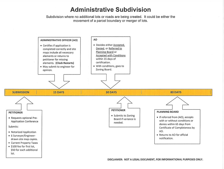
1. Administrative Subdivision.
Re-subdivision of existing lots which yields no additional lots for development, and involves no creation or extension of streets. Such re-subdivision shall only involve divisions, mergers, mergers and division, or adjustments of boundaries of existing lots.
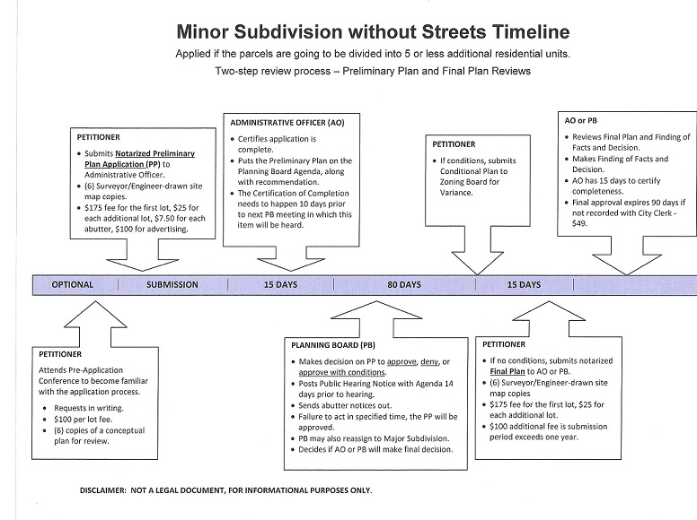
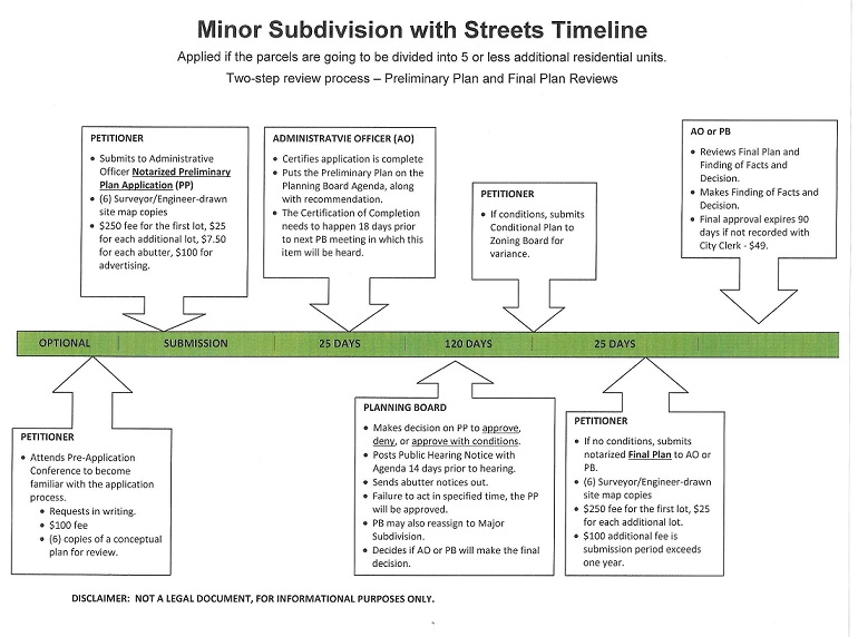
1. Minor subdivision or minor land development.
A residential subdivision of land or residential land development plan consisting of five (5) or fewer units or lots, provided that such subdivision or land development does not require waivers or modifications as specified in these regulations. All nonresidential subdivisions or land development plans shall be considered as major subdivisions or land development plans. Separation of multiple existing buildings on an existing lot shall be considered a minor subdivision if the resultant number of lots is greater than the number of lots in existence prior to subdivision. All developments of under six residential lots including the creation or extension of any street, or development of existing paper streets, shall be considered a minor subdivision regardless of whether a new lot is adjusted or created for development.
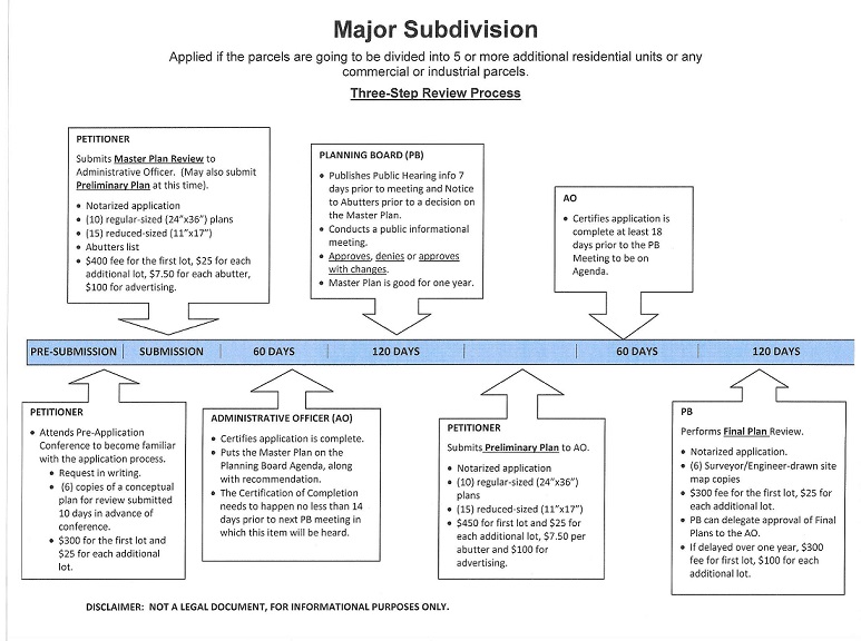
2. Major subdivision or major land development.
Any sub-division of land or land development plan not classified as either an administrative subdivision or a minor subdivision or minor land development plan.
2.2. Pre-application conference.
One or more pre-application conferences shall be held for all major land development or subdivision applications. Preapplication conferences may be held for administrative and minor applications, upon request of either the city or the applicant. Pre-application conferences shall allow the applicant to meet with appropriate local officials, boards, and/or commissions, planning staff, and, where appropriate, state agencies, for advice as to the required steps in the approvals process, the pertinent local plans, ordinances, regulations, rules and procedures and standards which may bear upon the proposed development project.
2.2.1. Concept review.
At the pre-application stage the applicant may request the planning board for an informal concept plan review for a development. The purpose of the concept plan review is also to provide planning board input in the formative stages of major subdivision and land development concept design.
3.2.2. Submission requirements.
Applicants seeking a pre-application conference or an informal concept review shall submit the following materials:
3.2.2.3. Meeting request.
Applicants shall submit a letter requesting a pre-application conference, which shall have been signed by the applicant(s) and property owner(s), and which shall contain a general description of the proposed subdivision or land development plan.
3.2.2.4. Concept plan.
Applicants shall submit two (2) full and fifteen (15) 11 x 17 inch legible prints and an electronic version of a concept plan to the administrative officer at least ten (10) days in advance of the conference(s). The concept plan need not be stamped by a registered land surveyor or registered professional engineer, but should be reasonably accurate with regard to location and area of existing and proposed features. Said plan shall encompass the entire tract of land proposed for subdivision, and shall include the following:
1. Name of the proposed subdivision;
2. Name(s) and address(es) of the applicant(s) and property owner(s);
3. Assessor’s plat and lot number for each parcel of land involved in the proposed subdivision;
3. Zoning district classification(s) of all land involved in the proposed subdivision;
4. Date of preparation of the plan, and the dates of all revisions to the plan;
5. Scale of the drawing, which shall be no smaller than one inch equals eighty feet (1” = 80’);
6. North arrow;
7. Locations and configurations of existing and proposed streets, alleys, railroads, lots and easements;
8. Area and street frontage of each proposed lot;
9. Location of all existing structures;
10. Approximate topographic conditions;
11. Location and area of all known water-bodies and wetlands;
12. Location and extent of existing mature vegetation and distinctive natural features;
13. Direction of drainage flow, location and capacity of existing and proposed drainage facilities;
14. Location of all existing and proposed utilities;
15. Designation of any land proposed for public dedication; and
16. Location map showing the physical relationship of the tract proposed for subdivision to areas within a one-half (1/2) mile radius of the perimeter of said tract.
3.2.5. Pre-application discussions.
Pre-application conferences shall aim to encourage information sharing and discussion of project concepts among the participants. Pre-application discussions are intended for the guidance of the applicant and shall not be considered approval of a project or its elements.
3.2 Submission of application.
An application for an administrative subdivision shall be submitted to the administrative officer in accordance with the requirements of section 4 herein. An application for a minor subdivision or a minor land development shall be submitted to the administrative officer in accordance with the requirements of section 5 herein. An application for a major subdivision or a major land development shall be submitted to the administrative officer in accordance with the requirements of section 6 herein. All property owners must sign a notarized statement on the appropriate application showing that they own clear title to the property claimed to be theirs on the subdivision/land development plan. In addition, if someone other than the owner of the land being subdivided submits an application, the applicant shall submit a notarized written statement from the owner authorizing such application.
3.3.1. Certification of complete application.
An application shall be complete for the purpose of commencing the applicable time period for action when so certified by the administrative officer. Every certification of completeness required by these regulations shall be in writing in a form to be approved by the planning board. In the event such certification of the application is not made within the time specified herein for the type of plan, the application shall be deemed complete for purposes of commencing the review period unless the application lacks information required for such applications as specified herein and the administrative officer has notified the applicant, in writing, of the deficiencies in the application. Upon their review, the Planning Board may subsequently require correction of any information found to be in error and submission of additional information specified in the regulations but not required by the administrative officer prior to certification, as is necessary to make an informed decision. When certificate of incompleteness is issued, the running of the time period set forth in this section will be deemed stopped upon the issuance of a certificate of incompleteness of the application by the administrative officer and will recommence upon the resubmission of a corrected application by the applicant. However, in no event will the administrative officer be required to certify a corrected submission as complete or incomplete in less than fourteen (14) days after its submission. For the purposes of calculating mandatory review periods as provided in these regulations, all days shall be considered to be calendar days. The certification of a complete application must be granted at least 10 days prior to a regularly scheduled Planning Board meeting for consideration to appear on the agenda. Due to notification requirements, when the planning board’s consideration requires a public informational meeting, the certification of a complete application must be granted at least fourteen (14) days prior to a regularly scheduled Planning Board meeting in order for the application to appear on the agenda. When the Planning Board’s consideration requires a public hearing, the certification of a complete application must be granted at least eighteen (18) days prior to a regularly scheduled Planning Board meeting in order for the application to appear on the agenda.
3.3.1.2 Administrative subdivision.
An application for administrative subdivision shall be certified as complete or incomplete by the administrative officer within a fifteen (15) day period from the date of its submission. Receipt of such submission shall be recorded as to time and date in an appropriate manner.
3.3.1.3. Minor subdivision or minor land development.
An application for minor subdivision or minor land development shall be certified as complete or incomplete by the administrative officer within a fifteen (15) day period from the date of its submission, or within a twenty-five (25) day period if a street creation or extension is required. These timeframes apply to both preliminary and final plans. Receipt of such submission shall be recorded as to time and date in an appropriate manner.
3.3.1.4. Major subdivision or major land development.
An application for major subdivision or major land development shall be certified as complete or incomplete by the administrative officer within a twenty-five (25) day period from the date of its submission for a Master Plan submission, within a twenty-five (25) day period from the date of its submission for a Preliminary Plan submission, and within a twenty-five (25) day period from the date of submission for a Final Plan submission, however, the time period for certification of completeness of a Final Plan may be extended to forty-five (45) days by written notice from the administrative officer to the applicant where the final plans contain changes to or elements not included in the preliminary plan approval. Receipt of such submission shall be recorded as to time and date in an appropriate manner.
3.3.5. Information required by planning board.
Notwithstanding sub-sections 3.1 and 3.3.1 above, the planning board may subsequently require correction of any information found to be in error and submission of additional information specified in the regulations but not required by the administrative officer prior to certification, as is necessary to make an informed decision.
3.3.6. Stay of review period.
Where the review is postponed with the consent of the applicant, pending further information or revision of information, the time period for review shall be stayed and shall resume when the planning board determines that the required application information is complete.
3.3 Project review stages.
Proposed subdivisions and land developments shall be reviewed and approved or disapproved in stages, as specified below.
3.4.1. Administrative Subdivision.
Administrative subdivision review shall consist of a single stage of review.
3.4.2. Minor subdivision and minor land development.
Minor subdivision and minor land development plan review shall consist of two stages of review -- preliminary plan review and final plan review -- provided that if a street creation or extension is involved, a public hearing is required. The planning board may combine the approval stages, following a determination by that board that all requirements for both stages have been met by the applicant.
3.4.3. Major subdivision and major land development.
Major subdivision and major land development plan review shall consist of three stages of review -- master plan, preliminary plan review and final plan review -- following the pre-application conference(s) specified in subsection 3.2.Also required is a public informational meeting and a public hearing. The planning board may vote to combine review stages and to modify and/or waive requirements as specified in subsection 2.4. The planning board may combine the approval stages, following a determination by that board that all necessary requirements have been met by the applicant.
3.4.4. Combination of review stages.
Whenever any stage in the application process shall be waived by the planning board and the applicant moved to a succeeding stage, seventy-five percent (75%) of the fees otherwise due for those stages must be paid by the applicant before advancement to the approved next step may be granted.
3.5. Phasing of projects.
The city may provide for the preliminary and final review stages, and for the construction of major land developments and subdivisions, to be divided into reasonable phases. When development phasing is permitted, the following shall be required:
1. Approval of the entire site design first as a master plan. Thereafter the development plans may be submitted for preliminary and/or final review and/or approval by phase(s).
2. General standards and regulations for determining physical limits of phases, completion schedules, and guarantees, for allowing progression to additional phases, for allowing two (2) or more phases to proceed in review or construction simultaneously, for interim public improvements or construction conditions, for changes to master or preliminary plans and may include other provisions as necessitated by local conditions.
3. The master plan documents may contain information on the physical limits of the phases, the schedule and sequence of public improvement installation, improvement guarantees, and the work and completion schedules for approvals and construction of the phases.
4. The master plan shall remain vested as long as it can be proved, to the satisfaction of the planning board, that work is proceeding on either the approval stages or on the construction of the development as shown in the approved master plan documents. Vesting shall extend to all information shown on the approved master plan documents.
3.6. Application review fees.
Each application for subdivision or land development approval must be accompanied by the appropriate application fee as set forth below.
3.6.1. Administrative subdivision review.
An applicant requesting the review of an administrative subdivision shall pay a fee equal to two hundred dollars ($200.00) for the first lot, plus fifty dollars $50 per lot thereafter involved in the proposed subdivision.
3.6.2. Minor subdivision and minor land development review.
An applicant requesting the review of a minor subdivision or minor land development shall pay fees according to the terms set forth below.
3.6.2.1. Pre-application review.
An applicant for a preliminary review of a minor subdivision shall pay a fee equal to two hundred dollars ($200.00) for such pre-application.
3.6.2.2. Preliminary plan review.
An applicant requesting the review of a preliminary plan for a minor subdivision or minor land development which does not involve the extension or creation of any street shall pay a fee equal to two hundred fifty dollars ($250.00) for the first lot and twenty-five dollars ($25.00) per lot for each additional lot to be created or redefined by the proposed subdivision or land development. An applicant requesting the review of a preliminary plan for a minor subdivision or minor land development which does involve the extension or creation of one or more streets shall pay a fee equal to the sum of three hundred fifty dollars ($350.00) for the first lot and twenty-five dollars ($25.00) per lot for each additional lot to be created or redefined by the proposed subdivision or land development, plus seven dollars and fifty cents ($7.50) per abutting property located within two hundred feet of the perimeter of the subject property; and the cost of advertising at the actual expense rate incurred by the City.
3.6.2.3. Final plan review.
An applicant requesting the review of a final plan for a minor subdivision or minor land development which does not involve the extension or creation of any street shall pay a fee equal to two hundred and fifty dollars ($250.00) for the first lot and twenty-five dollars ($25.00) per lot for each additional lot to be created or redefined by the proposed subdivision or land development. An applicant requesting the review of a final plan for a minor subdivision or minor land development which does involve the extension or creation of one or more streets shall pay a fee equal to the sum of three hundred dollars and no cents dollars ($300.00) for the first lot and twenty-five dollars ($25.00) per lot for each lot to be created or redefined by the proposed subdivision or land development.
3.6.2.2.1. Increased fees.
Whenever final plans are submitted more than twelve (12) months after preliminary plan approval, following the granting of an extension by the planning board, the fee for final plan review shall be increased to seventy-five dollars ($75.00) per lot for the review of plans which do not involve the extension or creation of any street, and one hundred twenty-five dollars ($125.00) per lot for the review of plans which do involve the extension of creation of one or more streets.
3.6.3. Major subdivision and major land development review.
An applicant requesting the review of a major subdivision or major land development shall pay fees according to the terms set forth below.
3.6.3.1. Pre-Application.
An applicant requesting a pre-application review for a major subdivision or major land development shall pay a fee equal to three hundred dollars ($300.00) for the first lot and twenty-five dollars ($25.00) per each additional lot in the proposed subdivision.
3.6.3.2. Master plan review.
An applicant requesting the review of a master plan for a major subdivision or major land development shall pay a fee equal to four hundred dollars ($400.00) for the first lot and fifty dollars ($50.00) per lot for each additional lot to be created or redefined by the proposed subdivision or land development, plus seven dollars and fifty cents ($7.50) per abutting property located within two hundred feet of the perimeter of the subject property, and the cost of advertising at the rate actually incurred by the City.
3.6.3.3. Preliminary plan review.
An applicant requesting the review of a preliminary plan for a major subdivision or major land development shall pay a fee equal to the sum of four hundred fifty dollars ($450.00) for the first lot and twenty-five dollars ($25.00) per lot for each additional lot to be created or redefined by the proposed subdivision or land development, plus seven dollars and fifty cents ($7.50) per abutting property located within two hundred feet of the perimeter of the subject property, the cost of advertising at the rate advertising actually incurred by the City.
3.6.3.4. Final plan review.
An applicant requesting the review of a final plan for a major subdivision or major land development shall pay a fee equal to the sum of four hundred dollars ($400.00) for the first lot plus twenty-five dollars ($25.00) per lot for each additional lot to be created or redefined by the proposed subdivision or land development.
3.6.3.5.1. Increased fees.
Whenever final plans are submitted more than twelve (12) months after preliminary plan approval, following the granting of an extension by the planning board, the fee for final plan review shall be increased to four hundred dollars ($400.00) for the first lot and one hundred dollars ($100.00) and each additional lot.
4. ADMINISTRATIVE SUBDIVISION
4.1. Submittal requirements.
Any applicant requesting approval of a proposed administrative subdivision, as defined herein, shall submit a completed application form, signed by the applicant(s) and property owner(s) and notarized, and six (6) legible prints of an administrative subdivision plan to the administrative officer.
4.1.1. Administrative subdivision plan.
Said administrative subdivision plan shall encompass the entire tract of land proposed for subdivision, shall be prepared, stamped and signed by a registered land surveyor or by a registered professional engineer, as appropriate under the requirements established by the State of Rhode Island for a Class I survey, and shall include, at a minimum, the following:
1. Name of the proposed subdivision;
2. Name(s) and address(es) of the applicant(s) and property owner(s);
3. Name(s), address(es) and telephone number(s) of the land surveyor(s) and/or engineer(s);
4. Assessor’s map and lot number for each parcel of land involved in the proposed subdivision and for each abutting parcel of land;
5. Zoning district classification(s) of all land involved in the proposed subdivision, along with the applicable minimum building setbacks required for that zone;
6. Information on any decision on a variance, special permit, or appeal made by the Zoning Board applicable to the subdivision of the land or its development;
7. Date of preparation of the plan, and the dates of all revisions to the plan;
8. Scale of the drawing, which shall be no smaller than one inch equals eighty feet (1” = 80’);
9. North arrow, including source;
10. Locations and configurations of existing streets, alleys, railroads, utilities, and existing structures and improvements;
11. Locations and configurations of existing and proposed lots and easements;
12. Area and street frontage of each proposed lot; and
13. Location of all existing structures, including distance of existing structures from any existing and proposed property lines;
14. Existing and proposed use of all lots;
15. Metes and bounds description;
16. Legal documents describing all proposed easements and rights-of-way; and,
17. Certification by the tax collector that all property taxes are current.
4.2. Project review.
Within fifteen (15) days of certification of completeness, the administrative officer or the technical review committee shall review the application and approve, deny or refer it to the planning board with recommendations. The officer or committee shall report its actions to the planning board at its next regular meeting, to be made part of the record.
4.2.1 Denial.
Denial of an application by the administrative officer shall not be appealable and shall require the plan to be submitted as a minor subdivision application.
4.2.2. Referral to planning board.
If referred to the planning board, the board shall consider the application and the recommendations of the administrative officer and/or the technical review committee and shall either approve, approve with conditions, or deny the application within sixty-five (65) days of certification of completeness. Failure of the planning board to act within the period prescribed shall constitute approval of the administrative subdivision plan and a certification of the administrative officer as to the failure of the planning board or committee to act within the required time and the resulting approval shall be issued on request of the applicant.
4.2.3. No action taken.
If no action is taken by the administrative officer or the technical review committee within the fifteen (15) days, the application shall be placed on the agenda of the next regular planning board meeting.
4.3. Vesting.
Approval of an administrative subdivision shall expire ninety (90) days from the date of approval unless within such period a plat in conformity with such approval is submitted for signature and recording as specified in section 12 herein.
5. MINOR SUBDIVISION AND MINOR LAND DEVELOPMENT
5.1. Preliminary submittal requirements.
Any applicant requesting approval of a proposed minor subdivision or minor land development, as defined herein, shall submit a completed application form, signed by the applicant(s) and property owner(s) and notarized, and two (2) large sized and fifteen (15) 11 x 17 legible print inch prints and an electronic version of a preliminary plan to the administrative in advance of the planning board meeting(s) at which said application is to be considered if no street creation or extension is proposed, based upon a meetings and deadline schedule approved annually by the planning board upon the recommendation of the administrative officer.
5.1.1. Preliminary plan not involving the creation or extension of any street.
Said preliminary plan shall encompass the entire tract of land proposed for subdivision or land development, shall be prepared, stamped and signed by a registered land surveyor or by a registered professional engineer, as appropriate under the requirements established by the State of Rhode Island for a Class I survey, and shall include the following:
1. Name of the proposed subdivision or land development;
2. Name(s) and address(es) of the applicant(s) and property owner(s);
3. Name(s), address(es) and telephone number(s) of the land surveyor(s) and/or engineer(s);
4. Assessor’s map and lot number for each parcel of land involved in the proposed subdivision or land development and for each abutting parcel of land;
5. Zoning district classification(s) of all land involved in the proposed subdivision or land development, along with the applicable minimum building setbacks required for that zone;
6. Information on any decision on a variance, special permit, or appeal made by the Zoning Board applicable to the subdivision of the land or its development;
7. Date of preparation of the plan, and the dates of all revisions to the plan;
8. Scale of the drawing, which shall be no smaller than one inch equals forty feet (1” = 40’);
9. North arrow including source;
10. Locations and configurations of existing and proposed streets, alleys, railroads, lots and easements;
11. Area and street frontage of each proposed lot;
12. Location of all existing structures including distance of existing structures from any existing and proposed property lines;
13. Location of all existing and proposed utilities;
14. Existing and proposed use of all lots;
15. Designation of any land proposed for public dedication, and conditions of such dedication, if any;
16. Names and locations of adjacent streets, alleys, subdivisions, railroads, water-bodies, wetlands, public lands and utilities on immediately adjoining properties;
17. Location map showing the physical relationship of the tract proposed for subdivision or land development to areas within a one-half (1/2) mile radius of the perimeter of said tract.
5.1.2. Preliminary plan involving the creation or extension of one or more streets.
Said preliminary plan shall encompass the entire tract of land proposed for subdivision or land development, shall be prepared, stamped and signed by a registered land surveyor or by a registered professional engineer, as appropriate under the requirements established by the State of Rhode Island for a Class I survey, and shall include the following:
1. Name of the proposed subdivision or land development;
2. Name(s) and address(es) of the applicant(s) and property owner(s);
3. Name(s), address(es) and telephone number(s) of the land surveyor(s) and/or engineer(s);
4. Assessor’s map and lot number for each parcel of land involved in the proposed subdivision or land development and for each abutting parcel of land;
5. Zoning district classification(s) of all land involved in the proposed subdivision or land development along with the applicable minimum building setbacks required for that zone;
6. Information on any decision on a variance, special permit, or appeal made by the Zoning Board applicable to the subdivision of the land or its development;
7. Names and addresses of owners of all properties, agencies, or communities requiring notification as required by these regulations. See Section 7;
8. Date of preparation of the plan, and the dates of all revisions to the plan;
9. Scale of the drawing, which shall be no smaller than one inch equals forty feet (1” = 40’);
10. North arrow including source;
11. Locations and configurations of existing and proposed streets, alleys, railroads, lots and easements;
12. Area and street frontage of each proposed lot;
13. Location of all existing structures including distance of existing structures from any existing and proposed property lines;
14. Contours at a minimum of two (2) foot intervals to show plainly the slope of the land;
15. Location and area of all known water-bodies and wetlands;
16. Location and extent of existing mature vegetation and distinctive natural features;
17. Direction of drainage flow, location and capacity of existing and proposed drainage facilities;
18. Location of all existing and proposed utilities;
19. Designation of any land proposed for public dedication, and conditions of such dedication, if any;
20. Existing and proposed use of all lots;
21. Designation of any land proposed for public dedication, and conditions of such dedication, if any;
22. Names and locations of adjacent streets, alleys, subdivisions, railroads, water-bodies, public lands and utilities on immediately adjoining properties;
23. Preliminary street profiles showing existing ground surface and proposed street grades, including extensions for a reasonable distance beyond the limits of the proposed subdivision or land development plan;
24. Ground water elevations and statements of subsoil conditions;
25. Any cross sections and/or details as required by the division engineer; and
26. Location map showing the physical relationship of the tract proposed for subdivision or land development to areas within a one-half (1/2) mile radius of the perimeter of said tract.
5.2. Preliminary review.
If no street creation or extension is required, the planning board shall approve, deny, or approve with conditions, the preliminary plan within sixty-five (65) days of certification of completeness, or within such further time as is agreed to by the applicant and the board, according to the requirements of title 45, chapter 23, section 63 of the General Laws of Rhode Island. If a street extension or creation is required, the planning board shall hold a public hearing prior to approval according to the requirements of section 7 herein, and shall approve, deny, or approve with conditions, the preliminary plan within ninety-five (95) days of certification of completeness, or within such further time as is agreed to by the applicant and the board, according to the requirements of title 45, chapter 23, section 63 of the General Laws of Rhode Island.
5.2.1. Technical review committee.
The technical review committee, if established, will review the application and will comment and make recommendations to the planning board. The application will be referred to the planning board as a whole if there is no technical review committee.
When reviewed by a technical review committee:
1. If the land development or subdivision plan is approved by a majority of the committee members, the application is forwarded to the planning board with a recommendation for preliminary plan approval without further review.
2. If the plan is not approved by a majority vote of the committee members, the minor land development or subdivision application is referred to the planning board.
5.2.2. Failure to act.
Failure of the planning board to act within the period prescribed shall constitute approval of the preliminary plan and a certificate from the administrative officer as to the failure of the planning board to act within the required time period and the resulting approval shall be issued on the request of the applicant.
5.2.3. Re-assignment to major review.
The planning board may re-assign a proposed minor project to major review only when the planning board is unable to make the positive findings required in subsection 2.3 herein.
5.2.4 The approved preliminary plan shall be vested for a period of one (1) year and vesting may be extended for a longer period, for good cause shown, if requested in writing by the applicant, and approved by the Planning Board. The vesting for the preliminary plan approval shall include all general and specific conditions as shown on the approved preliminary plan drawings and supporting material.
5.3. Final submittal requirements.
Following approval of the preliminary plan for a proposed minor subdivision or minor land development, the applicant shall submit two (2) large sized (24 x 36) and fifteen (15) 11 x 17 inch legible prints and an electronic version of a final plan to the administrative officer.
5.3.1. Final plan not involving the creation or extension of any street.
Said final plan shall encompass the entire tract of land proposed for subdivision or land development, shall be prepared, stamped and signed by a registered land surveyor or by a registered professional engineer, as appropriate under the requirements established by the State of Rhode Island for a Class I survey, and shall include the following:
1. Name of the proposed subdivision or land development;
2. Name(s) and address(es) of the applicant(s) and property owner(s);
3. Name(s), address(es) and telephone number(s) of the land surveyor(s) and/or engineer(s);
4. Assessor’s map and lot number for each parcel of land involved in the proposed subdivision or land development and for each abutting parcel of land;
5. Zoning district classification(s) of all land involved in the proposed subdivision or land development along with the applicable minimum building setbacks required for that zone;
6. Information on any decision on a variance, special permit, or appeal made by the Zoning Board applicable to the subdivision of the land or its development;
7. Date of preparation of the plan, and the dates of all revisions to the plan;
8. Scale of the drawing, which shall be no smaller than one inch equals forty feet (1” = 40’);
9. North arrow including source;
10. Locations and configurations of existing and proposed streets, alleys, railroads, lots and easements;
11. Area and street frontage of each proposed lot;
12. Location of all existing structures, including distance of existing structures from any existing and proposed property lines;
13. Location of all existing and proposed utilities;
14. Existing and proposed use of all lots;
15. Designation of any land proposed for public dedication, and conditions of such dedication, if any;
16. Names and locations of adjacent streets, alleys, subdivisions, railroads, water-bodies, wetlands, public lands and utilities on immediately adjoining pro-perties;
17. Location map showing the physical relationship of the tract proposed for subdivision or land development to areas within a one-half (1/2) mile radius of the perimeter of said tract.
18. Metes and bounds description;
19. Legal documents describing any proposed easements and rights-of-way; and,
20. Certification by the tax collector that all property taxes are current.
5.3.2. Final plan involving the creation or extension of one or more streets.
Said final plan shall encompass the entire tract of land proposed for subdivision or land development, shall be prepared, stamped and signed by a registered land surveyor or by a registered professional engineer, as appropriate under the requirements established by the State of Rhode Island for a Class I survey, and shall include the following:
1. Name of the proposed subdivision or land development;
2. Name(s) and address(es) of the applicant(s) and property owner(s);
3. Name(s), address(es) and telephone number(s) of the land surveyor(s) and/or engineer(s);
4. Assessor’s map and lot number for each parcel of land involved in the proposed subdivision or land development;
5. Zoning district classification(s) of all land involved in the proposed subdivision or land development along with the applicable minimum building setbacks required for that zone;
6. Information on any decision on a variance, special permit, or appeal made by the Zoning Board applicable to the subdivision of the land or its development;
7. Date of preparation of the plan, and the dates of all revisions to the plan;
8. Scale of the drawing, which shall be no smaller than one inch equals forty feet (1” = 40’);
9. North arrow including source;
10. Locations and configurations of existing and proposed streets, alleys, railroads, lots and easements;
11. Area and street frontage of each proposed lot;
12. Location of all existing structures including distance of existing structures from any existing and proposed property lines;
13. Contours at a minimum of two (2) foot intervals to show plainly the slope of the land;
14. Location and area of all known water-bodies and wetlands;
15. Location and extent of existing mature vegetation and distinctive natural features;
16. Direction of drainage flow, location and capacity of existing and proposed drainage facilities;
17. Location of all existing and proposed utilities;
18. Existing and proposed use of all lots;
19. Designation of any land proposed for public dedication, and conditions of such dedication, if any;
20. Designation of any land proposed for public dedication, and conditions of such dedication, if any;
21. Names and locations of adjacent streets, alleys, subdivisions, railroads, water-bodies, public lands and utilities on immediately adjoining properties;
22. Street profiles showing existing ground surface at center line, left gutter line and right gutter line, and proposed street grades labeled at datum lines, every fifty (50) foot section, and all components of vertical curves, including extensions for a reasonable distance beyond the limits of the proposed subdivision or land development plan;
23. Ground water elevations and statements of subsoil conditions;
24. Any cross sections and/or details as required by the division engineer; and
25. Location map showing the physical relationship of the tract proposed for subdivision or land development to areas within a one-half (1/2) mile radius of the perimeter of said tract.
27. All permits required by state or federal agencies prior to commencement of construction, including delineation verifications and/or permits related to freshwater wetlands, floodplains, preliminary suitability for individual septic disposal systems, public water systems, and connections to state roads;
28. Metes and bounds descriptions;
29. Legal documents describing any proposed easements and rights-of-way;
30. Arrangements for completion of the required public improvements, including construction schedules and/or improvement guarantees as required in section 11 of these regulations; and,
31. Certification by the tax collector that all property taxes are current.
5.4. Final review.
The planning board may delegate final plan review and approval to the administrative officer or the technical review committee. The officer or committee shall report its actions to the planning board at its next regular meeting, to be made part of the record.
5.5. Vesting.
Final approval of a minor subdivision or minor land development plan shall expire ninety (90) days from the date of approval unless within such period a final plat, in conformity with such approval, and as defined herein, is submitted for signature and recording as specified in section 12. Validity may be extended for a longer period, for cause shown, if requested by the applicant in writing, and approved by the planning board.
6. MAJOR SUBDIVISION AND MAJOR LAND DEVELOPMENT
6.1. Master plan submittal requirements.
Any applicant requesting approval of a proposed major subdivision or major land development, as defined herein, shall submit a completed application form, signed by the applicant(s) and property owner(s) and notarized, along with two (2) regular-sized (24x36) and fifteen (15) reduced-sized (11x17) legible prints and an electronic version of the master plan for the proposed subdivision or land development and initial comments on the proposed subdivision or land development, to the administrative officer at least fourteen (14) days in advance of the planning board meeting(s) at which said application is to be considered.
6.1.1. Master plan.
Said master plan shall encompass the entire tract of land proposed for subdivision or land development, and shall include but not be limited to the following:
1. Information on the natural and built features of the surrounding neighborhood;
2. Existing natural and man-made conditions of the development site, including topographic features;
3. Freshwater wetland boundaries;
4. Floodplains;
5. Proposed design concept;
6. Proposed public improvements and dedications;
7. Tentative construction phasing;
8. Potential neighborhood impacts; and
9. Name and address of all property owners within 200-feet of the perimeter of the entire property under consideration for subdivision or land development
6.1.2 Initial comments.
Initial comments shall be solicited from the parties listed below.
The administrative officer shall coordinate review and comment by local officials, adjacent communities, and state and federal agencies.
1. Local agencies including, but not limited to, the planning department, the department of public works, the police and fire departments, the conservation commission, and the parks and recreation commission;
2. Adjacent communities;
3. State agencies, as appropriate, including the department of environmental management, the department of transportation, and the coastal resource management council; and
4. The administrative officer shall coordinate review and comments by local officials, adjacent communities, state, and federal agencies. National agencies, as appropriate.
5. Certification. The application must be certified, in writing, complete or incomplete by the administrative officer within twenty-five (25) days , according to the provisions of § 45-23-36(b). The running of the time period set forth herein will be deemed stopped upon the issuance of a certificate of incompleteness of the application by the administrative officer and recommence upon the resubmission of a corrected application by the applicant. However, in no event will the administrative officer be required to certify a corrected submission as complete or incomplete less than fourteen (14) days after its submission.
6.1.3. Technical review committee.
The technical review committee, if established, shall review the application and shall comment and make recommendations to the planning board.
6.2 Master plan review.
The administrative officer shall review the materials submitted by the applicant for master plan approval, and shall certify such submission complete or incomplete within twenty-five (25) days, according to the provisions of section 3 herein, provided, however, that in no event will the administrative officer be required to certify a corrected submission as complete or incomplete less than fourteen (14) days after its submission.
5.2.1. Informational meeting.
A public informational meeting shall be held prior to the planning board decision on the master plan, unless the master plan and preliminary plan approvals are being combined, in which case the public informational meeting shall be optional, based upon planning board determination.
6.2.2. Public notice requirements.
Public notice for the public informational meeting is required and shall be given at least seven (7) days prior to the date of the meeting in a newspaper of general circulation within the city. Postcard notice shall be mailed at least seven (7) days prior to the date of the meeting to the applicant and to all property owners within the notice area specified in subsection 7.2.2.1 herein.
6.2.1.2. Presentation and comment procedure.
At the public informational meeting, the applicant shall present the proposed development project. The planning board shall allow oral and written comments from the general public. All public comments shall be made part of the public record of the project application.
6.2.2 Decision.
The planning board shall, within one hundred and twenty (120) ninety (90) days of certification of completeness, or within such further time as may be consented to by the applicant through the submission of a written waiver, approve of the master plan as submitted, approve with changes and/or conditions, or deny the application, according to the requirements of title 45, chapter 23, section 60 and 63 of the General Laws of Rhode Island.
6.22.1 Failure to act.
Failure of the planning board to act within the period prescribed shall constitute approval of the master plan and a certificate from the administrative officer as to the failure of the planning board to act within the required time and the resulting approval shall be issued on request of the applicant.
6.2.3. Vesting. The approved master plan shall be vested for a period of one (1) two (2) years, with a one two (2) (1) year extension upon written request by the applicant, who must appear before the planning board for the annual review. Vesting may be extended for a longer period, for good cause shown, if requested in writing by the applicant, and approved by the planning board. Master plan vesting shall include the zoning requirements, conceptual layout and all conditions shown on the approved master plan drawings and supporting materials. The initial four-year (4) vesting for the approved master plan constitutes the vested rights for the development as required in § 45-24-44.
6.3. Preliminary submittal requirements.
Following approval of the master plan for a proposed major subdivision or major land development, and within the vesting period for said master plan, the applicant shall submit two (2) regular-sized (24x36) and fifteen (15) reduced-sized (11x17) legible prints and an electronic version of a preliminary plan to the administrative officer at least eighteen (18) days in advance of the planning board meeting(s) at which said preliminary plan is to be considered.
6.3.1. Preliminary plan.
Said preliminary plan shall encompass the entire tract of land proposed for subdivision or land development, shall be prepared, stamped and signed by a registered land surveyor or by a registered professional engineer, as appropriate under the requirements established by the State of Rhode Island for a Class I survey, and shall include but not be limited to the following:
1. Name of the proposed subdivision or land development;
2. Name(s) and address(es) of the applicant(s) and property owner(s);
3. Name(s), address(es) and telephone number(s) of the land surveyor(s) and/or engineer(s);
4. Assessor’s map and lot number for each parcel of land involved in the proposed subdivision or land development;
5. Names and addresses of owners of all properties, agencies, or communities requiring notification as required by these regulations. See section 7;
6. Zoning district classification(s) of all land involved in the proposed subdivision or land development along with the applicable minimum building setbacks required for that zone;
7. Information on any decision on a variance, special permit, or appeal made by the Zoning Board applicable to the subdivision of the land or its development;
8. Date of preparation of the plan, and the dates of all revisions to the plan;
9. Scale of the drawing, which shall be no smaller than one inch equals forty feet (1” = 40’);
10. North arrow, including source;
11. Locations and configurations of existing and proposed streets, alleys, railroads, lots and easements;
12. Area and street frontage of each proposed lot;
13. Location of all existing structures including distance of existing structures from any existing and proposed property lines;
14. Contours at a minimum of two (2) foot intervals to show plainly the slope of the land;
15. Location and area of all known water-bodies and wetlands;
16. Location and extent of existing mature vegetation and distinctive natural features;
17. Direction of drainage flow, location and capacity of existing and proposed drainage facilities;
18. Location of all existing and proposed utilities;
19. Existing and proposed use of all lots;
20. Designation of any land proposed for public dedication, and conditions of such dedication, if any;
21. Names and locations of adjacent streets, alleys, subdivisions, railroads, water-bodies, public lands and utilities on immediately adjoining properties;
22. Preliminary street profiles showing existing ground surface and proposed street grades, including extensions for a reasonable distance beyond the limits of the proposed subdivision or land development plan;
23. Ground water elevations and statements of subsoil conditions;
24. Any cross sections and/or details as required by the division engineer;
25. Location map showing the physical relationship of the tract proposed for subdivision or land development to areas within a one-half (1/2) mile radius of the perimeter of said tract;
26. All permits required by state or federal agencies prior to commencement of construction, including permits related to freshwater wetlands, floodplains, preliminary suitability for individual septic disposal systems, public water systems, and connections to state roads;
27. Final written comments and/or approvals of the department of public works, the police department, the fire department, the division engineer, the city solicitor, other local government departments, commissions, or authorities as appropriate; and
28. Copies of all legal documents describing the property, proposed easements, and rights-of-way.
Certification: The application will be certified as complete or incomplete by the administrative officer within sixty (60) twenty-five (25) days, according to the provisions of § 23-36(b). The running of the time period set forth herein will be stopped upon the issuance of a certificate of incompleteness by the administrative officer and will recommence upon the resubmission of a corrected application by the applicant. However, in no event shall the administrative officer be required to certify a corrected submission as complete or incomplete less than ten (10) days after its submission.
6.4. Preliminary review.
The administrative officer shall review the materials submitted by the applicant for preliminary plan approval, and shall certify such submission complete or incomplete within twenty-five (25) days, according to the provisions of section 3 herein.
6.4.1. Technical review committee.
The technical review committee, if established, shall review the application and shall comment and make recommendations to the planning board.
6.4.2. Public improvement guarantees.
Proposed arrangements for completion of the required public improvements, including construction schedule and/or financial guarantees shall be reviewed and approved by the planning board at preliminary plan approval.
6.4.3. Public hearing.
Prior to planning board decision on the preliminary plan, a public hearing, which adheres to the requirements for notice described in section 7, must be held.
6.4.4. Decision.
A complete application for a major subdivision or land development plan shall be approved, approved with conditions or denied within one hundred and twenty (120) ninety (90) days of the date when it is certified complete, or within such further time as may be consented to be the developer through the submission of a written waiver.
4.3.1. Failure to act.
Failure of the planning board to act within the period prescribed shall constitute approval of the preliminary plan and a certificate from the administrative officer as to the failure of the planning board to act within the required time and the resulting approval shall be issued on the request of the applicant.
6.4.5. Vesting.
The approved preliminary plan shall be vested for a period of two (2) years with the right to extend for two (2) one-year extensions and vesting may be extended for a longer period, for good cause shown, if requested in writing by the applicant, who must appear before the planning board for each annul review and provide proof of valid state or federal permits as applicable and approved by the planning board. Thereafter, vesting may be extended for a longer period, for good cause shown, if requested, in writing by the applicant, and approved by the planning board. The vesting for the preliminary plan approval shall include all general and specific conditions as shown on the approved preliminary plan drawings and supporting material.
6.5. Final submittal requirements.
Following approval of the preliminary plan for a proposed major subdivision or major land development, and within the vesting period for said preliminary plan, the applicant shall submit two (2) legible prints (24 x 36 inches, fifteen reduced copies 911 x 17 “) and an electronic version of a final plan to the administrative officer.
6.5.1. Final plan. Said final plan shall encompass the entire tract of land proposed for subdivision or land development, shall be prepared, stamped and signed by a registered land surveyor or by a registered professional engineer, as appropriate under the requirements established by the State of Rhode Island for a Class I survey, and shall include but not be limited to the following:
1. Name of the proposed subdivision or land development;
2. Name(s) and address(es) of the applicant(s) and property owner(s);
3. Name(s), address(es) and telephone number(s) of the land surveyor(s) and/or engineer(s);
4. Assessor’s map and lot number for each parcel of land involved in the proposed subdivision or land development;
5. Zoning district classification(s) of all land involved in the proposed subdivision or land development, along with the applicable minimum building setbacks required for that zone;
6. Information on any decision on a variance, special permit, or appeal made by the Zoning Board applicable to the subdivision of the land or its development;
7. Date of preparation of the plan, and the dates of all revisions to the plan;
8. Scale of the drawing, which shall be no smaller than one inch equals forty feet (1” = 40’);
9. North arrow, including source;
10. Locations and configurations of existing and proposed streets, alleys, railroads, lots and easements;
11. Area and street frontage of each proposed lot;
12. Location of all existing structures including distance of existing structures from any existing and proposed property lines;
13. Contours at a minimum of two (2) foot intervals to show plainly the slope of the land;
14. Location and area of all known water-bodies and wetlands;
15. Location and extent of existing mature vegetation and distinctive natural features;
16. Direction of drainage flow, location and capacity of existing and proposed drainage facilities;
17. Location of all existing and proposed utilities;
18. Existing and proposed use of all lots;
19. Designation of any land proposed for public dedication, and conditions of such dedication, if any;
20. Names and locations of adjacent streets, alleys, subdivisions, railroads, water-bodies, public lands and utilities on immediately adjoining properties;
21. Street profiles showing existing ground surface at center line, left gutter line and right gutter line, and proposed street grades labeled at datum lines, every fifty (50) foot section, and all components of vertical curves, including extensions for a reasonable distance beyond the limits of the proposed subdivision or land development plan;
22. Ground water elevations and statements of subsoil conditions;
23. Any cross sections and/or details as required by the division engineer;
24. Location map showing the physical relationship of the tract proposed for subdivision to areas within a one-half (1/2) mile radius of the perimeter of said tract;
25. All permits required by state or federal agencies prior to commencement of construction, including permits related to freshwater wetlands, floodplains, preliminary suitability for individual septic disposal systems, public water systems, and connections to state roads;
26. Final written comments and/or approvals of the department of public works, the police department, the fire department, the division engineer, the city solicitor, other local government departments, commissions, or authorities as appropriate;
27. Metes and bounds descriptions;
28. All legal documents describing the property, proposed easements and rights-of-way;
29. All supporting material required by the planning board when the application was granted preliminary plan approval;
30. Arrangements for completion of the required public improvements, including construction schedule and/or financial guarantees;
31. Certification by the tax collector that all property taxes are current; and
32. For phased projects, the final plan for phases following the first phase shall be accompanied by copies of as-built drawings not previously submitted of all existing public improvements for prior phases.
6.6. Final review.
The administrative officer shall review the materials submitted by the applicant for final plan approval, and shall certify such submission complete or incomplete within twenty-five (25) days, according to the provisions of section 3 herein. This time period may be extended to forty-five (45) days by written notice from the administrative officer to the applicant where the final plans contain changes to or elements not included in the preliminary plan approval.
6.6.1. Approval.
If the administrative officer certifies the application as complete and does not require submission to the planning board as per subsection 6.6.2 below, the final plan shall be considered approved.
6.6.2. Referral to the planning board.
If the administrative officer determines that an application for final approval does not meet the requirements set by these regulations or by the planning board at the preliminary approval, the administrative officer shall refer the final plan to the planning board for review. The planning board shall, within forty-five (45) days after the certification of completeness, or within such further time as may be consented to by the applicant, approve or deny the final plan as submitted.
6.6.2.1. Failure to act.
Failure of the planning board to act within the period prescribed shall constitute approval of the final plan and a certificate from the administrative officer as to the failure of the planning board to act within the required time and the resulting approval shall be issued on request of the applicant.
6.6.3. Recording.
The final approval of a major subdivision or land development project shall expire one (1) year from the date of approval unless, within that period, the final plat shall have been submitted for signature and recording as specified in section 12 of these regulations. The planning board may, for good cause shown, extend the period for recording for an additional period.
6.6.4. Acceptance of public improve-ments.
Signature and recording as specified in section 12 of these regulations shall constitute acceptance by the city of any street or other public improvement or other land intended for dedication. Final plan approval shall not impose any duty upon the city to maintain or improve those dedicated areas until the city council accepts the completed public improvements as constructed in compliance with the final plans.
6.6.5. Validity of recorded plans.
The approved final plan, once recorded, shall remain valid as the approved plan for the site unless and until an amendment to the plat is approved under the procedures set forth in section 12.5 of these regulations, or a new plan is approved by the planning board.
7. PUBLIC HEARING PROCESS
7.1. Public hearing required.
A public hearing shall be required for any major subdivision or major land development project, as well as for any minor subdivision or minor land development involving the creation or extension of any street.
7.2 Notice requirements.
Public notice of the hearing shall be given as follows:
7.2.1. Newspaper notice.
Public notice of the hearing shall be given at least fourteen (14) days prior to the date of the hearing in a newspaper of general circulation within the city following the city’s usual and customary practices for such advertising.
7.2.2 Notice to applicant and property owners.
Notice shall be sent to the applicant and to each owner of real property within the notice area specified in section 7.2.2.1 below, by certified mail, return receipt requested, of the time and place of the hearing not less than ten (10) days prior to the date of the hearing. Said notice shall also include the street address of the subject property, or if no street address is available, the distance from the nearest existing intersection in tenths (1/10’s) of a mile.
6.2.2.1. 7.2.2.1. Notice area.
6.2.2.2.
The area for notice of the public hearing shall include all property within two hundred feet (200') of the perimeter of the entire property under consideration, including property that is separate from the
The subject property by any street, easement, right-of-way, or waterbody.
7.2.2.2. Notice within watersheds.
Additional notice within watersheds shall also be sent by first class mail to the city or town planning board of any municipality where there is a public or quasi-public water source, or private water source that is used or is suitable for use as a public water source, located within two thousand feet (2,000') of the boundaries of the city.
7.2.2.3 Notice to water departments or agencies.
Notice of the public hearing shall be sent to the governing body of any state or municipal water department or agency, special water district, or private water company that has riparian rights to a surface water resource and/or surface watershed that is used or is suitable for use as a public water source located within either the city or two thousand feet (2,000') of the boundaries of the city, provided, however, that a map survey has been filed with the building inspector as specific in title 45, chapter 24, section 53(E) of the General Laws of Rhode Island.
7.2.3 Notice to adjacent municipalities.
Notice of the public hearing shall be sent by the administrative officer to the administrative officer of an adjacent municipality if:
1. The notice area extends into the adjacent municipality;
2. The development site extends into the adjacent municipality; or
3. There is a potential for significant negative impact on the adjacent municipality.
7.3. Notice cost.
The cost of all such notice shall be borne by the applicant.
7.4. Procedures – Meetings – Votes – Decisions and records.
(a) All records of the planning board proceedings and decisions shall be written and kept permanently available for public review. Completed applications for proposed land development and subdivision projects under review by the planning board shall be available for public review.
(b) Participation in a planning board meeting or other proceedings by any party is not a cause for civil action or liability except for acts not in good faith, intentional misconduct, knowing violation of law, transactions where there is improper personal benefit, or malicious, wanton, or willful misconduct.
(c) All final written comments to the planning board from the administrative officer, municipal departments, the technical review committee, state and federal agencies, and local commissions are part of the permanent record of the development application.
(d) Votes: All votes of the planning board shall be made part of the permanent record and show the members present and their votes. A decision by the planning board to approve any land development or subdivision application requires a vote for approval by the majority of the current planning board membership.
(e) All written decisions of the planning board shall be recorded in the land evidence records of the City of Woonsocket within twenty (20) days after the planning board vote. A copy of the recorded decision shall be mailed within one business day of recording, by any method that provides confirmation of receipt, to the applicant and to any objector who has filed a written request for notice with the administrative officer.
8. PHYSICAL DESIGN REQUIREMENTS
8.1. General.
8.1.1. Suitability of the land.
The planning board shall not approve any application for subdivision or land development if it considers the land proposed for subdivision or development to be unsuitable for platting and building purposes due to the physical characteristics of the land, including its susceptibility to flood inundation.
8.1.2. Conformance with zoning ordinance.
All subdivisions and land development plans shall be in conformance with the requirements of the zoning ordinance, or any variances issued therein.
8.2. Streets.
8.2.1. Frontage and access on improved streets.
The area to be subdivided shall have frontage on, according to the requirements of the Zoning Ordinance, or any variances issued therein by the Zoning Board, and access to an existing, improved public street. If a street has not been improved to the standards and specifications of these regulations, the Board may require the applicant to make certain improvements along the part of the street abutting the property or leading to the property being subdivided where necessary for drainage, safety, traffic or other reasons as deemed proper by the Board.
8.2.2. Paper streets.
For the purposes of these regulations, streets that have been platted but not improved or accepted for maintenance by the City or State, shall not be considered existing improved public streets. Where these streets are incorporated within the subdivision, they shall be improved by the developer to meet the requirements of these regulations.
8.2.3. Relation to existing and planned streets.
All streets shall be considered in relation to existing and planned streets and shall be arranged to conform with any officially adopted plan of the city or any portion thereof. In general, and wherever possible, streets shall be planned in relation to topographical conditions.
8.2.4. Arrangement of streets.
Where the plans of the city do not indicate the size, location, direction and extent of a street, the arrangement of streets in a subdivision shall:
1. Provide for the continuation of the principal streets existing in the adjoining subdivision, or the proper projection of existing principal streets when adjoining property is not subdivided, in either case, the streets being of a width at least as great as that of such existing streets (refer to section 8.2.7 for minimum street rights-of-way), or
2. Conform to a plan for a neighborhood drawn up and adopted by the planning board to meet a particular situation where topographical conditions make continuance or conformance to existing streets impracticable.
8.2.5. Plan covering portion of tract.
Where the plan submitted covers only a part of the subdivider’s tract, a sketch of the prospective future street system of the part not submitted shall be furnished, and the street system of the part submitted shall be considered in the light of adjustments and connections with the street system of the part not submitted.
8.2.6. Planning for later subdivision.
Where the tract is subdivided into lots of an acre, or more, the planning board may require such an arrangement of its streets as will permit a later subdivision, in conformity with the street requirements specified herein, and in order that the later subdivision may conform to the ultimate location of streets and extension of adjacent streets as shown in the comprehensive plan.
8.2.7. Apportioning of street right-of-way.
The apportioning of the street between roadway, sidewalk areas, and grass strips shall be in accordance with standards as indicated on the drawing entitled “Standard Design for City Streets”, which is attached in Appendix A.
The minimum right-of-way width for streets shall be as shown on any plan of the city hereafter adopted, and when not indicated on such plan shall be sixty (60) feet for arterial streets, and forty-five (45) feet for both collector streets and local streets. These widths shall be measured from lot line to lot line.
8.2.8. Cul-de-sacs.
Dead-end streets not designed for eventual completion shall not be approved unless provide with a cul-de-sac. All cul-de-sacs shall have a minimum right-of-way radius of forty-seven (47) feet, and a minimum paved radius of forty (40) feet.
Such dead-end streets shall not be in excess of six hundred (600) feet in length. All cul-de-sacs shall be clearly indicated as dead-end streets at their entrance. Alternate designs for dead-end streets may be developed only with the approval of the Division Engineer and Planning Board. The Planning Board may allow for the construction of temporary cul-de-sacs and/or defeasible easements as part of a phased development or in planning for later subdivision.
8.2.9. Private streets prohibited. Private streets shall not be approved except as permitted under the planned residential development section of the zoning ordinance. In no case shall publicly-owned utilities be located in private streets without the written approval of the Director of Public Works.
8.2.10. Grade requirements. The maximum grade of arterial streets shall be five per cent (5%) and the maximum grade for collector and local streets shall not exceed ten per cent (10%), except that it may be increased where, in the opinion of the planning board, it is necessary to adjust to topographic conditions. The minimum grade of all streets shall be one per cent (1.5%).
8.2.11. Cut or fill.
Where the grading of any street right-of-way requires two or more feet of cut or fill, retaining walls shall be installed on private property, along abutting property lines or the abutting land shall be graded to a maximum slope of 3:1 at said property lines. Slope easements may be required at the discretion of the division engineer.
8.2.12. Intersection of streets.
Streets shall be laid out so as to intersect as nearly as possible at right angles. No street shall intersect with another street at an angle of less than sixty (60) degrees. Where a deflection angle of more than ten (10) degrees occurs along the center line of a street, a center line curve having a radius of not less than one hundred and seventy-five (175) feet shall be introduced.
8.2.13. Rounding of property lines.
Property lines at street intersections shall be rounded with radii of not less than twenty (20).
8.2.14. Minimum site distances.
Minimum site distances shall conform to all applicable provisions of the Manual of Traffic Engineering.
8.2.15. Street names.
No street name may be used which will duplicate or be substantially similar to the name of any existing street. Any extension of an existing street shall have the same name as the existing street.
8.2.16. Reserve strips.
There shall be no reservation of strips of land or installation of any physical barrier to control access to any street, except where the control of such strip or physical barrier is definitely placed with the city under conditions approved by the city council.
8.2.17. Layout of local streets.
Local streets shall be laid out so that their use by through traffic will be discouraged.
8.2.18. Center line offsets prohibited.
Cross streets shall have no center line offsets unless deemed necessary by the planning board in the case of a connection with an existing street.
The minimum distance between two (2) street intersections shall be one hundred and twenty-five (125) feet measured from center line to center line.
8.2.19. Limited access to arterial streets.
Where a subdivision abuts or contains an existing or proposed .arterial street as shown on an adopted plan or appropriate portion thereof, the planning board may limit access to said arterial street from abutting properties and require the provision of marginal access streets for the purpose of providing these properties with street access.
8.2.20. Pedestrian crosswalks.
Pedestrian crosswalks, not less than ten (10) feet wide, and associated wheelchair ramps may be required where deemed essential to provide pedestrian circulation or access to schools, playgrounds, shopping centers, transportation, and other community facilities.
8.3. Alleys and easements.
8.3.1. Alleys prohibited in residential subdivisions.
Alleys shall not be permitted in residential subdivisions except that alleys may be required where such properties abut major thoroughfares and where, in the opinion of the planning board, traffic hazards and congestion may make the provision of alleys desirable.
8.3.2. Alleys permitted in commercial and industrial subdivisions.
Alleys shall be provided in commercial and industrial districts, except that the planning board may waive this requirement where other definite and assured provision is made for service access, such as off-street loading, unloading and parking consistent with and adequate for the use proposed.
8.3.3. Alley width requirements.
The width of an alley shall not be less than twenty feet (20’).
8.3.4. Utility easements.
The planning board may require easements, the configuration of which shall be determined by the city engineer, for poles, wires, conduits, storm and sanitary sewers, sub-drainage facilities, gas, water and heat mains or other utility lines. If in the opinion of the planning board the most suitable and reasonable locations for sewers, storm drains, sub-drainage facilities, water and gas pipes, electric pole lines and conduits, or other utilities likely to be required do not lie wholly within the plat, the planning board, may require, insofar as reasonable, provision to be made for the location of such utilities outside the plat. Such requirements must be effectuated by the dedication of public easements as part of the plat or by the filing of supplementary instruments which will adequately protect the public interest in the proper location of said utilities.
8.4. Blocks.
8.4.1. Length requirements.
Blocks shall not exceed one thousand four hundred (1400) feet in length.
8.4.2. Width requirements.
Blocks shall be wide enough to allow two (2) tiers of lots of minimum depth as prescribed by the zoning ordinance. A single tier of lots may adjoin a major thoroughfare when access is provided these lots by marginal access or other street.
8.4.3. Industrial and commercial blocks.
Industrial and commercial blocks shall be platted in such a way as to be suited for the intended occupancy. The planning board shall require that industrial blocks be large enough to accommodate potential industries, and that commercial and industrial areas make adequate provision for future parking and delivery service.
8.5. Lots.
8.5.1. Width requirements.
The minimum lot width for all lots shall conform with the requirements of the zoning ordinance.
8.5.2. Depth requirements.
The mean depth of a lot shall be not less than one (1) and not more than three (3) times the mean width of the lot, except that
1. Where alleys are shown, the planning board may limit the depth of lots, for the purpose of preventing future alley lots or buildings or may require the establishment of building lines along the alley adequate for the conversion of such alley into a residential street.
8.5.3. Area requirements.
The minimum lot area for all lots shall conform with the requirements of the zoning ordinance, except that:
1. Lots served by a public water system but requiring individual sewage disposal systems (septic tanks) shall conform to all applicable ISDS regulations, and shall be larger than the minimum permissible size when, in the opinion of the planning board, percolation tests or topographic conditions indicate the need for such higher area requirements; and
2. Lots utilizing both individual water supply and individual sewage disposal systems shall conform to all applicable ISDS regulations, and shall be at least fifteen thousand (15,000) square feet in area, or larger if in the opinion of the planning board percolation tests indicate such higher area requirements.
8.5.4. Building setback requirements.
Building setback lines shall conform with the requirements of the zoning ordinance.
8.5.5. Configuration of lot lines.
So far as practicable, all lot side lines shall be at right angles to straight street lines or radial to curved street lines. An arrangement placing adjacent lots at right angles to one another shall be avoided wherever possible.
8.5.6. Use of lots.
The proposed use of lots must be designated.
8.6. Sidewalks.
Cement concrete sidewalks may be required where in the opinion of the planning board density of population or safety factors make them necessary. Where required, they shall be built to standards indicated in section 9 herein.
8.7. Drainage.
All plats shall provide for the adequate drainage from the plat area of all surface and subsurface waters. Pre- and post-development hydraulic analysis shall be submitted to the division engineer for review for all major subdivisions and land develop-ment projects. Pre- and post-development hydraulic analysis may be required for minor subdivisions and land development projects, as determined by the division engineer. There shall be no net increase in the rate of runoff above the predevelopment rate for the 100-year storm, unless approved by the division engineer. In those cases where there exists a significant manmade or natural downstream storm water storage, retention, or detention feature or other receiving body, the division engineer may require additional hydraulic studies to identify the impact of the proposed development on these downstream features and may require additional remediation action(s) as part of the proposed development. All subdivision and land development projects shall conform to the requirements of the City’s Post-Construction and Stormwater Management Ordinance.
8.7.1. Drainage facilities.
Any drainage facility shall conduct water to a location and in a manner approved by the division engineer.
8.7.2. Ground water elevation.
If the original ground water elevation is higher than seven (7) feet below the proposed finished street grade, then:
1. Sub-drainage facilities adequate to lower the ground water elevation to seven (7) feet below finish street grade; or
2. Restrictions shall be required on the final plat, providing for the location of the lowest floor elevation of a building at least three (3) feet above ground water elevation; or
3. Restrictions shall be required on the final plat providing for construction designed to help prevent ground water from entering the building.
8.7.3. Alteration of contours prohibited.
No original contours of a subdivision shall be altered so as to reduce the suitability of the soil for proper sub-drainage. Additional percolation tests may be required in areas where the contours have been altered.
8.7.4. Location of sewage disposal systems and water supplies.
Where an individual sewage disposal system and an individual water supply source are required on the same lot or adjoining lots, they shall be located so that the danger of contamination of the water supply is minimized.
8.7.5. Extension of available public services.
Any subdivision having either public water or public sewer systems or both available or to be made available for extension within three hundred (300) feet of its boundary, shall have such available systems extended to provide service to each lot in the subdivision before the plat shall be eligible for final approval.
8.8. Landscaping.
8.8.1. Street trees.
Trees shall be planted or left standing on each side of the street in the required front yard area having a maximum space of fifty (50) feet between trees as measured on the street property line. Distances between trees and street property line may vary. If planted, trees shall be planted in accordance with the provisions of section 9 herein.
8.9. Public open space.
8.9.1. Dedication or reservation of open space.
Where a park, neighborhood open recreation space, school site, drainage area, or other public use, which is located in whole or in part in the applicant’s subdivision, is shown on any plan of the city, or appropriate section thereof, hereafter adopted, the city council, may where it is reasonable to do so, require the dedication or reservation of such open space within the subdivision. In all subdivisions, due regard must be shown for all natural features, such as large trees, natural groves, watercourses, scenic points, historic spots and similar community assets which if preserved, will add attractiveness and value to the property. The dedication to the city of planting and barrier strips and the preservation of the drainage and natural stream channels must be considered by the subdivider wherever feasible.
9. PUBLIC IMPROVEMENT STANDARDS
9.1. Bounds.
9.1.1. Type and size of bounds.
All bounds shall be of granite approximately six (6) inches by six (6) inches in cross section and shall extend at least forty-eight (48) inches below ground surface.
9.1.2. Elevation of bounds.
All bounds shall be installed so that the top surface is level with the finished grade of the surrounding area.
9.1.3. Exception.
Where a subdivision is approved by the administrative officer as an administrative subdivision, bounds will not be required for bounding points which can be tied down to existing granite bounds within five hundred (500) feet and along the same street line provided that each such tie is from a different direction.
9.2. Streets.
9.2.1. Construction standards.
All streets shall be designed in conformance with “Standard Specifications for Road and Bridge Construction”, published by the State of Rhode Island, Department of Transportation, Division of Public Works, latest revision, unless excepted herein.
9.2.2. Notification of division engineer.
The division engineer shall be notified prior to the start of any street construction.
9.2.3. Clearing and grubbing.
The area shown on the plans between the highway lines shall be cleared and grubbed. All root growth, trees, bushes, loam, top soil and other objectionable material shall be removed and properly disposed of at a location satisfactory to the division engineer. All work shall be in conformance with applicable soil erosion control regulations.
9.2.4. Earth excavation.
All excavations shall conform to the lines and grades as shown on the plans and cross sections. Permanent side slopes in excavations shall be sufficiently flat to ensure stability of the slopes for the soils involved.
Where undesirable material is encountered in the sub-base, this material shall be excavated to a depth of at least twelve (12) inches below finished sub-base grade, except that all soft and yielding material below the bottom of the sub-base grade which will not compact readily to 95% compaction when rolled or tamped, shall be removed to an acceptable depth. This item shall include the removal of all unsuitable earth, clay, loam, etc., within the highway limits as shown on the cross sections. All rock measuring one (1) cubic yard or less shall be considered as earth excavation. All waste excavation shall be disposed of to a location suitable to the city. No foundation material shall be deposited within the sub-base until the bottom of the sub-base has been checked and approved. All excavations of unsuitable material shall be refilled with approved bank-run gravel.
9.2.5. Rock excavation.
Rock, stone or ledge that requires drilling and blasting, and measures more than one (1) cubic yard, shall be considered as rock excavation. This material shall be excavated at least six (6) inches below the bottom of the sub-base grade and shall be disposed of to a location suitable to the division engineer.
9.2.6. Gravel foundation.
This item shall consist of approved bank-run gravel, and shall be placed in the sub-grade area to a depth of not less than twelve (12) inches. This material shall be rolled until proper compaction is attained.
9.2.7. Trimming and fine grading.
This item shall consist of the necessary trimming and fine grading within the highway limits. All roadway and sidewalk areas shall be clear of stone or other objectionable materials and shall be brought to a true line and grade as shown on the cross sections.
9.2.8. Plant mix base course.
This item shall consist of furnishing and placing plant mix bituminous base material in a three-inch (3”) rolled base course, all in accordance with the specifications referenced in subsection 9.2.1 above.
9.2.9. Surface course.
This item shall consist of furnishing and placing hot mix, Class I, Type I-1, in a two-inch (2”) rolled surface course, all in accordance with the specifications referenced in subsection 9.2.1 above.
9.3. Curbing.
9.3.1. Type and size of curbing.
Granite curbing, with at least ten (10) inches below and six (6) inches above pavement grade and at least seven (7) inches top facing and ten (10) inches at base, shall be installed along all arterial, collector and local streets. Suitable alternatives, including but not limited to slope-faced granite curbing, or bituminous berm curbing, may be approved for use along local streets at the sole discretion of the planning board.
9.4. Sidewalks.
9.4.1. Location.
Sidewalks shall be located on both sides of the street within the street right-of-way as indicated on the drawing entitled “Standard Design for City Streets”, which is attached in Appendix A.
9.4.2. Slope.
Sidewalks shall be sloped up from curb line to street line at the rate of one-fourth (1/4) inch per foot.
9.4.3. Dimensions.
Sidewalks in residential subdivisions shall be no less than six and five-tenths (6-5/10) feet wide. In commercial and industrial subdivisions, sidewalk width shall be determined by the planning board.
9.4.4. Construction.
Cement concrete sidewalks shall be constructed in conformance with all applicable standards of the department of public works.
9.4.5. Driveway aprons.
Driveway aprons shall be constructed from curb face at gutter grade to property line. When there are cement sidewalks, driveway aprons shall be cement concrete having a minimum slab thickness of six (6) inches. In other instances, bituminous asphalt may be used.
9.5. Water mains.
9.5.1. Location of mains.
Water mains, including one (1) lateral connection to each lot indicated on the plat, shall be installed. All water mains shall be located as specified by the division engineer.
9.5.2. Depth of mains.
All water mains shall be laid in a trench of such depth as to yield a five-foot (5’) minimum clear cover.
9.5.3. Type of material and size.
All water mains shall be cement-lined ductile iron pipe, AWWA C151-65, thickness Class 52, water pipe of the size specified by the division engineer.
9.5.4. Gate valves.
All gate valves shall be of ductile iron or cast iron with bronze blade and of the same size as the main. Valves shall conform to the requirements of AWWA C110-71, minimum Class 250, mechanical joint type conforming to AWWA C111-64. Valves shall open right.
9.6. Landscaping.
9.6.1. Location for planting.
Trees shall be planted in required front yard areas and have a maximum spacing of fifty (50) feet as measured on the property line. Trees shall not be planted over any cesspool, septic tank, or associated drainage area. Trees shall be located, wherever possible, so that when full grown, the branches will not interfere with utility lines. Distances between trees and the street property line may vary.
9.6.2. Size of tree at planting.
Trees when planted shall have a minimum height of approximately eight (8) feet and a minimum caliper of two and one-half (2-1/2) inches, measured at a height of approximately three feet above the ground.
9.6.3. Planting instructions.
Trees shall be planted in accordance with standard nursery practices.
9.6.4. Recommended varieties.
It is recommended that trees be of a variety listed in the “Specifications for Tree Planting” which is attached in Appendix B, or of a variety with generally equivalent growth characteristics.
9.7. Drainage.
9.7.1. Drainage, culverts and bridges.
All necessary drainage, culvert and bridge work shall conform to the “Standard Specifications for Road and Bridge Construction”, published by the State of Rhode Island, Department of Transportation, Division of Public Works, latest revision, unless excepted herein.
9.8. Sewerage.
All sewerage facilities shall be constructed in conformance with all applicable standards of the department of public works.
10. DEDICATION OF PUBLIC LAND
10.1. Requirements.
Where the city requires, as a condition of approval of a proposed land development or subdivision project, dedication of land to the public, public improvements, payment-in-lieu of dedication or construction, or payment to mitigate the impacts of a proposed project, the following shall be required:
1. All required public improvements must reflect the character defined for that neighborhood or district by the city’s comprehensive plan;
2. The need for all dedications of land to the public and for payment-in-lieu of such dedications must be clearly documented in the city’s comprehensive plan and in the city’s Capital Improvement Program;
3. No dedications of land to the public or payment-in-lieu of dedications may be required until the need for such are identified and documented by the city, the land proposed for dedication is determined to be appropriate for the proposed use; and the formulas for calculating a payment-in-lieu of dedication have been established herein;
4. All dedications, improvements, or payments-in-lieu thereof, for mitigation of identified negative impacts of proposed projects must meet the above standards. Furthermore, the significant negative impacts of the proposed development on the existing conditions must be clearly documented. The mitigation required as a condition of approval must be related to the significance of the identified impact; and
5. All payments-in-lieu of dedication or construction to mitigate the impacts of the proposed development shall be kept in restricted accounts and shall only be spent on the mitigation of the identified impacts for which they are required.
11. IMPROVEMENT GUARANTEES
11.1. Requirements.
In all instances where subdivisions or land development plans include public improvements, agreements for the completion of said public improvements, in the form of improvement guarantees, shall be required, subject to the following conditions and requirements:
11.1.1. Form of guarantee.
The applicant shall deliver to the administrative officer a performance bond or certified check payable to the City of Woonsocket, Rhode Island, in an amount sufficient to cover the full cost of the completion of all public improvements in compliance with these regulations, and according to the conditions set forth below:
1. The city solicitor shall establish the reliability of the person, persons or bonding company or other financial institution furnishing surety or sureties. Having firmly established the foregoing condition, it shall be unnecessary to re-establish the fact on subsequent surety or sureties furnished by the same person, persons or bonding company or other financial institution.
2. Acceptance of a performance bond or certified check by the administrative officer shall constitute a binding agreement between the principals, the surety and the city. Said bond or check shall be retained for safekeeping by the city’s finance director.
11.1.2. Amount of guarantee.
The amount of the guarantee shall be determined by the planning board, upon the advice of the administrative officer and division engineer, and shall be in an amount and with all necessary conditions to secure for the city the actual construction and complete installation of all the required improvements, within the period specified by the planning board. The amount shall be based on actual cost estimates for all required public improvements and these estimates shall be reviewed and approved by the planning board. The board may fix the guarantee in a reasonable amount in excess of the estimated costs to anticipate for economic or construction conditions.
11.1.3. Duration of guarantee.
The terms of duration of a guarantee shall begin with the date of acceptance by the planning board. The guarantee shall be conditioned on the faithful completion of all public improvements to the land, as certified by the division engineer, within a period of time specified by the planning board. The guarantee shall not have an expiration date and shall only be returned following the expiration of one (1) year after completion of the improvements in order to ascertain the durability or acceptability of the improvements.
Extension of time.
If, due to circumstances beyond the control of the applicant, the construction of required improvements to the land cannot be completed within the period prescribed, the planning board may grant a single extension for a period not to exceed one (1) year. During such time, the guarantee shall remain in full force and effect. The planning board may review and/or upgrade a guarantee concurrent with the granting of an extension of time for the completion of work covered by any such guarantee.
11.1.4. Release of guarantee.
Releases of guarantees shall be permitted as follows:
1. One (1) year after completion of all required improvements to the land, the applicant may apply to the planning board at a regularly scheduled meeting for release of the guarantee. This application shall be accompanied by a certificate from the division engineer that all improvements have been completed within the specified time limit and in accordance with the specifications contained in these regulations. Said certificate will also contain a statement attesting to the condition of said improvements at that time.
2. Upon receipt of the application for the release of the guarantee with the accompanying certification by the division engineer, the planning board will review the project and all relevant data. If all public improvements are found to be complete, the board will forward a letter to the governing authority, containing a copy of the application for release of the guarantee and the certification by the division engineer, requesting the release of guarantee and the acceptance and dedication for public use of all public streets shown on the plat.
The planning board may allow for one (1) or more partial releases of the guarantee as stages of the improvements are completed, inspected and approved under the terms of 1 and 2 above.
11.1.5. Default of guarantee.
The city shall hold the applicant and surety in default of the guarantee should the applicant:
1. Fail to meet any specifications for construction of required public improvements;
2. Fail to properly notify the division engineer of the beginning and completion of all phases of construction of required public improvements;
3. Fail to protect existing public improvements and/or properly repair such improvements should damage occur during construction of the subdivision or land development project;
4. Fail to clean debris from the site and adjacent areas upon completion of construction within the project;
5. Fail to complete required public improvements within the period prescribed in these regulations;
6. Fail to correct deficiencies evidenced within one (1) year of the completion of the public improvements;
7. Fail to provide the division engineer with “as-built” plans of the public improvements;
11.1.5.1. Certificate of default.
Should any of the conditions cited above occur,
1. The division engineer shall certify in writing to the administrative officer that the applicant has not complied with the requirements of these regulations and the plans as approved by the planning board. The division engineer shall further state the extent of non-compliance and the conditions thereof.
2. The planning board shall submit in writing to the governing authority its concurrence with or disapproval of the determination of the division engineer.
11.2.5.2. Execution of guarantee.
The governing authority may under the provisions of title 45, chapter 23, section 46(I) of the General Laws of Rhode Island, execute only that portion of the guarantee which shall be necessary to correct any deficiency for which the applicant and surety are held in default.
11.1.5.3. Payment by surety.
Upon notification to the surety by the governing authority that the applicant has been found in default of the guarantee, the surety shall promptly pay the city that portion of the guarantee which shall be necessary to correct the deficiency for which the applicant and surety are held in default. Should the city hold a certified check from the applicant, the governing authority may order the certified check surrendered for payment of the portion necessary to cover the amount of the default applied to the correction thereof. The remainder of the certified check thus surrendered shall be retained until a certificate of completion has been finally issued.
11.1.6. Phased improvements.
In cases of developments and subdivisions that are being approved and constructed in phases, the planning board shall specify improvement guarantee requirements related to each particular phase.
11.2. Construction of improvements without guarantee.
Where improvements are constructed without a financial guarantee, the work is to be completed prior to final plan approval. All construction shall be inspected and approved under the direction of the division engineer with a worthiness period of no less than six (6) months intervening between the time the improvements are declared acceptable by the city and the time the improvements are conveyed to the city. During this worthiness period, neither the applicant(s) nor the property owner(s) shall sell, lease or otherwise convey, nor negotiate to sell, lease or otherwise convey the property nor any portion thereof. Similarly, neither the applicant(s) nor the property owner(s), nor any agent, representative or assign of the applicant(s) or the property owner(s), nor any other person shall apply for any form of building permit, nor shall the building official issue any form of building permit for improvements to the land beyond those permits required to construct and complete the public improvements thereupon for which all necessary approvals have been granted.
11.3. Inspection Fees
The planning board shall require that an inspection fee shall be charged equal to two percent (2%) of the total amount of the original performance bond for all required improvements, minus the estimated water and sewer construction costs. In the absence of a performance bond, inspection fees shall be two percent (2%) of the total cost of all construction costs, minus the estimated water and sewer construction costs. Inspection fees shall be paid in full for the phase or phases to be constructed before construction begins on any improvements requiring inspection.
11.4. Acceptance of improvements.
Procedures for the acceptance of required public improvements shall stipulate that all such improvements, once inspected and approved, shall be accepted by the city or other appropriate municipal agency for maintenance and/or as part of the municipal system.
11.5. Maintenance guarantees.
The planning board may also require maintenance guarantees to be provided for a one (1) year period subsequent to completion, inspection and acceptance of the improvement(s), unless there are extenuating circumstances.
11.6. Enforcement of guarantees.
The city is granted the power to enforce the guarantees by all appropriate legal and equitable remedies.
12. SIGNING AND RECORDING OF PLATS
12.1. Signatures required.
All approved final plats for land development and subdivision projects shall be signed by the chairman of the planning board with the date of approval. Plats for major land development projects and subdivisions shall be signed by the planning board chairperson or the secretary of the planning board attesting to the approval by the planning board. All minor land development or subdivision plats and administrative plats shall be signed by the planning board chairperson or secretary or the board’s designated agent.
12.2. Submission of plats prior to recording.
Upon signature, all plans and plats shall be submitted to the administrative officer prior to recording and filing in the land evidence records in the office of the city clerk. The material to be recorded for all plans and plats shall include all pertinent plans with notes thereon concerning all the essential aspects of the approved project design, the implementation schedule, special conditions placed on the development by the city, permits and agreements with state and federal reviewing agencies, and other information as required by the planning board.
Mylar and copies required. The applicant shall provide the administrative officer with a minimum of five (5) copies of the approved plat for recording purposes; one (1) copy shall be black ink on Mylar, four (4) copies shall be on heavy white drawing paper.
12.2.1 Electronic media required.
The applicant shall provide the administrative officer with an electronic media, in a format acceptable to the division engineer, of the approved plat for recording.
12.3. Record of applications.
Other parts of the application record for subdivision and land development projects, including all meeting records, approved master plans and preliminary plans, site analyses, impact analyses, all legal agreements, records of the public hearing and the entire final approval set of drawings shall be kept permanently by the department of planning and development.
12.4. Notification of "911" authority.
The administrative officer shall notify the statewide "911" emergency authority, the Woonsocket Police Department and the Woonsocket Fire Department with the information required by each of the authorities.
12.5. Changes to recorded plats.
For all changes to the approved plans or plats for land development projects or subdivisions subject to these regulations, an amendment of the final development plans is required prior to the issuance of any building permits. Any changes approved in the final plat shall be recorded as amendments to the final plan in accordance with the procedure established for recording plats in subsections 12.1 through 12.4 above.
12.5.1. Minor changes.
Minor changes, as defined in these regulations, to a land development or subdivision plan may be approved administratively, by the administrative officer, whereupon a permit may be issued.
Such changes may be authorized without additional public hearings, at the discretion of the administrative officer. All such changes shall be made part of the permanent record of the project application. This provision shall not prohibit the administrative officer from requesting a recommendation from the planning board.
Denial of the proposed change(s) shall be referred to the planning board for review as a major change.
12.5.2. Major changes.
Major changes, as defined in these regulations, to a land development or subdivision plan may be approved, only by the planning board and must follow the same review and public hearing process required for approval of preliminary plans as described in section 6 herein.
12.6. Rescission procedure.
The planning board, only upon application by all landowners of the plat to be affected, may determine that the application for plat rescission is not consistent with the comprehensive plan and is not in compliance with the standards and provisions of the zoning ordinance and/or these regulations and shall hold a public hearing, which adheres to the requirements for notice described in section 7 herein. The planning board shall approve, approve with conditions or modifications, or deny the application for rescission of the plat according to the requirements of subsection 2.2. If it is necessary to abandon any street covered under title 24, chapter 6 of the General Laws of Rhode Island, the planning board shall submit to the city council the documents necessary for the abandonment process. Once the required process for rescission or for rescission and abandonment has been completed, the revised plat shall be signed and recorded as specified in section 12.
13. Procedures – Meetings – Votes – Decisions and records.
(a) All records of the planning board proceedings and decisions shall be written and kept permanently available for public review. Completed applications for proposed land development and subdivision projects under review by the planning board shall be available for public review.
(b) Participation in a planning board meeting or other proceedings by any party is not a cause for civil action or liability except for acts not in good faith, intentional misconduct, knowing violation of law, transactions where there is an improper personnel benefit, or malicious, wonton or willful misconduct.
13. APPEAL PROCEDURE
13.1. Right of appeal.
An appeal to the board of appeals from any decision of the planning board, or administrative officer charged in these regulations with enforcement of any provisions, except as provided herein, may be taken to the board of appeal by an aggrieved party to the extent provided for in § 45-23-66. An appeal from a decision of the board of appeal may be taken by an aggrieved party to the superior court for the County of Providence.
13.2. Board of appeals.
The zoning board shall serve as the board of appeals to hear appeals of decisions of the planning board or the administrative officer on matters of review and approval of land development and subdivision projects.
13.3. Appeal to board of appeals.
An appeal to the board of appeal from a decision or action of the planning board or administrative officer may be taken by an aggrieved party. Such appeal must be taken within twenty (20) days after the decision has been recorded in the city’s land evidence records and posted in the office of the city clerk.
13.3.1. Procedure.
The appeal shall be in writing and shall state clearly and unambiguously the issue or decision which is being appealed, the reason for the appeal, and the relief sought. The appeal shall either be sent by certified mail, with a return receipt requested, or shall be hand-delivered to the board of appeal. The city clerk shall accept delivery of an appeal on behalf of the board of appeal.
13.3.2. Transmission of record.
Upon receipt of an appeal, the board of appeal shall require the planning board or administrative officer to immediately transmit to the board of appeal, all papers, documents and plans, or a certified copy thereof, constituting the record of the action that is being appealed.
13.3.3. Stay of proceedings.
An appeal, when duly received, shall stay all proceedings in furtherance of the action being appealed.
13.3.4. Public hearing.
The board of appeal shall hold a public hearing on the appeal within forty-five (45) days of the receipt of the appeal, give public notice thereof, as well as due notice to the parties of interest. At the hearing any party may appear in person, or may be represented by an agent or attorney. The board shall render a decision within ten (10) days of the close of the public hearing. The cost of any notice required for the hearing shall be borne by the appellant.
13.3.4.1. Special meeting.
The board of appeal shall only hear appeals of the actions of the planning board or administrative officer at a meeting called especially for the purpose of hearing such appeals and which has been so advertised.
13.3.4.2. Separate records. The hearing, which may be held on the same date and at the same place as a meeting of the zoning board of review, must be held as a separate meeting from any zoning board of review meeting. Separate minutes and records of votes as required by subsection 13.3.8 shall be maintained by the board of appeal.
13.3.5. Standards of review.
In instances of a board of appeal’s review of the planning board or administrative officer’s decision on matters subject to these regulations, the board of appeal shall not substitute its own judgment for that of the planning board or the administrative officer but must consider the issue upon the findings and record of the planning board or administrative officer. The board of appeal shall not reverse a decision of the planning board or administrative officer except on a finding of prejudicial procedural error, clear error, or lack of support by the weight of the evidence in the record.
13.3.6. Required vote for reversal of decision.
The concurring vote of three (3) of the five (5) members of the board of appeal sitting at a hearing, shall be necessary to reverse any decision of the planning board or administrative officer.
13.3.7. Remand to planning board.
In the instance where the board of appeal overturns a decision of the planning board or administrative officer, the proposed project application shall be remanded to the planning board or administrative officer, at the stage of processing from which the appeal was taken, for further proceedings before the planning board or administrative officer and/or for the final disposition, which shall be consistent with the board of appeals decision.
13.3.7 Record of appeal.
The board of appeal shall keep complete records of all proceedings including a record of all votes taken, and shall put all decisions on appeals in writing. The board of appeal shall include in the written record the reasons for each decision.
13.4. Appeals to superior court.
An aggrieved party may appeal a decision of the board of appeal, to the superior court of Providence County by filing a complaint setting forth the reasons of appeal within twenty (20) days after the decision has been recorded and posted in the office of the city clerk. The board of appeal shall file the original documents acted upon by it and constituting the record of the case appealed from, or certified copies thereof, together with such other facts as may be pertinent, with the clerk of the court within thirty (30) days after being served with a copy of the complaint. When the complaint is filed by someone other than the original applicant or appellant, such original applicant or appellant and the members of the planning board shall be made parties to the proceedings. The appeal shall not stay proceedings upon the decision appealed from, but he court may, in its discretion, grant a stay on appropriate terms and make such other orders as it deems necessary from an equitable disposition of the appeal.
13.4.1. Procedure. The review shall be conducted by the superior court without a jury. The court shall consider the record of the hearing before the planning board and, if it shall appear to the court that additional evidence is necessary for the proper disposition of the matter, it may allow any party to such appeal to present such evidence in open court, which evidence, along with the report, shall constitute the record upon which the determination of the court shall be made.
13.4.2. Decision.
The court shall not substitute its judgment for that of the planning board as to the weight of the evidence on questions of fact. The court may affirm the decision of the board of appeal or remand the case for further proceedings, or may reverse or modify the decision if substantial rights of the appellant have been prejudiced because of findings, inferences, conclusions or decisions which are:
1. In violation of constitutional, statutory, ordinance or planning board regulations or provisions;
2. In excess of the authority granted to the planning board by statute or ordinance;
3. Made upon unlawful procedure;
4. Affected by other error of law.
5. Clearly erroneous in view of the reliable, probative, and substantial evidence of the whole record; or
6. Arbitrary or capricious or characterized by abuse of discretion or clearly unwarranted exercise of discretion.
13.5. Appeal to superior court on enactment of or amendment of regulations.
An appeal of an enactment of or an amendment of these regulations may be taken to the superior court of Providence County by filing a complaint, as set forth herein, within thirty (30) days after such enactment, or amendment has become effective. The appeal may be taken by any legal resident or landowner of the city or by any association of residents or landowners thereof. The appeal shall not stay the enforcement of the regulations, as enacted or amended, but the court may, in its discretion, grant a stay on appropriate terms, which may include the filing of a bond, and make such other orders as it deems necessary for an equitable disposition of the appeal.
13.5.1. Inconsistency with
comprehensive plan.
The complaint shall set forth with specificity the area or areas in which the enactment or amendment is not consistent with the Comprehensive Planning Act, title 45, chapter 22.2 of the General Laws of Rhode Island; the Zoning Enabling Act of 1991, title 45, chapter 24, section 27 et. seq. of the General Laws of Rhode Island; the comprehensive plan or the zoning ordinance.
13.5.2. Procedure.
The review shall be conducted by the court without a jury. The court shall consider whether the enactment or amendment of the regulations is consistent with the Comprehensive Planning Act, title 45, chapter 22.2 of the General Laws of Rhode Island; Zoning Enabling Act of 1991, title 45, chapter 24, section 27 et. seq. of the General Laws of Rhode Island; the comprehensive plan or the zoning ordinance. If the enactment or amendment is not consistent, then the court shall invalidate the enactment or the amendment, or those parts of such enactment or amendment which are not consistent. The court shall not revise the regulations found to be inconsistent, but may suggest appropriate language as part of the court decision.
13.5.3. Award of attorney’s fees.
The court may in its discretion, upon motion of the parties or on its own motion, award reasonable attorney’s fees to any party to an appeal, as set forth herein, including the city.
13.6. Priority in judicial proceedings.
Upon the entry of any case or proceeding brought under the provisions of title 45, chapter 23, section 25 et. seq. of the General Laws of Rhode Island, including pending appeals and appeals thereafter taken to the court, the court shall, at the request of either party, advance the case, so that the matters shall be afforded precedence on the calendar and shall thereupon be heard and determined with as little delay as possible.
14. ADOPTION OR AMENDMENT OF REGULATIONS
14.1. Public hearing required.
These regulations shall not be adopted, repealed, or amended until after a public hearing has been held upon the question before the planning board. At this hearing, opportunity shall be given to all persons interested to be heard upon the matter of the proposed regulations.
14.1.1. Newspaper notice.
The planning board shall first give notice of the public hearing by publication of notice in a newspaper of general circulation within the city at least once each week for three (3) consecutive weeks prior to the date of the hearing, which may include the week in which the hearing is to be held. The newspaper notice shall be published as a display advertisement, using a type size at least as large as the normal type size used by the newspaper in its news articles, and shall:
1. Specify the place of said hearing and the date and time of its commencement;
2. Indicate that adoption, amendment or repeal of local regulations is under consideration;
3. Contain a statement of the proposed amendments to the regulations that may be printed once in its entirety, or may summarize or describe the matter under consideration;
4. Advise those interested where and when a copy of the matter under consideration may be obtained or examined and copied; and,
5. State that the proposals shown thereon may be altered or amended prior to the close of the public hearing without further advertising, as a result of further study or because of the views expressed at the public hearing. Any such alterations or amendment must be presented for comment in the course of said hearing.
14.1.2. Notice to state.
Written notice, which may be a copy of the newspaper notice, shall be mailed to the associate director of the division of planning of the Rhode Island department of administration at least two (2) weeks prior to the hearing.
14.1.3. Notice to municipalities.
Notice of the public hearing shall be sent by first class mail to the city or town planning board of any municipality where there is a public or quasi-public water source, or private water source that is used or is suitable for use as a public water source, located within two thousand feet (2,000') of the boundaries of city.
14.1.4. Notice to water departments or agencies.
Notice of public hearing shall be sent to the governing body of any state or municipal water department or agency, special water district, or private water company that has riparian rights to a surface water resource and/or surface watershed that is used or is suitable for use as a public water source located within either the city or two thousand feet (2,000') of the boundaries of the city, provided, however, that a map survey has been filed with the building inspector as specified in section 45-24-53(E) of the Rhode Island General Laws.
14.1.5. Defects in form of notice.
No defect in the form of any notice under this section shall render any regulations invalid, unless such defect is found to be intentional or misleading.
14.1.6. Minimum requirements.
The above requirements are to be construed as minimum requirements.
14.2. Publication and availability.
Printed copies of these regulations and all related appendices shall be available to the general public and shall be revised to include all amendments. A reasonable fee shall be charged per complete copy of these regulations.
14.3. Notice to state offices.
Upon publication of these regulations and any amendments thereto, the city shall send a copy to the Rhode Island department of administration division of planning and to the state law library.
The following provisions of the Woonsocket Zoning Ordinance are governed, implemented, and/or administered by the Woonsocket Planning Board.
2.1-6 Overlay Districts.
2.1-6.1 Design Review Overlay District. Established to regulate the design of new and existing commercial or mixed-use buildings, structures, improvements, and facilities with regard to assessing the impacts of predominantly commercial development on the surrounding community with regard to issues of health and safety, visual and architectural quality and long-term planning strategies.
2.1-6.2 Planned Residential Development Overlay District. Established to permit the flexible development of large tracts of residentially zoned land in order to encourage harmonious, efficient and convenient living environments and communities; to increase housing opportunities by increasing the variety of residential types, density and design; to facilitate the economical and efficient provision of necessary community services, recreation and open space; to preserve features and sites of natural, ecological and historical interest; to encourage innovative residential designs; and to promote the health, safety and welfare of the residents of Woonsocket.
2.1-6.3 River Corridor Overlay District. Established to regulate the development and use of land, buildings, structures, improvements and facilities in proximity to the Blackstone River, with regard to assessing the impacts of development on the river environment with regard to issues of health and safety, environmental protection, public access, visual and architectural quality and long-term planning strategies.
2.1-6.4 Special Flood Hazard Overlay District. Established to restrict development and use of land, buildings and structures within areas prone to flood damage or destruction.
Section 12. Provisions Governing Overlay Districts.
12.1. Design Review Overlay District.
The Design Review Overlay District is hereby established to regulate the design of new and existing commercial or mixed-use buildings, structures, improvements and facilities with regard to assessing the impacts of predominantly commercial development on the surrounding community with regard to issues of health and safety, visual and architectural quality and long-term planning strategies. All nonresidential buildings, structures, improvements and facilities within zoning districts C-1, C-2, MU-1, MU-2 and I-1shall be regulated by both the requirements of the district in which they are located and the requirements of this overlay district. This district shall furthermore overlay all lots, or portions thereof, where any building, structure, improvement or facility is associated with a use otherwise permitted only in a C-1, C-2, MU-1 and/or MU-2 district, that has been granted by variance or special use permit by the zoning board of review.
(Ch. No. 6154, Sec. 1(J), 10-16-95; Ch. No. 6400, Sec. 1(M), 9-2-97) (Ch. 7845. 10-26-05.)
12.1-1 Design Review Commission. The design review commission is hereby established as the agency authorized to administer that portion of the Design Review Overlay Zone in which any proposed project includes the construction of a new commercial or mixed-use building, or any proposed project that includes the substantial exterior renovation of an existing commercial or mixed-use building. Substantial renovations shall mean to be those renovations, where 50% or more of the total existing exterior materials, are to be replaced, or 70% of the exterior facade materials are to be replaced. The members of the design review commission shall be the members of the planning board.
Design Review Officer. The design review officer is hereby established as the agent authorized to administer all other portions of the Design Review Overlay Zone which are not administered by the design review commission as defined above. The design review officer shall be appointed by the Mayor and serve until his/her successor is named. All decisions made by the design review officer may be appealed to the design review commission in writing.
(Ch. No. 6400, Sec. 1(N), 9-2-97)
12.1-2 Design Guidelines. The design review commission shall prepare and adopt design guidelines for development within this overlay district within six (6) months of the enactment of this ordinance. Said guidelines shall guide applicants in the development of proposals.
12.1-3 Submission of Plans and Proposals. A proposal for development within this overlay district may be made by any applicant by filing with the city planner an application describing the proposal and supporting materials. Applications and supporting materials shall be submitted for review under this subsection prior to the submittal of plans for a building permit. Supporting materials shall include seven (7) sets of each of the following:
12.1-3.1 Site Plan. A site plan is required which shall be prepared by a registered land surveyor or by a registered professional engineer. As appropriate under the requirements established by the State of Rhode Island for each class, and which shall include without limitation the following:
(1) Location of all existing and proposed buildings and structures, including signs;
(2) Location of all existing and proposed site improvements, including utilities;
(3) Location of all existing and proposed points of vehicular and pedestrian access;
(4) Location of all existing and proposed interior access corridors and parking spaces; and
(5) Existing and proposed contour data for the site, at two-foot intervals.
12.1-3.2 Architectural Submittals. Architectural submittals are required which shall include without limitation the following:
(1) Elevations for all sides of any proposed building or structure, including signs;
(2) Exterior lighting plans;
(3) Floor plans for all proposed buildings; and
(4) Samples and/or descriptions of all materials for proposed exterior treatment.
12.1-3.3 Landscape Plans. Landscape plans are required which shall include without limitation the following:
(1) Proposed plantings and other landscape material, shown by type, size and number; and
(2) Provisions for pedestrian circulation; and
(3) Site furnishings.
12.1-4 Pre-Development Conference. Developers shall be encouraged, but are not required, to discuss proposals at the outset with the city planner and the division engineer for suggestions and general guidance.
12.1-5 Evaluation of Proposals. Proposals for development within this overlay district shall be reviewed with respect to the following:
(1) Architectural design;
(2) Landscape design in accordance with the green space requirements set forth below;
(3) Impacts on available utilities and the planning of future improvements;
(4) Off-site traffic impacts;
(5) On-site traffic circulation;
(6) Overall visual quality;
(7) Relationship to surrounding buildings and sites;
(8) Sign design and placement; and
(9) Site layout.
Fees to appear before Overlay District Commissions:
· Appearance before Design Review Commission, two hundred dollars ($200.00).
· Appearance before River Corridor Overlay District Commission, two hundred dollars ($200.00).
· 12.1-6 Green Space Requirement. All developments within this overlay district shall include a minimum of fifty (50) square feet of on-site green space for every parking space required under this ordinance, except that in the case of parcels with unreasonable constraints, the design review commission may alter, reduce or waive the green space requirement. Said green space shall consist of areas that contain grass, ground cover, shrubs, trees, flower beds, or any combination of the above.
· 12.1-6.1 Parking Areas. A minimum of five (5) percent of the green space shall be applied within parking and vehicular circulation areas in the form of landscaped strips or islands that divide parking areas and limit cross-traffic, and shall be evenly dispersed throughout said parking areas to the greatest extent possible.
· 12.1-6.2 Perimeter Buffers. Landscaped buffer areas shall be established along the perimeter of all development sites as follows:
(1) Where any portion of a site is adjacent to any residential use property, a minimum landscaped buffer of ten (10) feet in width shall be established along the lot line which adjoins such residential use property, and said landscaped buffer shall contain plant materials and/or fencing to create a six (6) foot high screen between the properties.
(2) Where any portion of a site is adjacent to any nonresidential use property, a minimum landscaped buffer of five (5) feet in width shall be established along the lot line which adjoins such nonresidential use property, and said landscaped buffer shall contain landscape treatment which is determined by the design review commission to be of an appropriate nature.
(3) Where any portion of a site is adjacent to any street or public right-of-way, a minimum landscaped buffer of four (4) feet in width shall be established along the lot line which adjoins such street or right-of-way and trees of an appropriate size and type shall be located approximately every fifty (50) feet, with exact tree locations to be determined on a site-by-site basis to avoid interfering with underground utilities and/or curb cuts. In the case of any development located along Diamond Hill Road, the type of tree shall be green ash, and tree locations shall be approximately every seventy (70) feet.
12.1-7 Penalties. All plans and designs approved by the design review commission shall be executed as such. Failure to comply with approved plans shall be deemed a violation of this ordinance and of the building permit issued for such development, and shall cause the building official to issue a stop-work order until such time that the violation has been satisfactorily remedied.
12.2. Planned Residential Development Overlay District
The Planned Residential Development Overlay District is hereby established to permit the flexible development of large tracts of residentially zoned land in order to encourage harmonious, efficient and convenient living environments and communities; to increase housing opportunities by increasing the variety of residential types, density and design; to facilitate the economical and efficient provision of necessary community services, recreation and open space; to preserve features and sites of natural, ecological and historical interest; to encourage innovative residential designs; and to promote the health, safety and welfare of the residents of Woonsocket. This overlay district shall include all undeveloped parcels of land which are equal to or greater than ten (10) acres in size and which are located within the R-1 and/or R-2 districts. For the purposes of subdivision and/or development, all land within the Planned Residential Development Overlay District may be regulated by either the requirements of the district in which they are located or the requirements of this overlay district.
12.2-1 Eligibility. Proposals may be eligible for consideration as planned residential developments only upon demonstration that such development will be in the best interests of the residents of Woonsocket. Said demonstration shall be made by the planning board upon consideration of the following factors:
(1) Compliance with the comprehensive plan;
(2) Estimated amount of taxes to be provided to the city;
(2.1) Extent of services and facilities to be required by the development, and capacity of the city to provide the same;
(2.2) Preservation of open space and features of unique natural, ecological, or historical interest;
(3) Quality of residential design features;
(4) Diversification of housing choices; and
(5) Benefits to the surrounding neighborhood.
12.2-2 Land Unsuitable for Development. In order to calculate the maximum density permitted in a residential planned development, the following land shall be determined by the planning board to be unsuitable for development:
(1) Any wetlands, as defined in 2-1-14 and 2-1-20 of the General Laws of Rhode Island and in any rules or regulations adopted pursuant thereto, but excluding land encompassed by any setback requirements as set forth therein;
(2) Any land located within the Flood Hazard Zones "A" and "B" shown on those maps entitled, "Flood Insurance Rate Map City of Woonsocket, Rhode Island, Providence County, Community Panel Number 445411 00013, map revised January 6, 1982, Federal Emergency Management Agency" as amended;
(3) Any stream areas and/or bodies of water;
(4) Any areas with slopes in excess of fifteen (15) percent; and
(5) Any unusual or undevelopable land formations.
12.2-3 Density Requirements. Single-family attached and/or single-family detached residential development may be permitted at an increased density on a portion of a parcel within this overlay district only if a sufficient amount of open space is set aside within the same parcel so that the average residential density of the parcel as a whole does not exceed that permitted by the regulations of the zoning district or districts in which the planned residential development is located. The maximum number of dwelling units in a planned residential development shall not exceed the number computed in accordance with the following procedure:
(1) All acreage which is unsuitable for development, as hereinabove defined, shall first be deducted from the tract proposed for development.
(2) Twenty (20) percent of the tract's gross area, or in the alternative, the actual area of any street right-of-way designed for the development in accordance with planning board approval, shall be subtracted as an allowance for streets.
(3) The remaining acreage shall be divided by the minimum lot size permitted by the regulations pertaining to the zoning district in which the parcel is located.
(4) The resulting figure shall be rounded down to the nearest whole number.
12.2-4 Homeowners' Association. The developer of a planned residential development shall create a homeowners' association which shall include as its members all owners of dwelling units within the planned residential development. Said homeowners' association shall be established in accordance with all applicable local, state and federal laws, and shall have, by virtue of its rules or bylaws, the power to assess dues and/or fees sufficient to cover the cost of maintenance of the common open space, and of any improvements thereon, in accordance with all applicable local, state and federal laws.
12.2-5 Perimeter Buffer. There shall be a buffer of open space around the entire perimeter of the planned residential development. Said buffer shall be at least two (2) times as wide as the minimum required rear yard setback for single-family dwellings in the zoning district in which the adjoining land is located. If the planned residential development adjoins a commercial or industrial district, the perimeter buffer shall be a minimum of one hundred (100) feet. The perimeter buffer may include land which has been determined by the planning board to be unsuitable for development. No buildings or structures, or portions thereof, shall be built within the perimeter buffer, except that fencing may be permitted upon the approval of the planning board. The perimeter buffer may be reduced or waived, in whole or in part, by the planning board only where the adjacent land is a publicly or privately owned park or conservation area.
12.2-6 Common Open Space. A substantial portion of the land involved in any planned residential development must consist of common open space, the use of which shall be limited to conservation, preservation, reforestation, agriculture, non-commercial recreation, and any structures and uses accessory to the aforementioned which may be approved by the planning board. All common open space shall be reserved for the use of the present and future owners, lessees, sublessees and residents of the planned residential development, and their nonpaying guests, except that in cases where both the developer and the planning board agree, access shall be provided for the public.
12.2-6.1 Specific Requirements. Common open space shall be provided as set forth below, and according to such additional restrictions as may be imposed by the planning board and city council in a particular residential planned development.
(1) In addition to the open space required for the perimeter buffer, at least twenty (20) percent of the gross area of the land involved in any planned residential development shall be set aside as contiguous common open space.
(2) A minimum of fifty (50) percent of required common open space may be composed of land determined by the planning board to be unsuitable for development.
(3) A maximum of twenty (20) percent of required common open space may be devoted to structures or impervious surfaces, and no structure or impervious surface shall be located within the required common open space unless directly related to a permitted use as hereinabove defined.
(4) Access to the required common open space shall be made available through the provision of a sufficient number of clearly marked access corridors, each with a minimum width of fifteen (15) feet, and composed of appropriate materials approved by the planning board.
(5) Strips of common land between residential buildings, streets, or drives shall not be counted toward the minimum percentage of common open space, but may be used as access corridors to said common open space.
12.2-6.2 Ownership of Common Open Space. Common open space shall be owned jointly by the owners of all dwelling units within the planned residential development, in conformance with all applicable local, state and federal laws, such that the ownership interest in any dwelling unit shall be inseparable from the ownership interest in the common open space. In addition, common open space shall be protected against future development and environmental damage by conveying to the city an easement over such common open space, restricting any development or use of the common open space, except as provided hereinabove.
12.2-6.3 Management of Common Open Space. The management and maintenance of all common open space shall be the full responsibility of the homeowners' association for the planned residential development. The homeowners' association shall enter into a professional maintenance contract for the maintenance of all common open space and facilities with a professional maintenance contractor who shall be regularly engaged in the maintenance business. In the event of a failure or neglect of the homeowners' association to comply with any city code or ordinance, the city may enforce such code or ordinance as authorized. In no event does this ordinance obligate the City of Woonsocket to become involved with the maintenance of common open space.
12.2-7 Private Drives. The planning board and city council may allow the use of private drives to service a planned residential development in combination with, or in place of, public streets. The construction of said private drives shall be subject to the inspection and approval of the division engineer. No maintenance or trash removal services shall be provided by the city on any private drive.
12.2-8 Setback Requirements. Single-family attached or detached dwelling units may be sited in arrangements that allow for lesser setbacks than required under the regulations of the zoning district or districts in which the planned residential development is located. However, all structures in planned residential developments shall have minimum front setbacks from public roads and/or private drives as set forth below. All structures located on corner or through lots shall maintain required setbacks from each road and/or drive.
(1) Twenty-five (25) feet from the right-of-way line of any subdivision road or private drive;
(2) Thirty-five (35) feet from the right-of-way line of any collector road;
(3) Fifty (50) feet from the right-of-way line of any arterial road; and
(4) Two hundred (200) feet from the right-of-way line of any limited access or divided highway.
12.2-9 Criteria for Attached Dwelling Units. The following criteria shall apply to the placement and arrangement of attached dwelling units:
(1) No more than eight (8) dwelling units shall be located in any one building;
(2) No more than four (4) contiguous dwelling units in any building shall have the same or approximately the same front building line;
(3) The minimum distance between any two (2) buildings which are substantially parallel to each other shall be one hundred (100) feet.
(4) The minimum distance between any two (2) abutting ends of buildings in the same general plane shall be fifty (50) feet, unless the walls of both abutting ends contain no windows to serve habitable rooms, in which case the minimum distance shall be thirty (30) feet.
12.2-10 Obstructions to Visibility. No wall, fence or other structure shall be erected and no hedge, tree, shrub or other growth shall be maintained in such a location as to obstruct the view from a vehicle traveling on any road or drive.
12.2-11 Preliminary Plat Submittal Requirements. A preliminary plat shall be filed with the department of planning and development for consideration by the planning board and city council. Said plat shall contain the following:
12.2-11.1 Plat. A plat of a scale not smaller than forty (40) feet to the inch, shall be included as part of the preliminary plat submission, which shall be prepared by a registered land surveyor or by a registered professional engineer, as appropriate under the requirements established by the State of Rhode Island for each class, and which shall include without limitation the following:
(1) The title under which the proposed plat is to be recorded, with the name and stamp of the registered land surveyor under whose supervision the plat was prepared;
(2) The present zoning classification of all parcels contained in said plat;
(3) The location of all existing property lines, streets, alleys, buildings, watercourses, railroads, utilities, and public spaces;
(4) The location and names of all adjacent subdivisions, streets, alleys, watercourses, railroads, utilities and public spaces on immediately adjoining properties;
(5) The location and dimensions, by metes and bounds, of all proposed streets, alleys, easements and lot lines;
(6) Existing and proposed contour data for the entire parcel, at two-foot intervals;
(7) The existing drainage pattern, including swampland, state designated wetlands, low wetlands, and natural water channels;
(8) The proposed drainage pattern, including all storm drainage, sanitary sewer and water connections with the city's system and designation as to the responsibility for future maintenance of such connections. Such designation shall be incorporated into the records of land evidence of the City of Woonsocket;
(9) The location and demarcation of all proposed open space to be designated in common ownership:
(10) The location and demarcation of all parcels of land proposed to be dedicated to public use, if any, and the conditions of such dedication;
(11) A statement acknowledging that the plat, which the city council and planning board approve, shall not be materially altered in a size or scope and that if, such material alterations are proposed, city council and planning board approval shall be necessary to proceed with the plan; and
(12) The date upon which the plat is submitted.
12.2-11.2 Locus Map. A map drawn of suitable scale, showing the location of the plat in relation to its surrounding area shall be included as part of the preliminary plat submission. This map should include enough information to permit the ready and convenient location of the plat.
12.2-11.3 List of Abutters. A list of the names and post office addresses of the owners of all parcels contained in the plat, and of all abutting owners, shall be included as part of the preliminary plat submission.
12.2-11.4 Site Plan. A site plan of a scale not smaller than forty (40) feet to the inch, shall be included as part of the preliminary plat submission, which shall be prepared by a registered land surveyor or by a registered professional engineer, as appropriate under the requirements established by the State of Rhode Island for each class, and which shall include without limitation the following:
(1) The outline and location of all proposed dwelling units with an indication of the number of bedrooms per unit;
(2) A statement of the total number of dwelling units;
(3) The outline and location of all accessory buildings, including garages and utility sheds;
(4) The outline and location of all recreational and leisure facilities; and
(5) The date upon which the site plan is submitted.
12.2-11.5 Exterior Elevations. Exterior elevations of the proposed dwelling units and all common facilities, developed and stamped by a registered Rhode Island architect, shall be included as part of the preliminary plat submission.
12.2-11.6 Comprehensive Development Plan. A comprehensive development plan shall be included as part of the preliminary plat submission. Said plan shall include detailed information on the scope and timing of all phases. There shall be no more than three (3) workable phases in the total plan. Each workable phase shall include the construction of a similar proportion of dwelling units and common facilities. A workable phase shall consist of an entire residential planned development which meets the density and open space requirements of this ordinance. The division of any residential planned development into workable phases shall be approved by the city council during the preliminary approval stage.
12.2-11.7 Traffic Plan. A traffic circulation plan and traffic impact analysis prepared by a registered engineer experienced in traffic engineering shall be included as part of the preliminary plat submission for projects having a total development potential of twenty-five (25) units or more. Such plan and analysis shall cite the local street network capacity, project the increased traffic generated from the proposed development, and provide alternative methods of accommodating such traffic when necessary.
12.2-11.8 Conventional Subdivision Plan. The developer may also present a conventional subdivision plan to the planning board in accordance with the ordinance of Real Estate Subdivision, City of Woonsocket, Rhode Island, for consideration in the event that the planned residential development proposal does not receive approval.
12.2-12 Consideration of Preliminary Plat. A joint public hearing shall be held by the planning board and city council to consider a complete preliminary plat submission rendered in proper form in accordance with the provisions of this ordinance. Within thirty (30) days of such public hearing, the planning board shall render a decision on said preliminary plat, if approved by the planning board, said preliminary plat shall require concurring approval by the city council.
12.2-13 Duration of Preliminary Plat Approval. If a preliminary plat has been given approval by both the planning board and city council, such approval shall become null and void after the expiration of one (1) year following the date of approval by the city council, unless a complete final plat plan rendered in proper form in accordance with the provisions of this ordinance has been filed with, and accepted by, the planning board before the expiration of the one-year period or unless an extension of time has been applied for and granted by the city council.
12.2-14 Final Plat Requirements. No construction of a planned residential development shall begin, including any type of earth moving or vegetative removal, until the final plat for such development has been given approval by both the planning board and city council, and recorded in the office of the city clerk, except that construction necessary for the completion of required public improvements as a prerequisite to final plat approval may be undertaken following the approval and recording of the preliminary plat for the planned residential development in the office of the city clerk. A final plat shall be filed with the department of planning and development for consideration by the planning board and city council. Said plat shall conform to the requirements of the City of Woonsocket's Real Estate Subdivision Ordinance, and shall contain updated and/or revised versions of each of the items specified above as preliminary plat requirements, as well as the following:
12.2-14.1 Architectural Plans and Specifications. A full set of architectural plans and definitive specifications, developed and stamped by a registered Rhode Island architect, shall be included as part of the final plat submission.
12.2-14.2 Guaranty of Performance. To assure that all proposed improvements designated for future public use shall be satisfactorily completed, a cash guaranty shall be provided to the City of Woonsocket to be placed in an escrow account. The total amount of the cash guaranty shall be set by the planning board based upon the estimated cost of completion of said improvements. The planning board shall have the authority to grant release of funds from the escrow account upon the completion of portions of said improvements, and shall obtain verification of completed improvements from the director of public works, whenever a reduction or release of the escrow account is requested. In no case, however, shall the planning board allow the reduction of the account below twenty-five (25) percent of the original amount until such time as the specified improvements are one hundred (100) percent complete as approved by the director of public works. As an alternative to providing the above cash guaranty, the developer may complete and have accepted for public use by the city council, all proposed improvements prior to granting of final plat approval.
12.2-14.3 Easements. Deeds to any and all easements in favor of the city concerning common open space included as part of the final plat submission.
12.2-14.4 Rules, Regulations and Bylaws. Rules, regulations and bylaws which establish a homeowners' association, its powers, rights and duties, and the details of the ownership structure shall be included as part of the final plat submission. Such rules and bylaws shall be reviewed by the city solicitor for conformance to applicable local, state and federal law. The homeowners association shall be organized and function in accordance with rules or bylaws which shall be satisfactory in form and substance to the planning board and which shall be recorded in the records of land evidence in the office of the city clerk with the other documents pertaining to the development.
12.2-15 Consideration of Final Plat. A joint public hearing shall be held by the planning board and city council to consider a complete final plat submission rendered in proper form in accordance with the provisions of this ordinance. Within thirty (30) days of such public hearing, the planning board shall render a decision on said final plat. If approved by the planning board, said final plat shall require concurring approval by the city council.
12.2-16 Duration of Final Plat Approval. If a final plat has been given approval by both the planning board and city council, such approval shall become null and void after the expiration of thirty (30) days following the date of approval by the city council, unless said plat has been recorded with the records of land evidence in the office of the city clerk, the planning board before the expiration of the one-year period or unless an extension of time has been applied for and granted by the city council.
12.2-17 Failure to Begin Development. The developer must begin and substantially complete the planned residential development within two (2) years from the time of final plat approval by the city council. If the planned residential development is to be constructed in two (2) or more phases, the developer must begin and substantially complete the development of the first phase within eighteen (18) months of said final approval, and must begin and substantially complete the development of each subsequent phase within eighteen (18) months of completion of each preceding phase. The planning board, upon showing of good cause by the developer, may extend for periods of six (6) months the time for completion of any phase. For purposes of this subsection, "substantially completed" means the completion of at least eighty (80) percent of the full development.
12.2-18 Appeals. Appeals to the city council, acting as the subdivision board of review, may be taken by an applicant whose preliminary or final plat has been rejected by the planning board by filing a statement of appeal within thirty (30) days after the final action on such plat by the planning board.
12.2-19 Amendment Procedure. The planning board chairman shall notify the full city council within twenty-four (24) hours of the receipt of any request for amendment of a preliminary or final plat approval. Unless an objection is received from any council member within three (3) days, formal city council ratification of said amendment by resolution shall not be required in making a determination on whether or not a change in a planned residential development constitutes a material alteration.
12.3. River Corridor Overlay District.
The River Corridor Overlay District is hereby established to regulate the development and use of land, buildings, structures, improvements and facilities in proximity to the Blackstone River, with regard to assessing the impacts of development on the river environment with regard to issues of health and safety, environmental protection, public access, visual and architectural quality and long-term planning strategies. All land, buildings, structures, improvements and facilities within the River Corridor Overlay District shall be regulated by both the requirements of the district in which they are located and the requirements of this overlay district.
12.3-1 River Corridor Review Commission. The river corridor review commission is hereby established as the agency authorized with the administration of the River Corridor Overlay District. The members of the river corridor review commission shall be the members of the planning board. For those areas under the authority of the redevelopment agency, which are also within the River Corridor Overlay District, the members of the redevelopment agency shall also serve as members of the river corridor review commission.
12.3-1.1 Delegation of Authority. The river corridor review commission may delegate limited review authority to the city planner. As so authorized by the river corridor review commission, the city planner may review and approve applications (with or without special conditions) for proposed projects which are deemed by the city planner to have little or no impact on the surrounding area. Determinations made by the city planner may be appealed to the river corridor review commission in writing.
12.3-2 Design Guidelines. Design Review Guidelines have been adopted by the Woonsocket Planning Board effective June 2, 2015.
12.3-3 Submission of Plans and Proposals. A proposal for development within this overlay district may be made by any applicant by filing with the city planner an application describing the proposal and supporting materials. Applications and supporting materials shall be submitted for review under this subsection prior to the submittal of plans for a building permit. Supporting materials shall include seven (7) sets of each of the following:
12.3-3.1 Site Plan. A site plan is required which shall be prepared by a registered land surveyor or by a registered professional engineer, as appropriate under the requirements established by the State of Rhode Island for each class, and which shall include without limitation the following:
(1) Location of all existing and proposed buildings and structures, including signs;
(2) Location of all existing and proposed site improvements, including utilities;
(3) Location of all existing and proposed points of vehicular and pedestrian access;
(4) Location of all existing and proposed interior access corridors and parking spaces; and
(5) Existing and proposed contour data for the site, at two-foot intervals.
12.3-3.2 Architectural Submittals. Architectural submittals are required which shall include without limitation the following:
(1) Elevations for all sides of any proposed building or structure, including signs; and
(2) Exterior lighting plans.
12.3-4 Pre-Development Conference. Developers shall be encouraged, but are not required, to discuss proposals at the outset with the city planner and the division engineer for suggestions and general guidance.
12.3-5 Evaluation of Proposals. Proposals for development within this overlay district shall be reviewed with respect to the following:
(1) Availability of public access to river;
(2) Impacts on available utilities and the planning of future improvements;
(3) Off-site traffic impacts;
(4) On-site traffic circulation;
(5) On- and off-site environmental impacts:
(6) Overall visual quality;
(7) Site layout.
12.3-6 Penalties. All plans and designs approved by the river corridor review commission shall be executed as such. Failure to comply with approved plans shall be deemed a violation of this ordinance and of the building permit issued for such development, and shall cause the building official to issue a stop-work order until such time that the violation has been satisfactorily remedied.
[The following illustrations are added for informational purposes only. Please check the most updated version of the Regulations regarding the number of copies required and the current fee schedule.]